Showing 118 items
matching curve construction
-
 Eltham District Historical Society Inc
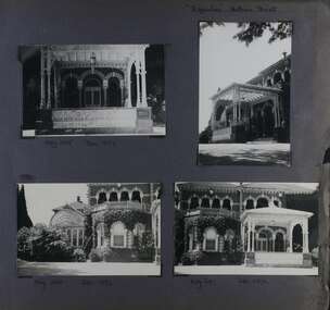
Photograph, Liz Pidgeon, Heritage Excursion; The 1901 Eltham Railway Walk, 3 May 2014, 3 May 2014
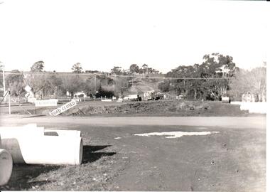
... was opened in 1902. Over the previous year railway construction cut... was opened in 1902. Over the previous year railway construction cut ...Newsletter No. 216, May 2014 May Excursion – The 1901 Eltham Railway Walk The railway from Heidelberg to Eltham was opened in 1902. Over the previous year railway construction cut a curving swathe through Josiah Holloway’s 1851 Little Eltham subdivision. The survey plans for the railway show the owners and occupiers of land within Little Eltham affected by the railway alignment and for some distance each side. The plans show houses and other buildings but development at that time was rather sparse. Copies of these plans from the State Library of Victoria collection have been provided to the Society by Alan Sheehan. For our walk on 3rd May we intend to follow the railway from the Eltham Station to Ryans Road, which was the boundary of the adjoining Montmorency Farm. The return will be by way of nearby streets. Along the way we will discuss the details shown on the railway plans as well as more recent railway documents and photographs. At the conclusion and if time permits we can inspect the historical display at the Eltham Station. The walk is about 3 km in length and will take about 2.5 hours. It will start at 2 pm at the Eltham Railway Station car park (east/Main Road side) (Melway Ref. 21 J5).Born Digitalheritage excursion, activities, eltham district historical society, eltham railway station, eltham library, trestle bridge -
 Eltham District Historical Society Inc
Photograph, Liz Pidgeon, Heritage Excursion; The 1901 Eltham Railway Walk, 3 May 2014, 3 May 2014
... was opened in 1902. Over the previous year railway construction cut... was opened in 1902. Over the previous year railway construction cut ...EDHS Member Doug Orford stands by a yarn bombing installation. ewsletter No. 216, May 2014 May Excursion – The 1901 Eltham Railway Walk The railway from Heidelberg to Eltham was opened in 1902. Over the previous year railway construction cut a curving swathe through Josiah Holloway’s 1851 Little Eltham subdivision. The survey plans for the railway show the owners and occupiers of land within Little Eltham affected by the railway alignment and for some distance each side. The plans show houses and other buildings but development at that time was rather sparse. Copies of these plans from the State Library of Victoria collection have been provided to the Society by Alan Sheehan. For our walk on 3rd May we intend to follow the railway from the Eltham Station to Ryans Road, which was the boundary of the adjoining Montmorency Farm. The return will be by way of nearby streets. Along the way we will discuss the details shown on the railway plans as well as more recent railway documents and photographs. At the conclusion and if time permits we can inspect the historical display at the Eltham Station. The walk is about 3 km in length and will take about 2.5 hours. It will start at 2 pm at the Eltham Railway Station car park (east/Main Road side) (Melway Ref. 21 J5).Born Digitalheritage excursion, activities, eltham district historical society, eltham railway station, eltham library, trestle bridge, yarn bombing, doug orford -
 Eltham District Historical Society Inc
Photograph, Liz Pidgeon, Heritage Excursion; The 1901 Eltham Railway Walk, 3 May 2014, 3 May 2014
... was opened in 1902. Over the previous year railway construction cut... was opened in 1902. Over the previous year railway construction cut ...Newsletter No. 216, May 2014 May Excursion – The 1901 Eltham Railway Walk The railway from Heidelberg to Eltham was opened in 1902. Over the previous year railway construction cut a curving swathe through Josiah Holloway’s 1851 Little Eltham subdivision. The survey plans for the railway show the owners and occupiers of land within Little Eltham affected by the railway alignment and for some distance each side. The plans show houses and other buildings but development at that time was rather sparse. Copies of these plans from the State Library of Victoria collection have been provided to the Society by Alan Sheehan. For our walk on 3rd May we intend to follow the railway from the Eltham Station to Ryans Road, which was the boundary of the adjoining Montmorency Farm. The return will be by way of nearby streets. Along the way we will discuss the details shown on the railway plans as well as more recent railway documents and photographs. At the conclusion and if time permits we can inspect the historical display at the Eltham Station. The walk is about 3 km in length and will take about 2.5 hours. It will start at 2 pm at the Eltham Railway Station car park (east/Main Road side) (Melway Ref. 21 J5).Born Digitalheritage excursion, activities, eltham district historical society, eltham railway station, eltham library, trestle bridge -
 Kiewa Valley Historical Society
Headphone Set x2
Radio Telephone was minuted during the war. it was approved in 1944 for the State Electricity Commission of Victoria's use only. it was completed by the end of 1946. used by the State Electricity Commission of Victoria at Bogong during the construction of the Kiewa Hydro Electric Scheme to connect with head office in Melbourne. It allows one conversation at a time using traffic controls in an unusual system of radio telephone providing communication. At the time it was unique in Australia and installed by the S.E.C.V. technicians. It provided unattended shortwave radio link between two ordinary telephone switchboards, connecting any of the S.E.C.V.'s internal lines with the telephone system at Bogong and the construction camps beyond. From Bogong, radio phones connected to the outpost stations on the High Plains far above the snow-line. In operation, the service was similar to a normal telephone system but dispensed with the physical connection of wires and poles between the main terminals.Historical: This headphone set superseded headphones with two earpieces and those without a microphone. This one may have been used by operators on the switchboard at Bogong or Mt Beauty or one of the construction camps on the Kiewa Hydro Electric Scheme. The S.E.C.V. installed this unique system of communication to operate their branches especially at Bogong and beyond where the distance was great and often limited by the terrain and weather.Radio Telephone for SECV switchboard. Black plastic earpiece with microphone. Ear side circular with inscription on outer side then formed into elongated shape narrowing to the curved speaker piece at the narrow end. On top of the narrow end a long rubber cord is attached to a thick brass pin. On top of the wider end a thin stiff wire is attached to curve around the head to a blank rubber earpiece. This head piece has a piece of rectangular rubber attached at the top for comfort.'4408A IW61 / 1'radio telephone, ear phones, head phones. head set. communications, state electricity commission of victoria. kiewa hydro electric scheme. bogong. switchboards -
 Kiewa Valley Historical Society
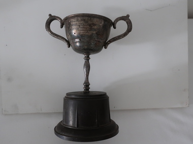
Trophies - Bogong Primary School
Trophies were awarded to recognise achievements in many areas of the school curriculum. Sir Kenneth George Luke (1896-1971) was a successful businessman and VFL football administrator. K.G.Luke was a private mint that made 1956 Olympic Games medals for the Numismatic Association of Victoria. It operated between 1937 and 1974. Note: 'Rosebowl replica' may refer to the Rose Bowl Home of the UCLA Football Layered Wooden Stadium Replica With the Los Angeles Campus Skyline. (A football reference for the shape of the trophy?)Bogong Primary School was built for the workers of the SECV during the construction of the Kiewa Hydro Electric Scheme. The school was well equiped and presented a broad curriculum enjoying participation in many organisations. A. Bakelite base with stained metal cup attached to a metal stem with a cup on top. The cup has 2 curved handles and an inscription between them on one side. B. Bakelite base with a metal stained 'silver' cup attached. The cup has a 'neck' with the cup on top. The cup has one curved handle. The other handle is missing. Previously UKV 058 and UKV 061B. The K. G. Luke / Trophy for replica sustained interest in bird study / presented / State School 4590 / Bogong / for sustained interest / in bird study A. "A.M.V -4 / Pet Parade / Save the Children / Fund bogong primary school, pet parade, bird study, k.g. luke trophy -
 Kiewa Valley Historical Society
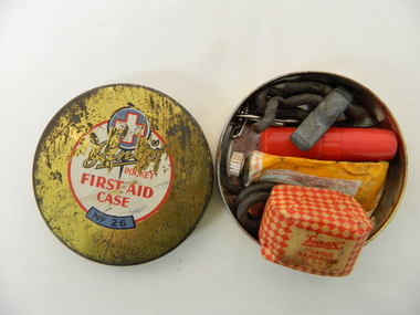
Functional object - Pocket First Aid, Circa mid 1900s
This pocket First Aid kit is small and compact which became available to those venturing out in the outback and required an easily managed first aid kit. It was manufactured in the mid 1900s well before vinyl and or plastic pouches or bags where used. It was in an era where valuable items were stored in durable containers due to the harsh and rugged conditions of the Australian bush. Cheaper and less durable containers from Asian manufacturers had been kept out by the heavy Tariff imposed on their goods. This changed in the 1980's when the Tariff Board was dismantled by a then Labour Government. The Australian manufacturing industry was severely reduced by the Influx of cheaper goods. This item was made by an Australian company when the motto "true blue" was the catch cry for quality Australian made goods. This was in the period where the isolation of many rural communities required the basic first aid kits to be of a tougher quality than those offered in large cities and towns.This pocket first aid kit was very compact and would have been easy to carry without taking up too much space for bush walkers, camping scouts, drovers and independent miners and cattlemen. The Kiewa Valley and surrounding rural settlements did not have the medical backup that the larger cities and towns had up until the mid 1900s when the Hydro Electricity Schemes were built and the additional influx of workers made it feasible to have a hospital and better local health facilities. This influx of the construction workers associated with the Hydro Scheme. also brought European workers who where more inclined to go bush walking and climbing the Victorian alps than the average Australian rural worker. This item is a Sanax pocket first aid round tin, gold in colour with red and white print. It's contents are: one small tube of Sanax antiseptic cream, one small one inch x six yards of gauze bandages, rubber band type ligatures with a cast iron tightener., one small tweezers three safety pins, and one lancet.On the lid there are: are outlined white cross on a blue circular background. underneath is a whiite circle encased with a red line with the following printed "Sanax pocket first aid case" (in red print underneath this is a small curved blue background and in black print "No. 26"medicine, first aid tin, camping medical supplies, personal first aid, sanax -
 Glen Eira Historical Society
Album - Album page, "Ripponlea", Hotham Street, Circa 1972
This photograph is part of the Caulfield Historical Album 1972. This album was created in approximately 1972 as part of a project by the Caulfield Historical Society to assist in identifying buildings worthy of preservation. The album is related to a Survey the Caulfield Historical Society developed in collaboration with the National Trust of Australia (Victoria) and Caulfield City Council to identify historic buildings within the City of Caulfield that warranted the protection of a National Trust Classification. Principal photographer thought to be Trevor Hart, member of Caulfield Historical Society. Most photographs were taken between 1966-1972 with a small number of photographs being older and from unknown sources. All photographs are black and white except where stated, with 386 photographs over 198 pages.From Victorian Heritage Database citation for Rippon Lea H0614 https://vhd.heritagecouncil.vic.gov.au/places/427(as at 23/10/2020) Rippon Lea was commenced in 1868 by Frederick Sargood, a most successful politician and merchant. He was born in England in 1834 and arrived in Melbourne in 1850. He soon joined his father's wholesale soft goods firm, spending some time as its manager on the goldfields. Sargood entered the Legislative Council in 1874. He was Victoria?s first Minister for Defence in 1883. Sir Frederick Sargood was created CMG. In 1885 and KCMG in 1890 as a reward for his contribution to public life. He died suddenly in 1903. Rippon Lea was designed by the leading firm of architects, Reed and Barnes. Joseph Reed had travelled in Europe in 1863, including northern Italy. When he returned he introduced the use of polychromy. While not the first examples, Rippon Lea and the Independent Church in Collins Street were the best and set a fashion which became a distinctly Melbourne style, particularly used for houses and churches. Its popularity was possible because of the new availability of different coloured bricks. Reed's fine Lombardic Romanesque details soon became debased by others. As Sargood's family grew and his fortunes prospered, Rippon Lea was extended to include 33 rooms - a complete mansion. The cast iron porte cochere and the northern conservatory were added in 1897. The architects were Taylor and Fitts. The ballroom was added in 1882 and remodelled in 1889. Many alterations have changed the interior and exterior during the ownerships of Benjamin Nathan and later his daughter Mrs Louisa Jones in the 1930s and are in their own right of significance. Sir Thomas Bent owned the property from 1903 until 1911 but never lived there. He subdivided much of the land. The original garden dates from about 1868, and it seems that William Guilfoyle of the Botanic Gardens was involved. It was redesigned in a more natural style in the 1880s by Sargood and his head gardener, Adam Anderson. The lake, waterfalls, fernery, hill and grotto are balanced by mighty deciduous trees and conifers. These are interspersed with, but never dominated by Australian species such as eucalyptus and other exotics. The sinuous drive with its carefully prepared approach to the house is notable. The original vegetable gardens, orchard and outer paddocks no longer survive. The shade house is important as the largest known in Australia and possibly the world. Its curved plan and form of construction are particularly notable. It was built about 1884.Page 94 of Photograph Album with four photographs (three landscape and one portrait) of Ripponlea - stables, lookout and neighbouring cottages.Handwritten: "Ripponlea" Hotham Street [top right] / Neg 256 Dec 1972 STABLES [under top left photo] / Neg 248 Dec 1972 LOOKOUT [under top right photo] / Neg 254 Dec 1972 / COTTAGES WILLOW STREET [under bottom left photo] / Neg 259 Dec 1972 STABLES [under bottom right photo] / 94 [bottom right]trevor hart, elsternwick, mansion, hotham street, frederick sargood, reed and barnes, 1860's, 1890's, 1880's, benjamin nathan, nathan, louisa jones, thomas bent, sir thomas bent, william guilfoyle, guilfoyle, adam anderson, ripponlea, victorian, sir frederick sargood, architects, bricks, polychrome bricks, taylor and fitts, stables, lookouts, cottages, outbuildings, rippon lea -
 Glen Eira Historical Society
Photograph, Beauville Avenue, 18, Murrumbeena, 2001
Originally labelled "Beauville Estate, Established 1936, Still Thriving 65 years on, 10th March 2001", the Beauville Estate Album contains colour photographs of houses in the Estate. They were taken around the time of the Beauville Estate’s 65th Heritage Celebration held on 10/03/2001 and donated to the Caulfield Historical Society shortly afterwards. Photographer unknown.City of Glen Eira’s Heritage Management Plan Vol 2 p79 (this is p84 of the pdf version) – HO12 Beauville Estate and environs, Murrumbeena: The Beauville Historic Area is important at the State level as the first large housing estate undertaken by the AV Jennings Construction Co, later Jennings Group Limited, Victoria’s largest home builder. It is important also as a very early estate development incorporating a range of features other than houses and including made roads, shops and recreation facilities. In this respect it was the forerunner of the comprehensively planned housing estate of the post war era. The estate is distinguished by its aesthetic values, as is the earlier and comparable Hillcrest Estate, which are formed by a combination of restrained diversity in house styles, with the exception of no. 30 in the emerging International style, and by a landscaped garden environment. Colour photograph of cream rendered house. Other features include a curved porch with pillars, tiled roof and low unpainted brick fence in the foreground. murrumbeena, houses, beauville avenue, architectural styles, 1930's, inter war style, a.v. jennings, av jennings, jennings, brick houses, beauville estate, porches, sir albert victor jennings, a v jennings construction co, beauville estate heritage area, glen eira city council, architectural features, jennings group limited, land subdivision, gardens, beauville historic area, rendered houses, brick fences -
 Glen Eira Historical Society
Photograph, Beauville Avenue, 19, Murrumbeena, 2001
Originally labelled "Beauville Estate, Established 1936, Still Thriving 65 years on, 10th March 2001", the Beauville Estate Album contains colour photographs of houses in the Estate. They were taken around the time of the Beauville Estate’s 65th Heritage Celebration held on 10/03/2001 and donated to the Caulfield Historical Society shortly afterwards. Photographer unknown.City of Glen Eira’s Heritage Management Plan Vol 2 p79 (this is p84 of the pdf version) – HO12 Beauville Estate and environs, Murrumbeena: The Beauville Historic Area is important at the State level as the first large housing estate undertaken by the AV Jennings Construction Co, later Jennings Group Limited, Victoria’s largest home builder. It is important also as a very early estate development incorporating a range of features other than houses and including made roads, shops and recreation facilities. In this respect it was the forerunner of the comprehensively planned housing estate of the post war era. The estate is distinguished by its aesthetic values, as is the earlier and comparable Hillcrest Estate, which are formed by a combination of restrained diversity in house styles, with the exception of no. 30 in the emerging International style, and by a landscaped garden environment. Colour photograph of white rendered house. Other features include an enclosed porch with a curved wall and cast iron entrance door, tiled roof, chimney and low unpainted brick fence in the foreground with a garden behind. murrumbeena, houses, beauville avenue, architectural styles, 1930's, inter war style, a.v. jennings, av jennings, jennings, brick houses, beauville estate, porches, sir albert victor jennings, a v jennings construction co, beauville estate heritage area, glen eira city council, architectural features, jennings group limited, land subdivision, gardens, beauville historic area, rendered houses, curved porches, cast iron work, chimneys, brick fences -
 Glen Eira Historical Society
Photograph, Beauville Avenue, 22, Murrumbeena, 2001
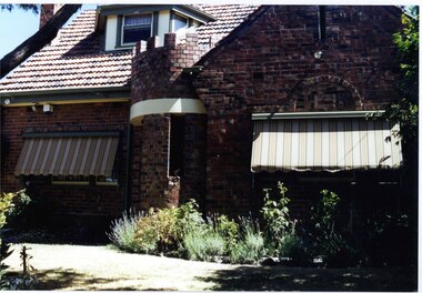
Originally labelled "Beauville Estate, Established 1936, Still Thriving 65 years on, 10th March 2001", the Beauville Estate Album contains colour photographs of houses in the Estate. They were taken around the time of the Beauville Estate’s 65th Heritage Celebration held on 10/03/2001 and donated to the Caulfield Historical Society shortly afterwards. Photographer unknown.City of Glen Eira’s Heritage Management Plan Vol 2 p79 (this is p84 of the pdf version) – HO12 Beauville Estate and environs, Murrumbeena: The Beauville Historic Area is important at the State level as the first large housing estate undertaken by the AV Jennings Construction Co, later Jennings Group Limited, Victoria’s largest home builder. It is important also as a very early estate development incorporating a range of features other than houses and including made roads, shops and recreation facilities. In this respect it was the forerunner of the comprehensively planned housing estate of the post war era. The estate is distinguished by its aesthetic values, as is the earlier and comparable Hillcrest Estate, which are formed by a combination of restrained diversity in house styles, with the exception of no. 30 in the emerging International style, and by a landscaped garden environment. Colour photograph of unpainted brick house with decorative brick features. Other features include a curved wall porch with a crenelated parapet, tiled roof, dormer window and striped awnings on the ground floor windows. murrumbeena, houses, beauville avenue, architectural styles, 1930's, inter war style, a.v. jennings, av jennings, jennings, brick houses, beauville estate, porches, sir albert victor jennings, a v jennings construction co, beauville estate heritage area, glen eira city council, architectural features, jennings group limited, land subdivision, gardens, beauville historic area, brick features, dormer windows, striped awnings, towers -
 Glen Eira Historical Society
Photograph, Beauville Avenue, 22, Murrumbeena, 2001
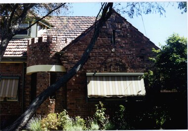
Originally labelled "Beauville Estate, Established 1936, Still Thriving 65 years on, 10th March 2001", the Beauville Estate Album contains colour photographs of houses in the Estate. They were taken around the time of the Beauville Estate’s 65th Heritage Celebration held on 10/03/2001 and donated to the Caulfield Historical Society shortly afterwards. Photographer unknown.City of Glen Eira’s Heritage Management Plan Vol 2 p79 (this is p84 of the pdf version) – HO12 Beauville Estate and environs, Murrumbeena: The Beauville Historic Area is important at the State level as the first large housing estate undertaken by the AV Jennings Construction Co, later Jennings Group Limited, Victoria’s largest home builder. It is important also as a very early estate development incorporating a range of features other than houses and including made roads, shops and recreation facilities. In this respect it was the forerunner of the comprehensively planned housing estate of the post war era. The estate is distinguished by its aesthetic values, as is the earlier and comparable Hillcrest Estate, which are formed by a combination of restrained diversity in house styles, with the exception of no. 30 in the emerging International style, and by a landscaped garden environment. Colour photograph of unpainted brick house with decorative brick features and also cream render features. Other features include a curved wall porch with a crenelated parapet, tiled roof, dormer window and striped awnings on the ground floor windows. A tree branch can be seen in the foreground.murrumbeena, houses, beauville avenue, architectural styles, 1930's, inter war style, a.v. jennings, av jennings, jennings, brick houses, beauville estate, porches, sir albert victor jennings, a v jennings construction co, beauville estate heritage area, glen eira city council, architectural features, jennings group limited, land subdivision, gardens, beauville historic area, towers, dormer windows, striped awnings, brick and cream render features -
 Glen Eira Historical Society
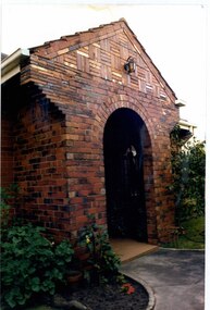
Photograph, Beauville Avenue, 27, Murrumbeena, 2001
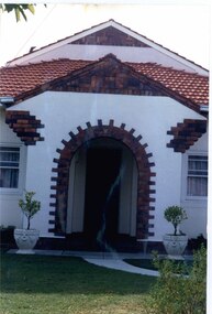
Originally labelled "Beauville Estate, Established 1936, Still Thriving 65 years on, 10th March 2001", the Beauville Estate Album contains colour photographs of houses in the Estate. They were taken around the time of the Beauville Estate’s 65th Heritage Celebration held on 10/03/2001 and donated to the Caulfield Historical Society shortly afterwards. Photographer unknown.City of Glen Eira’s Heritage Management Plan Vol 2 p79 (this is p84 of the pdf version) – HO12 Beauville Estate and environs, Murrumbeena: The Beauville Historic Area is important at the State level as the first large housing estate undertaken by the AV Jennings Construction Co, later Jennings Group Limited, Victoria’s largest home builder. It is important also as a very early estate development incorporating a range of features other than houses and including made roads, shops and recreation facilities. In this respect it was the forerunner of the comprehensively planned housing estate of the post war era. The estate is distinguished by its aesthetic values, as is the earlier and comparable Hillcrest Estate, which are formed by a combination of restrained diversity in house styles, with the exception of no. 30 in the emerging International style, and by a landscaped garden environment. Colour photograph of the porch and surrounds for a white rendered house with unpainted variegated brown brick features and a later second storey addition. The porch has a wide decorative arched entrance, garden urns in front of the porch and a curved concrete path through the lawn to the porch. murrumbeena, houses, beauville avenue, architectural styles, 1930's, inter war style, a.v. jennings, av jennings, jennings, brick houses, beauville estate, porches, arches, sir albert victor jennings, a v jennings construction co, beauville estate heritage area, glen eira city council, architectural features, jennings group limited, land subdivision, gardens, beauville historic area, brick features, outdoor ornaments, rendered houses, gables -
 Glen Eira Historical Society
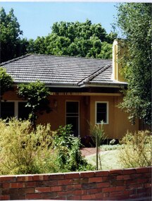
Photograph, Murrumbeena Road, 226, Murrumbeena, 2001
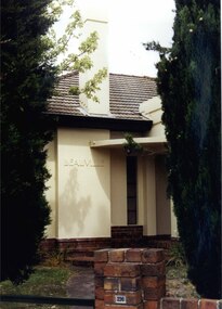
Originally labelled "Beauville Estate, Established 1936, Still Thriving 65 years on, 10th March 2001", the Beauville Estate Album contains colour photographs of houses in the Estate. They were taken around the time of the Beauville Estate’s 65th Heritage Celebration held on 10/03/2001 and donated to the Caulfield Historical Society shortly afterwards. Photographer unknown. City of Glen Eira’s Heritage Management Plan Vol 2 p79 (this is p84 of the pdf version) – HO12 Beauville Estate and environs, Murrumbeena: The Beauville Historic Area is important at the State level as the first large housing estate undertaken by the AV Jennings Construction Co, later Jennings Group Limited, Victoria’s largest home builder. It is important also as a very early estate development incorporating a range of features other than houses and including made roads, shops and recreation facilities. In this respect it was the forerunner of the comprehensively planned housing estate of the post war era. The estate is distinguished by its aesthetic values, as is the earlier and comparable Hillcrest Estate, which are formed by a combination of restrained diversity in house styles, with the exception of no. 30 in the emerging International style, and by a landscaped garden environment. Colour photograph of a cream rendered brick house. Other features include a porch with a flat curved roof, brick steps, tall chimney with "Beauville" written on the bottom section, a tiled roof and an unpainted variegated brown brick fence in the foreground with "226" on the pillar.Beauvillemurrumbeena, houses, architectural styles, 1930's, inter war style, a.v. jennings, av jennings, jennings, brick houses, beauville estate, porches, murrumbeena road, sir albert victor jennings, a v jennings construction co, beauville estate heritage area, glen eira city council, architectural features, jennings group limited, land subdivision, gardens, beauville historic area, brick features, brick fences, chimneys, beauville, house names -
 Glen Eira Historical Society
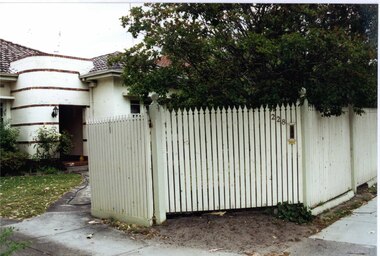
Photograph, Murrumbeena Road, 228, Murrumbeena, 2001
Originally labelled "Beauville Estate, Established 1936, Still Thriving 65 years on, 10th March 2001", the Beauville Estate Album contains colour photographs of houses in the Estate. They were taken around the time of the Beauville Estate’s 65th Heritage Celebration held on 10/03/2001 and donated to the Caulfield Historical Society shortly afterwards. Photographer unknown.City of Glen Eira’s Heritage Management Plan Vol 2 p79 (this is p84 of the pdf version) – HO12 Beauville Estate and environs, Murrumbeena: The Beauville Historic Area is important at the State level as the first large housing estate undertaken by the AV Jennings Construction Co, later Jennings Group Limited, Victoria’s largest home builder. It is important also as a very early estate development incorporating a range of features other than houses and including made roads, shops and recreation facilities. In this respect it was the forerunner of the comprehensively planned housing estate of the post war era. The estate is distinguished by its aesthetic values, as is the earlier and comparable Hillcrest Estate, which are formed by a combination of restrained diversity in house styles, with the exception of no. 30 in the emerging International style, and by a landscaped garden environment. See Significance Statement in Glen Eira’s Heritage Management Plan by Andrew Ward (1996) Vol 2 p.79. Available from https://www.gleneira.vic.gov.au/media/4779/heritage_management_plan_volume_2.pdf (Note see p.84 of pdf)Colour photograph of a white, rendered, brick house. Other features include an enclosed porch with a curved wall decorated with narrow bands of bricks, a tiled roof and a tall white picket fence and gate with "228" and a letterbox in the middle section.murrumbeena, houses, architectural styles, 1930's, inter war style, a.v. jennings, av jennings, jennings, brick houses, beauville estate, porches, jennings albert victor, murrumbeena road, sir albert victor jennings, a v jennings construction co, beauville estate heritage area, glen eira city council, architectural features, jennings group limited, land subdivision, gardens, beauville historic area, rendered houses, brick features, picket fences -
 Glen Eira Historical Society
Photograph, Beauville Avenue, 33, Murrumbeena, 2001
Originally labelled "Beauville Estate, Established 1936, Still Thriving 65 years on, 10th March 2001", the Beauville Estate Album contains colour photographs of houses in the Estate. They were taken around the time of the Beauville Estate’s 65th Heritage Celebration held on 10/03/2001 and donated to the Caulfield Historical Society shortly afterwards. Photographer unknown. City of Glen Eira’s Heritage Management Plan Vol 2 p79 (this is p84 of the pdf version) – HO12 Beauville Estate and environs, Murrumbeena: The Beauville Historic Area is important at the State level as the first large housing estate undertaken by the AV Jennings Construction Co, later Jennings Group Limited, Victoria’s largest home builder. It is important also as a very early estate development incorporating a range of features other than houses and including made roads, shops and recreation facilities. In this respect it was the forerunner of the comprehensively planned housing estate of the post war era. The estate is distinguished by its aesthetic values, as is the earlier and comparable Hillcrest Estate, which are formed by a combination of restrained diversity in house styles, with the exception of no. 30 in the emerging International style, and by a landscaped garden environment. Colour photograph of a closeup view of an unpainted variegated brown brick porch belonging to a barely visible house. The enclosed porch features an arched entrance, patterned decorative brickwork and a lamp above the arch. A garden path curves out either side of the porch and its garden.murrumbeena, houses, architectural styles, 1930's, inter war style, a.v. jennings, av jennings, jennings, brick houses, beauville estate, porches, sir albert victor jennings, a v jennings construction co, beauville estate heritage area, glen eira city council, architectural features, jennings group limited, land subdivision, gardens, beauville historic area, brick features, arches, beauville avenue -
 Glen Eira Historical Society
Photograph, Dalny Road, 25, Murrumbeena, 2001
Originally labelled "Beauville Estate, Established 1936, Still Thriving 65 years on, 10th March 2001", the Beauville Estate Album contains colour photographs of houses in the Estate. They were taken around the time of the Beauville Estate’s 65th Heritage Celebration held on 10/03/2001 and donated to the Caulfield Historical Society shortly afterwards. Photographer unknown. City of Glen Eira’s Heritage Management Plan Vol 2 p79 (this is p84 of the pdf version) – HO12 Beauville Estate and environs, Murrumbeena: The Beauville Historic Area is important at the State level as the first large housing estate undertaken by the AV Jennings Construction Co, later Jennings Group Limited, Victoria’s largest home builder. It is important also as a very early estate development incorporating a range of features other than houses and including made roads, shops and recreation facilities. In this respect it was the forerunner of the comprehensively planned housing estate of the post war era. The estate is distinguished by its aesthetic values, as is the earlier and comparable Hillcrest Estate, which are formed by a combination of restrained diversity in house styles, with the exception of no. 30 in the emerging International style, and by a landscaped garden environment. Colour photograph of a light tan rendered brick house with a small curved additional roof jutting over the front door. Other features include tiled roof, white framed windows, door and guttering, feature chimney and a low unpainted variegated brown brick fence in the foreground with bushes and lawn behind the fence. Tall trees behind the house.murrumbeena, houses, architectural styles, 1930's, inter war style, a.v. jennings, av jennings, jennings, brick houses, beauville estate, dalny road, sir albert victor jennings, a v jennings construction co, beauville estate heritage area, glen eira city council, architectural features, jennings group limited, land subdivision, gardens, beauville historic area, rendered houses, chimneys, brick fences -
 Glen Eira Historical Society
Album - Album page, Ripponlea, 192 Hotham Street, Circa 1972
This photograph is part of the Caulfield Historical Album 1972. This album was created in approximately 1972 as part of a project by the Caulfield Historical Society to assist in identifying buildings worthy of preservation. The album is related to a Survey the Caulfield Historical Society developed in collaboration with the National Trust of Australia (Victoria) and Caulfield City Council to identify historic buildings within the City of Caulfield that warranted the protection of a National Trust Classification. Principal photographer thought to be Trevor Hart, member of Caulfield Historical Society. Most photographs were taken between 1966-1972 with a small number of photographs being older and from unknown sources. All photographs are black and white except where stated, with 386 photographs over 198 pages.From Victorian Heritage Database citation for Rippon Lea H0614 https://vhd.heritagecouncil.vic.gov.au/places/427(as at 23/10/2020) Rippon Lea was commenced in 1868 by Frederick Sargood, a most successful politician and merchant. He was born in England in 1834 and arrived in Melbourne in 1850. He soon joined his father's wholesale soft goods firm, spending some time as its manager on the goldfields. Sargood entered the Legislative Council in 1874. He was Victoria's first Minister for Defence in 1883. Sir Frederick Sargood was created CMG. In 1885 and KCMG in 1890 as a reward for his contribution to public life. He died suddenly in 1903. Rippon Lea was designed by the leading firm of architects, Reed and Barnes. Joseph Reed had travelled in Europe in 1863, including northern Italy. When he returned he introduced the use of polychromy. While not the first examples, Rippon Lea and the Independent Church in Collins Street were the best and set a fashion which became a distinctly Melbourne style, particularly used for houses and churches. Its popularity was possible because of the new availability of different coloured bricks. Reed's fine Lombardic Romanesque details soon became debased by others. As Sargood's family grew and his fortunes prospered, Rippon Lea was extended to include 33 rooms - a complete mansion. The cast iron porte cochere and the northern conservatory were added in 1897. The architects were Taylor and Fitts. The ballroom was added in 1882 and remodelled in 1889. Many alterations have changed the interior and exterior during the ownerships of Benjamin Nathan and later his daughter Mrs Louisa Jones in the 1930s and are in their own right of significance. Sir Thomas Bent owned the property from 1903 until 1911 but never lived there. He subdivided much of the land. The original garden dates from about 1868, and it seems that William Guilfoyle of the Botanic Gardens was involved. It was redesigned in a more natural style in the 1880s by Sargood and his head gardener, Adam Anderson. The lake, waterfalls, fernery, hill and grotto are balanced by mighty deciduous trees and conifers. These are interspersed with, but never dominated by Australian species such as eucalyptus and other exotics. The sinuous drive with its carefully prepared approach to the house is notable. The original vegetable gardens, orchard and outer paddocks no longer survive. The shade house is important as the largest known in Australia and possibly the world. Its curved plan and form of construction are particularly notable. It was built about 1884.Page 90 of Photograph Album with five photographs (one landscape and 4 portrait) of Ripponlea - two different views of the front entrance to the mansion, one of the front gates and two different views of the main residence.Handwritten: "Ripponlea" 192 Hotham Street [top right] / North [under top left photo] / Neg 255 Dec 1972 MAIN DRIVE [under bottom left photo] / Neg 238 8 OCT 1966 [under middle right photo] / 88 [bottom right]trevor hart, elsternwick, mansion, hotham street, frederick sargood, reed and barnes, cast iron porte cochere, conservatory, 1860's, 1890's, ballroom, 1880's, benjamin nathan, louisa jones, thomas bent, sir thomas bent, william guilfoyle, adam anderson, lake, grotto, shade house, portico, ripponlea, victorian, sir frederick sargood, architects, polychrome bricks, lombardic romanesque architectural style, rippon lea, taylor and fitts, land subdivisions, gardens, drives, vegetable gardens, orchards -
 Glen Eira Historical Society
Album - Album page, Ripponlea, 192 Hotham Street, Circa 1972
This photograph is part of the Caulfield Historical Album 1972. This album was created in approximately 1972 as part of a project by the Caulfield Historical Society to assist in identifying buildings worthy of preservation. The album is related to a Survey the Caulfield Historical Society developed in collaboration with the National Trust of Australia (Victoria) and Caulfield City Council to identify historic buildings within the City of Caulfield that warranted the protection of a National Trust Classification. Principal photographer thought to be Trevor Hart, member of Caulfield Historical Society. Most photographs were taken between 1966-1972 with a small number of photographs being older and from unknown sources. All photographs are black and white except where stated, with 386 photographs over 198 pages.From Victorian Heritage Database citation for Rippon Lea H0614 https://vhd.heritagecouncil.vic.gov.au/places/427(as at 23/10/2020) Rippon Lea was commenced in 1868 by Frederick Sargood, a most successful politician and merchant. He was born in England in 1834 and arrived in Melbourne in 1850. He soon joined his father's wholesale soft goods firm, spending some time as its manager on the goldfields. Sargood entered the Legislative Council in 1874. He was Victoria?s first Minister for Defence in 1883. Sir Frederick Sargood was created CMG. In 1885 and KCMG in 1890 as a reward for his contribution to public life. He died suddenly in 1903. Rippon Lea was designed by the leading firm of architects, Reed and Barnes. Joseph Reed had travelled in Europe in 1863, including northern Italy. When he returned he introduced the use of polychromy. While not the first examples, Rippon Lea and the Independent Church in Collins Street were the best and set a fashion which became a distinctly Melbourne style, particularly used for houses and churches. Its popularity was possible because of the new availability of different coloured bricks. Reed's fine Lombardic Romanesque details soon became debased by others. As Sargood's family grew and his fortunes prospered, Rippon Lea was extended to include 33 rooms - a complete mansion. The cast iron porte cochere and the northern conservatory were added in 1897. The architects were Taylor and Fitts. The ballroom was added in 1882 and remodelled in 1889. Many alterations have changed the interior and exterior during the ownerships of Benjamin Nathan and later his daughter Mrs Louisa Jones in the 1930s and are in their own right of significance. Sir Thomas Bent owned the property from 1903 until 1911 but never lived there. He subdivided much of the land. The original garden dates from about 1868, and it seems that William Guilfoyle of the Botanic Gardens was involved. It was redesigned in a more natural style in the 1880s by Sargood and his head gardener, Adam Anderson. The lake, waterfalls, fernery, hill and grotto are balanced by mighty deciduous trees and conifers. These are interspersed with, but never dominated by Australian species such as eucalyptus and other exotics. The sinuous drive with its carefully prepared approach to the house is notable. The original vegetable gardens, orchard and outer paddocks no longer survive. The shade house is important as the largest known in Australia and possibly the world. Its curved plan and form of construction are particularly notable. It was built about 1884.Page 91 of Photograph Album with four photographs (two portrait and two landscape) of various external views of Ripponlea.Handwritten: SOUTH [under top left photo] / SOUTH [under top right photo] / WEST [under bottom left photo] / 91 [bottom left]trevor hart, elsternwick, mansion, hotham street, frederick sargood, reed and barnes, cast iron porte cochere, conservatory, 1860's, 1890's, ballroom, 1880's, benjamin nathan, louisa jones, thomas bent, sir thomas bent, william guilfoyle, adam anderson, lake, grotto, shade house, portico, ripponlea, victorian, sir frederick sargood, architects, taylor and fitts, rippon lea, polychrome bricks, lombardic romanesque style -
 Glen Eira Historical Society
Album - Album page, Ripponlea, Hotham Street, Circa 1972
This photograph is part of the Caulfield Historical Album 1972. This album was created in approximately 1972 as part of a project by the Caulfield Historical Society to assist in identifying buildings worthy of preservation. The album is related to a Survey the Caulfield Historical Society developed in collaboration with the National Trust of Australia (Victoria) and Caulfield City Council to identify historic buildings within the City of Caulfield that warranted the protection of a National Trust Classification. Principal photographer thought to be Trevor Hart, member of Caulfield Historical Society. Most photographs were taken between 1966-1972 with a small number of photographs being older and from unknown sources. All photographs are black and white except where stated, with 386 photographs over 198 pages.From Victorian Heritage Database citation for Rippon Lea H0614 https://vhd.heritagecouncil.vic.gov.au/places/427(as at 23/10/2020) Rippon Lea was commenced in 1868 by Frederick Sargood, a most successful politician and merchant. He was born in England in 1834 and arrived in Melbourne in 1850. He soon joined his father's wholesale soft goods firm, spending some time as its manager on the goldfields. Sargood entered the Legislative Council in 1874. He was Victoria?s first Minister for Defence in 1883. Sir Frederick Sargood was created CMG. In 1885 and KCMG in 1890 as a reward for his contribution to public life. He died suddenly in 1903. Rippon Lea was designed by the leading firm of architects, Reed and Barnes. Joseph Reed had travelled in Europe in 1863, including northern Italy. When he returned he introduced the use of polychromy. While not the first examples, Rippon Lea and the Independent Church in Collins Street were the best and set a fashion which became a distinctly Melbourne style, particularly used for houses and churches. Its popularity was possible because of the new availability of different coloured bricks. Reed's fine Lombardic Romanesque details soon became debased by others. As Sargood's family grew and his fortunes prospered, Rippon Lea was extended to include 33 rooms - a complete mansion. The cast iron porte cochere and the northern conservatory were added in 1897. The architects were Taylor and Fitts. The ballroom was added in 1882 and remodelled in 1889. Many alterations have changed the interior and exterior during the ownerships of Benjamin Nathan and later his daughter Mrs Louisa Jones in the 1930s and are in their own right of significance. Sir Thomas Bent owned the property from 1903 until 1911 but never lived there. He subdivided much of the land. The original garden dates from about 1868, and it seems that William Guilfoyle of the Botanic Gardens was involved. It was redesigned in a more natural style in the 1880s by Sargood and his head gardener, Adam Anderson. The lake, waterfalls, fernery, hill and grotto are balanced by mighty deciduous trees and conifers. These are interspersed with, but never dominated by Australian species such as eucalyptus and other exotics. The sinuous drive with its carefully prepared approach to the house is notable. The original vegetable gardens, orchard and outer paddocks no longer survive. The shade house is important as the largest known in Australia and possibly the world. Its curved plan and form of construction are particularly notable. It was built about 1884.Page 92 of Photograph Album with four photographs (three landscape and one portrait) of Ripponlea - views of entrance and left front of mansion.Handwritten: "Ripponlea" Hotham Street [top right] / Neg 245 Dec 1972 [under top left photo] / Neg 246 Dec 1972 [under bottom left photo] / Neg 247 Dec 1972 [under bottom right photo] / 92 [bottom right]trevor hart, elsternwick, mansion, hotham street, frederick sargood, reed and barnes, lombardic, romanesque, cast iron porte cochere, conservatory, 1860's, 1890's, ballroom, 1880's, benjamin nathan, louisa jones, thomas bent, sir thomas bent, william guilfoyle, adam anderson, lake, grotto, shade house, portico, ripponlea, victorian, sir frederick sargood, architects, polychrome bricks, lombardic romanesque style, rippon lea, entrances -
 Glen Eira Historical Society
Album - Album page, Ripponlea, Hotham Street, Circa 1972
This photograph is part of the Caulfield Historical Album 1972. This album was created in approximately 1972 as part of a project by the Caulfield Historical Society to assist in identifying buildings worthy of preservation. The album is related to a Survey the Caulfield Historical Society developed in collaboration with the National Trust of Australia (Victoria) and Caulfield City Council to identify historic buildings within the City of Caulfield that warranted the protection of a National Trust Classification. Principal photographer thought to be Trevor Hart, member of Caulfield Historical Society. Most photographs were taken between 1966-1972 with a small number of photographs being older and from unknown sources. All photographs are black and white except where stated, with 386 photographs over 198 pages.From Victorian Heritage Database citation for Rippon Lea H0614 https://vhd.heritagecouncil.vic.gov.au/places/427(as at 23/10/2020) Rippon Lea was commenced in 1868 by Frederick Sargood, a most successful politician and merchant. He was born in England in 1834 and arrived in Melbourne in 1850. He soon joined his father's wholesale soft goods firm, spending some time as its manager on the goldfields. Sargood entered the Legislative Council in 1874. He was Victoria?s first Minister for Defence in 1883. Sir Frederick Sargood was created CMG. In 1885 and KCMG in 1890 as a reward for his contribution to public life. He died suddenly in 1903. Rippon Lea was designed by the leading firm of architects, Reed and Barnes. Joseph Reed had travelled in Europe in 1863, including northern Italy. When he returned he introduced the use of polychromy. While not the first examples, Rippon Lea and the Independent Church in Collins Street were the best and set a fashion which became a distinctly Melbourne style, particularly used for houses and churches. Its popularity was possible because of the new availability of different coloured bricks. Reed's fine Lombardic Romanesque details soon became debased by others. As Sargood's family grew and his fortunes prospered, Rippon Lea was extended to include 33 rooms - a complete mansion. The cast iron porte cochere and the northern conservatory were added in 1897. The architects were Taylor and Fitts. The ballroom was added in 1882 and remodelled in 1889. Many alterations have changed the interior and exterior during the ownerships of Benjamin Nathan and later his daughter Mrs Louisa Jones in the 1930s and are in their own right of significance. Sir Thomas Bent owned the property from 1903 until 1911 but never lived there. He subdivided much of the land. The original garden dates from about 1868, and it seems that William Guilfoyle of the Botanic Gardens was involved. It was redesigned in a more natural style in the 1880s by Sargood and his head gardener, Adam Anderson. The lake, waterfalls, fernery, hill and grotto are balanced by mighty deciduous trees and conifers. These are interspersed with, but never dominated by Australian species such as eucalyptus and other exotics. The sinuous drive with its carefully prepared approach to the house is notable. The original vegetable gardens, orchard and outer paddocks no longer survive. The shade house is important as the largest known in Australia and possibly the world. Its curved plan and form of construction are particularly notable. It was built about 1884.Page 93 of Photograph Album with four photographs (two landscape and two portrait) of Ripponlea - lake and gardens.Handwritten: Neg 239 Dec 1973 LAKE [under top left photo] / Neg 242 Dec 1973 FERN HOUSE [under top right photo] / Neg 243 Dec 1972 FERN HOUSE [under bottom left photo] / Neg 241 Dec 1972 LAKE [under bottom right photo] / 93 [bottom left]trevor hart, elsternwick, mansion, hotham street, frederick sargood, sargood, reed and barnes, 1860's, 1890's, 1880's, benjamin nathan, nathan, louisa jones, thomas bent, sir thomas bent, william guilfoyle, adam anderson, lake, grotto, shade house, portico, ripponlea, victorian, sir frederick sargood, architects, taylor and fitts, rippon lea, gardens, ferns, bridges, walking trails -
 Flagstaff Hill Maritime Museum and Village
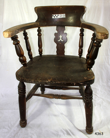
Furniture - Chair, ca. 1900
The timber on this captain's chair has been worn smooth across the backrest. It is of solid construction. A captain's chair is typically a wooden armchair with a back that curves around to form the armrests. The style of chair was used in the 19th century and was a statement of status aboard a ship. This captain's chair is an example of the type of furniture used onboard a ship in the 19th and early 20th centuries.Captain's chair; an oak armchair with a low curved back that forms the armrests. It has six turned spindles, a fretted back, a solid saddle seat and is supported on four turned legs. The timber backrest feels smooth and well-worn. Circa 1900.flagstaff hill, flagstaff hill maritime museum and village, warrnambool, maritime museum, maritime village, great ocean road, shipwreck coast, wooden chair, captain's chair, armchair, 19th century furniture, nautical furniture, seating -
 Federation University Historical Collection
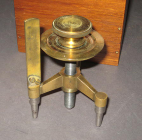
Scientific Instrument, Spherometer
A spherometer is an instrument for the precise measurement of the radius of curvature of a sphere or a curved surface. Originally, these instruments were primarily used by opticians to measure the curvature of the surface of a lens. A fixed-frame tripod with adjustable central contact screw, equipped with micrometer scale. Brass construction with steel contact points. Designed for measuring curvature of lenses. Stored in a polished timber box. Made specially for Silberberg and Co. Ltd. Melbournescientific instrument, spherometer, h.b. silberberg & co ltd -
 Glenelg Shire Council Cultural Collection
Photograph - Photograph - silo construction, n.d
Port of Portland Authority ArchivesBack: 90% in pencilport of portland archives -
Glenelg Shire Council Cultural Collection
Photograph - Photograph - Main Breakwater construction, Portland, n.d
Port of Portland Authority Archivesport of portland archives, main breakwater, construction, harbour development, crane -
 Puffing Billy Railway
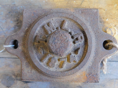
Axle Box Cover - Tasmanian Main Line Co, 1874
Axle box cover from a Tasmanian Main Line Railway rail vehicle from 1874 The Tasmanian Main Line Railway Company (T.M.R.L.) was a privately owned railway company that existed in Tasmania from 1872 to 1890. The company were the first operators of rail services between Hobart and Launceston, where it connected with the Launceston and Western Railway (L.W.R.) It started construction of a 3' 6" gauge line between Hobart and Launceston in 1873 which was completed in December 1875. and was officially opened on 1 November 1876. The route of the railway was selected largely as a result of vocal local interests and accordingly traversed some reasonably unfavorable topography, particularly in the southern section. Because the TMLR had limited finances, the line was built to the narrow (1067 mm) gauge and included long sections of steep gradients and sharp curves. The final eighteen kilometres of the route from Western Junction to Launceston used the existing broad gauge alignment of the Launceston and Western Railway, with a third rail being laid for use by the narrow gauge trains A close but uncomfortable relationship with the Government was resolved in 1890 with the purchase of the company's assets by the Crown and their incorporation into the Tasmanian Government Railways on 1 October 1890. Historic early Tasmanian Main Line Railway - Vehicle Axel Box cover Axle box cover from a Tasmanian Main Line rail vehicle from 1874.T.M.L.R - 1874 -axle, tasmanian main line railway, axle box, tasmania, main line, -
 Hume City Civic Collection
Photograph, Early 1970s
The two arch bluestone bridge which spanned the Jacksons Creek was replaced in the early 1970s with a wider double lane bridge. Dangerous curves were also taken out of the road. The area in the foreground on the RHS has now been incorporated into a public picnic area.A black and white photograph of road works taking place on the Sunbury Road over Jacksons Creek. Large concrete drain pipes are in the foreground and on the RHS of the photograph with roadwork signs on the LHS. Three trucks are at the foot of the hill.macedon street, macedon street road bridge, jacksons creek, road construction, george evans collection -
 Ballarat Heritage Services
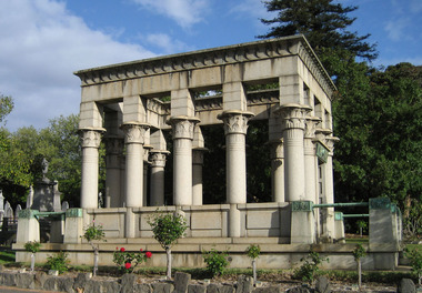
photograph - Digital photographs, L.J. Gervasoni, Syme Memorial Boroondara General Cemetery, c2010, c2005-2015
The Boroondara General Cemetery is registered by Heritage VictoriaFrom Heritage Victoria Statement of Significance Last updated on - December 15, 2005 (undated change to citation made since 2005) What is significant? Boroondara Cemetery, established in 1858, is within an unusual triangular reserve bounded by High Street, Park Hill Road and Victoria Park, Kew. The caretaker's lodge and administrative office (1860 designed by Charles Vickers, additions, 1866-1899 by Albert Purchas) form a picturesque two-storey brick structure with a slate roof and clock tower. A rotunda or shelter (1890, Albert Purchas) is located in the centre of the cemetery: this has an octagonal hipped roof with fish scale slates and a decorative brick base with a tessellated floor and timber seating. The cemetery is surrounded by a 2.7 metre high ornamental red brick wall (1895-96, Albert Purchas) with some sections of vertical iron palisades between brick pillars. Albert Purchas was a prominent Melbourne architect who was the Secretary of the Melbourne General Cemetery from 1852 to 1907 and Chairman of the Boroondara Cemetery Board of Trustees from 1867 to 1909. He made a significant contribution to the design of the Boroondara Cemetery. Boroondara Cemetery is an outstanding example of the Victorian Garden Cemetery movement in Victoria, retaining key elements of the style, despite overdevelopment which has obscured some of the paths and driveways. Elements of the style represented at Boroondara include an ornamental boundary fence, a system of curving paths which are kerbed and follow the site's natural contours, defined views, recreational facilities such as the rotunda, a landscaped park like setting, sectarian divisions for burials, impressive monuments, wrought and cast iron grave surrounds and exotic symbolic plantings. In the 1850s cemeteries were located on the periphery of populated areas because of concerns about diseases like cholera. They were designed to be attractive places for mourners and visitors to walk and contemplate. Typically cemeteries were arranged to keep religions separated and this tended to maintain links to places of origin, reflecting a migrant society. Other developments included cast iron entrance gates, built in 1889 to a design by Albert Purchas; a cemetery shelter or rotunda, built in 1890, which is a replica of one constructed in the Melbourne General Cemetery in the same year; an ornamental brick fence erected in 1896-99(?); the construction and operation of a terminus for a horse tram at the cemetery gates during 1887-1915; and the Springthorpe Memorial built between 1897 and 1907. ... ... The Syme Memorial (1908) is a memorial to David Syme, political economist and publisher of the Melbourne Age newspaper. The Egyptian memorial designed by architect Walter Richmond Butler is one of the most finely designed and executed pieces of monumental design in Melbourne. It has a temple like form with each column having a different capital detail. These support a cornice that curves both inwards and outwards. The tomb also has balustradings set between granite piers which create porch spaces leading to the entrance ways. Two variegated Port Jackson Figs are planted at either end. ... How is it significant? Boroondara Cemetery is of aesthetic, architectural, scientific (botanical) and historical significance to the State of Victoria. ... ...Digital image of the Syme memorial in Boroondara Cemetery, Kew. cemetery, boroondara, kew, gatehouse, clock, tower, clocktower, heritage, memorial