Showing 968 items matching "dams"
-
 Kiewa Valley Historical Society
Photo - Junction Dam, September 1941
Junction Dam was part of the Hydro Electric Scheme during the 1940'sState Electricity Commission of Victoria construction of the Kiewa Hydro Electric SchemeBlack & white photo of Junction Dam constructionjunction dam, secv, bogong -
 Tarnagulla History Archive
Photograph - Photograph: Company's Dam, Tarnagulla, c. 1930s
Williams Family Collection. Monochrome photograph depicting Company's Dam, Tarnagulla, view from Gladstone St, looking towards Methodist Church. Original photographic print. Handwritten on reverse: 'Company's Dam Looking Towards Methodist Church'.tarnagulla -
 Stawell Historical Society Inc
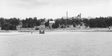
Photograph, Wonga Companies Plant and Dam 1899
Jubilee Dam in foreground that supplied water used in the Cyanide process.B/W photo looking at plant across damstawell mining -
 Kiewa Valley Historical Society
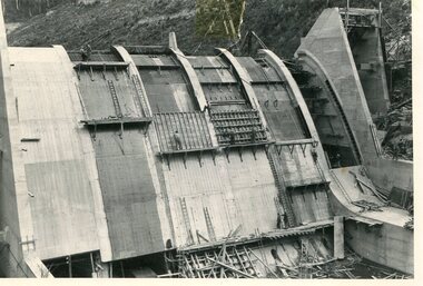
Photo - Junction Dam, December 1941
Junction Dam was part of the Hydro Electricity Scheme during the 1940'sState Electricity Commission of Victoria (S.E.C.V.) construction of the Kiewa Hydro Electric SchemeBlack and white photograph of Junction Dam formwork constructionjunction dam, bogong, secv -
 Kiewa Valley Historical Society
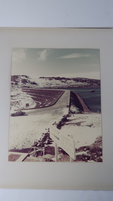
Photo - Rocky Valley Dam
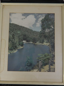
The State Electricity Commission of Victoria constructed the Kiewa Hydro Electric Scheme on the Bogong High Plains. The scheme consisted of storage dams and pondages, aqueducts, tunnels, pipelines, transmission lines and three power stations.. Rocky Valley dam was the biggest storage and the last to be completed.Rocky Valley dam was the largest storage within the Kiewa Hydro Electric Scheme. Begun in 1954 and completed in 1960. It was linked to McKay Creek Power StationColoured photo attached to cream cardboard. The background shows hills and the foreground a sign "Rocky Valley Dam ..." The middle shows the dam with water and its bank. There is snow on the ground.rocky valley dam, kiewa hydro electric scheme, secv -
 Falls Creek Historical Society
Photograph - Building Rocky Valley Dam Wall
The Rocky Valley Dam is located on the Bogong High Plains, near Falls Creek, Victoria. The dam is man-made and has a capacity of 28,000 megalitres (990×106 cu ft). At an elevation of 1600m, Rocky Valley Dam is the highest significant body of water in Australia. The dam was created for the Kiewa Hydroelectric Scheme. Just a short distance from the heart of the village, the lake provides a playground for a range of aquatic activities. It is also utilised in snow making for the Falls Creek ski resort. Work began on the Rocky Valley Dam site in early 1947 and continued until May. It resumed in October after the winter and a camp for the accommodation of workmen was commenced at this time. Work continued in 1948 with the establishment of work facilities, including the erection of two large excavators. The Rocky Valley Dam was completed in 1959.These images are significant as they capture work carried out to build the wall at Rocky Valley near Falls Creek, VictoriaThree black and white images showing work on the Rocky Valley Dam, Victoriarocky valley dam, kiewa hydroelectric scheme, falls creek -
 Heidelberg Golf Club
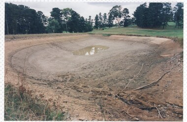
Photograph, The dam drained, May 1998, May 1998
... Dams ...The dam drained, May 1998, Heidelberg Golf ClubColour photograph of a golf courseheidelberg golf club, dams -
 Kiewa Valley Historical Society
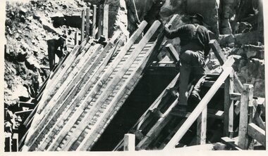
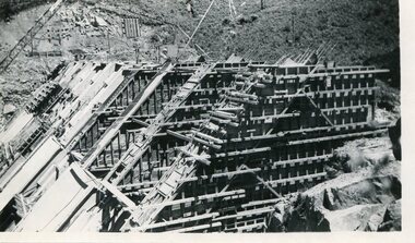
Photo - Junction Dam Construction, Circa 1940's
Junction (Lake Guy) Dam is a 'slab and buttress' type wall. A timber frame is built and then filled with concrete. The first batch of concrete was placed in September, 1940. By June, 1941 the buttresses were finished to a height safe from floods and in October of that year a flood of 2,800 cusecs occurred but with only slight damage to the installations. Industrial trouble caused some delays but there was also slow progress on the part of the contractor and the work was taken over by the S.E.C., terminating the contract. The dam was completed in March, 1944. A walkway was made through the dam wall. Lake Guy was named after Mr. L.T. Guy who was the Resident engineer, in charge of construction work and associated activities on the Kiewa Area from 1939 to November 1946Photos of the construction of the Junction Dam detail the harsh conditions faced by construction workers, building dams and villages to accommodate workers in the 1940s to the 1950s. Australia at this period in time, experienced a surge of population (influx of World War II refugees), which was the catalyst for developing and undergoing an enormous hydroelectricity program for the Alpine regions, both in Victoria and New South Wales. This program was initiated to supply electricity to the major southern Australian cities of Adelaide, Melbourne and Sydney. It was thought that these developments would reduce, if not eliminate, the requirement for coal driven power stations. However time has demonstrated that these power stations have not matched the demand required by the industries and the populations of the major urban and cities.Black and white photograph of Junction Dam constructionjunction dam, bogong, secv -
 Kiewa Valley Historical Society
Photo - Junction Dam, 19/08/1940
Junction Dam was part of the Hydro Electricity Scheme during the 1940'sState Electricity Commission (S.E.C.V.) construction of the Kiewa Hydro Electric SchemeBlack and white photograph of Junction Dam construction. View from upstream.junction dam, bogong, secv -
 Linton and District Historical Society Inc
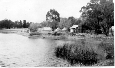
Photograph, Dredge hut, Granny's Paddock
... Dams ...Black and white photograph of a hut located beside a dam of water.dams, mines, dredging, buildings, huts, granny's paddock -
Tatura Irrigation & Wartime Camps Museum
Folio, Eildon Dam, 1950s
Eildon Dam documentary story and photgraphy compiled into folio for Tatura Museum by Frank Burns, BCE, and presented to the Museum Irrigation Room collection by him March 1995Folio - Brief history of the construction of Eildon Dam with accompanying photosirrigation, eildon, frank burns, eildon dam -
 Heidelberg Golf Club
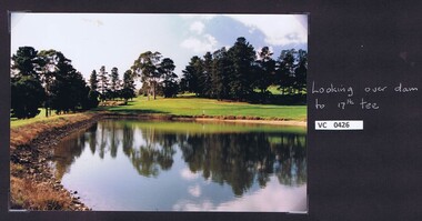
Photograph, Looking over dam to 17th tee: Heidelberg Golf Club, 2000c
... Dams ...Looking over dam to 17th tee: Heidelberg Golf ClubColour photograph and caption.hgc course, 17th tee, dams -
Glenelg Shire Council Cultural Collection
Photograph, n.d
Sourced from Casterton Town Hall (former Shire of Glenelg)Black and white photo. Same section of gully as item number 7238, but looking upstream. Closer view of concrete pipes? Soil saving dam.Back: Black stamp '57' 'Soil Saving Dam looking upstream' 'Gb 4239' - handwritten, pencil -
 Wonga Park Community Cottage History Group
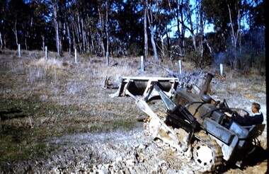
photograph, dam making, c 1940 for 1003 c1960 for 1003-1
Ernie Kear and his son Bruce were local excavators and involved in many projects around Wonga Park requiring bull dozing, in particular clearing land for orchards, building dams etcEarly history of Wonga Park orchard growing district. Early dams were built by horse and scoop on the back which was handled by the orchardist, or the dam builder but later replaced by bulldozersErnie Kear excavating a dam in Wonga Park c 1940 no hard copy electronic only -
 Whitehorse Historical Society Inc.
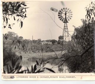
Photograph, Dam and windmill on Livermore Orchard in Vermont
Black & white photo of dam and windmill at Doug Livermore's Orchard in Vermont. (see also NP500)Black & white photo of dam and windmill at Doug Livermore's Orchard in Vermont. (see also NP500)orchards, livermores orchard, dams and reservoirs -
 El Dorado Museum Association Inc.
Photograph - Digital Image
Steven's (Stevensons) Dam after breaking. -
 Mt Dandenong & District Historical Society Inc.
Photograph
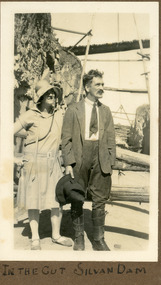
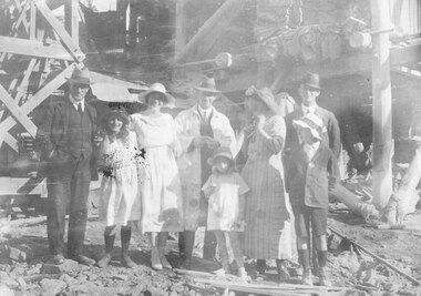
The photograph shows Ivy May Child standing with her father Ted Child at the Silvan Dam worksite. The construction of Silvan Dam took place between 1926 and the 1932 opening. Ivy May Child (1910 – 1989) was the daughter of Arthur Edward (Ted) Child (1878 – 1964) and Ethel May Madden (1888 – 1970). Ted Child was the son of Matthew Francis Child (1839 – 1933) and Martha Jeeves (1857 – 1926). He was the grandson of one of the early pioneers Francis Child. Ivy grew up on the family property on Childs Road and took many photographs. Most of these are glued into her photo album. The album covered the years from c1927 – 1932. Ivy married Henry William Burgess (1906 – 1968) in 1944. The photographs remain in their original state in the album with individual copies made. Black and white photograph showing a man and woman standing in a cutting. The woman is in a dress and wearing a shady hat. The man is wearing a jacket and jodhpur like trousers with leather gaiters. He is holding a wide brimmed hat.Written below photo in album: IN THE CUT SILVAN DAMivy child, ted child, silvan dam -
 Marysville & District Historical Society
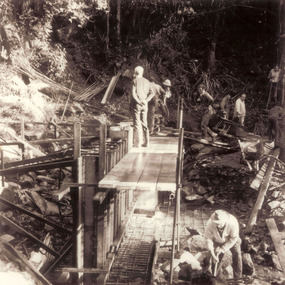
Photograph (item) - Black and white photograph, Unknown
A black and white photograph which shows a group of men constructing the form work for the dam at the base of Steavenson Falls.A black and white photograph shows a group of men constructing the form work for the dam at the base of Steavenson Falls. Steavenson Falls provides Marysville with the town's drinking water which is considered to be the second-best drinking water in the world. The Steavenson Falls are named after the Victorian Assistant Commissioner of Roads and Bridges, John Steavenson who arrived in Victoria in the early 1860s.steavenson falls, marysville, victoria, waterfalls, john steavenson, 2009 black saturday bushfires -
 Kiewa Valley Historical Society
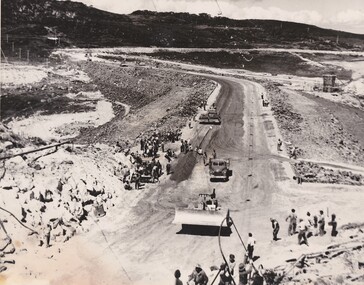
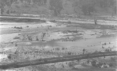
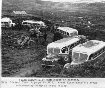
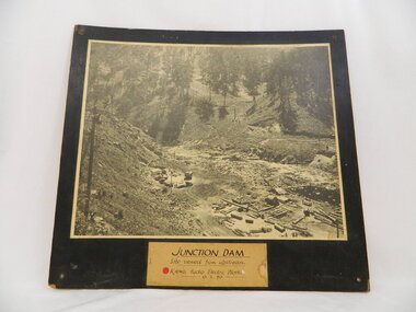
Photograph - Parlimentary Party visiting Rocky Valley Dam site, 15-4-1948
This photograph was taken during construction of the Rocky Valley Dam and wall. Work was commenced in early 1947 but had to be suspended during winter and then resumed in October. Work continued in 1948 with the establishment of work facilities and, at the dam site, the river was diverted through a temporary pipeline. Rocky Valley and associated spillway and outlet works were completed in 1959.A pictorial record of the construction of the rock and earth filled dam wall at Rocky Valley. Shows the extent of the project undertaken and the level of importance of the project as indicated by the large representation at the parliamentary party visit on 15/4/48.Photocopy of black and white photograph of parliamentary party visiting Rocky Valley Dam site 15/04/1948Typed on the bottom of photocopy - State Electricity Commission of Victoria. Date: 15-4-48 Time: 4.30pm No: K4397. Kiewa Hydro-Electric works. Parlimentary Party at Rocky Valleyrocky valley dam, parliamentary party, secv -
 Ringwood and District Historical Society
Photograph, Miles family members and friends at Maroondah Dam, c 1923-24
Black and white photograph showing group posing in front of construction works of dam.Written on back of photograph: "J. C. Allan, Joan Miles, Gwen Miles nee Trethowan, A.jT. Miles, Mrs. Trethowan, man unknown. June and Paddy in front. Maroondah Dam about 1923-24." -
 Kiewa Valley Historical Society
Framed photo - Clover Power Station and Dam
Clover Dam and Power Station were built by the State Electricity Commission of Victoria as part of the Kiewa Hydro Electric Scheme from the late 1930's to the early 1940's.This photo is part of the local history and was owned by Mr ad Mrs Gordon White, SECV employee and long time residents.White wooden frame coloured photo with white cardboard surrounds of Clover Power Station and Dam.clover dam; clover power station; bogong; kiewa hydro electric scheme; -
 Linton and District Historical Society Inc
Photograph, Making A Dam at Linton, undated
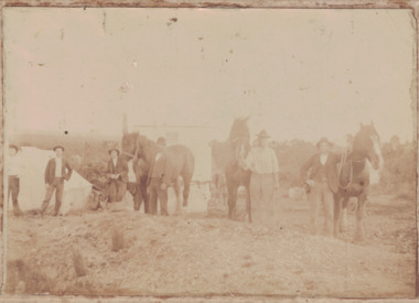
... Dams ...Sepia image of a group of men with horses and shovels making a dam. There are six men and three horses in the foreground. A building is behind them. Image has been adhered to a backing card.horses, dams, dam building, working life -
 Linton and District Historical Society Inc
Photograph, Dam Builders, Battery Dam, Linton, 1910
... Dams ...Mounted black and white image. William (or Richard?) Ching and team with horses and drays, creating water dam at Linton, 1910battery dam, dam building, dam workers, dams, horses, working life -
 Eltham District Historical Society Inc
Photograph, George W. Bell, Smiths Dam, Eltham, 1961, 1961
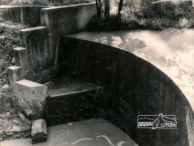
... dams ...Black and white photograph of concrete dam on Smith property Karingal Drive Eltham 1961karingal drive, st helena road, d.b smith, eltham west drain, karingal creek, st helena creek, dams, george w bell collection -
University of Melbourne, Burnley Campus Archives
Photograph - Colour print, Kodak, Excursion, Unknown
... dams ...13 colour photographs taken possibly on an excursion. Views of the countryside, river, valley mountains, dams, farm buildings.excursion, countryside, river, valley, mountains, dams, farm buildings -
 Linton and District Historical Society Inc
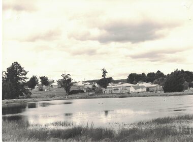
Photograph, View of Linton from across Edinburgh Dam, 1984
Image taken 1984. House on right in middle-ground belonged to Rutherford family (prior to this it was the police residence; it was moved to this site in the 1960s). Small white building near Rutherford house was formerly the Linton Railway Station office building.Black and white image of a body of water, Edinburgh Dam - in foreground. Houses and shops (along Sussex Street) in background."Linton from across the / Edinburgh Dam. The little / white hut behind Rutherfords / (right foreground) was the / office building from Linton / Railway Station, moved / to this site c. 1981/2".edinburgh dam, rutherford house -
 University of Melbourne, Burnley Campus Archives
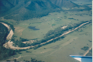
Photograph - Colour print, Aerial View of Countryside, Unknown
... dams ...4 colour photographs taken from a small aeroplane. Views of countryside, river, valley, mountains, dams, farm buildings countryside, aerial views, river, valley, farm buildings, dams, mountains -
 Kiewa Valley Historical Society
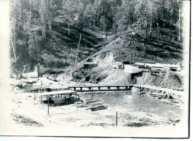
Photo of Junction Dam - Kiewa Hydro Electric Scheme, Junction Dam, Kiewa Hydro Electric Scheme, Photo taken 10th Feb. 1940
The Junction Dam was built by the State Electricity Commission of Victoria as part of the Kiewa Hydro Electric Scheme. This photo show its construction in February 1940. The State Electricity Commission of Victoria were the employers of the Kiewa Hydro Scheme. The work included building dams, power stations and the infrastructure for the work and their employees. Mt Beauty and Bogong village were the places where this scheme was built and where this photo shows part of its construction being Power Station 3. Originally there were 3 Hydro stations built from the 1930's onwards. The scheme finished being built in 1960 and is the biggest Hydro electricity scheme in Victoria.This photo has Historic significance due to Junction Dam built as part of the Kiewa Hydro Electric Scheme by the State Electricity Commission of Victoria. This photo shows its construction in February 1940. This is a black and white photo of Junction Dam viewed from upstream. Junction Dam was part of the Kiewa Hydro Electric Scheme. The picture shows piles of wood and pipes, crane, trucks and a shed on the cleared ground. The photo is mounted on 3 ply wood, painted black.kiewa hydro electric scheme. junction dam. s.e.c.v.. -
 Stawell Historical Society Inc
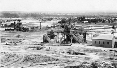
Photograph, Sloane's & Scotchman United Mining Co in Stawell looking North West with Poppet Heads & Sheds 1914 -- Photo & Colured Painting
Poppet Heads, Ore bin Winding Engine Shed Sloane's & Scotchmans United Quartz Mining Co looking North West Moonlight dams in background. Mine on left is the old Extended mine where the winding engine shed has been destroyed by fire. Just behind that is the Winding Engine Shed of the Oriental Mine without the poppet head.View of two mine sites with poppet heads and engine sheds. Settling dams in background.mining, panorama -
 Stawell Historical Society Inc
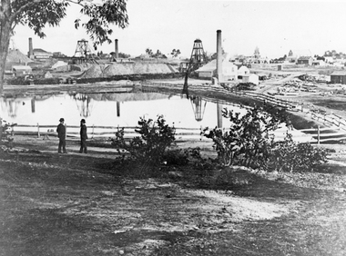
Photograph, The Pleasant Creek Cross Reef No1 Shaft Panorama of a Mining Scene in the Duke Sands area c1875
Mining Scene Duke Sands area c1875 Behind the tree on left is Extended Cross Mine and on the right is the Oriental Mine. In the centre is the North Cross Mine No1 shaft. In the foreground is one of the Moonlight dams. St Peters Lutheran Church in Scallan Street can be seen on the right horizon. Two mines and workings on other side of Moonies settling dam. Two Gentlemen lower left cornerstawell mining