Showing 119 items
matching department of conservation
-
 Federation University Historical Collection
Booklet, Little Desert National Park and Wail State Forest Proposed Management Plan, 1991, 11/1991
... Department of conservation and environment... Department of conservation and environment rod gowans don spence ...Grey soft covered report of 80 pages. Includes a pull out map.little desert national park, wait state forest, management plan, horsham, department of conservation and environment, rod gowans, don spence, wimmera river, threatened plants, fauna, flora, birds, mammals, wergaia, scarred trees, mounds, pest plants, pest animals, tourism and recreation, timber, grazing, conservation -
 Bendigo Historical Society Inc.
Document - BENDIGO SALEYARDS COLLECTION: THE BENDIGO SALEYARDS ECONOMIC VIABILITY STUDY
... Department of Conservation Forests and Land... Shire Council Department of Industry Technology & Resources ...140 Loose pages titled The Bendigo Saleyards Economic Viability Study. Report written by Kate Millard on behalf of the Bendigo Development Committee Inc. Contents include: Chapter 1 - Background Information, Chapter 1 - Present Operations at the Saleyards, Chapter 3 - Economic Factors, Chapter 4 - Environmental Factors, Chapter 5 - Selling Techniques, Chapter 6 - Employment Study, Management and Sundry Issues, Chapter 7 - Survey of Farmers and Saleyard Users in the 'Catchment Area', and Chapter 8 - Recommendations of the Report. Includes diagrams and maps. Recommendations printed on dark yellow paper.bendigo, council, cattle markets, bendigo saleyards collection - the bendigo saleyards economic viability study, bendigo development committee inc., kate millard, loddon campaspe planning authority, street, ryan and associates, bendigo city council, strathfieldsaye shire council, department of industry technology & resources, national library of australia, meldrum burows & partners, core wilson sayer, town planning appeals panel, ces, victorian farmers and graziers association, stock agents association, department of agriculture, department of industry technology & resources, department of conservation forests and land, cr jock comini, rca depot, wellsford rifle range, bendigo airport, bendigo field naturalists club, mr david kennedy, mr john brumby, mr john radford, neil o'keefe, bendigo east progress association, bendigo east traders, trades hall council, mr tom uren, mr frank wilkes, mr bruce reid, mr k i m wright, mr e t ebery, bendigo pastoral council of the vfga, victorian meatworks association, bendigo stock & station agents association, rutlands transport, mr don pickles, country abattoirs & wholesalers association association of victoria, meat and allied trade federation of australia, bendigo saleyards advisory committee, bendigo residents & ratepayers association, a h & n graham, mrs p unmack australian bureau of statistics, mr lloyd houlden, cr c rodda, mr jolly, mr tony milanese, dr robert carter, university of melbourne, bendigo college of tafe, t matthews, a s & r d rutland, john kerr, j talbot, g l o'sullivan, penney & lang pty ltd, graeme pickering, pickhall j w & sons, r a plant, w k schmidt, t j vick, k & j wignall, a e wright, g chapman, a j gillies, p g & m m harris, ian r hollingsworth, b kennedy, s letcher, s & d k letcher, p m llewellyn, l g mason, boyer r t, connally m f, kennedy & mortlock, nevins j p, r w johnstone, w j keith, b d kelly, notman r, pitts a j & c a, pitts mervyn l & co, rowe w o, warren k m, associated stock & station agents, dalgety farmers ltd, elders dsm estates, ellis nuttall & co, gallagher g d, hamilton real estate, mcgregor ralph h & co, mckean w & co, miller turner livestock co, vains e m & co, victorian producers, hill m j & co, bennetts meats, comell bros, davis b & d, hardwick g f & v c, penney & lang p/l, tendercut meats, northern seed supply co, bendigo fertilizers, agri business pty ltd, agrilink consulting group pty ltd, acil aust pty ltd, mcgowan & associates, chapman w c, talbot e j, mcculloch w & sons pty ltd, k v equipment, commercial egg producers assoc co-op, monsanto aust ltd, balmer bryan r, barry i j, bath l, clarke b j, treacy k m, turner j m, bendigo mower serv pty ltd, everlast concrete tank tyltd, wicks bros, canvas goods, don mcarthur, bendigo communications, transcom, emdell pty ltd, epsom pharmaceutical supplies, sandhurst fencing pty ltd, arnolds gates & fencing, r furniss, carne neville, awa & unicla, ajm refrigeration, bendigo concrete sawing service, hamilton r j, hearpes t w, j e brown, campey dr a r, fyffe j j, kangaroo flat vet clinic, ottrey k e, bendigo sprinkler installations, milnes irrigation, onga pumpshop, barastoc products, bush's produce stores, epsom produce, k m m pty ltd, bendigo grain co, eaglehawk chaff mills, grain elevators board dept, bonneys pest control, knights pest control, brown wk & l d, bendigo sewerage authority, bendigo water board, aci computer services, leham donald, a e hueffer & associates, wolmoke planners, p langley, mr ken strachan, mr evan jones, mr peter byrnes, mr wayne street, street ryan & associates -
 Whitehorse Historical Society Inc.
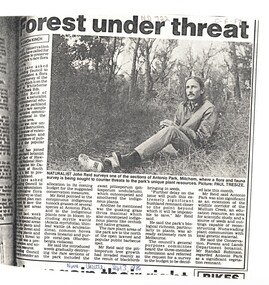
Article, Forest under threat, 13/09/1986 12:00:00 AM
... victoria. department of conservation forests and lands... robinson randall victoria. department of conservation forests ...An article in the Nunawading Gazette, naturalist John Reid has asked Council to commission a survey of flora and fauna of Antonio Park, Mitcham before this significant bushland remnant is impossible to save.native plants, antonio park, mitcham, reid, john, robinson, randall, victoria. department of conservation forests and lands -
 Whitehorse Historical Society Inc.
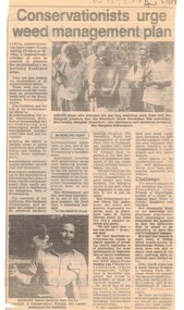
Article, Conservationists to urge weed management plan, 5/04/1989 12:00:00 AM
... victoria. department of conservation... Mitcham melbourne environment weeds victoria. department ...Article from Nunawading Gazette dated 5 April 1989 about a weed management plan in the City of Nunawading.environment, weeds, victoria. department of conservation, forests and lands., native plants, edwards, margaret, meagher, dorothy, witherspoon, cameron, david -
 Bendigo Historical Society Inc.
Document - HERITAGE REPORT: FORMER POLICE STATION AND QUARTERS: CALIFORNIA GULLY
... Department of Conservation and Natural Resources... in the Sandhurst Eaglehawk and Raywood Mining Divisions Department ...Seventeen page Heritage Place Report on the Former California Gully Police Station at 15 Thorpe Street, California Gully. It is the former police station and quarters, former timber stables and timber cottage residence demolished and horse paddock on separate title. Report includes a Statement of Significance, Place History (History of the Area), Policing California Gully Goldfields, History of the Buildings, Chronology of Ownership, Rate Books 1858, - 1867 - 1868, 1895 Borough of Eaglehawk Rates, 1922 Voters Roll, 1952 & 1962 Sands & McDougall Directory Thorpe St California Gully, Comparable Examples, Secondary Sources, Description Conservation Policy Guidelines (Specific), Physical Conditions, Physical Description 1, Map of Early Photo Location, Bendigo Parish Plan circa 1870, Certificate of Title 1950 & 1960. Pge 14 has plans, maps and an aerial photo of 15 Thorpe Street. Page 15 has an aerial photo of 15 Thorpe Street, California Gully with Allotment Size. Page 16 & 17 has photos.heritage, heritage report - former police station and quarters - california gully, city of greater bendigo, wilson & ass, butler, amanda jean, johnson reef shafts no 1 & 2, rose of denmark, princess dagmar, bendigo amalgamated goldfields company, captain frederick standish, royal irish constabulary, e thorpe, campbell, taylor, watson, brown, hosken, mckowne, mcqualter, parker, hicks, eaglehawk municipal council, victorian police force, d bannear, historic mining sites in the sandhurst eaglehawk and raywood mining divisions, department of conservation and natural resources, joshua thorpe, thorpe & co, johnson & co, william thorn, michael thomas, james murdock, edward c brown, francis youlden, gold escort, water police, mounted police, city police (melbourne), geelong police, gold fields police, rural bench constabulary, the people's force, robert haldane, n wild, streets of the borough of eaglehawk, police registration act, william henry mitchell, camp hotel, j o c nieman, j m catarach, g w hosken, margaret hosken nee mckown, majorie alice mcqualter, kellie anne mcqualter, adam joseph doolan, mr hicks, sands & mcdougall, hill george, meeking howard, mcewan frank a, jinks stanley, mccaig mrs eleanor, gordon john l, mcqualter mrs adeline, maher william l, raynor robert, flack john p, whitehead miss a, sang george t, linddsay john p, dyer henry, jackman george a, tibbetts mrs s a, hosken mrs margaret winifred nee mckowne, chaplin frank w, wilson c e, wright george, miller g a, sheyhill basil hugh, marshall r, miles j h, parker w b, barkla w g, nicholls les, cartledge clifford william, cole charles basil, farmers citizens trustees co, bev hanson -
 Wodonga & District Historical Society Inc
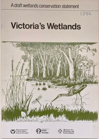
Book - Victoria's Wetlands, Dept. of Conservation, Forests & Lands, 1986
... On foot of cover: Department of Conservation, Forests... of Conservation, Forests & Lands, Department of Water Resources, Victoria ...This publication was the result of an inquiry into the state of wetland environments in Victoria. It produced a draft strategy for conservation of threatened areas in the future.An 22 page book containing maps and illustrationsThis publication was the result of an inquiry into the state of wetland environments in Victoria. It produced a draft strategy for conservation of threatened areas in the future.wetland protection, wetlands victoria, water conservation -
 The Beechworth Burke Museum
Photograph
... Department of Land & Water Conservation... by Austral Archaeology, which was done when the Department of Land... by Austral Archaeology, which was done when the Department of Land ...Taken on 25 October 1930, various houses with the Hume Dam under construction are depicted in the background. The construction of the Hume Dam took place from 1919 to 1936. At the time of construction, it was the second largest dam in the world. It was also one of the earliest civil projects developed after the Federation. Some of the Dam workers consisted of World War I veterans. Dam workers often settled their families in Mitta Junction Village and Wodonga. Archaeological surveys were completed by Austral Archaeology, which was done when the Department of Land & Water Conservation was doing work to improve Hume Dam. The archaeological report that came out of the survey recommended three sites of interest where archaeological excavation should be done: Camp Ganger’s Quarters, Stableman’s Quarters, and the Industrial Dump. The excavation uncovered artefacts. Mitta Mitta: Mitta Mitta is situated between Mount Welcome and Mount Misery. It is named after the river that explorers Hume and Hovell discovered in 1824. The town would eventually become a huge gold mining town. Mitta Mitta is called Midamodunga by the local Indigenous peoples Wodonga: Wodonga is situated on the Murray River and is part of North East Victoria. Hume and Hovell: Hamilton Hume (1979-1873) and William Hilton Hovell (1786-1875). W. H. Hovell was born in Norfolk England and Hume was born in Parramatta, New South Wales Hovell and Hume undertook an exploration journey in 1824 and thought they discovered a river, which turned out to be the Murray River. They returned home in 1825, but returned to the area in 1826 and discovered coal in the area. This photo is historically significant as it shows the Hume Dam under construction in 1930. The Dam was named after Hamilton Hume, who is an important historical figure for this area as he helped discover the area where resources were found.Sepia rectangular photograph printed unmountedReverse: 84-19-5 / 1997.3185/ Values & spillway. / When completed the wall / will be as high as the / scaffolding. [featuring trademark: kodak print]construction, houses, veterans, mitta junction village, hume dam, world war i, federation, wodonga, archaeological survey, excavation, austral archaeology, department of land & water conservation, camp ganger's quarter's, stableman's quarters, industrial dump, artefacts, mitta mitta, mount welcome, mount misery, murray river, hamilton hume, william hilton hovell, hume and hovell expedition -
 The Beechworth Burke Museum
Photograph, c1930
... Department of Land & Water Conservation... by Austral Archaeology, which was done when the Department of Land... by Austral Archaeology, which was done when the Department of Land ...Taken on 25 October 1930, various houses with the Hume Dam under construction are depicted in the background. The construction of the Hume Dam took place from 1919 to 1936. At the time of construction, it was the second largest dam in the world. It was also one of the earliest civil projects developed after the Federation. Some of the Dam workers consisted of World War I veterans. Dam workers often settled their families in Mitta Junction Village and Wodonga. Archaeological surveys were completed by Austral Archaeology, which was done when the Department of Land & Water Conservation was doing work to improve Hume Dam. The archaeological report that came out of the survey recommended three sites of interest where archaeological excavation should be done: Camp Ganger’s Quarters, Stableman’s Quarters, and the Industrial Dump. The excavation uncovered artefacts. Mitta Mitta: Mitta Mitta is situated between Mount Welcome and Mount Misery. It is named after the river that explorers Hume and Hovell discovered in 1824. The town would eventually become a huge gold mining town. Mitta Mitta is called Midamodunga by the local Indigenous peoples Wodonga: Wodonga is situated on the Murray River and is part of North East Victoria. Hume and Hovell: Hamilton Hume (1979-1873) and William Hilton Hovell (1786-1875). W. H. Hovell was born in Norfolk England and Hume was born in Parramatta, New South Wales Hovell and Hume undertook an exploration journey in 1824 and thought they discovered a river, which turned out to be the Murray River. They returned home in 1825, but returned to the area in 1826 and discovered coal in the area.This photo is historically significant as it shows the Hume Dam under construction in 1930. The Dam was named after Hamilton Hume, who is an important historical figure for this area as he helped discover the area where resources were found.Sepia rectangular photograph printed unmountedReverse: 84-19-2/ 1997.3188/ These are the four / release valves they are / not always open (illegible) this / when closed the water flows / over the spillway. [featuring trademark: kodak print] photograph number: 354construction, houses, veterans, mitta junction village, hume dam, world war i, federation, wodonga, archaeological survey, excavation, austral archaeology, department of land & water conservation, camp ganger's quarter's, stableman's quarters, industrial dump, artefacts, mitta mitta, mount welcome, mount misery, murray river, hamilton hume, william hilton hovell, hume and hovell expedition -
 The Beechworth Burke Museum
Photograph, 25 October 1930
... Department of Land & Water Conservation... by Austral Archaeology, which was done when the Department of Land... by Austral Archaeology, which was done when the Department of Land ...Taken on 25 October 1930, various houses with the Hume Dam under construction are depicted in the background. The construction of the Hume Dam took place from 1919 to 1936. At the time of construction, it was the second largest dam in the world. It was also one of the earliest civil projects developed after the Federation. Some of the Dam workers consisted of World War I veterans. Dam workers often settled their families in Mitta Junction Village and Wodonga. Archaeological surveys were completed by Austral Archaeology, which was done when the Department of Land & Water Conservation was doing work to improve Hume Dam. The archaeological report that came out of the survey recommended three sites of interest where archaeological excavation should be done: Camp Ganger’s Quarters, Stableman’s Quarters, and the Industrial Dump. The excavation uncovered artefacts. Mitta Mitta: Mitta Mitta is situated between Mount Welcome and Mount Misery. It is named after the river that explorers Hume and Hovell discovered in 1824. The town would eventually become a huge gold mining town. Mitta Mitta is called Midamodunga by the local Indigenous peoples Wodonga: Wodonga is situated on the Murray River and is part of North East Victoria. Hume and Hovell: Hamilton Hume (1979-1873) and William Hilton Hovell (1786-1875). W. H. Hovell was born in Norfolk England and Hume was born in Parramatta, New South Wales Hovell and Hume undertook an exploration journey in 1824 and thought they discovered a river, which turned out to be the Murray River. They returned home in 1825, but returned to the area in 1826 and discovered coal in the area.This photo is historically significant as it shows the Hume Dam under construction in 1930. The Dam was named after Hamilton Hume, who is an important historical figure for this area as he helped discover the area where resources were found.Sepia rectangular photograph printed unmountedReverse: 84-19-6/ 1997.3187/ The spillway [featuring trademark: kodak print] construction, houses, veterans, mitta junction village, hume dam, world war i, federation, wodonga, archaeological survey, excavation, austral archaeology, department of land & water conservation, camp ganger's quarter's, stableman's quarters, industrial dump, artefacts, mitta mitta, mount welcome, mount misery, murray river, hamilton hume, william hilton hovell, hume and hovell expedition -
 The Beechworth Burke Museum
Photograph, 25 October 1930
... Department of Land & Water Conservation... by Austral Archaeology, which was done when the Department of Land... by Austral Archaeology, which was done when the Department of Land ...Taken on 25 October 1930, various houses with the Hume Dam under construction are depicted in the background. The construction of the Hume Dam took place from 1919 to 1936. At the time of construction, it was the second largest dam in the world. It was also one of the earliest civil projects developed after the Federation. Some of the Dam workers consisted of World War I veterans. Dam workers often settled their families in Mitta Junction Village and Wodonga. Archaeological surveys were completed by Austral Archaeology, which was done when the Department of Land & Water Conservation was doing work to improve Hume Dam. The archaeological report that came out of the survey recommended three sites of interest where archaeological excavation should be done: Camp Ganger’s Quarters, Stableman’s Quarters, and the Industrial Dump. The excavation uncovered artefacts. Mitta Mitta: Mitta Mitta is situated between Mount Welcome and Mount Misery. It is named after the river that explorers Hume and Hovell discovered in 1824. The town would eventually become a huge gold mining town. Mitta Mitta is called Midamodunga by the local Indigenous peoples Wodonga: Wodonga is situated on the Murray River and is part of North East Victoria. Hume and Hovell: Hamilton Hume (1979-1873) and William Hilton Hovell (1786-1875). W. H. Hovell was born in Norfolk England and Hume was born in Parramatta, New South Wales Hovell and Hume undertook an exploration journey in 1824 and thought they discovered a river, which turned out to be the Murray River. They returned home in 1825, but returned to the area in 1826 and discovered coal in the area.This photo is historically significant as it shows the Hume Dam under construction in 1930. The Dam was named after Hamilton Hume, who is an important historical figure for this area as he helped discover the area where resources were found.Black and white rectangular photograph printer unmountedReverse: 84-20-1/ 1997.3147construction, houses, veterans, mitta junction village, hume dam, world war i, federation, wodonga, archaeological survey, excavation, austral archaeology, department of land & water conservation, camp ganger's quarter's, stableman's quarters, industrial dump, artefacts, mitta mitta, mount welcome, mount misery, murray river, hamilton hume, william hilton hovell, hume and hovell expedition -
 The Beechworth Burke Museum
Photograph, 25 October 1930
... Department of Land & Water Conservation... by Austral Archaeology, which was done when the Department of Land... by Austral Archaeology, which was done when the Department of Land ...Taken on 25 October 1930, various houses with the Hume Dam under construction are depicted in the background. The construction of the Hume Dam took place from 1919 to 1936. At the time of construction, it was the second largest dam in the world. It was also one of the earliest civil projects developed after the Federation. Some of the Dam workers consisted of World War I veterans. Dam workers often settled their families in Mitta Junction Village and Wodonga. Archaeological surveys were completed by Austral Archaeology, which was done when the Department of Land & Water Conservation was doing work to improve Hume Dam. The archaeological report that came out of the survey recommended three sites of interest where archaeological excavation should be done: Camp Ganger’s Quarters, Stableman’s Quarters, and the Industrial Dump. The excavation uncovered artefacts. Mitta Mitta: Mitta Mitta is situated between Mount Welcome and Mount Misery. It is named after the river that explorers Hume and Hovell discovered in 1824. The town would eventually become a huge gold mining town. Mitta Mitta is called Midamodunga by the local Indigenous peoples Wodonga: Wodonga is situated on the Murray River and is part of North East Victoria. Hume and Hovell: Hamilton Hume (1979-1873) and William Hilton Hovell (1786-1875). W. H. Hovell was born in Norfolk England and Hume was born in Parramatta, New South Wales Hovell and Hume undertook an exploration journey in 1824 and thought they discovered a river, which turned out to be the Murray River. They returned home in 1825, but returned to the area in 1826 and discovered coal in the area. This photo is historically significant as it shows the Hume Dam under construction in 1930. The Dam was named after Hamilton Hume, who is an important historical figure for this area as he helped discover the area where resources were found. Black and white rectangular photograph printer unmountedReverse: 1997.3145/ 84-20-2construction, houses, veterans, mitta junction village, hume dam, world war i, federation, wodonga, archaeological survey, excavation, austral archaeology, department of land & water conservation, camp ganger's quarter's, stableman's quarters, industrial dump, artefacts, mitta mitta, mount welcome, mount misery, murray river, hamilton hume, william hilton hovell, hume and hovell expedition -
Federation University Historical Collection
Report, Read Sturgess and Associates Consulting Economists et al, The Economic Significance of Grampians National Park, 1994 (and other reports), 1990-4
... of Grampians National Park for the Department of Conservation... for the Department of Conservation and Natural Resources, 1994 The Economic ....1) Grampians Surround Strategy, 1990 .2) Tourism and the Grampians Region: A Background Paper, 1990 .3) Grampians Surround Strategy and Discussion Paper, 1991 .4) The Economic Significance of Grampians National Park for the Department of Conservation and Natural Resources, 1994Notes in pencil by Mary Hollick, lecturer in Tourism at the University of Ballarat.victorian tourisim industry, tourism, halls gap, grampians, grampians national park, recreation, water production, bee keeping, arapiles, dunkeld, balmoral, pomonal, wartook, population, agriculture, water supplies, minerals, hamilton, ararat, stawell, horsham, wimmera, koorie heritage, aboriginal heritage, koorie art sites, brambuk, waterways, wannon river, wimmera river, mount william creek, rocklands reservoir, lake lonsdale, lake fyans, lake toolando, cherrypool, mirranatwa, zumstein -
Stawell Historical Society Inc
Book - Report, Grampians National Park Draft Management Plan, 1985
... . A Division of the department of Conservation, Forest and Lands.... A Division of the department of Conservation, Forest and Lands $5 ...For Public comment to National Park Service, Victoria. A Division of the department of Conservation, Forest and LandsSoft Cover with B/W Photo of aerial view of ranges of Grampians. Black taped Spine binding.$5 Barry Clugston -
 Federation University Historical Collection
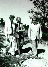
Photograph - Photograph - Black and White, Land Rehabilitation, 09/1991
... Regional Manager, Department of Conservation and Environment..., Department of Conservation and Environment; Professor John Sharpham ...A major funds injection helped to establish the Ballarat University College Centre for Land Rehabilitation. The project was co-ordinated by Dr Leigh SullivanBlack and white photograph showing three men strolling outdoors. The are (left to right) Michael Ransom (Assistant Regional Manager, Department of Conservation and Environment; Professor John Sharpham (Director of Ballarat University College) and Dr Leigh Sullivan (Co-ordinator of the National Soil Conservation Programme).ballarat university college, centre for land rehabilitation, leigh sullivan, john sharpham, michael ransom -
 Glenelg Shire Council Cultural Collection
Photograph - Photograph - Montage. Handover Ceremony of Portland Section of Great South West Walk to Department Conservation Forrest and Land, 13/04/1986
... of Great South West Walk to Department Conservation Forrest... of Great South West Walk, to the Department Conservation, Forests... West Walk, to the Department Conservation, Forests and Lands ...Glenelg Shire Council RecordsPhotographic Montage of handing over of Portland section of Great South West Walk, to the Department Conservation, Forests and Lands.Front: Bottom Right: Sticker, typed Handing over to Depatment,Conservation, Forests and Lands following inaugurul walk on City of Portland Section of the Great South West Walk. (now a complete circuit) Signature in pen Grahame McDonald 13th April 1986. -
 Bacchus Marsh & District Historical Society
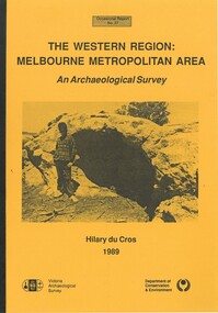
Book, The Western Region: Melbourne Metropolitan Area: An Archaeological Survey
... by Department of Conservation and Environment, Melbourne, 1990. Author... by Department of Conservation and Environment, Melbourne, 1990. Author ...This study aimed to locate and document Aboriginal archaeological sites in the western region of Melbourne. This area was defined by the study as extending out from the western suburbs of Melbourne to the Brisbane Ranges and north beyond Bacchus Marsh. The specific aim of the study was to investigate the Aboriginal archaeology of the Western Plains area in the vicinity west of Melbourne. The Bacchus Marsh, Melton and Werribee shire boundaries of the time defined the areas of the study. The study contains extensive lists of the types of artifacts found the the locations where they were found.Soft cover foolscap size book. 96 pages with b & w illustrations, images and maps (some folded). Part of Occasional reports series (Victoria Archaeological Survey) ; No. 27. Published by Department of Conservation and Environment, Melbourne, 1990. Author, Hilary Du Cros. BMDHS Loc. AR/SU5This study aimed to locate and document Aboriginal archaeological sites in the western region of Melbourne. This area was defined by the study as extending out from the western suburbs of Melbourne to the Brisbane Ranges and north beyond Bacchus Marsh. The specific aim of the study was to investigate the Aboriginal archaeology of the Western Plains area in the vicinity west of Melbourne. The Bacchus Marsh, Melton and Werribee shire boundaries of the time defined the areas of the study. The study contains extensive lists of the types of artifacts found the the locations where they were found. aboriginal australians victoria western plains, aboriginal artifacts, archaelogical sites victoria western plains, aboriginal artifacts bacchus marsh region -
University of Melbourne, Burnley Campus Archives
Plan, Alton-Hascombe Feature Survey, c. 1990
... 1 tracing paper and 2 paper copies of plan by Department... tracing paper and 2 paper copies of plan by Department ...1 tracing paper and 2 paper copies of plan by Department of Conservation, Forests and Lands, Division of Survey and Mapping, of adjoining gardens Alton and Hascombe at Mount Macedon, Victoria. Scale 1:1000. Plan of properties includes buildings, gardens and paddocks. 1 copy has significant buildings coloured.feature survey, mount macedon, gardens, alton, hascombe -
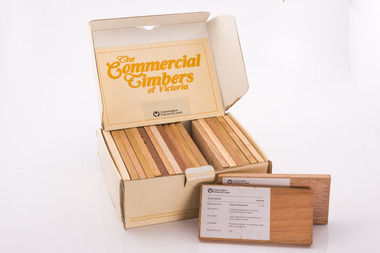 Forests Commission Retired Personnel Association (FCRPA)
Commercial timbers of Victoria, Sample Box
... by the Department of Conservation Forests and Lands. (CFL). ... by the Department of Conservation Forests and Lands. (CFL). Sample Box ...Some decades ago a card sorting set for the identification and description of Australian timbers was developed for timber species which were available commercially and were in common usage, by the Commonwealth of Australia (CSIRO, Division of Forest Products) To complement and inform this national timber set each State or Territory developed reference timber sets of representative species. The Commercial Timbers of Victoria set was Victoria’s most recent (circa 1984) expression of this Victorian timber samples were sourced from logs selected by Forest Commission of Victoria (FCV) District Foresters and milled locally. Kiln drying and machining was carried out at timber producers Row, Web and Anderson, in Port Melbourne. Labeling and boxing was done by FCV Timber Inspectors, with box and booklet design and graphics handled in-house More recent timber samples were badged as Conservation Forests & Lands, reflecting historical government restructuring in the early 1980s Info: Simon MurphyProvided the public, industry (timber and associated), and educational facilities with a reference collection of notable Victorian timbers. Initially in a reduced format from 1940-50s, with boxed sets produced from 1981 until 1984A boxed set of timber samples representing the 20 tree species that were considered to be the most notable in Victoria. The set also includes an information booklet. Each timber specimen has information on species, occurrence, uses and physical properties Produced for sale by the the FCV and later by the Department of Conservation Forests and Lands. (CFL). forests commission victoria (fcv) -
 Marysville & District Historical Society
Book - Paperback book, Secrets of the Forest-Discovering history in Melbourne's Ash Range, 1992
... Branch,/ Department of Conservation and Environment, Victoria... Places Branch,/ Department of Conservation and Environment ...A history of Melbourne's Ash forestsPaperback. Front cover has a painting on it. The painting is "Ferntree Gully in the Dandenong Ranges, 1857", painted by Eugene von Guerard.Tom Griffiths with assistance from the Historic Places Branch,/ Department of Conservation and Environment, Victoria,/ and the Monash Public History Group Stamp of the Marysville & District Historical Society Inc / P.O. Box 22 / Marysville 3779historic site, victoria, ash range, history, griffiths, tom -
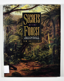 Marysville & District Historical Society
Book - Paperback book, Secrets of the Forest-Discovering history in Melbourne's Ash Range, 1992
... Branch,/ Department of Conservation and Environment, Victoria... Places Branch,/ Department of Conservation and Environment ...A history of Melbourne's Ash forestsPaperback. Front cover has a painting on it. Painting is "Ferntree Gully in the Dandenong Ranges, 1857", painted by Eugene von Guerard.Tom Griffiths with assistance from the Historic Places Branch,/ Department of Conservation and Environment, Victoria,/ and the Monash Public History Group Stamp of the Marysville & District Historical Society Inc / P.O. Box 22 / Marysville 3779historic site, victoria, ash range, history, griffiths, tom -
 Stawell Historical Society Inc
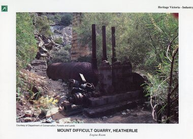
Photograph, Heatherlie Quarry -- Coloured
... on top Left. Courtesy of Department of Conservation, Forests... Left. Courtesy of Department of Conservation, Forests and Lands ...Coloured Photo Heatherlie QuarryColour Photograph of old engine and brick chimney surrounded by trees."Heritage Victoria - Industry" on top right. Unknown Logo on top Left. Courtesy of Department of Conservation, Forests and Lands. Mount Difficult Quarry, Heatherlie Engine Room On reverse information about Mount Difficult Quarry, Heatherlie, including two photgraphs.stawell grampians industry -
 Lakes Entrance Historical Society
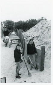
Photograph, Lakes Post Newspaper, 1992
... the Department of Conservation and Natural Resources, (L-R) Ken Judd... the Department of Conservation and Natural Resources, (L-R) Ken Judd ...Article appeared in Lakes Post 28 October 1992, 'At work on the new retaining wall leading to 90 Mile Beach, staff from the Department of Conservation and Natural Resources, (L-R) Ken Judd, Jason Bice and David Harper'.Black and white photograph of three workers, building pathway and retaining walls through the sand dunes. Coastal banksia in background. Lakes Entrance Victoriawaterfront, parks, room display -
Kew Historical Society Inc
Archive (series) - Subject File, McDonalds (Fast Food Restaurant)
... Tribunal, and the Department of Conservation and Natural Resources... Tribunal, and the Department of Conservation and Natural Resources ...Kew Historical SocietySince its foundation in 1958, members of the Kew Historical Society have been compiling and storing information about subjects relating to the history of Kew and its environs, of which this file is an example. Arranged by Secondary Values (value of records to users)Subject file created by researchers of the Kew Historical Society containing information about the McDonald's fast food franchise in High Street, Kew. The file contains a number of primary and secondary sources including newspaper cuttings, planning objections, correspondence between KHS, the City of Kew, the Administrative Appeals Tribunal, and the Department of Conservation and Natural Resources etc. The file also includes copies of the plans for the proposed restaurant. mcdonalds fast food franchises, mcdonalds restaurant -- kew (vic.), administrative affairs tribunalmcdonalds fast food franchises, mcdonalds restaurant -- kew (vic.), administrative affairs tribunal -
 Ballarat Tramway Museum
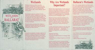
Pamphlet, City of Ballarat, "Wetlands in Ballarat", early 1990s
... contact details for the Department of Conservation and Natural... and a map. As well, provides contact details for the Department ...The pamphlet provides information about the wetland areas in the Ballarat district, in particular the ones in the North Gardens Reserve and Lake Wendouree. Provides information on the importance of the Wetlands, locations and a map. As well, provides contact details for the Department of Conservation and Natural Resources and the City of Ballaarat. Based on the spelling of the City of Ballaarat pamphlet early 1990s.Yields information about the Ballarat's wetlands within in which the tramway museum operates.Pamphlet - 4 fold DL printed in red and green ink.city of ballarat, wetlands, lake wendouree, conservation -
 Department of Energy, Environment and Climate Action
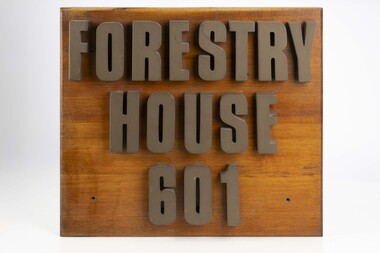
Forestry House Sign
... in the late 1980s after the formation of the Department... in the late 1980s after the formation of the Department ...Forestry House was the fist time that Forests Commission Head office staff had been housed in a purpose built building in Melbourne 601 Bourke street is on the corner of Bourke and King streets The building opened in the late 1970s but staff relocated in the late 1980s after the formation of the Department of Conservation Forests and Lands (CFL)Large wooden sigh from outside Forestry House at 601 Bourke Streetforests commission victoria (fcv), forest signs -
 Falls Creek Historical Society
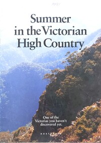
Magazine - Summer in the Victorian High Country 1991
... Commission Victoria and the Department of Conservation..., the RACV, the Alpine Resorts Commission Victoria and the Department ...This brochure is part of the marketing program for the Victorian High Country in Northeast Victoria. It contains information on several locations. The cover bears an image of the mountains, the title and the slogan "One of the Victorias you haven't discovered yet". The brochure was jointly sponsored by the Victorian Tourism Commission, the RACV, the Alpine Resorts Commission Victoria and the Department of Conservation and the Environment.This item is important as it documents promotions for a popular region of Victoria surrounding Falls Creek.An A4 sized magazine titled 'Summer in the Victorian High Country" featuring images and text.victorian high country, falls creek marketing -
 Stawell Historical Society Inc
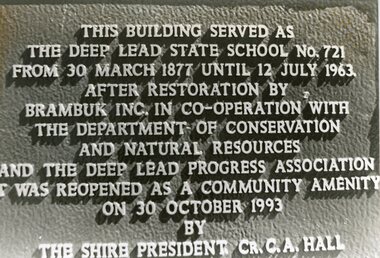
Photograph, Deep Lead Dedication Plaque
... by Brambuk Inc. In Co-operation with the Department of Conservation... with the Department of Conservation ad Natural Resources and the Deep Lead ...B/W Photp Bronze PlaqueThe Building served as the Deep Lead State School No. 721 from 30 March 1877 Until 12 July 1963. After Restoration by Brambuk Inc. In Co-operation with the Department of Conservation ad Natural Resources and the Deep Lead Progress Association it was reopened as a Community Amenity on 30 October 1993.'By the Shire President Cr. C.A. Hall.deep lead school, education -
Federation University Historical Collection
Reports, Unidentified Mammal Report, 1970-1990, 1970-1990
... of Information request made to the Department of of Conservation, Forests... of Information request made to the Department of of Conservation, Forests ...The folder or correspondence is the result of a Freedom of Information request made to the Department of of Conservation, Forests and Lands in 2011. The folder was collected for research being conducted by David Waldron.Folder of reports relating to "Big Cats", Thylacines, and other large predators sightings australian mythical animals collection, david waldron, thylacine, sassafras, peter monhorst, jodie hoey, kelvin smith, traralgon south, gormondale, bridgewater, g. mcclure, whorouly, albury, jim walker, andrea westcott, john dawson, nicole walsh, grampians, eddy scott, talbot, lancefield, kalorama, inglewood, gavin cerini, dereel, rosemary fernandez, brian walters, alexandra, unidentified mammel, romsey, bill butterworth, flowerdale, bob hoare, trafalgar, lyn demopolis, broadford, green gully, ian weir, noel pascoe, bruce carter, mount stirling, andrea cooper, stawell, yvonne shepherd, red hills, halls gap, jill reid, puma, w.r.c. hill, caelli -
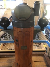 Queenscliffe Maritime Museum
Instrument - Binnacle Compass
... June 1942. The George Kermode was scuttled by the Department... June 1942. The George Kermode was scuttled by the Department ...Built in 1914 by Fleming and Ferguson in Paisley Scotland as Sir William Matthews for the Ceylon Government, she was a twin screwed steam bucket dredge. She was purchased from the Western Australian Government by the Melbourne Harbour Trust on 10 October 1941. After an extensive overhaul, the vessel was renamed the George Kermode and commenced operation in Victorian waters on 22 June 1942. The George Kermode was scuttled by the Department of Conservation, Forests and Land off Phillip Island on the 1 April 1976 as part of an artificial reef program. This vessel was used to dredge the Port Phillip channels from 1942 and is of cultural significance to Queenscliffe.Binnacle compass from the 'George Kermode'Compass No. 3127N Sestrel Type 89098bucket dredge, port phillip, melbourne harbour trust -
 Orbost & District Historical Society
map/poster, Victorian Government Printer, 22.4.1926
... Ministries to form the Department of Conservation, Forests and Land... Ministries to form the Department of Conservation, Forests and Land ...The Department of Crown Lands and Survey was originally established in 1857 as part of the Board of Land and Works. In 1964 it ceased to be controlled by the Board. The Department functioned for almost twenty more years before being combined with other Ministries to form the Department of Conservation, Forests and Land. It was responsible for the management of the State's Crown land and pastoral estates. This map was used by Don Mehlert after 1928. The VERMIN AND NOXIOUS WEEDS ACT 1928 was an Act to consolidate the Law relating relating to Vermin and Noxious Weeds. E. J. E. G. Pemberton who published this poster was Superintendent of Field Staff, Dept. of Lands and Survey. This map and posters are significant records of early settlement history in Murrangower, between Cabbage Tree and Orbost,A paper map of Murrangower showing settlement subdivisions. This is glued onto the back of four overlapping cloth poster of "Notices of Vermin Destruction". All print is black."DON MEHLERT" in black pen. Pike's block shaded in blue. School site marked in blue pencil. on poster "MURRANGOWAR" along side.map-murrangower poster-vermin-and-noxious-weeds murrangower-settlement