Showing 463 items
matching doncaster road
-
 Whitehorse Historical Society Inc.
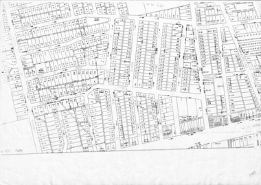
Map, Cadastral map, ca 1955
... doncaster east road... dunlavin road doncaster east road harrison street william street ...Cadastral map showing house and lot numbers (ca 1955) in Mitcham.plans, ormond avenue, mitcham, hardwood court, bruce street, page street, victoria avenue, mitcham road, whitehorse road, dunlavin road, doncaster east road, harrison street, william street, alexander street, fellows street, peel street, milne street, albert street, edward street, shirley court, burnett street, haines street -
 Whitehorse Historical Society Inc.
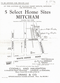
Document, 5 Select Homes Sites Mitcham, 16/11/1929 12:00:00 AM
... doncaster east road... mcdowell street doncaster east road whitehorse road coghill ...Auction of land in Mitcham.Auction of land in Mitcham. Includes schetch map of locations and names of purchasersAuction of land in Mitcham. auction, station front estate, mitcham road, mcdowell street, doncaster east road, whitehorse road, coghill & haughton estate agents, drake & co estate agents, roeszler, norman george, edith mary, reid harrison street -
 Whitehorse Historical Society Inc.
Document, Descendents of Albert Edward Henry Charlesworth, 1/10/2002 12:00:00 AM
... Doncaster East Road... Doncaster East Road Mitcham Harrison Street Mitcham Barrett Street ...Family tree of Albert Henry Charlesworth, includes plan of Charlesworth Estate, MitchamFamily tree of Albert Henry Charlesworth, includes plan of Charlesworth Estate, MitchamFamily tree of Albert Henry Charlesworth, includes plan of Charlesworth Estate, Mitchamcharlesworth, albert edward henry, charlesworth, albert roy, family trees, charlesworth family, mcintyre family, collins family, wallace family, charlesworth estate, mitcham, doncaster east road, mitcham, harrison street, mitcham, barrett street, mitcham, quarry road, mitcham -
Whitehorse Historical Society Inc.
Article, Housing density concern, 1993
... Doncaster East Road... Planning City of Nunawading Mitcham Doncaster East Road Mitcham ...The future of streets in North-east Mitcham has been in question for three years.The future of streets in North-east Mitcham has been in question for three years. But a new proposal to rezone the area for high density housing has been opposed by two Mitcham residents who think the density proposal is too high for the area.The future of streets in North-east Mitcham has been in question for three years. town planning, city of nunawading, mitcham, doncaster east road, mitcham, harrison street, mitcham, mcdowall street, mitcham -
Whitehorse Historical Society Inc.
Document, Biography of Dr Francis John Drake, 1/11/1983 12:00:00 AM
... Doncaster East Road... Road Mitcham Doncaster East Road Mitcham McDowall Street ...A brief biography of Doctor Francis John Drake - medical practitioner and early land owner in the Mitcham area.A brief biography of Doctor Francis John Drake - medical practitioner and early land owner in the Mitcham area. Compiled by Andrew Hillier. Includes copies of Dr Drake's Marriage Certificate, entry in Register of Deaths and a portrait.A brief biography of Doctor Francis John Drake - medical practitioner and early land owner in the Mitcham area. drake, francis john, dr, park road, mitcham, heads road, donvale, mitcham north, whitehorse road, mitcham, elizabeth street, mitcham, station street, mitcham, colombo street, . mitcham, mitcham road, mitcham, doncaster east road, mitcham, mcdowall street, mitcham -
 Melbourne Tram Museum
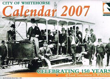
Ephemera - Calendar, City of Whitehorse, "City of Whitehorse Calendar 2007 - Celebrating 150 Years", 2006
... Melbourne Tram Museum 8 Wallen Road Hawthorn melbourne ...Calendar - 16 pages - card cover, full colour, titled "City of Whitehorse Calendar 2007 - Celebrating 150 Years", featuring a photograph of the Box Hill - Doncaster featuring a photograph of the opening of the Box Hill to Doncaster tramway of 1889 along with many other historical photographs. Includes a photo in Oct. of the Station St - Whitehorse Road intersection with a Box Hill to Blackburn bus. Marks on the road look like a tram track that has been buried, but just marks on the road. Gives the photo credits.trams, tramways, city of whitehorse, box hill, doncaster, whitehorse road -
 Melbourne Tram Museum
Document - Report, Australian Electric Traction Association (AETA), Set of 6 options for Doncaster Light Rail Line, 1991
... Freeway/Doncaster Road 2 - Light rail to Mitcham Road/Springvale... Freeway/Doncaster Road 2 - Light rail to Mitcham Road/Springvale ...In 1991, the Australian Electric Traction Association (AETA) produced 7 different options to provide public transport to the Doncaster area. See reference for background to the proposals. Six of the seven options have been found and collected. Each option provides a summary, costing based in a scope of works. The Options were: 1 - Light Rail to Doncaster Shoppingtown via Eastern Freeway/Doncaster Road 2 - Light rail to Mitcham Road/Springvale Road 3 - High-performance train to Doncaster Shoppingtown via Victoria Park station Eastern Freeway/Doncaster Road 4 - Heavy rail to Doncaster Shoppingtown via Eastern Freeway to Bulleen Road and underground to Shoppingtown 5 - Heavy Rail to Blackburn Road/George St East Doncaster 7 - Extension of the Camberwell Tram (72) along Burke Road from Cotham Road to Doncaster Road. Out of all the studies, nothing happened.Yields information about the early 1990s proposal to provide public transport to the Doncaster area.Set of 6 reports or options printed on A4 paper, stapled in top left hand corner.tramcars, tramways, aeta, new tramways, doncaster, railways, light rail -
 Kew Historical Society Inc
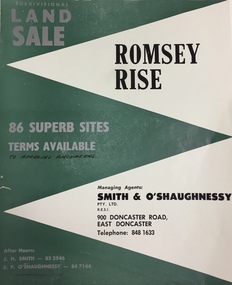
Plan - Subdivision Plan, Romsey Rise, Doncaster East
... Doncaster. Roads identified in the plan include: George Street... estate brochure for a land sale of 86 sites in East Doncaster ...Real estate brochure for a land sale of 86 sites in East Doncaster. Roads identified in the plan include: George Street, Dennert Street, Worthing Avenue, Sandhurst Street, Belinda Crescent, and Romsey Rise.Historic subdivision plan of a Doncaster East EstateFour page colour real estate brochure including on page 2 a subdivision plan for the Romsey Rise estate in East Doncaster. This record also includes a separate price list for the lots.real estate plans, subdivision plans - doncaster east, romsey rise estate - doncaster east (vic) -
 Whitehorse Historical Society Inc.
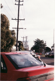
Photograph, Whitehorse Road, 1/06/1999 12:00:00 AM
... Doncaster East Road looking toward Mitcham Road.... photo of Whitehorse Road, Mitcham, opposite Doncaster East Road ...Coloured photo of Whitehorse Road, Mitcham, opposite Doncaster East Road looking toward Mitcham Road.whitehorse road, overhead powerlines -
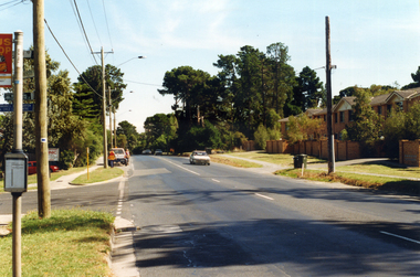
 Whitehorse Historical Society Inc.
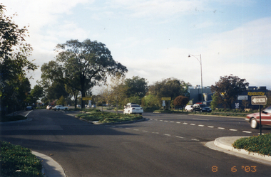
Photograph, Whitehorse Road, Mitcham
... the corner of Doncaster East Road. Taken 2003... of Whitehorse Road looking east from the corner of Doncaster East Road ...Coloured photo of Whitehorse Road looking east from the corner of Doncaster East Road. Taken 2003whitehorse road, mitcham -
 Kew Historical Society Inc
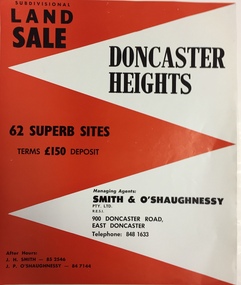
Plan - Subdivision Plan, Doncaster Heights
... of 900 Doncaster Road for the sale of the '65 superb sites... Doncaster Road for the sale of the '65 superb sites ...Real estate brochure produced for Smith & O'Shaughnessy of 900 Doncaster Road for the sale of the '65 superb sites' in the Doncaster Heights Estate. Streets with lots for sale include: Church Road, Norfolk Circuit, and Hampshire Road.Historic subdivision planFour-page colour real estate brochure issued for the sale of the Doncaster Heights Estate. The inside pages include a street plan with the numbered lots.subdivision plans - doncaster, doncaster heights estate -
 Kew Historical Society Inc
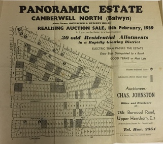
Plan - Subdivision Plan, Panoramic Estate, Camberwell North (Balwyn), 1939, 1939
... , Macedon Avenue, The Moor, Sunburst Avenue, Doncaster Road, Fortuna... Avenue, The Moor, Sunburst Avenue, Doncaster Road, Fortuna Avenue ...Subdivision plan advertised as the Panoramic Estate, Balwyn, showing lots for sale in the following streets: Bulleen Road, Macedon Avenue, The Moor, Sunburst Avenue, Doncaster Road, Fortuna Avenue, Longview Road, The Nook, and Touring Avenue.Single page subdivision plan of the Panoramic Estate in Camberwell North (Balwyn); offered for sale in 1939Nilsubdivision plans - balwyn (vic), panoramic estate - camberwell north - balwyn (vic) -
 Kew Historical Society Inc
Plan - Subdivision Plan, Houghton Street & Buchanan Avenue, Balwyn North, ca. 1906
... by Houghton Street, Doncaster Road, Buchanan Avenue and Maud Street... Street, Doncaster Road, Buchanan Avenue and Maud Street, North ...The Kew Historical Society collection includes almost 100 subdivision plans pertaining to suburbs of the City of Melbourne. Most of these are of Kew, Kew East or Studley Park, although a smaller number are plans of Camberwell, Deepdene, Balwyn and Hawthorn. It is believed that the majority of the plans were gifted to the Society by persons connected with the real estate firm - J. R. Mathers and McMillan, 136 Cotham Road, Kew. The Plans in the collection are rarely in pristine form, being working plans on which the agent would write notes and record lots sold and the prices of these. The subdivision plans are historically significant examples of the growth of urban Melbourne from the beginning of the 20th Century up until the 1980s. A number of the plans are double-sided and often include a photograph on the reverse. A number of the latter are by noted photographers such as J.E. Barnes.A hand-drawn subdivision plan listing six blocks bounded by Houghton Street, Doncaster Road, Buchanan Avenue and Maud Street, North Balwyn. Written on the plan of subdivision are the lot numbers, the dimensions of the blocks and the price at which two lots were for sale or had been sold for.subdivision plans - balwyn -
 Whitehorse Historical Society Inc.
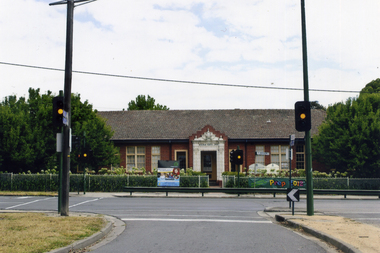
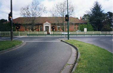
Photograph, Mitcham Primary School No 2904
... The traffic lights are at the intersection of Mitcham and Doncaster... are at the intersection of Mitcham and Doncaster East Roads - 2012 Mitcham Primary ...On 24th September 1888 a wooden state school opened on land purchased on the north west corner of Whitehorse and Mitcham Roads. In 1890 a contract was let for the construction of a one-room brick school house on that site. By 1907 student numbers had risen to 120 so the Church of Christ Hall was leased for 10/- a week. By 1922 cracks had appeared, plaster had fallen in the school and both the Brittania Street Scout Hall and the Methodist Church has been leased for classrooms. On 10/4/1930, a new school, to be occupied by the upper grades was opened in its present location.Coloured picture of Mitcham Primary School No 2904 The traffic lights are at the intersection of Mitcham and Doncaster East Roads - 2012mitcham primary school no. 2904, schools -
 Ringwood and District Historical Society
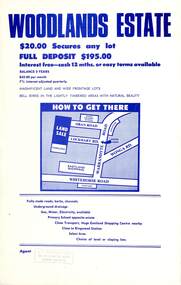
Flyer, Land Sale Advertisement - Woodlands Estate, North Ringwood, Victoria - circa 1970
... Subdivision includes Oban Road, Terrigal Close, Dorelaw..., 264 Doncaster Road, North Balwyn. Double sided single-page ...Double sided single-page advertisement for land sale with locality map and layout of Woodlands Estate subdivision in North Ringwood, with summary of local features and services. No indication of date of flyer other than post-Eastland Shopping Centre opening in 1967.Subdivision includes Oban Road, Terrigal Close, Dorelaw Drive (later Melview Drive), Naroo Court, and Barook Court. Agent's rubber stamp imprint - H.C. Walton & Son, 264 Doncaster Road, North Balwyn. -
 Kew Historical Society Inc
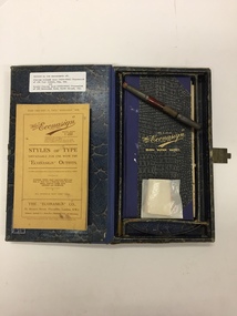
Equipment, The Econasign Co Ltd, The "Econasign" Bijou Super Outfit, 1929-1947
... of 283 Doncaster Road, North Balwyn, Vic."... Charles Wood (1920-1948) Pharmacist of 283 Doncaster Road, North ...Econasign kits were aimed at small businesses who could use the transparent stencils for the manufacturing of “showcards, price tickets, posters, labels, etc…..by a simple operation of printing by means of transparent stencils.Intact printing kit used in a notable Kew pharmaceutical business.A kit of printing equipment for commercial small display signage. Box and contents produced by the "Econasign" Co. Ltd. 137 Victoria Street, London S.W.1. The box includes a booklet, sample blank paper signs, a brush, and a book of plastic templates. The latter indicates that the kit was distributed by an Australian Agent - J. Raeburn Miller, 8 Bank of NSW Chamber, 280 Castlereagh St., SydneyTyped label on interior: "Donated by the descendants of Charles Gilbert Wood (1891-1948) Pharmacist of 235 High Street, Kew, Vic, / and / Donald Charles Wood (1920-1948) Pharmacist of 283 Doncaster Road, North Balwyn, Vic."econasign, pharmacy printing equipment, charles gilbert wood, donald charles wood -
 Kew Historical Society Inc
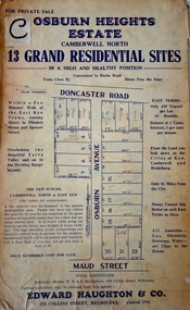
Plan - Subdivision Plan, Osburn Heights Estate, 1938
... of subdivisions running between Doncaster Road and Maud Street, including... of subdivisions running between Doncaster Road and Maud Street, including ...Edward Haughton & Co, in promoting the Osburn Heights Estate in what is now Balwyn North, attempted to capitalize on the subdivision’s proximity to East Kew. One section of the plan is includes the text: ‘The New Suburb: Camberwell North or East Kew (the names are synonymous)’. The Osburn Heights subdivision was part of a series of subdivisions running between Doncaster Road and Maud Street, including the ‘Pointed Firs Estate’ (MAP.0010). This subdivision included 13 ‘grand residential sites’ for sale in Doncaster Road, Maud Street and Osburn Avenue.subdivision plans - camberwell north, osburn heights estate -
 Kew Historical Society Inc
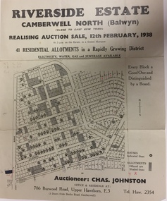
Plan - Subdivision Plan, Riverside Estate, Camberwell North (Balwyn), 1938, 1939
... , Walbundry Avenue, Inverness Way, Bulleen Road and Doncaster Road...., Inverness Way, Bulleen Road and Doncaster Road. Riverside Estate ...This subdivision known as the Riverside Estate wa sone of the largest and most significant in Balwyn's history.Subdivision Plan for 41 lots within the wider Riverside Estate in Camberwell North, now Balwyn, in February 1938. The auction featured lots in Burke Road, The Boulevard, Mt View Road, Wattle Avenue, Kyora Parade, Cascade Street, Riverside Avenue, Walbundry Avenue, Inverness Way, Bulleen Road and Doncaster Road.Allotments for sale are shaded grey on the map. Certain lots have an H in a circle. These are presumably where houses had already been constructed.subdivision plans - balwyn (vic), riverside estate - balwyn (vic) -
Whitehorse Historical Society Inc.
Document, Fire demolished RWM Hall & Bloom Timber Merchant's property, 1990
... . The property was in Whitehorse Road opposite Doncaster East Road... Doncaster East Road, Mitcham, 1921 - 1930s. Describes the operation ...Fire demolished RWM Hall & Bloom Timber Merchant's propertyRecollections of a fir at RWM Hall & Bloom- timber merchants. Box makers, supplied by former employee Mr W. Grundy. The property was in Whitehorse Road opposite Doncaster East Road, Mitcham, 1921 - 1930s. Describes the operation of the plant.Fire demolished RWM Hall & Bloom Timber Merchant's propertytimber merchants, hall, r.w.m. & bloom, whitehorse road, mitcham, grundy, w, bloom, alfred -
 Kew Historical Society Inc
Plan - Subdivision Plan, Pointed Firs Estate, 1936
... and Heidelberg. The 36 lots advertised for sale faced Doncaster Road... Doncaster Road, Houghton Street, Maud Street and Thackray Street ...The Kew Historical Society collection includes almost 100 subdivision plans pertaining to suburbs of the City of Melbourne. Most of these are of Kew, Kew East or Studley Park, although a smaller number are plans of Camberwell, Deepdene, Balwyn and Hawthorn. It is believed that the majority of the plans were gifted to the Society by persons connected with the real estate firm - J. R. Mathers and McMillan, 136 Cotham Road, Kew. The Plans in the collection are rarely in pristine form, being working plans on which the agent would write notes and record lots sold and the prices of these. The subdivision plans are historically significant examples of the growth of urban Melbourne from the beginning of the 20th Century up until the 1980s. A number of the plans are double-sided and often include a photograph on the reverse. A number of the latter are by noted photographers such as J.E. Barnes.An almost identical plan of the ‘Pointed Firs Estate’ is in the State Library of Victoria. The plan unusually uses a photograph to show the panoramic views from the Estate. A prospective purchaser could expect to look across the Yarra Valley to Eaglemont and Heidelberg. The 36 lots advertised for sale faced Doncaster Road, Houghton Street, Maud Street and Thackray Street in Balwyn North.subdivision plans - balwyn, pointed firs estate -
 Whitehorse Historical Society Inc.
Photograph, Mitcham Primary School, 1/10/2000 12:00:00 AM
... , Mitcham taken from traffic lights on Doncaster East Road. Fence... from traffic lights on Doncaster East Road. Fence erected 2000 ...Coloured photograph of Mitcham Primary School, Mitcham Road, Mitcham taken from traffic lights on Doncaster East Road. Fence erected 2000.mitcham primary school, no. 2904 -
Whitehorse Historical Society Inc.
Document, Eastern Arterial Road, 1986
... Eastern Corridor Road Development (ECORD) Doncaster... and Streets Eastern Corridor Road Development (ECORD) Doncaster ...Eastern Corridor Road Development (ECORD) Doncaster to Ringwood. Road Construction Authority 1986eastern freeway, ringwood bypass, roads and streets -
Kew Historical Society Inc
Plan - Pointed Firs Estate, Camberwell North, 1936
... in Doncaster Road, Thackeray Street, Houghton Street, an dMaud Street. ... lots in Doncaster Road, Thackeray Street, Houghton Street ...Subdivision plans and real estate flyers/brochures reveal a number of aspects of urban development and history. The Kew Historical Society's collection of these plans, as well as advertisements extracted from magazines, cover key aspects of community development and architectural history of Kew and Kew Eat as well as surrounding suburbs. While most of the plans in the collection were gifted to the Society by the former City of Kew, a number of other plans and advertisements have been donated by individuals, of which this is an example.Original multi-page sales brochure of the Pointed Firs Estate, advertised as located in Camberwell North, but now in Balwyn North. The 4-page bifold brochure includes promotional material as well as a detailed plan of the 28 lots for sale, a photograph of the locality with the plan overlaying it, as well as aerial photos and street views. The estate included lots in Doncaster Road, Thackeray Street, Houghton Street, an dMaud Street. pointed firs estate -- balwyn north, subdivisions -- balwyn north (vic.) -
 Melbourne Tram Museum
Photograph - Digital Image, Kevin O'Reilly, "Kew Burke Rd' looking at the East Kew Tram terminus, c1925
... at the intersection of High St, Burke, Kilby and Doncaster Roads. We... at the intersection of High St, Burke, Kilby and Doncaster Roads. We ...Image from CD (Compact Diskette for use in computers) - see Reg Item 135. Image titled "Kew Burke Rd' on CD, of looking at the East Kew Tram terminus with the city skyline in the background, c1925. Photo published in the Bellcord No. 16, Oct. 2012. From the article with the photograph; The terminus was located at the intersection of High St, Burke, Kilby and Doncaster Roads. We are at the outer edges of Melbourne’s suburbia at the time, unlike the current tram terminus of today. Burke Road, north of Doncaster Road is clearly under construction in preparation for the new river crossing. The vacant block of land in the foreground will remain so for another ten years or so. In 1960 the new Dickens Supermarket was built on this site and the intersection became known locally as Dickens Corner. The narrow track on the left hand side of the photo is Doncaster Road. The tram at the terminus is a straight-sill single trucker of one of the G, K, Q or R classes. It is finished in the late MMTB chocolate and cream livery. A cable grip car body has been placed as a tram shelter at the terminus. The church was subsequently relocated to Francis Street Yarraville where it still stands today as a private residence. Behind the large hedge on the south side of High Street is Smith’s Dairy. Part of this land would be sold to the MMTB for a planned new tram depot Behind the large hedge on the south side of High Street is Smith’s Dairy. Part of this land would be sold to the MMTB for a planned new tram depot but by the early 1960s it was transferred to the Education Department for construction of the Kew High School. The last portion of the dairy closed in the 1970s.trams, tramways, kew, burke rd, east kew, doncaster rd -
Kew Historical Society Inc
Plan - Tramway Estate, Camberwell North, 1937
... by Doncaster Road, Burke Road, Marwan Avenue, Maud Street, Severn... by Doncaster Road, Burke Road, Marwan Avenue, Maud Street, Severn ...Subdivision plans and real estate flyers/brochures reveal a number of aspects of urban development and history. The Kew Historical Society's collection of these plans, as well as advertisements extracted from magazines, cover key aspects of community development and architectural history of Kew and Kew Eat as well as surrounding suburbs. While most of the plans in the collection were gifted to the Society by the former City of Kew, a number of other plans and advertisements have been donated by individuals, of which this is an example.Single page subdivision plan listing properties for sale in the Tramways Estate, Camberwell North. The large estate was bounded by Doncaster Road, Burke Road, Marwan Avenue, Maud Street, Severn Street, and extended over Glass's Creek at Mayland's Avenue. Within the plan, lots 3 to 342 are listed as lots. The plan includes annotations in ink indicating the prices realised by a number of lots. A key explains that lots with an 'H' represent a house, whereas the 37 shaded lots represent those being offered by this agent. subdivision plans -- camberwell (vic.), tramways estate -
Kew Historical Society Inc
Plan - Camberwell Panorama Estate, 1923
... by Bulleen Road, The Nook, Fortuna Avenue, and Doncaster Road. Other... bounded by Bulleen Road, The Nook, Fortuna Avenue, and Doncaster ...Subdivision plans and real estate flyers/brochures reveal a number of aspects of urban development and history. The Kew Historical Society's collection of these plans, as well as advertisements extracted from magazines, cover key aspects of community development and architectural history of Kew and Kew Eat as well as surrounding suburbs. While most of the plans in the collection were gifted to the Society by the former City of Kew, a number of other plans and advertisements have been donated by individuals, of which this is an example.Promotional brochure for the Camberwell Panorama Estate. The four page bifold handout advertises 216 home sites bounded by Bulleen Road, The Nook, Fortuna Avenue, and Doncaster Road. Other streets in the subdivision include: Sunburst Avenue, The Moor, and Macedon Avenue. The brochure has been damaged at some time in the past and so masking tape obscures the tram on page 1. Page 2 includes the plan of the subdivision, page 3 information about the site and a locality plan, while page 4 includes photographs and terms of sale. subdivision plans -- balwyn north (vic.), camberwell panorama estate -
Whitehorse Historical Society Inc.
Document, Eastern Corridor Road Development, 1/09/1986 12:00:00 AM
... of Eastern Corridor Road - Doncaster to Ringwood. Holdings: No 1... Corridor Road - Doncaster to Ringwood. Holdings: No 1 September ...Ministry of Transport Bulletins about development of Eastern Corridor RoadMinistry of Transport Bulletins about development of Eastern Corridor Road - Doncaster to Ringwood. Holdings: No 1 September 1986; no.3 June 1987.Ministry of Transport Bulletins about development of Eastern Corridor Roadroads and streets, eastern freeway, victoria. ministry of transport, mullum mullum creek -
Whitehorse Historical Society Inc.
Map, Blackburn and Doncaster, 1950, 1950
... , Main Road, Doncaster..... Advertisement for G.S. Grover, Real Estate Agent, Main Road, Doncaster ...Map of part of Blackburn and Doncaster from Morgan's Street Directory, 1950. Advertisement for G.S. Grover, Real Estate Agent, Main Road, Doncaster.Map of part of Blackburn and Doncaster from Morgan's Street Directory, 1950. Advertisement for G.S. Grover, Real Estate Agent, Main Road, Doncaster.Map of part of Blackburn and Doncaster from Morgan's Street Directory, 1950. Advertisement for G.S. Grover, Real Estate Agent, Main Road, Doncaster.maps, blackburn, grover, g.s., doncaster -
 Whitehorse Historical Society Inc.
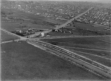
Photograph, Prior to Widening of Mitcham Road, 1/02/2000 12:00:00 AM
... Doncaster. Hedge End Road on left, Wrendale Drive on right. Prior... Doncaster. Hedge End Road on left, Wrendale Drive on right. Prior ...Coloured photograph of Mitcham Road looking towards Doncaster. Hedge End Road on left, Wrendale Drive on right. Prior to construction of widening of Mitcham Road.mitcham road, donvale, hedge end road, mitcham, wrendale drive -
Kew Historical Society Inc
Plan - Burke Road Junction Estate, East Kew, 1940
... of Burke Road and High Street/Doncaster Road. The dairy includes... of Burke Road and High Street/Doncaster Road. The dairy includes ...Subdivision plans and real estate flyers/brochures reveal a number of aspects of urban development and history. The Kew Historical Society's collection of these plans, as well as advertisements extracted from magazines, cover key aspects of community development and architectural history of Kew and Kew Eat as well as surrounding suburbs. While most of the plans in the collection were gifted to the Society by the former City of Kew, a number of other plans and advertisements have been donated by individuals, of which this is an example.Original 4-page bifold brochure advertising the Burke Road Junction Estate in Kew East. Advertised for sale in 1940, the estate comprised 16 'Central Allotments' fronting High Street, Kilby Road, and Glass Street. Pages 1 & 4, the front and back covers, includes a panoramic photograph of the junction which features a number of shops still extant, but also with buildings long demolished and redeveloped. These include the petrol station and the dairy on the southeast and southwest corners of Burke Road and High Street/Doncaster Road. The dairy includes a statue of a cow on its roof. Pages 2 & 3 include a detailed plan of the estate. subdivisions -- kew east (vic.), burke road junction estate