Showing 79 items
matching early dwelling
-
 Eltham District Historical Society Inc
Photograph, Liz Pidgeon, Hassall's Gallery Bazaar, 1215 Main Road, Eltham, 25 March 2014, 25 March 2014
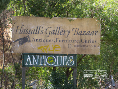
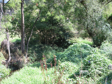
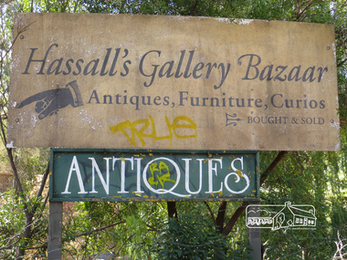
This is the site of the first roadside art gallery - Hassall's Roadside Gallery created by the artist son of an artist. Ian Hassall was the son of John Hassall who was among and may have been the first of the British poster artists. The gallery opened Saturday July 14, 1962 at 1215 Main road, Eltham by the director of the National Gallery of Victoria, Eric Westbrook. Situated on the left hand side of the main road, about a mile and a half beyond Eltham, towards Research, near Coleman's Corner at the intersection of Wattletree Road. The property has remnants of a stone quarry, probably for the purpose of gaining stone for local road making. Paintings were hung on screens and removed at night for safety. Large pedestals displayed sculpture and jewellery. All types of hand made art work was displayed. Access to the exhibition and grounds was slightly lower than the level of the road. They were encircled by a narrow little moat formed by a small tributary of the Diamond Creek accessed by a small well built stone bridge built by Ian Hassall with local stone. The Gallery later became known as Hassall's Gallery Bazaar antiques, furniture, curios bought and sold. It operated through to the early 1990s. The property has been derelict and neglected for some years. At one stage a shipping container sat near the entrance. This series of ten photographs illustrate the extent of the vegetation which has taken over the land, evidence of rubbish and a possible fire. In July 2017, planning permission was sought from the Shire of Nillumbik for buildings and works to construct a dwelling and associated vegetation removal. (source planningalerts.org.au)Born Digitaleltham, main road, hassall's gallery bazaar -
 Eltham District Historical Society Inc
Photograph, Liz Pidgeon, Hassall's Gallery Bazaar, 1215 Main Road, Eltham, 25 March 2014, 25 March 2014
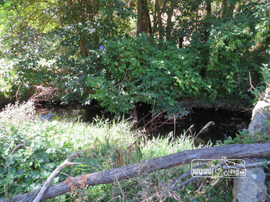
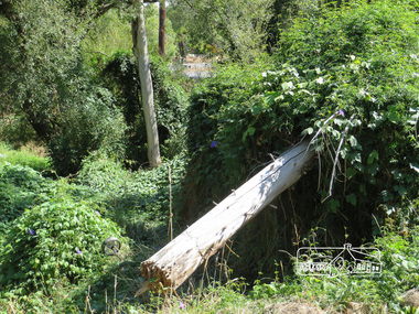
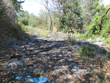
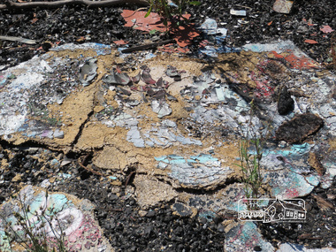
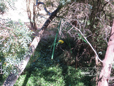
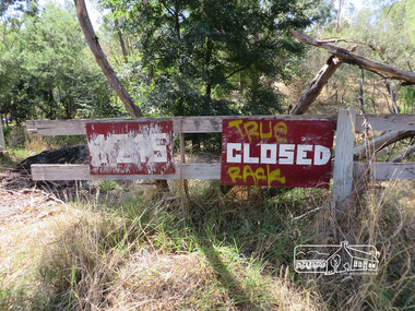
This is the site of the first roadside art gallery - Hassall's Roadside Gallery created by the artist son of an artist. Ian Hassall was the son of John Hassall who was among and may have been the first of the British poster artists. The gallery opened Saturday July 14, 1962 at 1215 Main road, Eltham by the director of the National Gallery of Victoria, Eric Westbrook. Situated on the left hand side of the main road, about a mile and a half beyond Eltham, towards Research, near Coleman's Corner at the intersection of Wattletree Road. The property has remnants of a stone quarry, probably for the purpose of gaining stone for local road making. Paintings were hung on screens and removed at night for safety. Large pedestals displayed sculpture and jewellery. All types of hand made art work was displayed. Access to the exhibition and grounds was slightly lower than the level of the road. They were encircled by a narrow little moat formed by a small tributary of the Diamond Creek accessed by a small well built stone bridge built by Ian Hassall with local stone. The Gallery later became known as Hassall's Gallery Bazaar antiques, furniture, curios bought and sold. It operated through to the early 1990s. The property has been derelict and neglected for some years. At one stage a shipping container sat near the entrance. This series of ten photographs illustrate the extent of the vegetation which has taken over the land, evidence of rubbish and a possible fire. In July 2017, planning permission was sought from the Shire of Nillumbik for buildings and works to construct a dwelling and associated vegetation removal. (source planningalerts.org.au)Born Digitaleltham, main road, hassall's gallery bazaar -
 Victoria Police Museum
Police Stations (Apollo Bay)
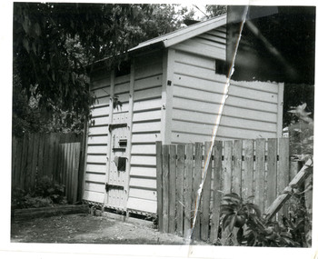
Apollo Bay is a coastal town in southwestern Victoria. It is situated on the eastern side of Cape Otway, along the edge of the Barham River and on the Great Ocean Road, in the Colac Otway Shire. The original township was surveyed in 1853 and named Middleton. In 1881 the town was renamed Krambruk which was changed to Apollo Bay in 1898. The Krambruk Police Station was opened on 7 March 1888 in the Southern District on land opposite the site of the current Mechanics' Institute and changed its name to the Apollo Bay Police Station on 1 September 1990. It came under the Barwon District in 1948 and "Lima" Western District from 4 March 1990. In 1930 the police station was located to 29 Nelson Street. It was a seven-roomed weather-board dwelling on three-quarters of an acre of land. It consisted of six rooms of pine, lined and painted; one pantry; one bathroom and wash-house; one hall; one office and one W.C.. There was stabling for one horse and one cell for prisoners. It was staffed by one Mounted Constable. In the early 1970s land was acquired at 31 Nelson Street and a new police station was constructed. This was a three-roomed brick building with a cell block at the rear. By the time it closed in 2005 it had been extended twice. On 17 November 2006 the current Apollo Bay Police Station opened in its current location at 35a Nelson Street, on the corner of Cartwight Street). Outside the peak summer season, the station is open 16 hours per day and staffed by one sergeant and five other members. 3 black & white photos and 2 coloured photospolice stations; apollo bay police station -
 Eltham District Historical Society Inc
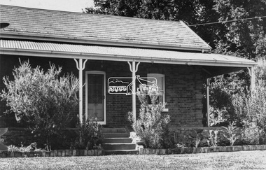
Negative - Photograph, Leader Publishing Co, Wingrove Cottage, c.1970
Wingrove Cottage is historically significant for its long association with Charles Wingrove, a prominent figure in Victorian local government, as secretary to the Eltham District Road Board and Shire Council from 1858 to 1904, and Shire Engineer and Secretary to the Heidelberg Road Board. The cottage was also used as the office of the Eltham District Road Board and Council for many years . One of the Shire's oldest dwellings, and one of the few surviving 19th century buildings associated with early Eltham and located in the original Eltham Village Reserve. Wingrove Cottage is considered historically significant to the Shire of Nillumbik and is registered on the Victorian Heritage Database. This photo forms part of a collection of photographs gathered by the Shire of Eltham for their centenary project book,"Pioneers and Painters: 100 years of the Shire of Eltham" by Alan Marshall (1971). The collection of over 500 images is held in partnership between Eltham District Historical Society and Yarra Plenty Regional Library (Eltham Library) and is now formally known as the 'The Shire of Eltham Pioneers Photograph Collection.' It is significant in being the first community sourced collection representing the places and people of the Shire's first one hundred years.Digital image 4 x 5 inch B&W Neg Print 20 x 25 cmsepp, shire of eltham pioneers photograph collection, eltham, wingrove cottage, charles wingrove, houses -
 Orbost & District Historical Society
Postcard - post card, early 20th century
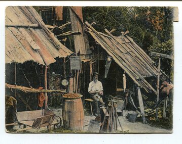
This postcard was produced as a black and white card titled, "Early 1900 - Bush Hut , Gippsland", in the early 20th century. The original card had a blank white rectangular strip on the right side of the photograph. This was for the message. There is little information with this item except for a note indicating that it was a hut at Newmerella. This is a pictorial record of a bark hut of the kind built by the early settlers of East Gippsland. Few early settlers could afford the time, or possessed the capital, to build any dwelling more impressive than a slab hut: Postcards form a vital part of social and historical records for researchers. A postcard showing a bearded man sitting on a stool outside a bark hut. There are various tools - a wheelbarrow and shovels, buckets, a panning dish and a saw hanging above him to the left. . It is in a bush setting and the photograph has been tinted.on back - POSTCARD - in red :"Essie & Ruby McKena. Emily Ville, Ascot Vale Road Flemington"dwelling-bush hut-bark -
 Federation University Historical Collection
Document - Reports, Martin Westbrooke, Nanya Station
Nanya Station, owned and managed by the University of Ballarat (now Federation University Australia), was purchased with assistance from the Department of Environment and Heritage Government Caring for our Country program. Nanya Station is located in the Scotia country, west of the Darling Ana-Branch in far western New South Wales and consists of the Nanya Western Lands Pastoral Lease 3281 – Perpetual Leasehold Lot 1244 in Deposited Plan 762778, Parish of Winnebaga, County of Tara and part of Lot 1242 County of Windeyer. Nanya is within the tribal area of the Danggali Aboriginal people, a sub-group of the Barkindji. Many Aboriginal sites have been recorded adjacent to major rivers in the region providing evidence that these areas supported a large population. The Scotia region has one of the shortest stock grazing histories of western NSW. Along with five other Scotia properties, Nanya was created as a pastoral lease in 1927. The first European settlement on the land followed exploration of the area by Sturt and Eyre. In 1854, the Lake Victoria lease which encompassed this area comprised 465,000ha.included Scotia blocks 1, 2, 3 and 4, Amoskeag and Winnebaga which formed the area known as the Scotia. It was described as a region of thick mallee scrub, interspersed with bluebush flats and Belah woodland. In the 1920s artesian water was found and the dry Scotia country was surveyed and divided into six Homestead leases allocated by ballot (Withers 1989). All properties were approximately 30,000ha, with a recommended stocking level of 3,000 sheep. Winnebaga (renamed Nanya) was taken up by Gordon Cumming. He initially dug a dam near the southeast corner of the property. A larger ground tank and rudimentary dwelling at the site of the present complex was later established. An adjacent area was cleared and cropped to provide feed for the horses used in digging the earth tanks. The ruins of the original building are located between the shearing shed and Homestead Tank. A cottage was built in the 1930s and a more substantial Red Gum framed homestead in the early 1950s. The lease was held by Mr Gordon Cumming until 1984 when it was purchased by Mr Norm Scadding as an extension to the adjacent lease, Belvedere. It was sold in 1995 to Mr Rob Taylor of Waikerie then in 1999 to BeMax Pty. Ltd., a sand mining company. These last three owners all permitted use of the property by the University for teaching and research. The Centre for Environmental Management at the University of Ballarat had been involved in studies of flora and fauna in western New South Wales since 1988. Studies became concentrated on the Scotia region with its variety of intact ecosystems due to a short pastoral history. Of particular significance is a system of natural salt lakes of which the most extensive is the Scotia Discharge Complex located on Nanya Station. An extensive vegetation survey of the Scotia region Westbrooke et al. 1998) highlighted the significance of the area both in terms of the range of communities in relatively intact condition and the occurrence of species and communities of restricted distribution. Nearly 400 species were recorded of which nine had either not previously been recorded or have restricted distribution in western NSW. Twenty-two plant communities occur on Nanya Station of which two, Halosarcia lylei low open shrubland and Hemichroa diandra/Halosarcia/Frankenia low open shrubland, are dominated by species not previously recorded from NSW. H. lylei and Acacia loderi shrublands are listed as endangered under the NSW Threatened Species Conservation Act. As noted, the area has a relatively short grazing history and, due to the presence of large areas of mallee with a Triodia understorey and restricted water supplies, stocking rates have been low. The diversity of ecosystems in relatively intact condition and extensive areas of old growth mallee made Nanya a highly significant refuge for biological diversity. This factors led to the purchase of Nanya Station by the University of Ballarat in 2004 with the assistance of the Department of Environment and Heritage for the purposes of conservation, research and education. In 2010 the southern paddocks of Nagaella Station (10,000ha.) which lie along the northern boundary, were purchased with the assistance of Lower Murray Darling Catchment Management Authority and added to the Nanya lease to provide complete protection for the communities of the Nanya Discharge Complex and further high quality Malleefowl habitat. Four digital reports documents relating to Federation University's Nanya Station, Western New South Walesnanya station, scotia country, pastoral lease, winnebaga county, darling ana-branch, martin westbrooke, environmental education, nagaella station, lower murray darling catchment management authority, conservation research education, ian gribble, pat prevett, ian henderson, danggali -
 Ringwood and District Historical Society
Mixed media - Video, RDHS Meeting Presentation - "History of East Ringwood Village" - Russ Haines
Digitised video (4.25GB). Duration: 70 minutes. Recorded July, 2019 (Video is available for viewing at Ringwood & District Historical Society Archives by appointment)In this talk, Ringwood and District Historical Society President Russ Haines takes us through East Ringwood's fascinating transition from early roots going back to working class families - some still in the area - to the village of today. East Ringwood is still seen as a quiet place, having resisted large-scale development although many larger blocks now include multiple unit dwellings. -
 City of Moorabbin Historical Society (Operating the Box Cottage Museum)
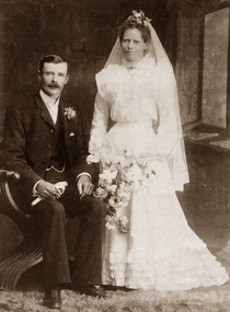
Photograph, B&W, George William Box & Elizabeth Honor Tippett Wedding 1902, c1902
Box Cottage Museum, a reconstruction of an early settler hut, is named after the Box family who resided there 1865 -1913 . George William Box 1870 -1933 was a son, and twin brother of Cecilia Eliza, of William and Elizabeth Avis Box who lived in Box Cottage and farmed the land 1865 - 1913 . George William Box married Elizabeth Honor Tippett 1902 and they had 8 children. Elizabeth Avis Box gave them a shop with a dwelling in Jasper Road where Elizabeth Honor sold groceries and vegetables while George obtained various jobs. Box Cottage Museum, a reconstruction of an early settler hut, is named after the Box family who resided there 1865 -1913 . George Box was the father of William Box who with his wife Elizabeth Avis Box and 13 children lived and farmed on the block of land in Jasper Road, East Brighton ( now McKinnon / Ormond) that was part of the Henry Dendy Special Survey 1841 Inscribed inside Album : “ The early photos in this album were found by Mr (Laurie) Lewis when he was demolishing the Old Box Cottage. He gave them to Mrs Avis Box Eldridge who in turn gave them to me. They were not identified. I believe they rightly belong in the Cottage. I have attempted to identify them and present them in a way they can be preserved as a historical record of the era.” A B Leigh A black & white Wedding photograph 1902 of George William Box 1870-1933 and Elizabeth Honor Tippet Box d1953TALMA 119 Swanston Street / Melbourne / and at Sydneybox george, box mary, box william, box elizabeth, box alonzo, box mary louisa, dendy henry, were j b, dendy's special survey 1841, brighton, moorabbin, bentleigh, mckinnon, ormond, market gardeners, dairy farms, early settlers, pioneers, jasper road, gurr jabez, gurr eliza, pay henry, pay anna, ward willam, box henry, ward elizabeth emma, box john, sheldrake martha, rushall eleanor, box caroline, box william, box elizabeth avis -
 Bendigo Historical Society Inc.
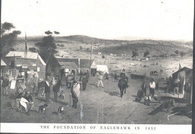
Photograph - WES HARRY COLLECTION: FOUNDATION OF EAGLEHAWK IN 1852, 1852
Photograph of an artwork depicting and early mining camp. In the foreground there is a settlement consisting of tents and some wooden buildings, There are numerous people of all ages on the street and a trooper on horseback. The road through the settlement is running down to a broad valley with some low hills in the distance. There are several tents and rough dwellings at the base of these hills. Along the bottom of the picture is written The foundation of Eaglehawk in 1852.topic, mining, eaglehawk, mining settlement, eaglehawk, diggers, early bendigo -
 Stanley Athenaeum & Public Room
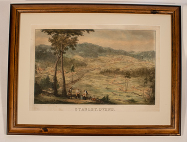
Artwork, other - Lithograph - framed reproduction - coloured, Stanley, Ovens 1859
Edward Hulme - artist's early landscape of Stanley Village overlooking the plateau and hills. There are 3 miners in the foreground washing the gravel by a cradle with 2 tall eucalypts to the left. Outlying dwellings and a water-race also feature.E.Hulme clel & lith. Ladd and Carr. imp. Reproduction company for National Library, Australia -
Lakes Entrance Regional Historical Society (operating as Lakes Entrance History Centre & Museum)
Book, Australian Aboriginal Culture, 1974
A revised edition of the brochure which accompanied the touring exhibition of Australian Aboriginal Culture promoted by UNESCO and funded by the Austalian government early 1950's. Briefly describes origins, dwellings, tribal lands, dress, hunting, toos anaboriginals -
 Stawell Historical Society Inc
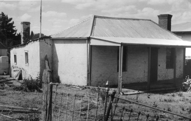
Photograph, Miners Small Brick Cottage -- early example in Curtis St
Small brick cottage a typical example of an early miners cottage located in Curtis Street. Mr. Hammer brickmaker, lived in the cottage. The cottage was also home to Mr. & Mrs. Vic Bullen for many years. Van Diesan later bought the cottage.Black & White photograph of a small brick college with corrugated iron roof. stawell dwelling -
 City of Ballarat Libraries
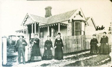
Photograph - Card Box Photographs, Hooper family at the home in Creswick circa 1870
The Hooper's were early settlers to Newlyn. The location of this building is unknown.hooper, creswick, newlyn, private dwelling, building, costume, people -
 Lakes Entrance Regional Historical Society (operating as Lakes Entrance History Centre & Museum)
Photograph, Holding M, 1996
House was demolished May 1997 to make way for RSL car park extension. Local information says house built c1900. Internal wall lining was of wall paper covered hessian attached to rough sawn timber.|Also second Photograph taken in Spring.Colour photograph of Ivy Cottage, taken early Autumn. Previously home of Bell Family in Grey Street. Timber dwelling has hipped roof with small gable at ridge, veranda across front supported by white timber veranda posts. Lakes Entrance Victoriahouses -
 Lakes Entrance Regional Historical Society (operating as Lakes Entrance History Centre & Museum)
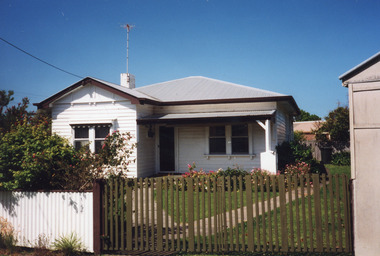
Photograph, Holding M, 2009
Built early 1900's for member of the Sutherland family, early residents of Lakes Entrance. Late occupied by Tom Beyer and family 1930's, Jean and Ray Green (baker at Freeman's store) 1950 - 1960's.Colour photograph timber dwelling with hipped roof at 4 Orme Street, the dwelling was demolished. Lakes Entrance Victoriahouses, township, heritage study -
 Lakes Entrance Regional Historical Society (operating as Lakes Entrance History Centre & Museum)
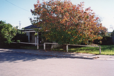
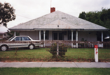
Photograph, 1999
Some residents : 1942/43 Mining Engineer by name Cook bought house. Nurse Freda Daniel had it as a private hospital named 'Ardlui'. Holiday home of Dahlsen family of Bairnsdale. Mr & Mrs Crea (Snr) 1970's - early 1980's.Colour photograph of a timber and cement sheet dwelling at 37 Myer Street. Built on square plan, hipped roof of corrugated iron extends to deep boxed eaves which cover front verandea. Unusual sash windows contain eight panes top and bottom. Lakes Entrance Victoriafences, houses, heritage study -
 Lakes Entrance Regional Historical Society (operating as Lakes Entrance History Centre & Museum)
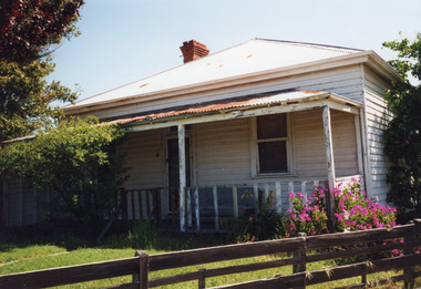
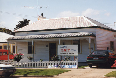
Photograph, 1999
House built early 1900's by Don Mitchelson, brother of Leo Mitchelson, local builders.Colour photograph of timber dwelling at 11 Orme Street. Has hipped roof of corrugated iron, bull nose veranda across front, trimmed with wrought iron lace. Bait for sale notices at front fence. Lakes Entrance Victoriahouses, heritage study -
 Lakes Entrance Regional Historical Society (operating as Lakes Entrance History Centre & Museum)
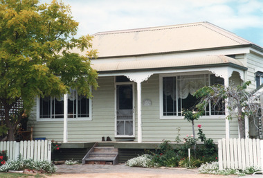
Photograph, 1999
Believed to have been built early 1900'sColour photograph of a timber dwelling at 212 Marine Parade. Hipped roof and bull nose veranda of iron. Slim timber veranda posts with decorative brackets. Metal framed windows each side of central doorway with fan light above. Lakes Entrance Victoriafences, houses, heritage study -
 Lakes Entrance Regional Historical Society (operating as Lakes Entrance History Centre & Museum)
Photograph, 2000
Some residents - Bill Giles, early 1920's, Mick and Doll Hobson, Colin and Ruby Watson, 1956's, Redenbach, Dan and Robyn Joiner, 1999.|Also one other colour photograph similar.Colour photograph of a timber dwelling a 6 Barkes Avenue. House has corrugated iron roof. Front veranda partially enclosed. Lakes Entrance Victoriahouses, fences, heritage study -
 Lakes Entrance Regional Historical Society (operating as Lakes Entrance History Centre & Museum)
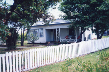
Photograph, 2000
Early occupant Mrs Rowe, when house had veranda across front, 1940's.Colour photograph of a timber dwelling with corrugated iron hipped roof, gable extension front, veranda supported by timber post set in concrete pier, situated at 8 Lakes Street, Lakes Entrance Victoriahouses, heritage study -
 Lakes Entrance Regional Historical Society (operating as Lakes Entrance History Centre & Museum)
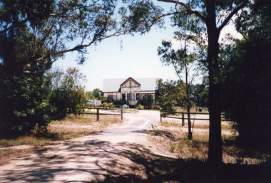
Photograph, 1999
Built late 1970's or early 1980's by Roger Simpson, cabinet maker. Internal space originally had large banquet hall in centre, surrounded by kitchen and utilities, bedrooms upstairs overlooking hall. It has since been modified.Colour photograph of a mock Tudor dwelling at Colqhuoun Road. Corrugated iron gable roof across building. Gable roofed projection centre front. Dark painted lathes on outer walls add to Tudor effects. Set well back from road with established garden. Lakes Entrance Victoriatourism, resort -
 Lakes Entrance Regional Historical Society (operating as Lakes Entrance History Centre & Museum)
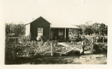
Photograph
Home of Campbell family, early residents of area. Also a photograph in book Bunga Haven on Lake Bunga number 00694 page 62 of the house called Burton's Farm House, 105 Lake Bunga Road originally known as the Wilson Farm named Cora Lynn built by Robert James Wilson. Vera Harbeck nee Wilson wrote stories for the Weekly Times c 1916 using the name of the family home as her place of residence.Sepia photograph of timber dwelling at Lake Bunga. Timber cladding appears to be oiled. Wire fence supported by round sappling post. Lakes Entrance Victoria .houses