Showing 1087 items matching "earth"
-
 Lakes Entrance Historical Society
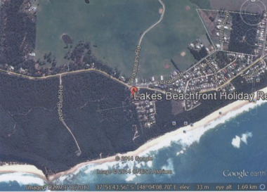
Photograph - Lake Tyers Beach, Google Earth, 2014
Colour photograph of Lakes Beachfront Holiday Resort showing Lake Tyers Beach Road, Barracouta Road and Salmon Road, walking track with ocean beach on Bass Strait in background, Bream Road in foreground, Lake Tyers Beach VictoriaLakes Beachfront Holiday Reocean, caravan parks -
 Christ Church Anglican Parish of Warrnambool
Memorial Window: John Edward BENNETT, Crucifixion "I, if I be lifted up from the earth/ will draw all men unto me"
John Edward Bennett was born in Leeds, Yorkshire, 1862. He was devoted to his family and his church, being a churchwarden and a verstryman of this Parish. He was a lay preacher for 40 years in the Dioceses of Melbourne and Ballarat. He was the first Manager of the Warrnambool Woollen Mill. He died on Nov 10th 1928.He was the first manager of Warrnambool Woollen Mill.Stained glass memorial lancet window, central light, west wall, north nave, depicting the crucifixion of Jesus.To the Glory of God and in loving memory of/John Edward Bennett/ sometime Churchwarden and Vestryman of this Parish, and for/40 years a Lay Reader in the Dioceses of Melbourne and/ Ballarat, born in Leeds, Yorkshire, 1862, entered into rest Nov 10th, 1928/ A devoted husband and father,/ a faithful servant of God and His Church/Not slothful in business, fervent in spirit, serving the Lord.memorial stained glass window lancet window bennett je bennett john edward bennett warrnambool woollen mill -
 Ballarat Clarendon College
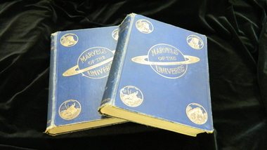
Book, Marvels of the universe: a popular work on the marvels of the heavens, the earth, plant life, animal life, the mighty deep, c1913
Both volumes were gifted to the Clarendon Presbyterian Ladies College library by the family of former student Helena Cowan who entered the school in 1882. Volumes presumably from her personal collectionLondon: Hutchinson & Co, c1913, 2 volumes, volume one 602pp, volume two pp 602 to 1162 plus Index; over 1500 illustrations and 64 colored plates. Dark Blue cloth with gilt titles and beautiful gilt cover decorations, Fair copies with wear and soiling, edgewear at all edges, endpapers a bit age-toned, previous owner's inscribed on flyleaf of both volumesInscribed on flyleaf of both volumes: H M Cowan Library stamps throughout volumes Call number on spine: 500 MARhelena-cowan, clarendon-presbyterian-ladies-college, 1913, 1882, -
 Phillip Island and District Historical Society Inc.
Book, Verne, Jules, Round the�moon�: a sequel to From the Earth to the�moon, 1881
Stamped 'Cowes Public Library'. Labelled 'Phillip Island Historical Society, Cleeland Bequest'. Inscribed Henry Blashki, from his brothers Aaron & Louis 8th Decr 1884' -
 Greensborough Historical Society
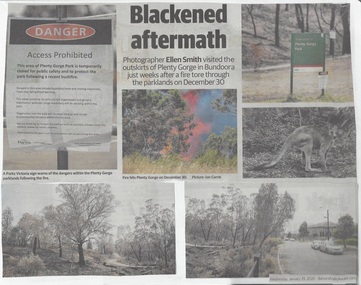
Newspaper Clipping, Diamond Valley Leader et al, Scorched Earth: attention turns to recovery plan after devastating Plenty Gorge fire, 29/01/2020
An eerie, blackened landscape remains after a bushfire ripped through more than 40 ha of the Plenty Gorge parklands.News article 2 pages, black text and colour images.plenty gorge park, bushfire -
![Newspaper Clipping - Digital Image, Act at home to help the earth [Greensborough Primary School Gr2062], 18/06/2001](/media/collectors/4f729f5697f83e03086015b8/items/5bb9789021ea6716dc37f527/item-media/5bb978bd21ea6716dc382477/item-fit-380x285.jpg) Greensborough Historical Society
Greensborough Historical SocietyNewspaper Clipping - Digital Image, Act at home to help the earth [Greensborough Primary School Gr2062], 18/06/2001
Students from Greensborough Primary School planted trees along the Plenty River, assisted by Mayor of Banyule Councillor Dale Peters.Newspaper clipping, black and white text and colour image.greensborough primary school, plenty river, dale peters -
 Eltham District Historical Society Inc
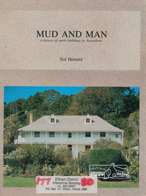
Book, Earthbuild, Mud and Man: a history of earth buildings in Australia by Ted Howard, 1992
Includes references to local sites Bear's Castle, Yan Yean (City of Whitlesea), mud brick houses in Eltham, including at Montsalvat and Eltham Community Centre, Smith's Gully, Plenty Baptist Church and Warrandyte. Includes chapter on Alistair Knox. The author's own home appears in the book on page 100. It was situated at Batman Road, Eltham next to the manse and church opposite Stanley Avenue. It was demolished for unit development June 2004 after the author's death in 2003. A significant and oft cited history of the mud brick earth construction style of architecture which includes a number of examples within the Shire of Nillumbik, known to be a site of the environmental earth building movement following WW2.198 p. : ill. (some col.), maps ISBN 0646069624earth construction, mud bricks, pise, domestic architecture -
 Federation University Historical Collection
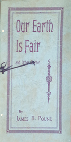
Booklet, James R. Pound, Our Earth Is Fair and Other Verses, 1931
Blue soft covered booklet of verses.non-fictionjames pound, verses, poetry -
Moorabbin Air Museum
Manual - CAC D1 Defence of CAC anti aircraft guns Bofors VDC rifles scorched earth policy camouflage air raid, CAC D1 Defence of CAC anti aircraft guns Bofors VDC rifles scorched earth policy camouflage air raid
-
 National Vietnam Veterans Museum (NVVM)
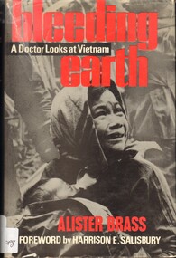
Book, Brass, Alister, Bleeding Earth: A Doctor Looks at Vietnam. (Copy 1)
There is no escape for the people of Vietnam. Around them endlessly churns the vast technology of war. They are expendable jetsam. Only the medical teams seem capable of creating small islands of sanity and security in the chaotic wilderness.There is no escape for the people of Vietnam. Around them endlessly churns the vast technology of war. They are expendable jetsam. Only the medical teams seem capable of creating small islands of sanity and security in the chaotic wilderness. vietnam war, 1961-1975 - medical care, vietnam war, 1961-1975 - medical care - personal narratives - australian -
National Vietnam Veterans Museum (NVVM)
Book, Bleeding Earth: A Doctor Looks at Vietnam. (Copy 2)
There is no escape for the people of Vietnam. Around them endlessly churns the vast technology of war. They are expendable jetsam. Only the medical teams seem capable of creating small islands of sanity and security in the chaotic wilderness.There is no escape for the people of Vietnam. Around them endlessly churns the vast technology of war. They are expendable jetsam. Only the medical teams seem capable of creating small islands of sanity and security in the chaotic wilderness. vietnam war, 1961-1975 - medical care, vietnam war, 1961-1975 - medical care - personal narratives - australian -
 National Vietnam Veterans Museum (NVVM)
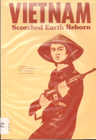
Book, Cairns, Jim Dr, Vietnam: Scorched Earth Reborn- A Graphic Account of Vietnams Fight For Survival (Copy 2)
For many it seemed that Vietnam had forever been a battlefield and yet, in April 1975, a strange peace fell over the country.For many it seemed that Vietnam had forever been a battlefield and yet, in April 1975, a strange peace fell over the country.vietnamese conflict, 1961-1975 -
 National Vietnam Veterans Museum (NVVM)
Book, Cairns, Jim, Vietnam: Scorched Earth Reborn. (Copy 1)
For many it seemed that Vietnam had forever been a battlefield and yet, in April 1975, a strange peace fell over the country.For many it seemed that Vietnam had forever been a battlefield and yet, in April 1975, a strange peace fell over the country. vietnamese conflict, 1961-1975 -
 Horsham Regional Art Gallery
Photograph, Melissa POWELL, Earth weave, 2007
Purchased through the Horsham Art Gallery Trust Fund, 2011 -
 Robin Boyd Foundation
Book, David Attenborough, Life on Earth, 1979
Hardcover w/ Dust Jacketwalsh st library -
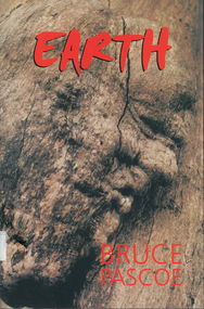 Victorian Aboriginal Corporation for Languages
Book, Bruce Pascoe, Earth, 2001
Novel partially in Wathaurong.wathaurong -
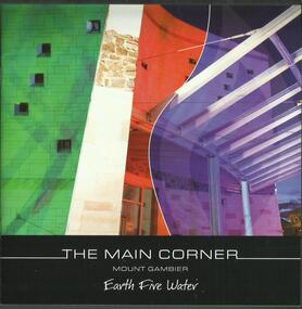 The Adam Lindsay Gordon Commemorative Committee Inc.
Booklet, The Main Corner, Mount Gambier : earth, fire, water, 2011
Information booklet about the new Main Corner complex located at 1 Bay Road, Mount Gambier. The building and surrounds offer the opportunity to learn about Mount Gambier's local history and culture.For two years he was stationed at Penola in the Mount Gambier region where he led a routine life with no remarkable incidents or exploits to interrupt his daily duties. (from Australian Dictionary of Biography: http://adb.anu.edu.au/biography/gordon-adam-lindsay-3635)22 pages booklet with colour illustrations. Front page depicting the entrance of the Main Corner in Mount Gambiermain corner, mount gambier, gretel sneath, adam lindsay gordon -
Swan Hill Regional Art Gallery
Print, TROVA, Ernest, Head, planet earth (falling man series), unknown
-
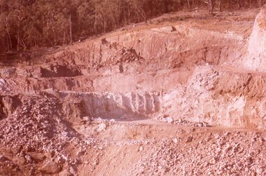 Stawell Historical Society Inc
Slide, Ian McCann, Earth Works at the Construction of Lake Bellfield, 1960's
Constuction of Lake BellfieldColour Slide. Showing the Earthworks at Lake Bellfield during Constructiongrampians -
Swan Hill Regional Art Gallery
Print, MORTENSEN, Kevin Christian, Mor Jard (Mother Earth), 1999
-
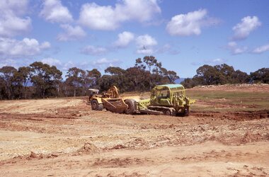 Stawell Historical Society Inc
photograph - Slides, Ian McCann, Earth Moving, 1976 -1984
Colour Photograph of heavy equipment moving soil -
 Ballarat Heritage Services
Photograph - Colour, Earth Banks, Old Sarum, England, 2016, 01 November 2016
William the Conqueror inherited Old Sarum from the last Saxon king of England. It was an ideal site for a royal castle. It was here in 1070 that William paid off his army after a long and bitter campaign in northern England. It was here in 1086 that he called together all the major landholders in England so they could swear allegiance to him. It was a crucial moment. The Domesday Book was being written, a threatened Viking invasion had only just been averted and William's eldest son was in armed rebellion. Old Sarum was an important place where this Norman king of England held power. In 1794 the Ordnance Survey set out to check the accuracy of the first mapping of Southern England, which had begun ten years earlier. From a point just below Old Sarum Lieutenant William Mudge laid out a base-line 36,574 feet (11,253 metres) long. From each end of the line the positions of distant places were plotted using a huge theodolite made in 1791 by Jesse Ramsden. The accuracy of the process, which was repeated all over England, depended on Jesse Ramsden's craftsmanship and on William Mudge's surveying skill in setting out this first base-line from Old Sarum. The nearer end of Mudge's line is marked by an inscribed stone beside the modern A345 at Old Sarum. ordnance survey, william mudge, jesse ramsden, william the conqueror, old sarum, saxon, 1086, england -
 Ballarat Heritage Services
Photograph - Colour, Earth Banks, Old Sarum, England, 01 November 2016
William the Conqueror inherited Old Sarum from the last Saxon king of England. It was an ideal site for a royal castle. It was here in 1070 that William paid off his army after a long and bitter campaign in northern England. It was here in 1086 that he called together all the major landholders in England so they could swear allegiance to him. It was a crucial moment. The Domesday Book was being written, a threatened Viking invasion had only just been averted and William's eldest son was in armed rebellion. Old Sarum was an important place where this Norman king of England held power. In 1794 the Ordnance Survey set out to check the accuracy of the first mapping of Southern England, which had begun ten years earlier. From a point just below Old Sarum Lieutenant William Mudge laid out a base-line 36,574 feet (11,253 metres) long. From each end of the line the positions of distant places were plotted using a huge theodolite made in 1791 by Jesse Ramsden. The accuracy of the process, which was repeated all over England, depended on Jesse Ramsden's craftsmanship and on William Mudge's surveying skill in setting out this first base-line from Old Sarum. The nearer end of Mudge's line is marked by an inscribed stone beside the modern A345 at Old Sarum. ordnance survey, william mudge, jesse ramsden, william the conqueror, old sarum, saxon, 1086, england -
 Ballarat Heritage Services
Photograph - Colour, Dorothy Wickham, Earth Banks, Old Sarum, England, 2016, 01 November 2016
William the Conqueror inherited Old Sarum from the last Saxon king of England. It was an ideal site for a royal castle. It was here in 1070 that William paid off his army after a long and bitter campaign in northern England. It was here in 1086 that he called together all the major landholders in England so they could swear allegiance to him. It was a crucial moment. The Domesday Book was being written, a threatened Viking invasion had only just been averted and William's eldest son was in armed rebellion. Old Sarum was an important place where this Norman king of England held power. In 1794 the Ordnance Survey set out to check the accuracy of the first mapping of Southern England, which had begun ten years earlier. From a point just below Old Sarum Lieutenant William Mudge laid out a base-line 36,574 feet (11,253 metres) long. From each end of the line the positions of distant places were plotted using a huge theodolite made in 1791 by Jesse Ramsden. The accuracy of the process, which was repeated all over England, depended on Jesse Ramsden's craftsmanship and on William Mudge's surveying skill in setting out this first base-line from Old Sarum. The nearer end of Mudge's line is marked by an inscribed stone beside the modern A345 at Old Sarum. King William devised the Domesday Book, considered to be the first listing of land owners in England. Among the names is that of D'Arques, from Normandy, France. Descendants of this family later emigrated from England and settled in Victoria, Australia under the surname 'Dark'. ordnance survey, william mudge, jesse ramsden, william the conqueror, old sarum, saxon, 1086, england -
 Ballarat Heritage Services
Photograph - Colour, Earth Banks, Old Sarum, England, 2016, 01 November 2016
William the Conqueror inherited Old Sarum from the last Saxon king of England. It was an ideal site for a royal castle. It was here in 1070 that William paid off his army after a long and bitter campaign in northern England. It was here in 1086 that he called together all the major landholders in England so they could swear allegiance to him. It was a crucial moment. The Domesday Book was being written, a threatened Viking invasion had only just been averted and William's eldest son was in armed rebellion. Old Sarum was an important place where this Norman king of England held power. In 1794 the Ordnance Survey set out to check the accuracy of the first mapping of Southern England, which had begun ten years earlier. From a point just below Old Sarum Lieutenant William Mudge laid out a base-line 36,574 feet (11,253 metres) long. From each end of the line the positions of distant places were plotted using a huge theodolite made in 1791 by Jesse Ramsden. The accuracy of the process, which was repeated all over England, depended on Jesse Ramsden's craftsmanship and on William Mudge's surveying skill in setting out this first base-line from Old Sarum. The nearer end of Mudge's line is marked by an inscribed stone beside the modern A345 at Old Sarum. ordnance survey, william mudge, jesse ramsden, william the conqueror, old sarum, saxon, 1086, england