Showing 190 items
matching extracting gold
-
 Bendigo Historical Society Inc.
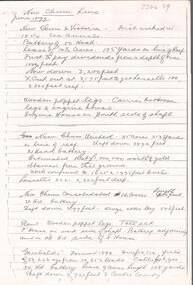
Document - ALBERT RICHARDSON COLLECTION: NEW CHUM LINE OF REEF MINES
... , dividends, ounces of gold extracted and depth of shafts... workings on the reef line. Calls, dividends, ounces of gold ...Five page document, handwritten, detailing the mines along the New Chum Line of Reef. A table of information is attached with data about the early workings on the reef line. Calls, dividends, ounces of gold extracted and depth of shafts are described.bendigo, mining, new chum line of reef -
 Bendigo Historical Society Inc.
Document - LIDDEL'S PYRITES WORKS & LEGGO'S BURNER
... give description of how Liddel's Pyrite extracted the gold... extracted the gold and collected arsenic which was sold ...Handwritten notes about Liddel's Pyrite Works which first worked about 100 years as the Derwent Gully Pyrites Works. Notes give description of how Liddel's Pyrite extracted the gold and collected arsenic which was sold to manufacturers as sheep-dip, weed poison, etc. Also mentioned is Leggo's Burner which started operations, 1906 and closed about 1949 or 1950.document, gold, liddel's pyrites works, liddel's pyrites works & leggo's burner, pyrites -
 Bendigo Historical Society Inc.
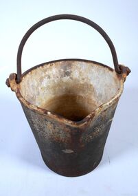
Functional object - Amalgam bucket
... extract the gold. The amalgam of mercury and gold was placed... extract the gold. The amalgam of mercury and gold was placed ...Ore bearing rock brought out of the mine was crushed at the battery by heavy metal stampers and the fine material passed over copper pates coated with mercury. Gold particles would combine with the mercury forming an amalgam which was then scrapped off the copper plates and put into the amalgam bucket ready for retorting too extract the gold. The amalgam of mercury and gold was placed into the retort which was heated to evaporate the mercury. The mercury cooled as it ran down the pipe which was recovered to be reused leaving the gold behind. The gold would later be put into a crucible and heated to burn of impurities and the molten pure gold poured into an ingot.A heavy cast iron bucket 20 centimetres high, 16 centimetres in diameter at its base and 22 centimetres diameter at the top. It has a spout five centimetres wide protruding two centimetres. There is a handle which is a semi- circular shape 19 centimetre wide extending 14 centimetres above the bucket The inside of the bucket has an enamel coating. amalgam bucket, bendigo gold, gold retort -
 Bendigo Historical Society Inc.
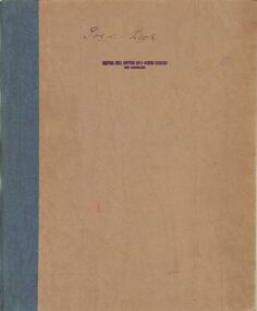
Document - MCCOLL, RANKIN AND STANISTREET COLLECTION: CENTRAL NELL GWYNNE BULLION BOOK
... crushed and the amount of gold extracted. Dates range from 20th... and the amount of gold extracted. Dates range from 20th March 1942 ...Brown leatherette book with blue binding. Stamped on the front cover: Central Nell Gwynne Gold Mining company No Liability. And written in ink: Gold Book. Detailing tonnages of ore crushed and the amount of gold extracted. Dates range from 20th March 1942 to 19th January 1950.gold, mining, central nell gwynne, bendigo, gold mines, central nell gwynne -
 The Beechworth Burke Museum
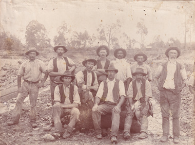
Photograph, c. 1870
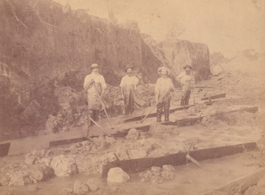
... is a method used to extract gold and other precious metals from... is a method used to extract gold and other precious metals from ...This photograph was captured at an undisclosed location and at an unidentified time but likely dates to approximately 1870. The photographer's details are not recorded and the identities of the men in the image are also not known. This image depicts a group of 10 men in typical miners fashion. Four of them are sat on a large log with one holding a small dog. Six miners stand behind those sitting. All these men are wearing a white button-up shirt and tan coloured work trousers. They wear heavy boots and seven have included a dark vest over their shirt. The man holding the dog has a pipe in his mouth. Two of these men are clean shaven with the remainder sporting a moustache and two with a beard. The ages of these men vary from late 20s to middle age. This group of men are located in a mining location with what appears to be an open cut mine in the background of the image. The ground is muddy and has elements which can help identify it as a mining location based on the condition of the landscape. The bottom of the men's trousers are muddy which provides the assurance that these men were working in this location when their photograph was captured. In the background there is one structure, possibly a dwelling, and bush which identifies the location as Australia. Open cut sluicing is a method used to extract gold and other precious metals from beneath the surface of the earth. This technique involved the use of high-powered hoses which broke down the soil enabling miners to come along and search this soil for gold. After the gold rush of the early 1850s, diggers had to enlist the assistance of heavy machinery and techniques like hydraulic sluicing in order to reach gold because the surface alluvial gold had already been discovered and removed. This heavy machinery was not used until after 1853. The search for gold is ingrained into the history of Victoria and therefore, images like this one which portray an open cut sluicing site can reveal important information for society and technology for the date when the photograph was taken. This image is of important historical significance for its ability to convey information about sluicing and the methods used to find gold in the late 1800s and early 1900s. It also shows a location where sluicing was undertook which provides insight into the impact of sluicing on the environment at a time when it was done. Images, like this one, of Australian gold rush history can reveal important information about the social and environmental impact of this period. This image depicts diggers standing in a mining location and therefore, this image has the capacity to reveal or support significant information for researchers studying the fashion and social status of diggers in Australia in approximately 1870. It can also provide information on the landscape of Australia in this period and the impact of mining for gold on both society and the Australian landscape. The Burke Museum is home to a substantial collection of Australian mining photographs which can be used to gain a deeper understanding into life on the gold fields, technology used in mining, the miners themselves and the impact of the gold digging on the environment.Sepia toned rectangular photograph printed on matte photographic paper mounted on board.Reverse: 1997.2518mining, goldfields, beechworth, 1870, australia, australian goldfields, diggers, victoria, sluicing, gold mining, miners, diggers victoria -
 Bendigo Historical Society Inc.
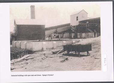
Photograph - Spargo's Pyrites, Specimen Hill
... ore, the sand pyrites remaining could be treated to extract... ore, the sand pyrites remaining could be treated to extract ...Historic photo of mining at Specimen Hill. After crushing ore, the sand pyrites remaining could be treated to extract even finer gold. The sand was placed in large brick ovens to be roasted, which freed the sand of arsenic, sulphur etc, with the fumes containing these elements released into the atmosphere via a large chimney. Spargo's Pyrite Company operated from about 1870. It closed when there became a shortage of workers during WW1 and appears to have not restarted after the war. Black and white image, possibly copy. Weatherboard building on left hand side, elevated weatherboard building centre with chute descending to lower building. Possibly Spargo's Pyrites works, date unknownspargo's, pyrites -
 Bendigo Historical Society Inc.
Slide - DIGGERS & MINING. DIGGERS AND MINERS, 1800s
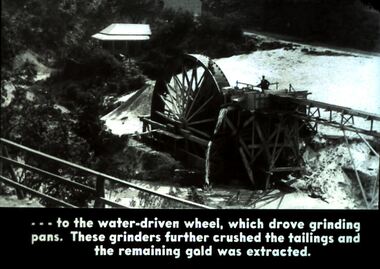
... crushed the tailings and the remaining gold was extracted... and the remaining gold was extracted. Markings: 43 994.5 WAL. Used ...Diggers & Mining. Diggers and Miners. . . . . To the water-driven wheel, which drove grinding pans. These grinders further crushed the tailings and the remaining gold was extracted. Markings: 43 994.5 WAL. Used as a teaching aid. Used as a teaching aid.hanimounteducation, tertiary, goldfields -
 Wodonga & District Historical Society Inc
Photograph - North-Eastern Gold Days, 1900
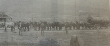
... , the gold was difficult to extract, and the discovery of copper led... and was known as the 'Talgarno diggings'. Reports of alluvial gold date ...Bethanga was established as a result of the discovery of gold. Gold was first reported in the Bethanga area in 1852. Before 1876 gold mining in the Bethanga district occurred to the north of the town and was known as the 'Talgarno diggings'. Reports of alluvial gold date back to 1852. Early gold fields were worked at Ruby Creek, Gold Creek and Jarvis Creek. The opening of the Bethanga goldfields began with the discovery of a gold-bearing quartz reef on New Year’s Day 1876. The 'Gift' mine site is located southeast of Kurrajong Gap lookout to the west of Bethanga township. The Great Eastern Copper Smelting Works was opened in 1878. Due to the nature of the gold-bearing quartz reef, the gold was difficult to extract, and the discovery of copper led to a change in focus. It was not until the early 1890s that an efficient technique for extracting the gold from the ore was discovered, and once again gold became the focus, with copper as a by-product. Bethanga was removed from the official list of goldfields in 1912, however some mining activity has taken place since.This image reflects an important time in the development of Bethanga and Northeast Victoria.A large mounted and framed image of horse teams and their owners hauling a large boiler to the gold mine near Bethanga, Victoria. On label beneath image: "North-eastern "Gold Days"/ Combined teams hauling a boiler to Bethanga Mines, 1900. Teamsters - Mr. G. Pearce, W. Chapple, G, Bannon." Donated by Ron Saunders and Barbara Cadman"bethanga, gold mining northeast victoria, gold mining bethanga, bethanga history -
 Bendigo Historical Society Inc.
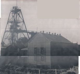
Photograph - CENTRAL DEBORAH GOLD MINE
... deep. Gold extracted 29,460 ounces. This mine was purchased..., Bendigo. 1939-1954. Shaft 1347 feet deep. Gold extracted 29,460 ...Black and white photo. Central Deborah Gold Mine, corner Violet and Creek Streets, Bendigo. 1939-1954. Shaft 1347 feet deep. Gold extracted 29,460 ounces. This mine was purchased by the Bendigo City Council to be retained as a Mining Museum. Markings/Inscriptions: Central Deborah Mine. Corner Violet and Creek Streets. 1939-1954. Shaft 1347 feet. Gold 29,460 ozs. This Mine has been purchased by the Bendigo City Council to be retained as a Mining Museum.organization, business, central deborah gold mine -
 The Beechworth Burke Museum
Photograph, c.1870
... to extract gold and other precious metals from beneath the surface... is a method used to extract gold and other precious metals from ...This photograph was taken in approximately 1870 and depicts four male miners standing in mining sluice at the Three Mile Goldfields. These men are wearing typical attire for 1870s gold miners. They wear white shirts, tan coloured pants with water proof shoes and most of the men are wearing an apron to prevent their clothing from becoming too dirty from the mud. Each man is wearing a wide brim hat and hold large wooden tools used for sorting through the sluice. Three of the four men have full beards. The photograph was donated to the Burke Museum by R. Ziegenbein before 2001 but the photographer and the individuals captured in the photo are unknown. The image depicts the landscape of the Three Mile Goldfields during a period when open cut sluicing was undertaken to reach gold. Open cut sluicing is a method used to extract gold and other precious metals from beneath the surface of the earth. This technique involved the use of high-powered hoses which broke down the soil enabling miners to come along and search this soil for gold. After the gold rush of the early 1850s, diggers had to enlist the assistance of heavy machinery and techniques like hydraulic sluicing in order to reach gold because the surface alluvial gold had already been discovered and removed. This heavy machinery was not used until after 1853. The Three Mile Goldfields was a site of rich alluvial gold deposits located about 5 km south of Beechworth in Victoria. Today, the location of this gold deposit is called Baarmutha. It was a popular area for gold mining in the 1850s but became largely abandoned by the following decade. In 1865, a man named John Pund recognized that the area could be potentially rich if a better water supply could be obtained. He secured a 15 year license with three other miners. Within the next five years, these men had constructed 19 km of water race going from Upper Nine Mile Creek to Three Mile Creek. By 1881, these four men had delivered 950,000 gallons to the Three Mile Sluicing area which is depicted in this photograph. Pund was later go into partnership with John Alston Wallace who would become owner of the Star Hotel in Beechworth. The Three Mile sluicing location continued to be operational until 1950. Sluice box workers were a vital part of gold mining regardless of how inefficient they were in the recovery of gold. After using hydraulic sluicing to cut away the earth, miners would use the big wooden boxes depicted in the image to catch the earth which would then be sifted for gold. However, accidents would occur often which would result in the gold washing away and unable to be recovered. It was not a very efficient system because the gold, which was alluvial and thus very fine, would often pass through the sluice box undetected.The search for gold is ingrained into the history of Victoria and therefore, images like this one which portray an open cut sluicing site can reveal important information for society and technology for the date when the photograph was taken. This image is of important historical significance for its ability to convey information about sluicing and the methods used to find gold in the late 1800s and early 1900s. It also shows a location where sluicing was undertook which provides insight into the impact of sluicing on the environment at a time when it was done. Images, like this one, of Australian gold rush history can reveal important information about the social and environmental impact of this period. This image depicts diggers standing in a mining location and therefore, this image has the capacity to reveal or support significant information for researchers studying the fashion and social status of diggers in Australia in approximately 1870. It can also provide information on the landscape of Australia in this period and the impact of mining for gold on both society and the Australian landscape. The Burke Museum is home to a substantial collection of Australian mining photographs which can be used to gain a deeper understanding into life on the gold fields, technology used in mining, the miners themselves and the impact of the gold digging on the environment.Sepia toned rectangular photograph printed on matte photographic paper and mounted on board.[illegible] about 1870 / 97 2514.1 / 2594 30three mile goldfields, goldfields, 1870, 1870 gold, australia, australian landscape, miners, gold miners, diggers, gold diggers, beechworth, victoria, sluice box workers, sluicing, sluice, mining -
 Bendigo Historical Society Inc.
Document - ALBERT RICHARDSON COLLECTION: THE VICTORIA HILL, HISTORICAL CONNECTIONS
... historical connections. Extract from document: Gold first found... Victoria Hill, it's historical connections. Extract from document ...One page handwritten document titled Victoria Hill, it's historical connections. Extract from document: Gold first found in 1853 by two colored men, one named Weymouth or 'Dido'. Sold out to Theodore Ballerstedt senior, who in Deember 1853 was known as the 'Father of the Hill'. In the first six years, this Hill produced more than $1,200,000 worth of gold and this in a period when crushing with crude appliances cost $13 a ton instead of $0.50c to 80 cents per ton, and unskilled men were receiving $2.00 per day instead of 75 cents a day for practical miners some years later.bendigo, mining, victoria hill -
 Bendigo Historical Society Inc.
Document - VICTORIA HILL - MINES SITUATED ON VICTORIA HILL
... such as depth, ounces of gold extracted and who owned them. Mines... some information about them such as depth, ounces of gold ...Three pages of typed notes on creamy paper. Notes mention the mines on Victoria Hill and gives some information about them such as depth, ounces of gold extracted and who owned them. Mines mentioned are: The North Old Chum, Lansell's Big 180, Ballerstedt's Open-Cut, Little 180 Crushing Battery, the Victoria Quartz, Rae's Open-Cut, Great Central Victoria, Wittshiebe's 'Jeweller's Shop', Boldt's 5 Head Crushing Battery, Northern Slope and the Advance Shaft. Written in pencil at the top: Copy of material sent to Herald Reporter by R. Aulsbrook 30/7/68. Copied from my material and initialled AR. Notes prepared by Albert Richardson.mine, gold, victoria hill, victoria hill, mines situated on victoria hill, john wybrandt, wittscheibe, t ballerstedt, fortuna villa, george lansell, a h q survey regiment, ballerstedt's open-cut, little 180 crushing battery, little 180 mine, new chum syncline, victoria quartz (victoria reef quartz), rae's open-cut, william rae, great central victoria (midway), adventurer, wittshiebe's 'jeweller's shop', boldt's 5 head crushing battery, northern slope, the advance shaft, cinderella, hercules and energetic, john brown knitwear factory, r aulsbrook, the herald -
 Bendigo Historical Society Inc.
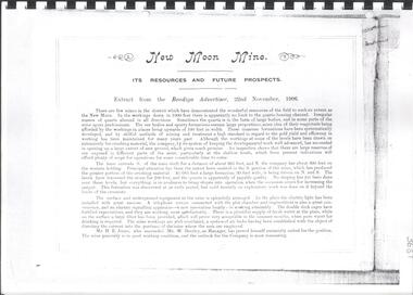
Document - NEW MOON MINE RESOURCES AND FUTURE PROSPECTS REPORT
... financial reports, gold extracted, shareholders, battery manager's... prospects'. Document contains financial reports, gold extracted ...Copy of extract from the Bendigo Advertiser, 22nd November, 1906 spiral bound with plastic cover. On front: 'New Moon Mine Site, its resources and future prospects'. Document contains financial reports, gold extracted, shareholders, battery manager's report, map of leases held by New Moon Co and photos, see below. Photo of Managers of New Moon Co., H.E. Jones Mining Manager, J.C. McCoy Engineer, R.A. Dewar Battery Manager. Photo of directors: Joseph LanFranchi, W.B. Walker, Daniel Murdoch, John Green, Alexander Hay and Edward Bright. Photos include view from base of poppet legs showing tramway and crushing machine, battery and mine, miners at the 1045 level.bendigo, mining, new moon co. nl -
Clunes Museum
document
... & STAMPS (Extract taken from publication, The Gold Fields, Mineral... Press 1979) .4 GOLD. ITS OCCURRENCE AND EXTRACTION (Extract ...INFORMATION ABOUT A STAMP SHOE FROM A CORNISH STYLE SQUARE-HEAD STAMP BATTERY POSSIBLY USED BY PORT PHILLIP MINE, CLUNES, FROM MATTHEW CHURCHWARD, SENIOR CURATOR, ENGINEERING & TRANSPORT, MUSEUM OF VICTORIA LETTER DATED 15 OCTOBER, 1997. THE GOLDFIELDS AND MINERAL DISTRICTS OF VICTORIA. GOLD ITS OCCURRENCE AND EXTRACTION, PLAN OF GOLD MINING COMPANIESINFORMATION RECEIVED REGARDING THE PORT PHILLIP MINE; Including .1 COPY OF ARTICLE 12TH MAY, 1858 FROM "THE ARGUS." MELBOURNE. .2 LETTER FROM "SCIENCEWORKS" TO MR. ALAN KEEBLE DATED 15/10/1997 (3 Pages) .3 SECTION OF MERCURY, TROUGHS, STAKES & STAMPS (Extract taken from publication, The Gold Fields, Mineral Districts of Victoria, by R. Brough Smyth F.G.S, published by Queensberry Hill Press 1979) .4 GOLD. ITS OCCURRENCE AND EXTRACTION (Extract taken from publication, Gold: Its Occurrence and Extraction by Alfred G. Lock F.R.G.S published by E. & F. N. Spon 16 Charing Cross London 1882) .5 PLAN OF GOLD MINING CO'S. CLUNES (Extract taken from Dicker's Mining Record 26/3/1867, page 173. https://trove.nla.gov.au/work/32734386?q&versionId=39944948) local history, mining, company exploration -
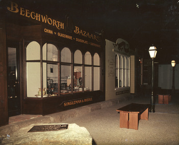 The Beechworth Burke Museum
Photograph, 1990s -- estimated
Taken in the 1990s, this photograph depicts a line of historically restored shopfronts on Ford Street, Beechworth, with Beechworth Bazaar in the foreground and George Gammon's Chemist and Druggist adjacent to it.This photograph is of social significance to the Beechworth community in depicting the Street of Shops, the creation of curator, Roy Harvey, which opened in 1979 at Burke Museum. According to the Indigo Shire Council webpage for Burke Museum, this addition 'began a new period of collecting with Roy Harvey calling to the community for donations. The response resulted in an influx of material adding to the town history/ development and local identities collections. The Shops and their contents reflect another period in museology.' This photograph evokes the historic shopfronts of Beechworth Bazaar and George Gammon's Chemist and Druggist from the Street of Shops, which were established during the mid-1850s on the back of gold mining wealth. The expansion of banks within Beechworth also stimulated the local economy.Colour rectangular photograph printed on gloss photographic paper.Obverse: BEECHWORTH BAZAAR est. 1855/ CHINA GLASSWARE SILVERPLATE EARTHENWARE/ ?ESTER HO?E/ R.?ALL. ? LT.LITTLEWOO?/ SINGLEMAN & RIEDLE GEORGE GAMMON/ MEDICAL GALVANISM/ CUPPING/ TEETH EXTRACTED/ CHEMIST & DRUGGIST Reverse: 3. 3055 burke museum, beechworth, beechworth bazaar, 19th-century victorian history, beechworth historic shops, burke museum, promoting settlement, marketing and retailing, living in country towns, making regional centres, preserving traditions and commemorating, victorian gold rush towns, beechworth pioneers, 1850s beechworth -
 Orbost & District Historical Society
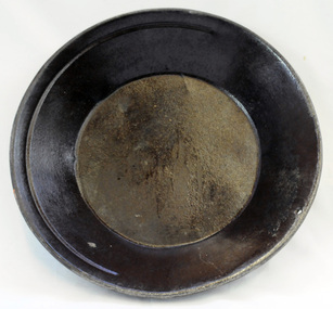
gold panning dish, mid - late 19th century
... . Gold panning is the oldest and simplest method of extracting ...Panning dishes were used for washing fine gold from river sediments or from the residue trapped in cradles and puddling tubs. They were often used on the edge of streams/rivers to sift gold from alluvial soil or crushed quartz. This simple pan would have been filled with sand and gravel which might have contained gold. The pan was submerged in the water and shaken to sort the gold from the gravel and other material, with the lighter material gradually being washed over the lip until only the heavy deposits, such as gold, remained at the bottom. (ref. Museum Victoria) This pan was used by George Henry Douglas Russell Snr. As a young man prior to his enlistment in WW1 he panned for gold using this dish. During the war he became a vet sergeant in charge of horse lines.Gold panning is the oldest and simplest method of extracting gold. Gold pans had widespread use in alluvial gold fields where water is available. This item is an example of the type of pan commonly used on Victorian gold fields.A circular dull metal panning dish which has a wide rolled top lip which tapers down to a smaller diameter for the base which is flat. The pan has been made from ironmetal which has a coating of another metal with a matte grey finish. It has a small hanging hole and a reinforcing ring all around the top.russell-doug gold-panning mining -
 Orbost & District Historical Society
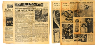
newspapers, Guinea Gold, 1943-1944
In WWII New Guinea, GUINEA GOLD presented news to all troops "in the field". It avoided editorial comment. It published for 1320 continuous days, without missing a single edition. The front and back pages concentrated on current world news, including major sporting events. Page 2 was generally devoted to extracts from Australian and US newspapers. Some news was obtained by taking shorthand notes of short-wave radio bulletins from Australia, the U.S. and the B.B.C. At its peak, distribution was 37,000 to US forces and 27,000 to Australian forces, daily. The daily version had four pages and the WEEK-END SUPPLEMENT edition contained 8 pages (with extra pictures & cartoons).Guinea Gold" daily brought to the news-hungry men of the Australian and American forces serving in the steaming jungle, topics of interest to allay their boredom and boost their morale. It was able to do so because US General Douglas MacArthur, Supreme Commander of Allied Forces in the South-West Pacific, gave it permission to publish his communiqués 20 hours before the release time for the rest of the world's media. The newspaper contains Australian, American & world news (military, political, sports & tabloid).Seven editions of "Guinea Gold" from 1943 and 1944. 2103.1 is edition 7/6/1943. 2103.2 is edition 8/6/1943. 2103.3 is edition 12/6/1943. 2103.4 is edition 27/2/1944. 2103.5 is edition 26/3/1944 and is the Weekend Supplement. 2103.6 is edition 26/3/1944 and 2103.7 is dated 9/4/1944 and is the Weekend Supplement.guinea-gold newspaper ww11 pacific-campaign new-guinea -
 The Beechworth Burke Museum
Photograph - Photograph - Reproduction
... information about the methods used to extract gold in 1900 ...This photograph depicts the Great Southern Mine located in Rutherglen as it was during the 1900. After the initial Gold Rush of 1853-1854, Gold was discovered deeper under the surface of the earth in the 1860 after the discovery of another deep lead system. Due to the discovery of Gold in Rutherglen, Rutherglen developed into a community in its own right, possessing a population of 6600 by December 1860 and developed into a municipality in 1862. The Great Southern Mine depicted in this photograph required the use of a range of modern technologies, including the hydraulic pumps, in order to reach gold. This photo depicts the mining operations as they were undertaken around the turn of the century.The search for gold is ingrained into the history of Victoria and therefore, images like this one which portray a modern mining operation undertaken in the 1860s, can reveal important information for society and technology for the date when the photograph was taken. This image is of important historical significance for its ability to convey information about the methods used to extract gold in 1900. It is significant as most mining operations around the region, particularly earlier on in the period, used different technologies such as water races. This image is important for current research into the history of Rutherglen more generally, a town which developed singlehandedly due to the discovery of minerals and mining, as depicted here in this photograph, thus indicating an element of social significance as well as historic. The Beechworth Burke Museum has additional images relating to mining and Rutherglen which can be analysed and studied alongside images like this one.A black and white rectangular photograph printed on matte photographic paper.Reverse: $ 3.00 19972503 / a02503 / Great Southern Mine Rutherglen 1900rutherglen mine, rutherglen, great southern mine, beechworth, mine, mining, post goldrush, victoria, gold, 1860s, sluicing, hydrolic sluicing -
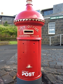 Flagstaff Hill Maritime Museum and Village
Functional object - Post Office Receiving Pillar, 1885
Post Office Receiving Pillar was Collected from Warrnambool City Council’s Scott Street Depot and transported to Flagstaff Hill, stored in the Barracks area Friends of Flagstaff Hill began the project of restoring the Post Office Receiving Pillar in early 2011. The replacement dome required a pattern to be made from paper, then timber, then someone to manufacture it. The cast iron body required sand blasting and undercoating. The pillar was installed in Flagstaff Hill Maritime Village in March 2014. A specialist visited the Village and painted the pillar with 7 coats of ‘post office red’ then completed the job with gold paint on the details. In 2015 an information plate of brass was fitted to the Pillar in the position that would have originally announced the clearing times. It was originally manufactured by G Couch, Engineer, Alliance Iron Works, Melbourne. Gordon Couch passed away in June 1896 and his Works were offered for auction in November 1897. HISTORY OF POST OFFICE RECEIVING PILLARS In 1851 ‘pillar boxes’ were installed at roadside locations in the island of Jersey, England; they had already been successful in several European countries. The use of new prepaid, adhesive postage stamps as well as the roadside pillar boxes meant there was no need for the public to take a trip to the Post Office just to post a letter. By 1855 London had installed its first six Pillar Boxes. In 1856 the pillar boxes were first introduced in Sydney. These were circular with a crown on the dome, supported by leaves. Early Victoria Mail was originally collected by ‘letter carriers’, first appointed in Melbourne in 1841, equipped with leather bag and hand bell. He wore a red coat with brass buttons and a black top hat! In 1844 two wooden receiving boxes were erected in Melbourne. The first cast iron boxes were installed in South Melbourne (Emerald Hill) and were still in service until 1967. They were a fluted circular design and made in England. In the early 1860’s the ‘low door round’ design posting box was introduced, being circular and surrounded by a crown, with two broad embossed bands around its circumference. The clearance door was in front of the box and low down. These were made in Australia. In the early 1870’s square boxes with a tapering top were being used. These too were made in Australia by different manufacturers with slight variations on style such as the orientation and number of slots. Next came the circular boxes again, similar to the ‘low door round’ but with the clearance door extending to just below the posting slot, often referred to as ‘high door round’. These boxes did not have embossed bands. In 1887 small cast iron boxes were introduced, attached to posts and poles and called ‘lamp post receivers’. Around 1930 a ‘London’ model was used in Victoria. It was copied from the flat-domed type in London but made in Tasmania. … [References: Flagstaff Hill Maritime Village records, The Argus, 11th April, 1890, The Argus, 2nd July, 1896, The Argus, 30th Nov. 1897, “Stamps.Au” http://www.stampsau.com, 4th April 2011 (Extracted from “Australian Street Posting Boxes” by Ken Sparks – out of print)] Post Office Receiving Pillar, or letterbox.1885 "High Door Round" design, restored 2014 Tall cast iron sylinder with decorative dome cap, slot in side, hinged door with handle shaped as a fist. Painted red with gold trip..Reconditioned barrel, reconstructed dome. Restored by Friends of Flagstaff Hill, 2014. Now a working letterbox. Made in Melbourne.Oval maker's plate “ - G. COUCH - / ENGINEER / ALLIANCE IRON / WORKS / MELBOURNE”flagstaff hill, warrnambool, shipwrecked coast, flagstaff hill maritime museum, maritime museum, shipwreck coast, flagstaff hill maritime village, great ocean road, post office receiving pillar, letterbox, mailbox, australia post -
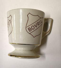 Warrnambool and District Historical Society Inc.
Domestic object - Bovril cup, c. 1950
This cup has been produced as a promotional item by the makers of Bovril, a meat extract paste usually used in cooking or stirred in hot water for a hot drink. It was developed in Britain in the 1870s and widely used during the depression of the 1930s and the World Wars when meat was scarce and expensive. Similar products such as Marmite (Britain) and Vegemite (Australia) have a vegetable rather than a meat base. This item is a memento of the times past when hot drinks made from meat or vegetable paste were very popular and it is retained for display purposes.This is a cream-coloured china cup with gold edgings and three gold-coloured Bovril logos (the name 'Bovril' inside a shield outline). The cup is mounted on a china base. Bovril Made in Englandmeat extract products, bovril, vintage china, bovril cup -
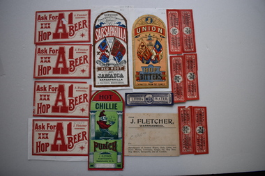 Warrnambool and District Historical Society Inc.
17 labels, J Fletcher, Early 20th century
In 1888 it was reported in "Victoria and its Metropolis" that John Fletcher carried on the business of a manufacturer of aerated waters, cordials, hop bitters, etc. in Warrnambool, and traded throughout the Western District. The establishment was started by a Mr. J. Davis with whom Mr. Fletcher was connected from its commencement, and whom he succeeded in 1885. His business continued until 1930. The Warrnambool and District Historical Society has a collection of bottles used by John Fletcher to contain his products. These labels are significant as John Fletcher was a most successful manufacturer of cordials and aerated waters in Warrnambool in the late 1800s and early 1900s .1 Buff coloured rectangular card label with black text. 2 Rectangular label with curved top adhered to a piece of white paper. It is coloured red, blue black and gold and features two standards and text. .3 Rectangular label with curved top adhered to the reverse of .2. It is coloured red and green and features a sketch of Punch carrying a bowl of a steaming substance and text .4 Rectangular label with curved top adhered to a piece of white paper. It is coloured red, apricot, dark and light blue, gold and black. It features the linked initials JF, two standards a trade mark and text .5 Rectangular label with curved top adhered to the reverse of .4 It is coloured red, blue, green, black and gold. It features two standards and text. .6 Identical to .3 but not adhered to paper .7,.8, .9 .10 White rectangular labels with red text. .9 has a damaged corner. .10 is adhered to a piece of white paper. .11,.12,.13,.14,.15..16 Red rectangular labels with black text and a coat of arms. .13 is adhered to a piece of pink card, .17 Blue rectangular label with text and a coat of arms .1 FROM J. FLETCHER, WARRNAMBOOL Manufacturer of Aerated Waters, Soda, Lithia and Tonic Waters, Lemonade, Ginger Ale, Hop beer, Hop Bitters, Sarsaparilla and all Cordials .2 SUPERIOR CONCENTATED COMPOUND EXTRACT OF SARSAPARILLA PREPARED FROM THE BEST RED ROOT OF JAMAICA SARSAPARILLA J. FLETCHER,WARRNAMBOOL .3 HOT CHILLIE PUNCH J. FLETCHER WARRNAMBOOL Approximately 26 Oz. .4 UNION TRADE MARK JOHN FLETCHER WARRNAMBOOL HOP BITTERS EXTRACTED FROM THE FLOWER .5 J FLETCHER WARRNAMBOOL SUPERIOR GREEN COLOURED WITH BURNT SUGAR GINGER CORDIAL .6 Identical to .3 .7,.8,.9,.10 ASK FOR XXX HOP A1 BEER J FLETCHER WARRNAMBOOL .11,.12,.13.14,.15.16 SODA WATER J Fletcher .17 LITHIA WATER J FLETCHER WARRNAMBOOL john fletcher, warnambool, cordials -
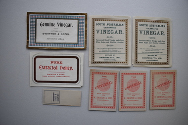 Warrnambool and District Historical Society Inc.
Labelsx8, Swinton, Early 20th century
William and Ann Swinton came to Warrnambool in 1854. William was a carpenter and established a general store in Warrnambool in 1865. By 1888 the firm was known as William Swinton & Sons. After William died in 1901 the business was known as Swintons Pty. Ltd. After 1934 there were two branches of the business, George Swinton & Son and Swintons Pty. Ltd. These labels are of interest because Swintons stores have been of utmost importance in Warrnambool's history.Today it is one of the oldest family businesses in Australia.1 Rectangular paper label with white inner rectangle with black text surrounded by dark green, checked red and dark green gold coloured borders.It is adhered to a piece of white paper. It is damaged. .2,.3 Rectangular paper cream labels with dark green text and gold coloured decorative borders. .4 Rectangular paper white label with red text surrounded by a brown and two thin black borders. It is damaged. .5,.6,.7 Rectangular cream coloured card with red text and a sphere surrounded by a decorative border. .8 White paper rectangular label with dark blue text. It has remnants of an adhesive on the back. .1 Genuine Vinegar BOTTLED BY SWINTON & SONS Approximately 25oz. .2 SOUTH AUSTRALIAN CELEBRATED VINEGAR . Fermented Mixed Vinegar made from Wine, Sugar, and Distilled Alcohol. Free of any addition of Commercial Acetic Acid, COLOURED WITH CARAMEL. Each Bottle contains approximately 22oz. BOTTLED BY SWINTONS PTY.LTD.WARRNAMBOOL .4 PURE Extracted Honey SWINTON & SONS TIMOR STREET WARRNAMBOOL .5,.6,.7 THE UNIVERSAL MADE EXPRESSLY FOR W SWINTON & SONS, WARRNAMBOOL Size.....Price..... .8 SWINTON & SONS WARRNAMBOOL -
Glen Eira Historical Society
Letter - Christian Family
Seven documents relating to the Day Dawn mine. Three pages of documentation on liquidation of Day Dawn mine. Photocopied extract from supplement published in1972 by Northern Miner on centenary of the founding of Charters Tower. Typewritten report on Charles Tower’s early days supplied by Charters Towers Historical Society, The Northern Liner. Handwritten note from Australian Stock Companies year book 1900 concerning Daydream P.C. Gold Mining Company Ltd. Letter from Queensland State Archives re T. Christian and Day Dawn P.C. mine to Mr. J. O’Donnell dated 17/08/1973.christian thomas, charters towers, day dawn mine, o’donnell j. mr., financial documents, mine and mining -
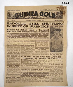 Bendigo Military Museum
Newspaper, "Guinea Gold", 3 Aug 1943
"Guinea Gold" newspaper was published during WW2 for Australian and American troops. The Australian version with Australian home news extracted from Australian newspaper.4 page newspaper (own broadsheet folded), yellow in colour with writing in black type set. Red stain in top right corner of page 1 and some small tears.Dated August 3, 1943, Vol 1 No.259. Contains detailed news items related to WW2. Page 2 Death notice for for P A Taylor circled in pen.guinea gold, newspaper, ww2 -
 Halls Gap & Grampians Historical Society
Photograph - B/W, C 1887
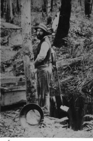
This is an extract/copy of an original photo that showed both Alfred and Charlie D'Alton together. (see Record # 127 for section with Alfred D'Alton and Record # 117 for the entire photo).Photo of Charles D'Alton looking for gold on Stoney Creek. people, d'alton, mining, stoney creek -
 Halls Gap & Grampians Historical Society
Photograph - B/W, C 1887
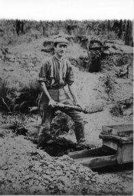
This is an extract/copy of an original photo that showed both Alfred and Charlie D'Alton together. (see Record # 126 for section with Charles D'Alton and Record # 117 for the entire photo).Photo of Alfred D'Alton looking for gold on Stoney Creek.people, d'alton, mining, stoney creek -
 Eltham District Historical Society Inc
Photograph, Edendale Farm, Eltham Heritage Tour, 24 May 1992, 24/05/1992
ELTHAM HERITAGE TOUR The Society excursion on 24th May 1992 was arranged by David Bick, leader of the team carrying out the Shire's heritage study. David selected a number of sites or buildings identified in the study, some of them lesser known components of the Shire's heritage. The tour commenced at the Eltham Shire Office at 10.00 am. Travel was by private car and mini-bus with stops at about twelve locations for commentary by David.It included a short walk in Hurstbridge and lunch at Kinglake. Highlights of the tour included: - 10 am Leave from Shire Offices - 3 Important Trees - A Physical Link to Eltham's First Settlers - Toorak Mansion Gates - A Surviving Farm House - An Intact Circa 1900 Main Street - First Settlers - Gold Miners, and Timber-getters - An Early Hotel - A Pioneering Homestead - Changing Eltham Shire - 20th Century - 4 pm Afternoon Tea and Finish Tour Extract from ELTHAM CULTURAL HERITAGE TOUR (Newsletter No. 85, July 1992, by Bettina Woodburn) "The land was unprofitable for intensive farming, but there was always water in the Diamond Creek. The railway, a technological advance, followed the valley, and was provided to transport produce. At North Eltham we were privileged to tour a surviving farmhouse of the 1860-70 era at the Shire’s Edendale Farm, with the as yet unfinished Sculpture for a front fence - bulbous tree-trunks decorated with salt pots, with cross members from the old trestle bridge. As was usual these six veranda posted houses faced South (or East, away from the sun!) with the scullery, kitchen and pantry "out the back". The veranda, which must have been very narrow, no longer exists. It probably wrapped around three sides. The drive took us past the Dutch Windmill, only twenty years old and in the Shire of Diamond Valley, then the Diamond Creek Cemetery with impressive gateway, to a detour to see another old farmhouse, isolated on a hill off Murray Road Wattle Glen. Here was a particularly thick patch of exotic planting of pines and cypresses. Subsistence farming no longer pays. Following the rail-line we noticed on the left near Silvan Road an Edwardian cottage and on the right near Yates Road the old school residence for this Upper Diamond Creek area."Record of the Society's history and activities and highlighting various aspects of the Heritage Study undertaken by David Bick used to create the future heritage overlay for the Shire of Eltham and later Nillumbik Shire.Roll of 35mm colour negative film, 4 stripsKodak Gold 100 5095eltham, shire of eltham historical society, activities, heritage tour -
 Eltham District Historical Society Inc
Photograph, Allwood House, Hurstbridge, Eltham Heritage Tour, 24 May 1992, 24/05/1992
ELTHAM HERITAGE TOUR The Society excursion on 24th May 1992 was arranged by David Bick, leader of the team carrying out the Shire's heritage study. David selected a number of sites or buildings identified in the study, some of them lesser known components of the Shire's heritage. The tour commenced at the Eltham Shire Office at 10.00 am. Travel was by private car and mini-bus with stops at about twelve locations for commentary by David.It included a short walk in Hurstbridge and lunch at Kinglake. Highlights of the tour included: - 10 am Leave from Shire Offices - 3 Important Trees - A Physical Link to Eltham's First Settlers - Toorak Mansion Gates - A Surviving Farm House - An Intact Circa 1900 Main Street - First Settlers - Gold Miners, and Timber-getters - An Early Hotel - A Pioneering Homestead - Changing Eltham Shire - 20th Century - 4 pm Afternoon Tea and Finish Tour Extract from ELTHAM CULTURAL HERITAGE TOUR (Newsletter No. 85, July 1992, by Bettina Woodburn) "At the crossroads stands Allwood House with its well laid out garden. The original owners, the Hurst family, ran a nursery; the aligned palms, the cactus clumps, the introduced trees and shrubs show the plants then in fashion. On the other corners stand an old corrugated iron garage; a restaurant, designed and built 1980, but by using old materials it tries to retain the rustic character of its surroundings; and open space where a two storied Wineshop/Saloon once stood. The old Bank, now in the grounds of Allwood House has been moved a few doors down the street."Record of the Society's history and activities and highlighting various aspects of the Heritage Study undertaken by David Bick used to create the future heritage overlay for the Shire of Eltham and later Nillumbik Shire.Roll of 35mm colour negative film, 4 stripsKodak Gold 100 5095shire of eltham historical society, activities, heritage tour, hurstbridge, allwood house