Showing 188 items
matching flood -- 1934
-
 Orbost & District Historical Society
black and white photographs, 1934
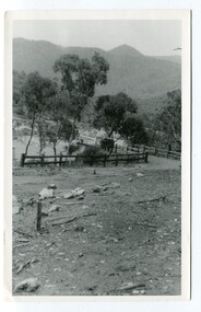
... McKillop's-Bridge Snowy-River flood-damage-1934... Bridge was completed after the flood damage. The current.... McKillop's-Bridge Snowy-River flood-damage-1934 Three black / white ...These photographs were taken just after the McKillop's Bridge was completed after the flood damage. The current McKillop’s Bridge was built by the Country Roads Board in two stages between 1931-36, during which its height was raised after the original bridge superstructure was washed away in record floods of January 1934, prior to its original official opening. In its reconstructed form the original concrete abutments were turned into additional piers and the welded-steel trusses were cantilevered back over them to meet the new higher road approaches. It is sited at McKillops Crossing, named after pioneer overlanding squatter George McKillop who crossed here in 1835. This was a stock crossing place for almost a century before the bridge was constructed. (info. from Victoria Heritage Register)This is a pictorial record of the history of McKillop's Bridge, in itself of historical significance for its association with Victoria's long and important pastoral history, its technicl significance and aesthetic significance.Three black / white photographs. 3133.1 shows the approach to a washed away bridge. 3133.2 is of a bridge over a river with men clearing debris. 3133.3 is a close-up showing the wreckage of the bridge.mckillop's-bridge snowy-river flood-damage-1934 -
 Kew Historical Society Inc
Photograph - Kane's Bridge on the Yarra River, December 1934
... Bridge. During the 1934 floods the bridge was washed downstream... in December 1934, when the 'great flood' of the Yarra caused...Inscribed verso: "Kane's Bridge Yarra in flood Dec 1934".... During the 1934 floods the bridge was washed downstream ...In 1928 a footbridge was erected to link Kew with the public golf course across the Yarra. The total cost of construction came to 250 pounds and the bridge became known as Kane's Bridge. During the 1934 floods the bridge was washed downstream, and was subsequently rebuilt. The present form of the bridge resembles the earlier bridge which crossed from the Yarra Bend Asylum to Kew, further upstream. (VHD)Original, black and white positive of Kane's Bridge in December 1934, when the 'great flood' of the Yarra caused the bridge's destruction. Inscribed verso: "Kane's Bridge Yarra in flood Dec 1934"river yarra, yarra -- kew (vic.), kanes bridge, 1934 floods -
 Kew Historical Society Inc
Plant specimen, Dorothy Rogers, Inscribed Moreton Bay Fig Leaves, Hawthorn (Vic), c.1960s
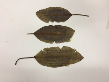
... 1934 flood - melbourne - hawthorn (vic)... of Derham St Haw - vicinity Palmer's Punt until 1934 flood & hut... (vic) palmer's punt invergowrie - hawthorn 1934 flood ...Collected by the historian Dorothy RogersDried Moreton Bay fig leaves from the vicinity of Palmer's Punt near Denham Street Hawthorn. Each leaf was inscribed by the historian Dorothy Rogers (sic) before 1973. The leaves are brittle and undated, with the text difficult to decipher. 1974.0010.1 "Moreton Bay fig leaf from old tree foot of Derham St Haw - vicinity Palmer's Punt until 1934 flood & hut for Punt passengers was still there. KH-355." 1974.0010.2 "Moreton Bay fig leaf from old tree foot of Denham St haw - vicinity Palmer's Punt until 1934 flood hut for punt passengers still existed there. A canoe tree in garden from Sir J. Palmer's land. KH-355." 1974.0010.3 "Moreton Bay fig leaf from old tree foot of Denham St leading to Palmer's Punt until 1934 flood there was still there a hut for punt passengers. Canoe tree in gardens from Sir J. Palmer's land. KH-355."denham street - hawthorn (vic), palmer's punt, invergowrie - hawthorn, 1934 flood - melbourne - hawthorn (vic) -
 Kew Historical Society Inc
Photograph, Floods in North Kew, 1934
... Floods in North Kew, 1934. Flood near the lagoon (Billabong?)... the Twentieth Century. floods (kew) 1934 yarra river Floods in North Kew ...Living with natural processes was frequently a challenge to early European settlers and later residents of what was in the 1850s administered by the Borondara Road Board. This was compounded by the area being bounded on three sides by rivers (Yarra River, Koonung Creek and Gardiner's Creek). In 1849, the historian James Bonwick recorded that "our district [Kew] suffered considerably. Mr Wade speaks of 80 acres, out of 100 acres of his cultivated paddock, covered by water." Newspapers continued to describe major flooding in Kew in 1863, 1869, 1878, 1880, 1889, 1891, 1916 and 1934. While the construction of the Upper Yarra dam in 1957 reduced the levels of flowing downstream, local and riverine floods continue.The Kew Historical Society's pictures and map collections testify to the impact of flooding in the district. They have historical importance in documenting the extent of flooding in the district and its affects on homes, services and recreation. Numerous photographs record flooding throughout the Twentieth Century.Floods in North Kew, 1934. Flood near the lagoon (Billabong?)floods (kew) 1934, yarra river -
 University of Melbourne, Burnley Campus Archives
Photograph - Black and white print, Aerial View of Burnley Campus c. 1930, c. 1934
... 1934 flood... at the time of the floods of 30 November 1934. ... view burnley campus 1934 flood Black and white photographs ...Black and white photographs. Aerial Views of Burnley Campus. Enlargements. (A) Heyington Bridge to South, Yarra River on North side. (B) Heyington Bridge at top of photograph i.e. reverse view of (A). (C) Original of (B) mounted on board. Probably taken at the time of the floods of 30 November 1934. heyington bridge, yarra river, aerial view, burnley campus, 1934 flood -
 University of Melbourne, Burnley Campus Archives
Photograph - Black and white print, Orchard After Flood, 1934
... On reverse, "Orchard after flood Dec 1934."...orchard yarra river floods 1934 fruit tree damage to roots ...Orchard after flood: shows soil washed away from roots around fruit treeOn reverse, "Orchard after flood Dec 1934."orchard, yarra river, floods, 1934, fruit tree, damage to roots -
 University of Melbourne, Burnley Campus Archives
Photograph - Black and white print, Orchard After Flood, 1934
... On reverse, "Orchard after flood Dec 1934."...orchard yarra river floods 1934 damage On reverse, "Orchard ...Black and white photograph. Orchard after flood: shows soil washed away. On reverse, "Orchard after flood Dec 1934."orchard, yarra river, floods, 1934, damage -
 University of Melbourne, Burnley Campus Archives
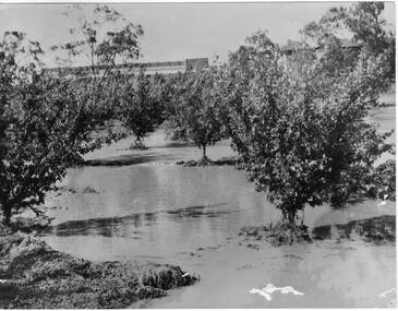
Photograph - Black and white print, Orchard in Flood, 1934
... On reverse, "Orchard Yarra River in flood Dec 1934."...orchard yarra river floods 1934 On reverse, "Orchard Yarra ...Black and white photograph. Orchard in floodOn reverse, "Orchard Yarra River in flood Dec 1934."orchard, yarra river, floods, 1934 -
 University of Melbourne, Burnley Campus Archives
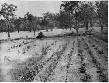
Photograph - Black and white print, Orchard in Flood, 1934
... On reverse, "Orchard Yarra River in flood Dec 1934."...orchard yarra river floods 1934 On reverse, "Orchard Yarra ...Black and white photograph. Orchard in flood. Seedlings planted in rows.On reverse, "Orchard Yarra River in flood Dec 1934."orchard, yarra river, floods, 1934 -
 University of Melbourne, Burnley Campus Archives
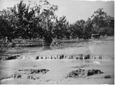
Photograph - Black and white print, Orchard in Flood, 1934
... On reverse, "Orchard Yarra River in flood Dec 1934."...orchard yarra river floods 1934 fruit trees On reverse ...Black and white photograph. Orchard in flood: shows fruit trees standing in water.On reverse, "Orchard Yarra River in flood Dec 1934."orchard, yarra river, floods, 1934, fruit trees -
 University of Melbourne, Burnley Campus Archives
Photograph - Black and white print, Orchard in Flood, 1934
... On reverse, "Orchard Yarra River in flood Dec 1934."...orchard yarra river floods 1934 On reverse, "Orchard Yarra ...Black and white photograph. Orchard in floodOn reverse, "Orchard Yarra River in flood Dec 1934."orchard, yarra river, floods, 1934 -
 Eltham District Historical Society Inc
Photograph, 1934 Floods at Eltham
... the Diamond Creek trail. In 1934 extensive flooding of the Yarra... A1678B Floods- Eltham - 1934... the Diamond Creek trail. In 1934 extensive flooding of the Yarra ...Published in the Diamond Creek Basin Study, 1980 and identified at Diamond Creek, locality not identified, 1934. The location is actually looking south across the Diamond Creek towards Falkiner Street, beside the Main Road bridge at Eltham South from what is now part of Wingrove Park opposite Antoinette Boulevard. The bridge railing is just visible to the left of image. The large leaning Manna Gum beside the bridge still stands in 2021 alongside the Diamond Creek trail. In 1934 extensive flooding of the Yarra River and Diamond Creek set new records for flood plain level (Eltham Chronology, EDHS)Black and white photographCopied by Hugh Fisher, Photographer, 6 York Street Eltham A1678B Floods- Eltham - 1934floods, yarra river, eltham, flooding, diamond creek, flood -
 Eltham District Historical Society Inc
Document - Folder, McLean, 1984-1999
... 1934 Flood... around the corner to the shortcut road when the 1934 floods... around the corner to the shortcut road when the 1934 floods ...References to McLean family, Hector John McLean and Louisa Frances (nee Green) and six daughters who lived in Eltham during the period 1930 to 1934 inclusive. Lived in the former Evelyn Hotel at the time it was destroyed by fire and being part of the Centenary Parade in 1934 where the family won the Group Section for their entry “Pioneers of Eltham” Reminiscences provided by Edith Jones (nee M1934 flood, ballroom, baptism, barber shop, bittern, boy scouts, bremner's flat, burgoyne's shop, cable tram, cemetery road, centenary celebrations, centenary parade, christening, coach house, collis grocery, dalton street, depression, dole, dorothy jean mclean, edith jones (nee mclean), eltham fire brigade, eltham high school, eltham higher elementary school, eltham lower park, eltham railway station, eltham state school no. 209, evelyn hotel, fire damage - buildings, flinders naval depot, fordham, gladys evelyn mclean, gold mining, gwenneth mae mclean, gwladys evelyn mclean, headmistress, hector john mclean, isherwood house and shop, louisa frances mclean (nee green), metery road, methodist church, miss finnin, miss grant cottage, motor bike races, mrs barrett, mrs bremner, mrs hurley, olive isabel mclean, parade, phoebe lillian mclean, picnic, pioneers of eltham, pitt street, research fire brigade, rev. r.g. arthur, shed, shops, st margarets church hall, st margaret's church, stables, state savings bank of victoria, susso books, todaro, vinnie willet, warrandyte bridge, warrandyte, wingrove park, yarra river -
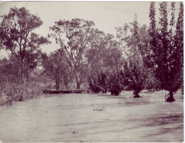
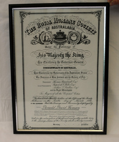 Orbost & District Historical Society
certificate/award, after 1934
... award certificate royal-humane-society flood snowy-river... royal-humane-society flood snowy-river 1934 thomson-david ...This certificate was presented to Donald David Thomson , sleeper hewer, aged 42 years for rescuing S.C. Curtis, aged 52, G. Wylie, aged 54, J. Dalgleish, aged 5 from flood waters at White gulch on the Snowy River on January 8, 1934. (The certificate reads as White's Gulch but should be Watt's gulch.) Although damage estimated at 500,000 pounds was caused by the unprecedented floods along the Snowy River, no lives were lost because of the courageous actions of men like Donald Thomson.A framed copy of a printed and hand-written certificate from the Royal Humane Society of Australia awarded to Donald David Thomson for rescuing victims of the floodwaters in Orbost January 1934. It is dated 6.3.1934.Printed at top of certificate: THE ROYAL HUMANE SOCIETY / OF AUSTRALASIA. Has names of Society patrons and committee as well as names and ages of those rescued. award certificate royal-humane-society flood snowy-river 1934 thomson-david -
 Yarra Glen & District Historical Society
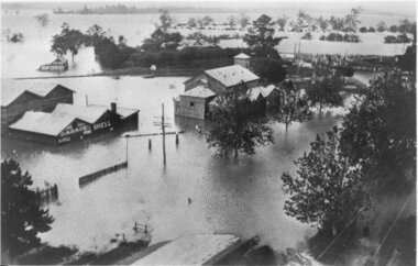
Black and white photographs, Flood waters in Yarra Glen December 1934
... 1934 flood...-ranges grand hotel victoria hall bell street floods 1934 1934 ...Black and white photograph of Bell street, Yarra Glen, taken in December 1934 from the tower of the Grand Hotel, looking south towards the railway crossing, during the floods. The Victoria Hall is the building in the centre of the photograph. Directly behind the Victoria Hall, the roof of 'River View' guest house can be seen. The Shell Garage, operated by Les Orenshaw, on the left of the photograph was originally built and occupied as a peg factory.The view extends from Bell street across the river flats with the high ground of Chateau Yering in the background. Bell Street is defined by the street trees where the water covers the road in the foreground grand hotel, victoria hall, bell street, floods 1934, 1934 flood, railway crossing, river view, guest house, shell garage, peg factory, river flats, chateau yering, les orenshaw, street trees -
 University of Melbourne, Burnley Campus Archives
Photograph - Black and white print, Flood in Orchard, 1934
... 1934 flood... ellery centenary celebrations orchard tom trahair 1934 flood alex ...This photograph was sent to Burnley in an envelope printed, "On His Majesty's Service" Centenary Celebrations State of Victoria & City of Melbourne 1934-35 Department of Agriculture, Melbourne and handwritten on it "Flood in orchard 1/12/1934 Mr. Jessep." Note by T.H. Kneen 8 April 1992, "Alex Jessep (left) with Tom Trahair. Periodically Tom would take leave to go back to his home town Yackandandah to test a new theory to find the lost gold seam at the Little Waterloo mine."Black and white photograph. George Russ and Frank Ellery examining the ground by the flooded river. Uprooted trees behind them.This photograph was sent to Burnley in an envelope printed, "On His Majesty's Service" Centenary Celebrations State of Victoria & City of Melbourne 1934-35 Department of Agriculture, Melbourne and handwritten on it "Flood in orchard 1/12/1934 Mr. Jessep."george russ, frank ellery, centenary celebrations, orchard, tom trahair, 1934 flood, alex jessep, uprooted trees -
 Eltham District Historical Society Inc
Document - Folder, Orford family
... 1934 Flood... Le Pine Funeral Home Life Member Order of Service 1934 Flood ...The Orford family, a pioneer family remained continuously living and working in Eltham for 170 years from 1854 to 2024. James and Sarah Orford arrived in Sydney in 1839 aboard the ship “Orestes”; they had several children there before settling in Eltham in 1854. Three children, James Mathias, Sarah Amelia and Thomas Henry initially remained in the Eltham area. James eventually moved to Brunswick. Sarah married Arthur Butler Young and finally lived in Bunyip. Thomas who was six years old when the family arrived in 1854 remained in Eltham, married Helen Logan who died, leaving a large family. They lived in a slab hut by the Yarra at Laughing Waters and Thomas managed the Panton Park Estate, a selection owned by Magistrate Thomas Panton. Thomas’s son, Ernest Orford was born 1892 at Pitt Street, Eltham and also lived his entire life in Eltham working as a labourer, orchardist and later as a gardener and grounds keeper for Sir William Irvine, a former Chief Justice and Premier of Victoria. Ernest married Kate Thomas; their two sons Ron and Doug stayed in the area. Another of Thomas' sons, Arthur, also lived in Eltham. Four Orford generations attended Eltham schools. Doug Orford was born on the kitchen table (reference, son Ted Orford) of the family home at the corner of Reynolds Road and Mount Pleasant Road. Doug married Gwen and they established a family however Gwen died at a young age from cancer. Doug eventually remarried another Gwen and they lived for several decades in Napoleon Street, Eltham. Doug was actively involved in EDHS over many years, including serving as a committee member and vice president. Contributions by Doug and Gwen (Treasurer/Membership Secretary), his wife, assisted EDHS to continue to develop as a not-for-profit group intent on promoting and preserving our local history. Both Doug and Gwen were made Life Members of EDHS. They also acted as EDHS delegates to the Eastern Region of Historical Societies. His significant work with assisting to establish our valued Local History Centre helped develop our home base and supported the continued growth of our society. Doug’s local knowledge, suggestions and family connections were highly valued, Until recent times, he continued to regularly attend our Collections Team workshops providing his insights and historical information about photographs and society records. Doug died peacefully July 8, 2024, and represents the last link in the Orford Eltham chain which spanned 170 years. His funeral was held Thursday, July 18, 2024, at Le Pine Funerals, 848 Main Road, Eltham. Contents: Typed notes, no date: Memories of Ernest Orford [taped 1979] about his school days. Handwritten notes, no date: History of Ernie Orford Typed notes, no date: History of Thomas Henry Orford and family. Photocopy: Shire of Eltham General Rate Receipts. Received from D Orford 7 June 1923 and Received from E F Orford, 4 August 1924. Letter, no date: Nillumbik Shire to Russell Yeoman, Gwen Orford to receive Volunteer Recognition Award. Newsletter article: "The Orford Family, Eltham", Shire of Eltham Historical Society, No.80 September 1991. History of Orford family. Handwritten notes: 21 March 2011, genealogy of George Orford. On reverse Melways map makred with Orford and other land ownerships. Newspaper advertisement, 21 March 2011: "264 Reynolds Road, South Eltham", property for sale [land in ownership of Orford family]. Letter: St Margaret's Anglican Church Eltham to Doug Orford, 17 November 2011, Extracts from church records relative to Orford family. Newspaper article: "Timely facelift at war memorials', Diamond Valley Leader, 30 April 2024, Nillumbik war memorial will have some work and a bronze plaque will be installed at the Eltham Avenue of Honour, Wingrove Park; photograph of Doug Orford Newsletter item: "Welcome home medal", Eltham District Historical Society newsletter no.216 May 2014, World War I two 'Welcome Home Medals' in ownership of local men, being Harry Gilham and Doug Orford. Order of Service, Le Pine Funerals (Eltham), In Loving Memory of Douglas Frederick Orford 22nd August 1929 - 8th July 2024 Doug Orford Reminiscences (2002) in conjunction with Jock Read and Peter Bassett Smith; 4 pages - 3 typed, 1 handwritten possibly transcribed from an audio tape recording (location unknown). New word file and associated pdf created [\Dropbox\EDHS DATA\DOCUMENTS\COLLECTION CATALOGUE DOCUMENTS AND PDFs\2-2 Family Folders\EDHS_06110-2 Doug Orford reminiscences 2002.docx - 1 April 2025]Newspaper clippings, A4 photocopies, etcdoug orford, harry gilham, welcome home medal, eltham avenue of honour, nillumbik war memorial, wingrove park, henry dendy, alfred armstrong, james orford, 264 reynolds road south eltham, george orford, george joseph orford, maryanne george joseph, thomas henry orford, ernest orford, e f orford, eltham cemetery, helen orford, joseph panton, panton park, gordon lyon, banyule estate heidelberg, james matthias orford, wurundjeri, constable peter lawlor, george hill, franklin street eltham, ronald orford, eltham primary school, john brown, robert gamble school inspector, sarah orford, mary ann orford, james mathias orford, sarah amelia orford, james peet, arthur butler young, watsons creek victoria, kangaroo ground victoria, helen logan, william orford, jane orford, arthur orford, frederick orford, florrie orford, victor orford, chem orford, sunnymede eltham, panton hill estate, sir william irvine, gordon lyons, kate thomas, north eltham gospel church, harold clapp, eltham cricket club, research primary school, dalton street school eltham, keith banks, betty banks, benjamine boyd, laughing waters road eltham, freddie gilsinen, douglas frederick orford, eltham district historical society, funeral service, le pine funeral home, life member, order of service, 1934 flood, 1939 bushfires, alcock & pierce, ansell, associated schools sports, blacksmith shop, boakes, bridge street, bryce family, bullock track, butcher, catholic church, cliff lester, cliffy green, daisy smith, dave lyon, diamond creek, diana bassett smith, dick tooth, dr. frank may, eltham higher elementary school, ernie andrew, fire station, flower stall, fodder business, fruit shop, furniture store, gahan family, garni burges, greensborough, harold norman, harry hawker, hat factory, hawker & owen, hay and com store, henry hawker, henry street, j .harry butherway, jack burgoyne, jack ryan, jock read, john lyon, junk yard, kevin gahan, kilpatricks, len parsons, lyon family, machine factory, mc leans, memorial, metery road, miss reynolds, monteith 's bus, mr. gadd, mrs. bird, mrs. morrison, napoleon street, peter bassett smith, peter's gahan, plenty river, plumridge, produce store, public hall, rechabite hall, reynolds road, roger bird, rutter family, ryan family, shoe factory., staffs produce store, studley cairn gahan, sweeneys lane, swimming pool, taylor street, tennis court, warren family, wooden bridge, yarra brae road -
 University of Melbourne, Burnley Campus Archives
Document, Improvements (Completed files), 1925-1935
... Correspondence mainly re drainage, repairs after 1934... Correspondence mainly re drainage, repairs after 1934 floods. etc ...Correspondence mainly re drainage, repairs after 1934 floods. etc.drainage, repairs, floods, improvements -
University of Melbourne, Burnley Campus Archives
Slide, Alan L. Mitchell, 1934
... Floods in Orchard 1934 from Yarra River.... orchard Floods in Orchard 1934 from Yarra River. Slide Alan L ...Floods in Orchard 1934 from Yarra River.alan l. mitchell, burnley gardens, floods, orchard -
 Kew Historical Society Inc
Photograph - Yarra in Flood, 1934
... and 1934. While floods continued after the development of the Upper...Black and white print positive. 1934 floods of the Yarra... following the floods of 1916, 1921 and 1934. While floods continued ...Flooding of the Yarra Valley, including that section of the Yarra bordering Kew and Kew East in the north and west of the municipality, was a regular occurrence. Extreme flood events of the Yarra River are recorded to have occurred in 1891, 1901, 1916, 1923 and 1934. The Municipality of Kew's response to these floods was to enact planning decisions restricting residential development in flood prone areas following the floods of 1916, 1921 and 1934. While floods continued after the development of the Upper Yarra Reservoir (construction 1948-57), the regularity and extent of these inundations diminished.Black and white print positive. 1934 floods of the Yarra Valley. Location Fairfield looking towards wooded hillside. Houses floating in river.Reverse: "From Fairfield Park (11936?) back towards hill (Wurundjeri Spur?)"floods -- 1934, yarra valley, yarra river, fairfield park -
 Clunes Museum
Photograph, FLOODS 1934
... BLACK AND WHITE SMALL PHOTOGRAPH OF CLUNES FLOODS IN 1934.... local history queen's park garden. FLOODS 1934 BLACK AND WHITE ...AFTER HEAVY RAINS - CRESWICK CREEK IN CLUNES TOWNSHIP FLOODED, OVER FLOWING ITS BANKS, NEAR BY AREAS WERE SUBMERGED.BLACK AND WHITE SMALL PHOTOGRAPH OF CLUNES FLOODS IN 1934. CLUNES QUEEN'S PARK WITH FOUNTAIN UNDER WATER - TREES IN THE BACKGROUND AND A FEW FLOWERS IN THE FOREGROUND.local history, queen's park garden., floods 1934 -
 Kew Historical Society Inc
Photograph, Floods in North Kew, 1934
... Floods in North Kew, 1934. Vicinity of Willsmere Park.... the Twentieth Century. floods (kew) Floods in North Kew, 1934. Vicinity ...Living with natural processes was frequently a challenge to early European settlers and later residents of what was in the 1850s administered by the Borondara Road Board. This was compounded by the area being bounded on three sides by rivers (Yarra River, Koonung Creek and Gardiner's Creek). In 1849, the historian James Bonwick recorded that "our district [Kew] suffered considerably. Mr Wade speaks of 80 acres, out of 100 acres of his cultivated paddock, covered by water." Newspapers continued to describe major flooding in Kew in 1863, 1869, 1878, 1880, 1889, 1891, 1916 and 1934. While the construction of the Upper Yarra dam in 1957 reduced the levels of flowing downstream, local and riverine floods continue.The Kew Historical Society's pictures and map collections testify to the impact of flooding in the district. They have historical importance in documenting the extent of flooding in the district and its affects on homes, services and recreation. Numerous photographs record flooding throughout the Twentieth Century.Floods in North Kew, 1934. Vicinity of Willsmere Park.floods (kew) -
 Kew Historical Society Inc
Photograph, Burke Road Bridge, 1930s
... was submerged beneath the flood waters in the 1934 mega-flood..., constructed in 1926 was submerged beneath the flood waters in the 1934 ...Without bridges, Kew remained cut off from the City of Melbourne, only being accessible by Punt. Private and public bridges were constructed from the 1850s, beginning with the Hawthorn Bridge linking Bridge and Burwood Roads. A bridge across the Yarra at Burke Road was created as early as 1873. Since that first wooden bridge, a number of later bridges, typically on concrete pylons have been built, in 1926 and again during the 1970s.Sepia, faded photograph of the Burke Road Bridge linking East Kew and Ivanhoe. The previous bridge, constructed in 1926 was submerged beneath the flood waters in the 1934 mega-flood of the Yarra.burke road bridge (kew), bridges -- river yarra -
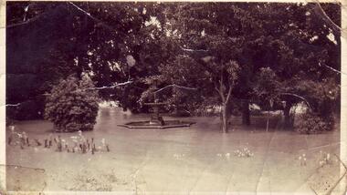
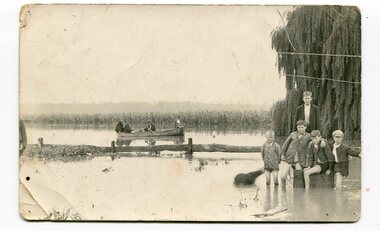 Orbost & District Historical Society
black and white photograph, 1934
... This photograph was taken during the flood of 1934... gippsland This photograph was taken during the flood of 1934 ...This photograph was taken during the flood of 1934 in Orbost. The people in the photograph are related to Billie and Ilma Nixon and Charlie Johnston. Damage estimated at £500,000 was caused by the 1934 floods in the Orbost district. This 1934 flood was devastating, destroying a section of the 1922 Orbost bridge, wrecking fences, bridges and roads, dumping silt and debris on the rich river flats and drowning cattle.This item is a pictorial record of a significant event in Orbost's history. It is associated with local families.A black / white photograph / postcard of floodwaters. On the right is a young man with four young boys sitting on a log. In the bckground is a rowing boat with one man rowing and three others sitting on the edges . A field of maize / corn is in the background and a large willow tree on the right.on back - "M. C. Rice Orbost 19 /1/20 M Gilbert. Mostly Billy Nixons & Charlie Johnstons 1934" [Note alteration: W C Rice rather than M C Rice].floods-orbost-1934 nixon-william johnston-charles -
 Kew Historical Society Inc
Photograph, Floods in North Kew, 1934
... Floods in North Kew, 1934. Chipperfield's Boat House under... the Twentieth Century. floods (kew) 1934 yarra river chipperfield's boat ...Living with natural processes was frequently a challenge to early European settlers and later residents of what was in the 1850s administered by the Borondara Road Board. This was compounded by the area being bounded on three sides by rivers (Yarra River, Koonung Creek and Gardiner's Creek). In 1849, the historian James Bonwick recorded that "our district [Kew] suffered considerably. Mr Wade speaks of 80 acres, out of 100 acres of his cultivated paddock, covered by water." Newspapers continued to describe major flooding in Kew in 1863, 1869, 1878, 1880, 1889, 1891, 1916 and 1934. While the construction of the Upper Yarra dam in 1957 reduced the levels of flowing downstream, local and riverine floods continue.The Kew Historical Society's pictures and map collections testify to the impact of flooding in the district. They have historical importance in documenting the extent of flooding in the district and its affects on homes, services and recreation. Numerous photographs record flooding throughout the Twentieth Century.Floods in North Kew, 1934. Chipperfield's Boat House under flood.floods (kew) 1934, yarra river, chipperfield's boat house -
 Kew Historical Society Inc
Photograph - Flood at Fairfield Park, 1934
... and 1934. While floods continued after the development of the Upper... in 1934. Major flood resulting in submerged buildings in middle... following the floods of 1916, 1921 and 1934. While floods continued ...Flooding of the Yarra Valley, including that section of the Yarra bordering Kew and Kew East in the north and west of the municipality, was a regular occurrence. Extreme flood events of the Yarra River are recorded to have occurred in 1891, 1901, 1916, 1923 and 1934. The Municipality of Kew's response to these floods was to enact planning decisions restricting residential development in flood prone areas following the floods of 1916, 1921 and 1934. While floods continued after the development of the Upper Yarra Reservoir (construction 1948-57), the regularity and extent of these inundations diminished.Black and white print positive. Yarra River at Fairfield in 1934. Major flood resulting in submerged buildings in middle ground and onlookers on far bankReverse: "Flood of Yarra at Fairfield Park 1934"fairfield park, yarra valley, river yarra, floods -- 1934 -
 Kew Historical Society Inc
Photograph, Floods in North Kew, 1934
... Floods in North Kew, 1934. Unidentified location... the Twentieth Century. floods (kew) 1934 yarra river Floods in North Kew ...Living with natural processes was frequently a challenge to early European settlers and later residents of what was in the 1850s administered by the Borondara Road Board. This was compounded by the area being bounded on three sides by rivers (Yarra River, Koonung Creek and Gardiner's Creek). In 1849, the historian James Bonwick recorded that "our district [Kew] suffered considerably. Mr Wade speaks of 80 acres, out of 100 acres of his cultivated paddock, covered by water." Newspapers continued to describe major flooding in Kew in 1863, 1869, 1878, 1880, 1889, 1891, 1916 and 1934. While the construction of the Upper Yarra dam in 1957 reduced the levels of flowing downstream, local and riverine floods continue.The Kew Historical Society's pictures and map collections testify to the impact of flooding in the district. They have historical importance in documenting the extent of flooding in the district and its affects on homes, services and recreation. Numerous photographs record flooding throughout the Twentieth Century.Floods in North Kew, 1934. Unidentified location on the Yarra Flood Plain at Kew.floods (kew) 1934, yarra river -
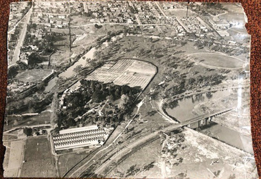 University of Melbourne, Burnley Campus Archives
Photograph - Black and white print, Airspy, Aerial View of Burnley Campus c. 1930, c. 1930
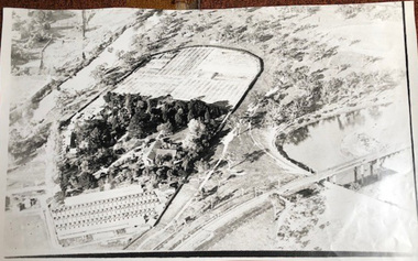
... the flood of 1934. Therefore probably 1929-1934. Information..., and probably before the flood of 1934. Therefore probably 1929-1934 ...Taken before the Boulevard was built, and probably before the flood of 1934. Therefore probably 1929-1934. Information provided by TH Kneen and EB LittlejohnColour photograph of black and white photograph. Photograph of Burnley Campus and large area of surrounding suburbs of Hawthorn and Toorak. It shows the Carter Oval, later modified, the Plant Research Institute (built 1929) and the Box Thorn Hedge (Lycium ferrocissimum).burnley campus, suburbs, hawthorn, toorak, carter oval, plant research institute, boxthorn hedge, lycium ferrocissimum -
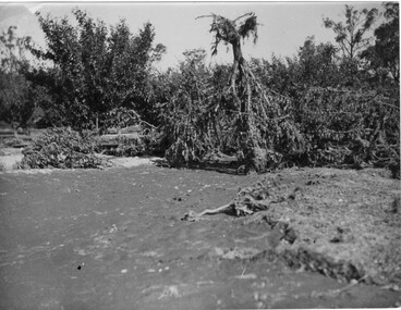 University of Melbourne, Burnley Campus Archives
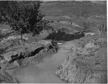
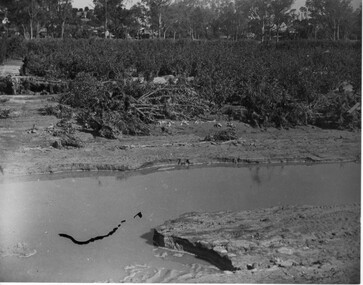
Photograph - Black and white print, A.P. Winzenried, Flood Damage, 1934
... in the Burnley orchards by the 1934 flood of the Yarra River. One large... garden a.p. winzenried flood damage fruit trees On reverse, "1934 ...Appears as an illustration in, "Green Grows Our Garden," A.P. Winzenried p 66. On p. 66 of the text there is further information about the effects of the flood.Black and white photograph. Destruction caused in the Burnley orchards by the 1934 flood of the Yarra River. One large tree is upside down with its roots in the air.On reverse, "1934."orchard, green grows our garden, a.p. winzenried, flood damage, fruit trees -
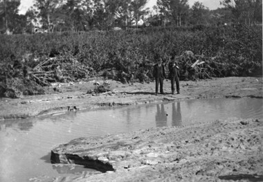
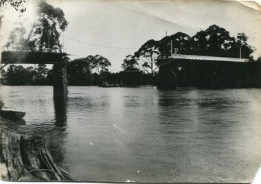 Orbost & District Historical Society
black and white photograph, January 1934
... Damage estimated at £500,000 was caused by the 1934 floods... gippsland Damage estimated at £500,000 was caused by the 1934 floods ...Damage estimated at £500,000 was caused by the 1934 floods in the Orbost district. This 1934 flood was devastating, destroying a section of the 1922 Orbost bridge, wrecking fences, bridges and roads, dumping silt and debris on the rich river flats and drowning cattle. The centre span of the Orbost Bridge was washed away. This item is a pictorial record of the 1934 floods, a significant part of Orbost's history.A black / white photograph showing the flood damage to the Snowy River Bridge. There is a gap in the bridge where the centre span has been washed away. In the background is a punt.orbost-floods-1934 natural-disasters-floods snowy-river-bridge