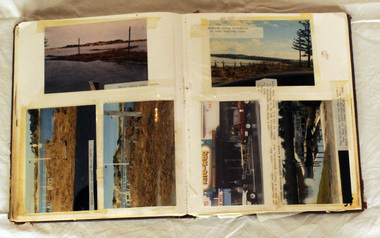
Showing 1940 items matching "floods"
-
 Kew Historical Society Inc
Photograph, Floods in North Kew, 1971
... Floods in North Kew ...Living with natural processes was frequently a challenge to early European settlers and later residents of what was in the 1850s administered by the Borondara Road Board. This was compounded by the area being bounded on three sides by rivers (Yarra River, Koonung Creek and Gardiner's Creek). In 1849, the historian James Bonwick recorded that "our district [Kew] suffered considerably. Mr Wade speaks of 80 acres, out of 100 acres of his cultivated paddock, covered by water." Newspapers continued to describe major flooding in Kew in 1863, 1869, 1878, 1880, 1889, 1891, 1916 and 1934. While the construction of the Upper Yarra dam in 1957 reduced the levels of flowing downstream, local and riverine floods continue.The Kew Historical Society's pictures and map collections testify to the impact of flooding in the district. They have historical importance in documenting the extent of flooding in the district and its affects on homes, services and recreation. Numerous photographs record flooding throughout the Twentieth Century.Floods in North Kew, 1971. Looking northeast towards Kilby Road from River Avenue. Annotation on reverse: map and date "8 Nov. 71 10.30am".floods (kew), yarra river, kew flood, kilby road flood -
 Eltham District Historical Society Inc
Photograph, Diamond Creek floods 1953, 1953
... Diamond Creek floods 1953...floods ...Three photographs of Diamond Creek in flood 21/10/1953 showing concrete bridge, Eltham South, Diamond Street bridge and Glen Park bridgediamond creek, floods, eltham, bridges, main road, wattletree road, diamond street, glen park -
 Eltham District Historical Society Inc
Photograph, Eltham - Floods in 1934
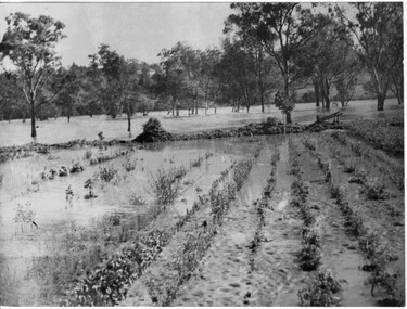
... Eltham - Floods in 1934...floods ...To the left of picture is the Main Road Bridge over the Diamond Creek in Eltham South when the Diamond Creek was in flood. The Yarra also was in flood. In early December 1934 the "Greatest flood in the history of the Yarra" occured, according to The Argus newspaper. Bridges and houses were swept away with hundreds of people left homeless across the state. The historic 1934 flood of the Diamond Creek and Yarra River set the criteria for future planning with respect to flood water rise.This photo forms part of a collection of photographs gathered by the Shire of Eltham for their centenary project book, "Pioneers and Painters: 100 years of the Shire of Eltham" by Alan Marshall (1971). The collection of over 500 images is held in partnership between Eltham District Historical Society and Yarra Plenty Regional Library (Eltham Library) and is now formally known as 'The Shire of Eltham Pioneers Photograph Collection.' It is significant in being the first community sourced collection representing the places and people of the Shire's first one hundred years.Digital image 4 x 5 inch B&W Negsepp, shire of eltham pioneers photograph collection, eltham, diamond creek (river), 1934 flood, diamond creek, floods, main road bridge -
 Eltham District Historical Society Inc
Photograph, Leader Publishing Co, Floods at Diamond Creek, Sep. 1924
... Floods at Diamond Creek...floods ...The Diamond Creek in flood in Diamond Creek township. View north along Diamond Street. The building in the middle distance is the Methodist Church. From "The Leader", 6 September 1924.This photo forms part of a collection of photographs gathered by the Shire of Eltham for their centenary project book, "Pioneers and Painters: 100 years of the Shire of Eltham" by Alan Marshall (1971). The collection of over 500 images is held in partnership between Eltham District Historical Society and Yarra Plenty Regional Library (Eltham Library) and is now formally known as 'The Shire of Eltham Pioneers Photograph Collection.' It is significant in being the first community sourced collection representing the places and people of the Shire's first one hundred years.Digital imageshire of eltham pioneers photograph collection, diamond creek, floods, methodist church, diamond creek (creek), diamond street, 1924 -
 Kew Historical Society Inc
Photograph, Floods, North Kew, 1923
... Floods, North Kew ...Floods in North Kew in the vicinity of Willsmere Park, donated by Kerry Woollard.floods (kew), yarra river -
 Kew Historical Society Inc
Photograph, Willsmere Bridge, 1934
Several boathouses were built in Kew and Fairfield in the late 19th and early 20th centuries. They included Chipperfield’s ‘Moorings’ and floating pontoon. The substantial two-storey house was named the Moorings, and incorporated an upper storey residence. The Moorings was almost washed away in the 1916 floods, and in 1934 almost totally submerged when the Yarra River rose 26 feet in 14 hours. Following the 1934 flood, the house was restored. The floating pontoon, sometimes referred to as a ‘kiosk’ or ‘canteen’, was used to store canoes. Both were removed in 1972 for the construction of the Eastern Freeway.This work forms part of the collection assembled by the historian Dorothy Rogers, that was donated to the Kew Historical Society by her son John Rogers in 2015. The manuscripts, photographs, maps, and documents were sourced by her from both family and local collections or produced as references for her print publications. Many were directly used by Rogers in writing ‘Lovely Old Homes of Kew’ (1961) and 'A History of Kew' (1973), or the numerous articles on local history that she produced for suburban newspapers. Most of the photographs in the collection include detailed annotations in her hand. The Rogers Collection provides a comprehensive insight into the working habits of a historian in the 1960s and 1970s. Together it forms the largest privately-donated collection within the archives of the Kew Historical Society.A view of flooded areas in North Kew in the flood of 1934.Willsmere Bridge. Chipperfields. 1934 floodwillsmere, flood, yarra flood, chipperfields, chipperfields boathouse, north kew -
 Upper Yarra Museum
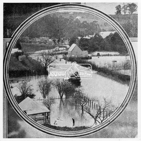
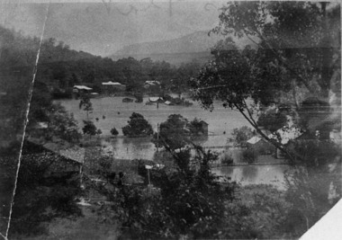
Negative Photographic Reproduction, Floods at Kelly’s flat 1933, Warburton
... Floods at Kelly’s flat 1933, Warburton ...Floods at Kelly’s flat 1933, Warburton Negative Black white Scanned at 600 dpi -
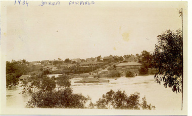 Kew Historical Society Inc
Photograph, Yarra at Fairfield, 1934 Floods, 1934
... Yarra at Fairfield, 1934 Floods ...One of three digital copies of flooded areas of Kew (1923-34), donated by Jan Coutts of Bulleen in 2019. The handwriting on the originals predates the copy.1934 YARRA FAIRFIELD FROM OPPOSITE RUDDER GRANGE floods - kew - 1934 -
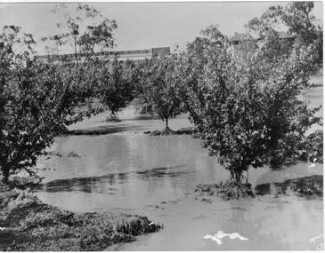
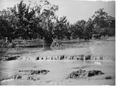 University of Melbourne, Burnley Campus Archives
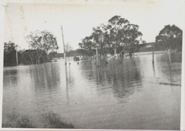
Photograph - Black and white print, Orchard in Flood, 1934
... floods ...Black and white photograph. Orchard in floodOn reverse, "Orchard Yarra River in flood Dec 1934."orchard, yarra river, floods, 1934 -
 University of Melbourne, Burnley Campus Archives
Photograph - Black and white print, Orchard in Flood, 1934
... floods ...Black and white photograph. Orchard in floodOn reverse, "Orchard Yarra River in flood Dec 1934."orchard, yarra river, floods, 1934 -
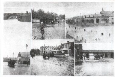 Melbourne Tram Museum
Photograph - Melbourne Flood scenes, 1910c
... floods ...Composite photograph from a journal showing six flood scenes in the South Melbourne and Port Melbourne area - undated. Photo No. 6 has been identified as Crockford St Port Melbourne. The image with the bridge is possibly Montague St. The photo on the left with a horse drawn cart, has the factory of Jones and Dunn Furniture Manufacturers.Yields information about a flood in the Port Melbourne area.Composite photograph of flood scenes in Melbourne - undated.Melbourne – Floods in the suburbs, No. 6 Crockford St Port Melbourne. Copy neg Mark Plummer collections ex late John Alfred collection.cable trams, melbourne, floods, crockford st, port melbourne, bridges, south melbourne -
Tatura Irrigation & Wartime Camps Museum
Photograph, 1955 Tatura Floods, 2001
... 1955 Tatura Floods ...In 1955 Ross Street North had to be cut to allow flood waters to relieve the flooding of the Tatura Township. The Midland Highway west of the Tatura Undera Road was cut by flood waters.floods 1955, ross st, midland highway, hogan's farm, baldwin road, photograph, people -
 Kew Historical Society Inc
Photograph - Flooding of the Yarra Valley at Kew East, 1974
... floods ...Flooding of the Yarra Valley, including that section of the Yarra bordering Kew and Kew East in the north and west of the municipality, was a regular occurrence. Extreme flood events of the Yarra River are recorded to have occurred in 1891, 1901, 1916, 1923 and 1934. The Municipality of Kew's response to these floods was to enact planning decisions restricting residential development in flood prone areas following the floods of 1916, 1921 and 1934. While floods continued after the development of the Upper Yarra Reservoir (construction 1948-57), the regularity and extent of these inundations diminished. During the nineteenth century, the land abutting the south side of the Yarra in Kew was devoted to dairy farming. In the twentieth century, before and after the construction of the Eastern Freeway, much of this low-lying area was used as golf courses and public parks.Late example of the capacity of the Yarra Valley at Kew to flood, even though drainage works and the Upper Yarra Reservoir had reduced their regularity.Original black and white print photograph of the low-lying land at East Kew under floodwater on 16 May 1974. The vantage point of the photographer is Lister Street. Flooding was caused by overflowing water in Glass' Creek and the River Yarra. Annotation verso: "Lister Street looking north / Flood level / 16 May 1974 11.30am / R.L. 46.04"hays paddock, floods, yarra river, glass' creek, lister street -
 Orbost & District Historical Society
album, Our Natural Disasters Hailstorm 1991 Floods 1934-1998, between 1998 and 2003?
... Our Natural Disasters Hailstorm 1991 Floods 1934-1998 ...This album was compiled for the use of visitors to the Slab Hut (Orbost Visitor Information Centre).This album is a useful research tool.A photo album with a maroon cover with gold embossing. On the cover is the title Our Natural Disasters. It contains 54 pages of photos of local natural disasters - flood, fire and hail. The photos are taped in.slab-hut orbost-disasters album orbost-floods-fires-hailstorms -
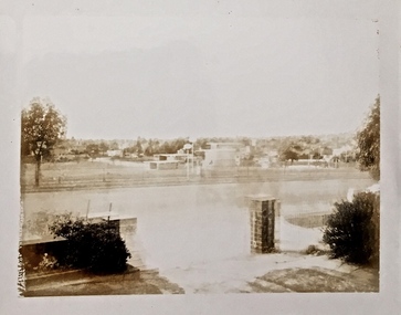
 Kew Historical Society Inc
Photograph - River Yarra in Flood from Kilby Road
Flooding of the Yarra Valley, including that section of the Yarra bordering Kew and Kew East in the north and west of the municipality, was a regular occurrence. Extreme flood events of the Yarra River are recorded to have occurred in 1891, 1901, 1916, 1923 and 1934. The Municipality of Kew's response to these floods was to enact planning decisions restricting residential development in flood prone areas following the floods of 1916, 1921 and 1934. While floods continued after the development of the Upper Yarra Reservoir (construction 1948-57), the regularity and extent of these inundations diminished.Print copy of an original photo of the River Yarra in Flood, taken from Kilby Road.VIEW ACROSS YARRA IN FLOOD / FROM KILBY RD KEWkilby road, floods -- kew (vic.), kilby farm -
 University of Melbourne, Burnley Campus Archives
Photograph - Black and white print, Orchard in Flood, 1934
... floods ...Black and white photograph. Orchard in flood. Seedlings planted in rows.On reverse, "Orchard Yarra River in flood Dec 1934."orchard, yarra river, floods, 1934 -
 Kew Historical Society Inc
Photograph - Yarra Valley Floods: Kew East, 1916
Flooding of the Yarra Valley, including that section of the Yarra bordering Kew and Kew East in the north and west of the municipality, was a regular occurrence. Extreme flood events of the Yarra River are recorded to have occurred in 1891, 1901, 1916, 1923 and 1934. The Municipality of Kew's response to these floods was to enact planning decisions restricting residential development in flood prone areas following the floods of 1916, 1921 and 1934. While floods continued after the development of the Upper Yarra Reservoir (construction 1948-57), the regularity and extent of these inundations diminished. During the nineteenth century, the land abutting the south side of the Yarra in Kew was devoted to dairy farming. In the twentieth century, before and after the construction of the Eastern Freeway, much of this low-lying area was used as golf courses and public parks.One of a collection of photographs of flooding in the Kew section of the Yarra Valley which are in important research resource for the location and extent of flooding in the first half of the twentieth century. Flooding of the Yarra Valley at East Kew in 1916. The view is taken from a street (maybe Birdwood Avenue) intersecting with Kilby Road looking northeast across the flood waters to Ivanhoe and Heidelberg. The extensive flooded area shown in the photograph would have included remnant dairy farms and the Kew Golf Club. Verso: "Floods / Yarra River / East Kew / Kilby Road / 1917? / 87"yarra river, yarra valley, floods -- kew, kilby road -- kew (vic.), kew golf club -
 Kew Historical Society Inc
Photograph - Yarra Valley Floods: Kew East, 1916
Flooding of the Yarra Valley, including that section of the Yarra bordering Kew and Kew East in the north and west of the municipality, was a regular occurrence. Extreme flood events of the Yarra River are recorded to have occurred in 1891, 1901, 1916, 1923 and 1934. The Municipality of Kew's response to these floods was to enact planning decisions restricting residential development in flood prone areas following the floods of 1916, 1921 and 1934. While floods continued after the development of the Upper Yarra Reservoir (construction 1948-57), the regularity and extent of these inundations diminished. During the nineteenth century, the land abutting the south side of the Yarra in Kew was devoted to dairy farming. In the twentieth century, before and after the construction of the Eastern Freeway, much of this low-lying area was used as golf courses and public parks.One of a collection of photographs of flooding in the Kew section of the Yarra Valley which are in important research resource for the location and extent of flooding in the first half of the twentieth century. Flooding of the Yarra Valley at East Kew in 1916. The view is taken from the intersection of Kilby Road with what is believed to be Birdwood Street, looking across the flood waters to Ivanhoe. The extensive flooded area shown in the photograph would have included the Kew Golf Club. Verso: "Floods along Kilby Road / near Birdwood St? & Kilby Road / 1917? / 87yarra river, yarra valley, floods -- kew, kilby road -- kew (vic.), kew golf club -
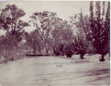
 Kew Historical Society Inc
Photograph - Flood at Fairfield Park, 1934
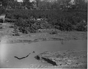
Flooding of the Yarra Valley, including that section of the Yarra bordering Kew and Kew East in the north and west of the municipality, was a regular occurrence. Extreme flood events of the Yarra River are recorded to have occurred in 1891, 1901, 1916, 1923 and 1934. The Municipality of Kew's response to these floods was to enact planning decisions restricting residential development in flood prone areas following the floods of 1916, 1921 and 1934. While floods continued after the development of the Upper Yarra Reservoir (construction 1948-57), the regularity and extent of these inundations diminished.Black and white print positive. Yarra River at Fairfield in 1934. Major flood resulting in submerged buildings in middle ground and onlookers on far bankReverse: "Flood of Yarra at Fairfield Park 1934"fairfield park, yarra valley, river yarra, floods -- 1934 -
 University of Melbourne, Burnley Campus Archives
Photograph - Black and white print, Orchard After Flood, 1934
... floods ...Black and white photograph. Orchard after flood: shows soil washed away. On reverse, "Orchard after flood Dec 1934."orchard, yarra river, floods, 1934, damage -
 Lakes Entrance Historical Society
Photograph - Floods, 1919
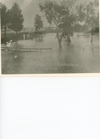
... Floods ...Black and white photograph showing Mitchell River in flood at the old highway bridge at east end of town. Roof of Imperial Hotel in background at far end of bridge, trees and fences under water in foreground. Bairnsdale Victoriabridges, flooding -
Tatura Irrigation & Wartime Camps Museum
Photograph, 1955 flooding, 1955
Sacred Heart Primary School, Tatura, surrounded by flood waters, 1955. School later demolished.Black and white photograph of flooding, Sacred Heart Primary School, Tatura, 1955.on back: Sacred Heart Primary School, Tatura. Flood. 1955. -
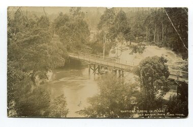 Orbost & District Historical Society
black and white photograph / postcard, Early 20th century - pre 1906?
This photograph shows the Hospital Creek in flood. This is a pictorial record of a bridge in East Gippsland in the early 20th century.A black / white photograph / postcard of a road bridge across a flooded creek. It is in a bush setting.in front at bottom - "Hospital Creek in flood H.D.Bulmer photo Lake Tyers"bridge-hospital-creek tostaree-bridge -
 University of Melbourne, Burnley Campus Archives
Photograph - Black and white print, Orchard in Flood, 1934
... floods ...Black and white photograph. Orchard in flood: shows fruit trees standing in water.On reverse, "Orchard Yarra River in flood Dec 1934."orchard, yarra river, floods, 1934, fruit trees -
Clunes Museum
Ephemera - DVD, IMAGES OF CLUNES FLOOD 2010
... floods ....1 CD photographs of the Clunes floods 4/9/2010 .2 CD Casehandwritten on inside of case: Clunes floods 4/9/2010. Lyndsey Iles, Lathlain Streetfloods, compact disk -
 Ringwood and District Historical Society
Photograph, Looking to Adelaide St. from Reynolds Ave. Ringwood (across Mullum Creek) 1973. Site of bridge washed away in floods 1931. Infant Welfare Centre (Dr. Hewitts) on right
... Mullum Creek) 1973. Site of bridge washed away in floods 1931 ...Black and white photographCatalogue card reads, "Looking to Adelaide St. from Reynolds Ave. (across Mullum Creek) 1973. Site of bridge washed away in floods 1931. Infant Welfare Centre (Dr. Hewitts) on right." -
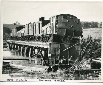 Orbost & District Historical Society
black and white photograph, February 1971
The 1971 flood was the the worst flood on record. At Jarrahmond it was at least 11 metres and up to one and a half kilometres wide on the flats causing enormous damage to the flood plain. Records say that "The brown floodwater stain in Bass Strait could be seen from passing airliners." Considerable damage was done to railway infrastructure, roads and farms. More information from the APRIL, 2008 newsletter by John Phillips. (see orbosthistory.com.au) The railway line was destroyed and was not expected to be opened for a fortnight. Orbost was cut off by 50 square miles of Snowy River floodwater. This train was being shunted across the viaduct when waters smashed through washing away several trucks sending the crew running for their lives.This is pictorial evidence of a significant local event. It is connected to the history of the railway in East Gippsland.A large black / white photograph of flooded railway yards with a train engine stranded on a small section of track surrounded by water and debris.on front - "1971 Flood, Railway Yards"floods-1971-orbost orbost-railway natural-disasters-orbost -
 Greensborough Historical Society
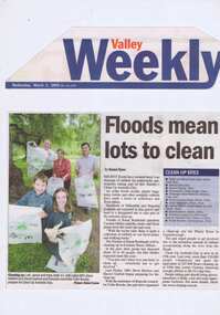
Newspaper Clipping - Digital Image, Barak Bushland Reserve - Floods mean a lot to clean, 02/03/2005
... Barak Bushland Reserve - Floods mean a lot to clean ...Receding flood water levels have revealed much rubbish. Clean Up Australia day volunteers work throughout Banyule and Nillumbik to collect the rubbish.Newspaper clipping, black and white text and colour image.clean up australia day, plenty river -
 University of Melbourne, Burnley Campus Archives
Photograph - Black and white print, Orchard After Flood, 1934
... floods ...Orchard after flood: shows soil washed away from roots around fruit treeOn reverse, "Orchard after flood Dec 1934."orchard, yarra river, floods, 1934, fruit tree, damage to roots -
 Kew Historical Society Inc
Photograph - Flooded street, 1940-50
... floods ...View of unknown flooded streetscape.Original, black and white positive of a flooded street, originally believed to have been in Kew, but based on an examination of the history, deemed not to be a location in Kew or Kew East. The flooding is of a T-intersection with a brick church and a house in the background.Inscribed verso: "? Kew / R 774 / VELOX"floods