Showing 44 items
matching gellibrand hill
-
 Eltham District Historical Society Inc
Photograph, Autumn Excursion, Hume and Hovell's 1824 expedition, 26 May 1996, 26/05/1996
... right at Beveridge. In Gellibrand Hill Park, near the headwaters... right at Beveridge. In Gellibrand Hill Park, near the headwaters ...[article by Bettina Woodburn in EDHS Newsletter No. 109, July 1996:] ON THE TRAIL OF HUME AND HOVELL - REPORT ON THE AUTUMN EXCURSION - On a green and fresh morning (Sunday 26th May 1996) the Cobb and Co coach (driven by the most obliging Peter Tampion) set off in a north easterly direction from Eltham to connect with Hume and Hovell's route on their 1824 explorations of central Victoria. The Society would follow a series of monuments erected for the 1924 centenary of the expedition from King Parrot Creek (Tuesday 7th December 1824), through Strath Creek, over Sunday Creek (Sunday 12th December 1824) at Broadford, Tullamarine, St Albans, Deer Park, through Werribee, skirting east of the You Yangs to Lara and Avalon Beach. Because their distance-measuring wheel had broken and a one degree mistake was made in calculations, the two leaders of the original group of six convict-companions arrived at Corio Bay, instead of the expected Western Port, discovered earlier by Flinders. From below Mt. Disappointment (Hume and Hovell's difficulties in "scrambling over brush and rock", "leeches in forest, as well as no water", "cutting grass 4-5 ft. high", dreadful scrub", "devil flies") we took an easier route, saw the Strath Creek memorial in ground fog and a wonderful "field of dreams", the Hume-Hovell privately owned cricket ground with its white picket boundary fence. Now, after a steep climb, in sunshine under gums we stretched and viewed magnificent rolling hills and fog-filled valleys - not "smoke from Aborigines' bush fires". After morning tea at Broadford we followed the Sunday Creek valley beside the Hume Freeway, passed the Wallan Wallan Rest Area (more appropriately Hume and Hovell Rest Area) to tum right at Beveridge. In Gellibrand Hill Park, near the headwaters of the Moonee Ponds Creek, we experienced the landscape the first European settlers saw - huge river red gums and rolling pastures. The gardens and sheltered courtyard of the 1840s, timber, brought from .....[?] prefabricated Woodlands Homestead, provided a pleasant lunch stop. We enjoyed a private tour, panoramic views over Melbourne and surroundings and the excitement of arriving and departing aircraft. Our next river crossing was at Werribee, "in a vast treeless plain", then we drove on by-ways no coach had previously travelled, to find "an immense sheet of water" salty Corio Bay, off-course to the west. In late afternoon of a super, calm, late autumn day we headed homewards. Back at Eltham we were rather surprised to find that we had travelled a total of 347 km. Thanks again to Russell Yeoman for his research and organization. What a wonderful day! Colour photographactivities, hume and hovell -
 Eltham District Historical Society Inc
Folder, Pioneers & Painters; Shire of Eltham Historical Society research notes, background information, etc, 1969-1986, 1969-1986
Material pertaining to the production of a history of the Shire of Eltham, "Pioneers & Painters: One Hundred Years of Eltham and its Shire" in recognition of the shire's centenary in 1971 Item Title Caption 04768-1 Newspaper clipping - The Eltham of 1905; Gellibrand our first white visitor? Diamond Valley News, 24 June 1969, p5 04768-2 Newspaper clipping - The Eltham of 1905; Gellibrand our first white visitor? Heidelberger, 25 June 1969 04768-3 Notes on Eltham District Road Board Members 1866-1871 04768-4 Notes on Eltham District Road Board Members 1866-1871 04768-5 Map showing Gellibrand's likely route through district 12-13 February 1836 and Hoddles's route of Febrary 1838 04768-6 Notes by Shire Secretary, M.B. Watson regarding meeting with Reverend Longfield regarding history of St Margaret's Church 04768-7 Alan Marshall's notes from discussion with Mr. F. Barrett regarding SEPP images 611, 635 and 636 SEPP_0611 SEPP_0635 SEPP_0636 04768-8 Transcripts of letter from local residents to Charles Joseph Latrobe requesting a bridge over the Plenty River dated 10 April 1849 and his reply dated 5 May 1849; from Latrobe Library Archives - Land Branch Records 04768-9 Notes on history of Eltham Shire, Centenary events and publication of Pioneers & Painters for release in conjunction of opening of new Library 04768-10 Newspaper clipping - Glossy record of shire's romantic past and the people who made it by Fab Calafuri, Diamond Valley News, Tuesday, December 16, 1986, p18 SEPP_0755-3 Letter: Acknowledgement from Colin J. Bock, Eltham Shire Secretary to A.R. Thomas of Bendigo for copy of 1913 photograph of Shire of Eltham Councilors, 21 May 1973 A.R. Thomas' father Mr. A.G. Thomas, C.E., was the Shire Secretary at the time in 1913. Cross Ref: SEPP_0755 The idea to develop a book on the history of the Shire of Eltham to be edited by noted author, Alan Marshall in celebration of the shire's centenary was initiated in 1969. The Shire of Eltham Historical Society undertook significant research in conjunction with Alan Marshall locating material at various institutions and other societies; interviewing longer term residents and a public campaign through the local press to acquire photographic material for duplication and use in the book. The public campaign received generous response and the material collected became the genesis for the Shire of Eltham Pioneers Photograph collection now held in partnership between Eltham District Historical Society and Yarra Plenty Regional Library (Eltham Library).Paper documents of various sizes and newspaper clippingsa.g. thomas, a.r. thomas, alan marshall, bridge road, charles joseph latrobe, council members, d.w. lachlan, eltham district road board, eltham shire council, ernie orford, f. barrett, francis rogerson, g. bransprone, james donaldson, james johnston, john bell, john thomson, joseph tice gellibrand, lower plenty bridge, m.b. watson, main road, map, patrick turnbull, peter morris, pioneers and painters, post office, rev. longfield, sepp, shire of eltham pioneers photograph collection, shire secretary, st margaret's church, thomas armstrong, thomas bell, thomas sweeney, william bell (1796-1870), centenary celebrations, christmas hills, clifton pugh, david newbury, dudley street, eltham, gareth jones roberts, hurstbridge, john perceval, joy peck, kangaroo ground, kinglake, lower plenty, luther haley general store, montmorency, neil douglas, panton hill, peter glass, research (vic.), sheila ferguson, shire of eltham, st andrews, yarra glen -
 Flagstaff Hill Maritime Museum and Village
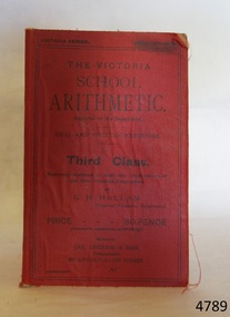
Book, The Victoria School Arithmetic
... Flagstaff Hill Maritime Museum and Village 89 Merri Street ...Sadie Gibson owner SS Gellibrand The Victoria School Arithmetic Author: G H Hallam Publisher: Jas Ingram & Son Date: 1911 flagstaff hill, warrnambool, shipwrecked-coast, flagstaff-hill, flagstaff-hill-maritime-museum, maritime-museum, shipwreck-coast, flagstaff-hill-maritime-village, book, the victoria school arithmetic -
 Koorie Heritage Trust
Book, Batman, John (See Victoriana series), The Settlement at Port Phillip, 1835, 1983
John Batman was born in New South Wales in 1801. With his brother, Henry, he moved to Van Diemen's Land in 1821. In 1824, John received a grant of 600 acres near Ben Lomond and in 1828 he married Eliza Thompson. Batman, with his friend J.H. Wedge and J.T. Gellibrand, determined on an expedition into New Holland. Motivated by Hume and Hovell's discoveries they applied for a grant of land at Western Port. This was refused, but in 1834 the ideas of the Port Phillip Association was discussed...56 p. : 1 folded map. ; 21 cm.John Batman was born in New South Wales in 1801. With his brother, Henry, he moved to Van Diemen's Land in 1821. In 1824, John received a grant of 600 acres near Ben Lomond and in 1828 he married Eliza Thompson. Batman, with his friend J.H. Wedge and J.T. Gellibrand, determined on an expedition into New Holland. Motivated by Hume and Hovell's discoveries they applied for a grant of land at Western Port. This was refused, but in 1834 the ideas of the Port Phillip Association was discussed...batman, john, 1801-1839. | victoria. settlement, 1835. batman, john, 1801-1839. correspondence, diaries, etc.. | pioneers -- victoria -- correspondence. | victoria -- history -- 1834-1851 -- sources. -
 Ballarat Heritage Services
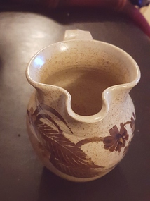
Ceramic - Artwork - Ceramics, Pottery Jug by Gellibrand Pottery
Jon and Alda Hubbard were operating Gellibrand Pottery around the late 1980s on the Old Beech Forrest Road in Gellibrand near Colac in the Otway region.Photo of a hand thrown jug with glaze decoration. It is stamped (impressed) "Gellibrand Pottery". ceramics, pottery, gellibrand pottery, studio pottery -
 Otway Districts Historical Society
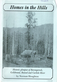
Book, Norman Houghton, Homes in the Hill; Norman Houghton, 2006
Homes in the Hills. Historic glimpses of Barongarook, Gellibrand, Banool and Carlisle River. Norman Houghton. Soft cover. iv, 48 p.; illus, map, diagram. Artwork and layout: Desktop Dymanics. otway ranges; norman houghton; barongarook; gellibrand; banool; carlisle river; agriculture; mining; sport; homes; hills; -
 Otway Districts Historical Society
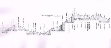
Photograph, Gradient Diagram, Colac to Crowes
Gradient diagram. Colac to Beech Forest to Crowes. 2'6" gauge.colac; tulloh; coram; barongarook; water tanks; birnam; karwarren; hitt's siding; lovat; gellibrand; banool; wimba; mcdevitt; dinmont; devitt bros' siding; ditchley; beech forest; buchanan; ferguson; weeaproinah; pettitt bros' siding; j & m knott siding; kincaid siding; wyelangta; pettitt's siding; stalker; macknott; laver's hill; crowes; gradient; -
 Otway Districts Historical Society
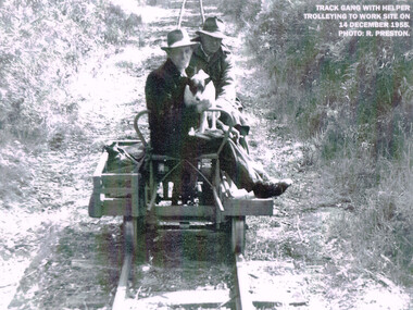
Photograph, R. Preston, Trolleying to work site, 1955, 14 December 1955
At its peak the Beech Forest railway employed more than 21 staff between Colac and Crowes. Gangers (men in charge of the track gangs) tended to be promoted into the Otways but many of their subordinate repairers were local recruits. A few of the men who worked in the original construction gangs of 1900-1902 remained and obtained positions in the track gangs along the line. The track was maintained by seven three-man gangs based at Colac, Barongarook, Gellibrand, Banool, Beech Forest (2), and Lavers Hill. However, track gangs lessened as the line shortened. After 1954, the sole surviving track gang, in charge of Paddy Balcombe, stayed until the line closed.A railway track gang, with helper, trolleying to a work site, on 14 December, 1955.beech forest; railways; track gang; -
 Otway Districts Historical Society
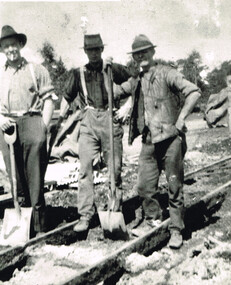
Photograph, Barongarook track gang, c.1925, c.1925
At its peak the Beech Forest railway employed more than 21 people between Colac and Crowes tending the line the trains ran over. The gangers (the men in charge of the track gangs) tended to be promoted into the Otways but many of their subordinate repairers were local recruits. A few of the men who worked on the original construction gangs of 1900-1902 remained and obtained positions in the track gangs along the line. The track was maintained by seven three-man gangs based at Colac, Barongarook, Gellibrand, Banool, Beech Forest (2), and Lavers Hill. The ganger for Beech Forest 2 gang resided at Wyelangta. However, the track gangs lessened as the line shortened. Three men with spades on the line, thought to be at Barongarook, c.1925. B/W.barongarook; railways; track gangs; -
 Otway Districts Historical Society
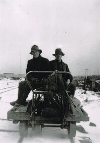
Photograph, Woosnan, Frank, Track gang at Beech Forest, c.1940, c.1940
At its peak the Colac-Beech Forest-Crowes railway employed more than 21 staff tending the lines that the trains ran over. Gangers (the men in charge of the track gangs) tended to be promoted into the Otways but many of their subordinate repairers were local recruits. A few of the men who worked on the original construction gangs of 1900-02 remained and obtained positions in the track gangs along the line, but these eased out over time. The track was maintained by seven three-man gangs based at Colac, Barongarook, Gellibrand, Banool, Beech Forest (where the second Beech Forest crew was based at Wyelangta), and Lavers Hill.Track gang on an NK wagon at Beech Forest, c.1940. Snow covers the ground. B/W.colac; beech forest; crowes; railway; track gangs; -
Otway Districts Historical Society
Trophy, Otway Football Association, Premiers, 1938, Lavers Hill Imperials, c.1938
In 1938, the Otway Football Association initially comprised Beech Forest, Gellibrand, Wyelangta and Carlisle, but altered when Wyelangta and Johanna amalgamated to form Hill Imperials in May, 1938. In the grand final, Hill Imperials and Carlisle met, with Hill imperials emerging victors 13-4, 82 points, to Carlisle 7-15, 57 points, to become 1938 Premiers.Two-handled urn-shaped cup with knobbed lid. Square bakelite base added later.Otway Football; Association, Lavers Hill Imperials. Premiers 1938otway; football; lavers hill imperials; carlisle; -
 Flagstaff Hill Maritime Museum and Village
Photograph - Vessel, Steam tug "Racer", circa 1920's
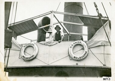
The ocean Steamtug "Racer" was built in 1886 in Sunderland by "Boolds, Sharer and Company" for the "Queenstown Tug and Shipping Company". It is mentioned in several newspapers that soon afterwards it sank in Queenstown Harbour, Ireland and remained submerged for six months before being raised. It was a steel screw boat with a sluice keel, was 185 tons and 420 feet long. It was purchased around 1889 by the "Melbourne Coal, Shipping and Engineering Company Ltd" as it had sufficient power to work with the huge iron clippers that the company were dealing with. It survived several dangerous incidents on its voyage out to Melbourne. On May 28th in the middle of the night in a heavy gale, the tug was swamped by heavy seas and then several hours later was almost run down by a very large ship (the clipper Loch Vennachar) in full sail. The "Racer" (later owned by the "Melbourne Steamship Company") became one of the fastest and best-known tugs in the Port of Melbourne - working in the port until 1935. The "Racer" was involved in many rescues and dangerous incidents during its 45 years including the attempted rescue of the "Craigburn" near Cape Schanck, the rescue of the "Edina" from a reef near Williamstown and the rescue of the "Netherby" from heavy seas near Inverloch. In March 1930 she was caught by a strong wind when turning in the Yarra River and crashed into the Spencer Street Bridge - resulting in some damage to the scaffolding on the bridge and slight damage to the tug. In 1906 the "Racer" created a record for the fastest tow when it towed the 900-ton barque "Elizabeth Graham" from Sydney to Melbourne in 73 hours. In 1934 it was withdrawn from commission with plans for it to be broken up for scrap metal but was bought by a Melbourne businessman to be converted into a three masted schooner trading between Tasmania and Melbourne. George (Joe) Cunningham was born in 1892 in Geelong. His father, Alexander Cunningham was a ship builder and carpenter. George worked on oceangoing ships as a young man but after his marriage, had a twenty-six year career on Tugboats. He worked as a deckhand on the "Racer" and then worked his way up as a mate and then master on the "Maitland" and "Tooronga". Later he was in charge of two larger boats - the "Alvina" and "Helen Moore" and was engaged in salvaging the Union Steamship vessel "Karkariki" near Gellibrand Pile Light at the entrance to Hobsons Bay. George Cunningham died in 1978. This photograph was one of ten photographs donated to Flagstaff Hill Maritime Museum and Village by Fred Trewartha. Frederick John Fox Trewartha (Fred) was a well-known Warrnambool businessman. He was born in Beeac near Geelong in 1920 and came to Warrnambool with his family as a very young child. He was apprenticed to his father John, as a saddler and later opened his own shop on Raglan Parade. He then moved into working with tarpaulins and canvases for the trucking industry. Fred was keenly interested in photography (and was a member of the Warrnambool Cine Club), yachting and boat building. He kept his yacht moored at Port Fairy for many years and participated in sailing events locally and interstate. He also built boats with his sons. He had the opportunity to meet many older sailors and it's thought this photo (and others in the set) may have been given to him by one of these men. Fred Trewartha died in 2016 in Warrnambool.This item is significant as a reminder of the important role tugboats and their crews played in the maritime history of Melbourne and the surrounding seas. This is a close-up view of a tugboat showing a man leaning against the upper deck. Two lifebuoys (with the words S. S. Racer Melbourne) are attached to the side of the deck and a funnel and an airvent are in the background. A handwritten note in pencil saying "Geo Cunningham on board Racer "is on the back of the photograph.Back - "Geo Cunningham on board Racer" Front (on lifebuoys) - S. S. RACER MELBOURNEflagstaff hill maritime museum and village, great ocean road, tugboats, steamtug boats, racer, george cunningham, port of melbourne, melbourne steamship company, rescues, craigburn, steamtug, edina, elizabeth graham, netherby, yarra river, ships, historic maritime photographs, boolds sharer and company, queenstown tug and shipping company, melbourne coal shipping and engineering company limited