Showing 49 items matching "glen valley road"
-
 Eltham District Historical Society Inc
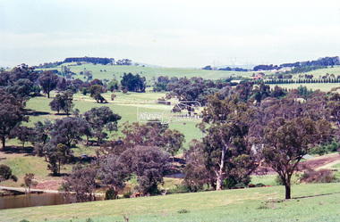
Negative - Photograph, Looking northeast from Eltham-Yarra Glen Road towards the Eltham War Memorial Tower, Kangaroo Ground, 1998c
On November 11th 1926 the Shire of Eltham War Memorial Tower at Kangaroo Ground was opened. It is regarded as one of Melbourne’s most outstanding lookout towers. It commands a magnificent 360 degree panorama from Kinglake across the Diamond Valley to Macedon and the You Yangs. It is built on a peak which was once a volcano, 237 metres above sea level. After World War one a memorial cairn was erected on the site, and in 1925 a committee of public-minded citizens began to plan for a tower. Many generous donations of material and money were forthcoming so that in 1926 the Governor General Lord Stonehaven was able to unveil the plaque before a crowd of 500 people There was some concern in the 1960s when the Forests Commission wanted to build a firespotters cabin on the top. At first R.S.L. branches opposed the idea, but it was realised that this use could combine with its use as a tourist attraction, and would ensure its maintenance for the future. Today the Kangaroo Ground tower provides one of the best views around Melbourne and is a fitting memorial to those who died in two world wars. From: Historic items for Diamond Valley Community Radio September 1990 (EDHS collection) On November 8th, 1951, the memorial was re-dedicated by the Governor of Victoria, Sir Dallas Brooks with the addition of the names of men from the Shire of Eltham who fell in the Second World War. Further wreaths were added subsequent to this image in time for the 2001 Reembrance Day service to commemorate the men from th shire who had fallen in the Malayan, Korean, Borneo and Vietnam campaigns.Roll of 35mm colour negative film, 8 strips and associated 10 x 15 cm colour printKodak Gold 100-5eltham-yarra glen road, garden hill, kangaroo ground, memorial park, shire of eltham war memorial tower, war memorial tower -
 Eltham District Historical Society Inc
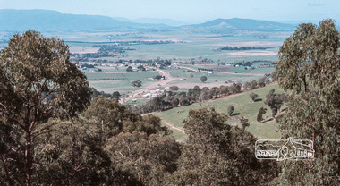
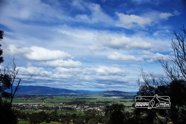
Photograph, Fred Mitchell, Yarra Glen Valley from lookout on Skyline Road, Yarra Glen, 1968, 1968
Digital copy of colour photographfred mitchell collection, 1968, skyline road, yarra glen -
 Eltham District Historical Society Inc
Photograph, Fred Mitchell, Yarra Glen Valley from lookout on Skyline Road, Yarra Glen, 1968, 1968
Digital copy of colour photographfred mitchell collection, 1968, skyline road, yarra glen -
 Eltham District Historical Society Inc
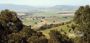
Photograph, View from Breakneck, Yarra Glen, 27 August 2016, 27/08/2016
"Until 1865, all wheeled traffic to the Upper Yarra District passed through Christmas Hills along present day Ridge and Muir roads, then followed the hazardous course of "The Breakneck" (now Breakneck Road) to the valley below. To slow the descent of wagons, logs are said to have been dragged behind. In 1865, an easier route was opened on the south side of the Yarra River, and led to the birth of Lilydale". - Christmas Hills Past and Present (Yarra Glen District Historical Society), 2004.Digital copy of colour photographfred mitchell collection, 2016, breakneck, yarra glen -
 Eltham District Historical Society Inc
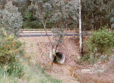
Photograph, Valley Road Culvert, Wattle Glen, c. Oct 1987, 1987
... Valley Road Culvert, Wattle Glen, c. Oct 1987... infrastructure shire of eltham Valley Road Culvert Wattle Glen Colour ...Date based on other similar display panels visible in images of the Shire of Eltham display at the Eltham Community Festival, 7 November 1987.Colour photographdisplay panel, eltham festival, infrastructure, shire of eltham, valley road, culvert, wattle glen -
 Coal Creek Community Park & Museum
Tin, tea
... Korumburra gippsland Glen Valley Tea Cylindrical metal container ...Cylindrical metal container with push on lid, green background colour with pictures of flowers and text on sides.Glen Valley Tea -
 Monbulk RSL Sub Branch
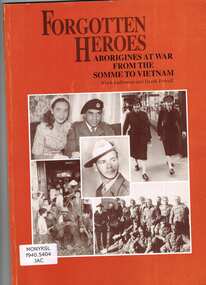
Book, Alick Jackomos et al, Forgotten heroes : Aborigines at war from the Somme to Vietnam, 1993
The involvement of Victorian and New South Wales Aboriginal people in war; World War One; World War Two; Korea; Vietnam; James Lovett; Hannah Lovett; Reg Rawlings; Henry Thorpe; John Firebrace; Dan Cooper; Jackson Stewart; Reg Saunders; Harry Saunders; George Birkett; Bill Egan; Jack Kennedy; Linda (Lester) Nihill; Marge Tucker; Alice Lovett; Connie Alberts; Stewart Murray; Norman Herbert Franklin; Bill Edwards; Lester Marks Harradine; Clarke family; Merv Bundle; Leo Maxwell Muir; Glen James; Graham Atkinson; Pat Owen; Cummeragunga; Lake Tyers; Framlingham; list of Aboriginal servicemen and women; different treatment of Aboriginal people during the war and after; introduction by Terry Garwood annotated separately.Ill, p.88.The involvement of Victorian and New South Wales Aboriginal people in war; World War One; World War Two; Korea; Vietnam; James Lovett; Hannah Lovett; Reg Rawlings; Henry Thorpe; John Firebrace; Dan Cooper; Jackson Stewart; Reg Saunders; Harry Saunders; George Birkett; Bill Egan; Jack Kennedy; Linda (Lester) Nihill; Marge Tucker; Alice Lovett; Connie Alberts; Stewart Murray; Norman Herbert Franklin; Bill Edwards; Lester Marks Harradine; Clarke family; Merv Bundle; Leo Maxwell Muir; Glen James; Graham Atkinson; Pat Owen; Cummeragunga; Lake Tyers; Framlingham; list of Aboriginal servicemen and women; different treatment of Aboriginal people during the war and after; introduction by Terry Garwood annotated separately.australia - military forces - aboriginal members, australia - aboriginals - personal histories - military -
Whitehorse Historical Society Inc.
Newspaper - Article, Williams Road, Blackburn, 21/07/1976
... Mitcham melbourne Williams Road Blackburn Glen Valley Park ...Article re purchase by Nunawading Council of land for public open space in Nunawading Gazette 21 July 1976.williams road, blackburn, glen valley park, cootamundra walk, parks and reserves, city of nunawading -
 Southern Sherbrooke Historical Society Inc.
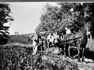
Photograph - Adults and children with a horse and cart in Belgrave South, c.1940s
Black and white photo showing three adults and two children with a horse and cart. Mr Archibald William Muirhead, of 7 Colby Drive, Belgrave Heights (then called Glen Rd) stands to the left of the cart with his left hand resting on the wheel and his right hand on his hip. His left leg is crossed in front of his right leg. He is wearing a light-coloured suit. Sitting in the cart are two women and a boy and a girl. The girl is Pam Harris. They are on a dirt road with trees on either side. Behind them is a cleared area with more trees in the background. The photo was taken on Glen Road close to Monbulk Creek. On the back of the photo is printed '1627'. It probably dates to the 1940s and is part of a collection of family photos donated by Pam Harris, Shire of Sherbrooke President, 1982-1983 & 1987-1988. -
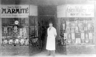 Surrey Hills Historical Society Collection
Photograph, Edward Blanchford Wright's grocery shop, Canterbury Road, Surrey Hills
Edward Blatchford Wright was born in 1894 in Birmingham, son of Edward Wright and Florence Emuss. It is not known when he migrated to Australia but he served in the AIF during WW1, seeing action in France. On enlistment aged 20 years 9 months, he gave his occupation as farmer. He married Gertrude Matilda Wain in 1919. He came to Surrey Hills c1924. He was a grocer in the area for several decades with shops in Canterbury Road. In 1942 he is listed at 235 Union Road. This was a residential address. Alan Holt's Surrey Hills property register places him at 365 Canterbury Road (c1920-1930) and 359 Canterbury Road (c1930-1940). He died in 1972 in Mont Albert. His last electoral roll entry in 1968 gives 18 Serpentine Street, Mont Albert. He and his wife are buried in Burwood Cemetery.Black and white photo of the exterior of Edward Blanchford Wright's grocery shop in Canterbury Road, Surrey Hills. The screen door is open and William Reynolds stands in the opening, dressed in a long white coat. The window displays are stacked high with cans and packages and large signs advertising the prices of goods. There is advertising on the windows for Marmite, Glen Valley tea, Preservene soap and Brockoff's biscuits. advertising, shops, grocers, businesses, union road shops, edward blatchford wright, william reynolds, burwood cemetery, world war 1, canterbury road -
 Wodonga & District Historical Society Inc
Book - Ghost Towns of the High Country, Luke Steenhuis, 1998
Stories and information about former towns in and around Victoria's Alpine Region. Towns include Boggy Creek, Brandy Creek, Brocket, Brookville, Buckland, Buckland Upper, Bulgoback, Bulltown, Hogtown, Bullumwaal, Canvastown, Cassilis, Cobbannah, Copenhagen, Dargo High Plains, Dartmouth, Deptford, Gibbo River, Gladstone, Glen Dart, Glen Valley, Glen Wills, Good Luck Creek, Granite Flat, Grant, Hinnomunjie, Howittville, Jeff Davis, Lightning Creek, Louisville, Mayford, Merrijig Creek, Mitchelldale, Mount Elmo, Nugong, Sassafras, Saltpetre, Staleyville, Stirling, Store Creek, Summer Hill, Sunnyside, Tabberabbera, Talbotville, Thiel Town, Tongio West, Waterford, Wentworth River, Winchester, Wombat, Wongungarra, Zulu Creek.non-fictionStories and information about former towns in and around Victoria's Alpine Region. Towns include Boggy Creek, Brandy Creek, Brocket, Brookville, Buckland, Buckland Upper, Bulgoback, Bulltown, Hogtown, Bullumwaal, Canvastown, Cassilis, Cobbannah, Copenhagen, Dargo High Plains, Dartmouth, Deptford, Gibbo River, Gladstone, Glen Dart, Glen Valley, Glen Wills, Good Luck Creek, Granite Flat, Grant, Hinnomunjie, Howittville, Jeff Davis, Lightning Creek, Louisville, Mayford, Merrijig Creek, Mitchelldale, Mount Elmo, Nugong, Sassafras, Saltpetre, Staleyville, Stirling, Store Creek, Summer Hill, Sunnyside, Tabberabbera, Talbotville, Thiel Town, Tongio West, Waterford, Wentworth River, Winchester, Wombat, Wongungarra, Zulu Creek.ghost towns, high country victoria, pioneers, history victoria -
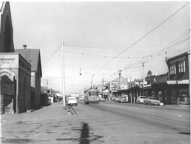 Melbourne Tram Museum
Photograph - Footscray - Victoria St - tram 678, Jim Seletto, c1960
The photograph shows MMTB X2 class tram No 678, southbound in Victoria St Footscray/Seddon on its way to Williamstown Road terminus at the corner with Walter St. On the left side is the Victoria St Methodist church. On the right is a shopping centre with signs for The Sun, The Herald, Keily, Solite floor, and Glen Valley tea. See item 8215 for a photo of X1 in the same street.Yields information about the trams in Victoria St Footscray / Seddon c1960.Black and White photograph with photographer's notes on rear"J Seletto photo"trams, x2 class, tram 678, victoria st, footscray -
 Eltham District Historical Society Inc
Photograph - Digital Photograph, Marguerite Marshall, Strathewen Public Hall, 20 August 2008
Strathewen Public Hall, social and spiritual centre was later lost in the Black Saturday fires 2009. The Strathewen Community decided a community hall was needed in 1901. In 1902 locals built the hall with messmate trees. It was located on the Cottlesbridge-Strathewen Road. The first function was a Grand concert and Balll attended by about 120 people. Several denominations held Church services and Sunday School services in the Hall. It survived several bushfires until after this photo was taken when it was destroyed in Black Saturday, 9 February 2009. Published: Nillumbik Now and Then / Marguerite Marshall 2008; photographs Alan King with Marguerite Marshall.; p89 Strathewen was settled late, largely because it was difficult to access.1 Early selectors found it a struggle to survive. They had to do everything themselves, from felling trees for buildings, to taking produce to market along bush tracks that they had helped cut. Small dairy farms were typical but fruit became the district’s prime produce. The first settlers east of Arthurs Creek were brothers John and Duncan Smith whose station Glen-Ard was probably operated as a sheep run. Other early settlers were the Mann family, who were to donate land for the hall, provide postal services and John Mann was an Eltham Shire councillor from 1916 to 1919.2 In 1873 James Mann, his wife Jane and their six children, settled on 207 acres (83.7) (Lang Fauld Farm) on both sides of Eagles Nest Road, from the foot of Mount Sugarloaf to the bank of the Arthurs Creek. In 1883 James took up another selection on Chads Creek. It was very hard work and at times he was well behind with his rent. However the family had a good social life, attending the Primitive Methodist Church at the Arthurs Creek Township and on New Year’s Eve throwing a party for all the locals. By 1874 James Mann’s younger brother, John, selected 311 acres (125.8ha) between Eagles Nest Road and upper Arthurs Creek. He called it Carseburn after his home parish in Scotland. Tragically in 1875 John drowned in the Yarra River, at Richmond.3 John Mann’s oldest son, also John, later purchased Duncan Smith’s land, which he named Violet Glen. He was to give one acre (0.4ha) of this land for the Strathewen Hall site. A Mann family diary written at Carseburn in 1897, tells how the district’s name was selected. Strathewen is derived from ‘strath’ meaning ‘broad mountain valley’ and from the name of Ewen H. Cameron, the local parliamentarian for almost 40 years. ‘George Brain came around to get a petition signed to get a post office up here and we had to vote for a name—Strathewen, Glen-Ard, or Headcorie’.4 It was at Carseburn that a public meeting in 1901, decided to build the Strathewen Hall on the Cottlesbridge-Strathewen Road. In 1902 the locals built the hall with messmate trees. The first function was a Grand Concert and Ball attended by around 120 people and several Protestant denominations took turns to hold church services and Sunday School there. Fortunately the hall has survived bushfires to be the town’s spiritual and social centre.5 The area continued to develop and in 1909 a post office operated somewhere at Strathewen and from around 1916 at Carseburn.6 It was not until 1914 that land was bought to establish the Strathewen State School on School Ridge Road. The residents paid £100 to build it on two acres (0.8 ha) while the Education Department contributed £30 and leased the building annually for £1. When teacher Miss Mary Golding opened the school in 1917, it had no equipment.7 But in 1921 the Education Department provided desks and a hexagonal shelter shed (now a rare style in Victoria) and took control in 1925.8 By 1917 Strathewen was booming.9 George Apted had built a coolstore in 1916, and local orchardists bought storage space until the 1950s. This allowed the area to supply the market in and out of season. Guesthouses catered for growing tourism. In the mid 1920s Mrs Eleanor Sparkes built the guest-house Singing Waters, which operated through the 1930s. Her daughter Mrs Vera McKimmie, ran it until the 1950s and the house remains in Chads Creek Road. In the Great Depression land was cleared for timber to be sold as firewood and there was small scale sawmilling. However the orchard industry diminished for several reasons including the 1939 bushfires and rapid changes in production methods. Today the Apteds still operate an orchard and farm at Glen-Ard, which straddles the border between Strathewen and Arthurs Creek. It includes the southern part of Duncan Smith’s original Glen-Ard selection.This collection of almost 130 photos about places and people within the Shire of Nillumbik, an urban and rural municipality in Melbourne's north, contributes to an understanding of the history of the Shire. Published in 2008 immediately prior to the Black Saturday bushfires of February 7, 2009, it documents sites that were impacted, and in some cases destroyed by the fires. It includes photographs taken especially for the publication, creating a unique time capsule representing the Shire in the early 21st century. It remains the most recent comprehenesive publication devoted to the Shire's history connecting local residents to the past. nillumbik now and then (marshall-king) collection, strathewan public hall -
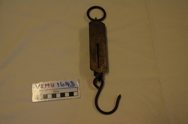 Emerald Museum & Nobelius Heritage Park
Orchadist Scales, Donated by Frank Eckerman (Emerald)
Used in orchards by Harry Shaw (Orchardist in Springvale Rd, Glen Waverley near cnr Highbury Road) Orchard was sold in 1950. Later used on poultry farm in Forest Hills.Body of scales: brass plate inscribed - Salter Pocket Balance, made in England. No.3. To weigh 50LB. Slide measure 0 to 50. Pattern at top: twisted rope with arrow through middle. Reverse side: green painted metal. Hanging metal ring at top end and metal hook at lower end. Salter Pocket Balance, Made in England. No.3. To weigh 50LB. -
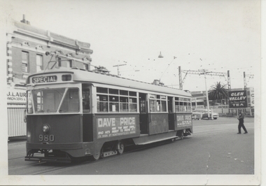 Melbourne Tram Museum
Photograph - Black & White Photograph/s, Chris Phillips, Feb. 1969
Black and white photograph of PCC 980 at Caulfield Station area, during a special tram tour, 9/2/1969. Photo by Chris Phillips. Glen Valley Tea advert in background. Has a Dave Price advertisement on the side of the tram. ARE Tour ex South Melbourne depot. Road name to be advised. Printed on Kodak Paper.In red ink "PCC 980 Caulfield Stn 9/2/69"trams, tramways, mmtb, special trams, caulfield, tram 980, pcc class -
 Eltham District Historical Society Inc
Albert Jones, 'Golden Glen', home of photographer, Albert Jones
At the right of the photo is an apple orchard over the other side of Watery Gully creek. The house at the far end and middle building in the photo remain as of 2024, located at 205 Kangaroo Ground-Wattle Glen Rd, Kangaroo Ground between Pretty Hill Lane and Millers Road. https://maps.app.goo.gl/riyy56LsfEMz4w5W6 Reproduced in The Diamond Valley Story, Dianne H Edwards, The Shire of Diamond Valley 1979, p138 "Golden Glen, the home at Wattle Glen of photographer and orchardist Albert Jones. It was in one of these outbuildings that the hundreds of glass negatives of the Spark/Jones Collection werer found. Phot: Spark/Jones Collection" See Ref: EDHS_03112 A WINDOW ON THE PAST by Roger Sanders, The Sun, Wednesday, Auguist 11, 1976, pp 38-39 A fascinating window has been opened on the early life of the Eltham district. It is a rare collection of 3,000 perfectly preserved glass plate photograph negatives. The collection is the work of the late Albert Jones, a Diamond Creek orchardist and amateur photographer. About 500 of the negatives have been printed and 100 are on display at Gallery 4, Eltham, as part of the Eltham Festival," which started on Friday. They capture in fine detail rural and village life around Eltham, Hurstbridge, Kangaroo Ground, Yarra Glen and Diamond Valley from 1900 to 1930. While the natural beauty of the district was painted in this period by Arthur Streeton (later Sir Arthur), Tom Roberts and Charles Conder, among others, photography was relatively new. Yet Albert Jones used the new medium to compile a weighty album of pioneers at work, at home, at sport and on holidays. He was at the first Yarra Glen race meeting, early Diamond Valley football matches and photographed soldiers from the district leaving for war. He photographed early gold mines, men with horses laying the Diamond Creek-Hurstbridge rail track and the arrival of the first steam train at Hurstbridge. He took his cameras on holiday around Victoria and the collection includes scenes from St. Kilda and Portsea and many country towns. The Jones collection of negatives was found by Mr A. J. "Ned" Spark, of Balwyn, under a house he bought from Mr Jones' widow. The plates almost went to the tip with a pile of rubbish before Mr Spark realised their potential value. Mr Spark, who is retired, will continue the identification and recording of the photographs when he returns from holidays. The exhibition of the Jones' photographs is open each afternoon until August 21 at Gallery 4, 1016 Main Rd., Eltham. Photographs included in article: • The priceless collection of glass plate negatives were found under this house in Eltham [actually Wattle Glen], home of Albert Jones and his wife. • A quiet country pub - Panton Hills Hotel. • Teams of draught horses were used in the building of the Diamond Creek-Hursbridge railway in 1910. • Chinaman Jimmy using a gold cradle in Wattle Glen Gully. • The photographer and orchardist Albert Jones. His work is on show as part of the Eltham Festival • St Kilda Pier – several of the houses are still standing, but the waterfront has changed dramatically since this was taken before 1920. • A picnic was a dressy affair at the start of the century – the women in this family group are decked in lace and pearls.Stamped in purple ink on reverse within border "A.J. SPARK COLLECTION PHOTOS 1900 - 1930 PHOTOGHRAPHER LATE ALBERT JONES DIAMOND VALLEY. TEL: 83-3561"a.j. spark collection, albert jones, golden glen, shops, wattle glen -
Eltham District Historical Society Inc
Document - Folder, Smith, Samuel
Samuel Smith came to Australia about 1849 with his wife and family, settling at Queenstown and, with the gold rush, established an abattoir. A descendant, Marjorie Smith Motschall wrote about the family in 'Wild WoodDays at Panton Hill'. Many descendants have lived in and around Eltham. The family had four generations of butchers, including Keith, who had a shop in Kew. Contents Photocopy of handwritten notes: Samuel Smith biography. Typed version of handwritten notes: Samuel Smith biography. Letter L Adam to Eltham Shire, 6 March 1884. Seeking information about the Smith family in Yarra Glen: Samuel Smith and Eliza Hurst. Photocopy of page from magazine National Trust Australia (Vic), no date (possibly 1993). Keith Smith closed his butcher shop, Kew, and donated equipment to National Trust, possibly to go to Gulf Station. Newspaper article: "Smith family's fortunes yielded to modern technology - in 1850", Diamond Valley News, 10 March 1987. Newspaper clippings, A4 photocopies, etcsamuel smith, eliza hurst, keith smith, gulf station yarra glen, james smith, queenstown, st andrews, sarah smith, richard smith, mary smith, edwin smith, thomas smith, john smith, ralph smith, marjorie smith motshall, wild wood days at panton hill book, louisa purcell, st andrews church queenstown, cherry tree road panton hill, beaumont house panton hill, edwin james samuel smith, violet bartlett, ethel may smith, mary louise smith, violet smtih, fred smith, alan smith, cemetery smiths gully road st andrews, russell smith, joan smith, joyce smith, ethel smith, grand hotel yarra glen -
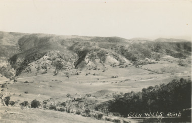 Lakes Entrance Historical Society
Postcard - Glen Wills Victoria, 1940 c
For over 20 years from 1893 gold mining was undertaken in the mountains around Glen Wills.Black and white postcard looking towards the Glen Wills Road situated between the valley and steep hills taken in summer Glen Wills Victoriasettlement, topography