Showing 474 items matching "gold industry"
-
 The Beechworth Burke Museum
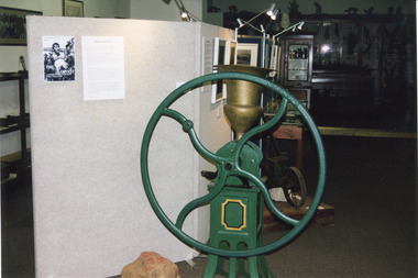
Photograph, Estimate 1999
This photograph was taken in 1999 at 'The Harvest' exhibition at the Burke Museum for members of Baking Industry Victoria. The grain mill, manufactured by B.M. Purshouse in Wolverhampton, England, was of special interest.This photograph is of primary social significance to the Beechworth community because it depicts a 19th-century grain mill, manufactured by B.M. Purshouse in Wolverhampton, England, which was probably used at flour mills in the Ovens District, such as that at Tarrawingee, which opened in 1866. The purchase of agricultural machinery such as the grain mill accompanied the expansion of agriculture, including grain growing, in the Ovens District following the gold mining prosperity of the 1850s. This photograph may be of interest to researchers who wish to observe an image of the Purshouse grain mill.Colour rectangular photograph printed on matte AGFA photographic paper.Obverse: THE HARVEST / THE HARVEST Reverse: 2854beechworth, burke museum, promoting settlement, living in country towns, making regional centres, preserving traditions and commemorating, farming and agriculture, exhibitions, burke museum exhibitions, building local economies, transforming land, victorian agricultural history, marketing and promoting agricultural products, the harvest exhibition, harvests, victorian gold rush towns, grain mill, bm purshouse, crops and grain, baking industry victoria -
 The Beechworth Burke Museum
Photograph, c1990
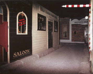
Taken in the 1990's, this photograph depicts a row of shop fronts in the 'Street of Shops' exhibition in the Burke Museum in Beechworth. This exhibition was created and opened in 1979 and was intended to reflect and imitate a historic peirod in the town's past. The time period decpicted is that of the Gold Rush which swept through many Victorian towns from the 1850's onwards. For the town of Beechworth, the gold rush began in 1852, when gold was discovered in Spring Creek, drawing in many new residents seeking to make a fortune and transforming a once remote town into a bustling centre brimming with hope and opportunity. By 1857, the town contained over 200,000 residents and with this, the need for more amenities and intsitutions arose. Multiple churches, banks, schools, shops, hospitals and other essential buildings appearing over the years. The wealth acquired through the gold rush is largely responsible for the vast development of the town and many of its significant buildings which still remain to this day. This photograph also highlights the significance of this type of exhibition, providing a new mode of experiencing and learning about the past. The street depicts the many supporting trades and industries that arose from the mass migration during the gold rush. The creation of the Street of Shops in 1979 was envisioned by Roy Harvey who was the curator at the time, with the intention of recreating an authentic feel to the environment while collecting from the community to accurately portray the multiculturalism that is ingrainded in many towns and communities of Victoria. This photograph contains historical significance as it relates to and portrays an especially important period of time within Beechworth and Victoria's history. The gold rush phenomena ushered in a wave of hope and prosperity for citizens and immigrants alike. It provided many with the opportunity to strike it rich, while the town prospered and grew in many ways. This widespread development that accompanied the gold rush occured throughout Victoria and holds great historical importance when recording the social, economic and communal developments that occured throughout the time period which gave way to the beloved towns and communities we know today. Beechworth itself is acknowledged as Victoria's best-preserved gold mining town and deserves recognition of its significance. it also showcases the great significance of social develpment and globalization that occured throughout the state during this period. Coloured rectangular photograph printed on matte photographic paper and unmounted. Obverse: Dancing every night 8pm-6am [mirror] / Gold Diggers Arms Hotel façade / Star / Beechworth Gold / J. Davidson / Saloon Reverse: 3306 beechworth, burke museum, street of shops, gold rush, indigo shire gold rush, 1850s beechworth, burke museum exhibitions, saloon, gold buyer, hotel, historical streetscape, gold rush immigration -
 The Beechworth Burke Museum
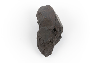
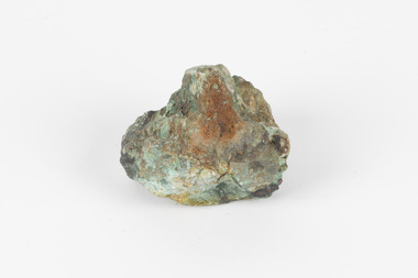
Geological specimen - Brown coal
This particular specimen was recovered from the Lal Lal Coal and Iron Mine in Victoria, 19km from Ballarat. Brown Coal was discovered here in 1857, just alongside the Geelong to Ballarat Railway line. This discovery of lignite (brown coal) was the first in Victoria, which would bring important benefits to the region and state, both of which had previously been reliant on coal imports. In the 1860s, iron ore was found just 5km from Lal Lal, and the area was converted into an Iron Ore Mine. The Lal Lal Iron Mining Company took over operations in 1874, who then peaked iron production in 1884. This mine continued operations until June 1884, when the blast furnace was extinguished and never recommenced. The blast furnace at Lal Lal is considered one of the most important and highly significant sites ion early industrial history in Australia, as it is the only remaining best furnace from the nineteenth century in the Southern Hemisphere. The furnace ruins are 17 metres high, and are clearly visible today on Iron Mine Road, Lal Lal, near the Bungal Dam. This specimen of Lignite (brown coal) is significant, as it was mined from the area where brown coal was first discovered in Victoria, leading to an important and controversial future of the mining and use of brown coal in this State. The Victorian Heritage Database has listed the Lal Lal Coal Mine with local significance, with their Statement of Significance stating: "The Lal Lal coal mine is historically significant as the site of the first discovery of lignite (brown coal) in Victoria, and one that promised important benefits to regional and state industries that were reliant on coal imports at the time. The significance of the stie is reduced by the poor state of preservation of the coal mining and processing fabric". This specimen is part of a larger collection of geological and mineral specimens collected from around Australia (and some parts of the world) and donated to the Burke Museum between 1868-1880. A large percentage of these specimens were collected in Victoria as part of the Geological Survey of Victoria that begun in 1852 (in response to the Gold Rush) to study and map the geology of Victoria. Collecting geological specimens was an important part of mapping and understanding the scientific makeup of the earth. Many of these specimens were sent to research and collecting organisations across Australia, including the Burke Museum, to educate and encourage further study.A hand-sized light-weight, soft and combustable sedimentary rock specimen, that is dark brown in colour. The specimen has jagged edges, as though parts of the rock have crumbled away. Brown coal, or Lignite, is formed naturally from compressed peat, and is typically found in natural basins. The stages to the formation of coal ('coalification') begin with plant material and wood, which will decay if it is not subjected to deep burial or heating, and turn into Peat. Peat, when sufficiently compressed naturally, will turn into Brown Coal (Lignite), and finally into Black Coal (sub-bituminous, bituminous and anthracite). Each successive stage has a higher energy content and lower water content. It is brownish-black in colour. Brown Coal has a high moisture content, between 50 and 75 percent, and a low carbon content. Some Brown Coals may be stratified, with layers of plant matter, which means little coalification has occurred beyond the peat natural processing stage. When Brown Coal is submerged in dilute nitric acid or boiling potassium hydroxide solution, it reacts to produce a reddish solution, of which higher-ranked coals do not. When brown coal is pulverised and burned in boilers, the steam is used to drive turbines, which generates electricity. It is the lowest rank of coal, as when burned, it creates a relatively low heat content, which in turn does not create a great output of steam. burke museum, beechworth, indigo shire, beechworth museum, geological, geological specimen, mineralogy, brown coal, brown coal specimen, lignite, lal lal, lal lal coal mine, lal lal iron mine, ballarat, blast furnace -
 The Beechworth Burke Museum
Audio - Oral History, Jennifer Williams, Mr Tom Carey, 3/08/2000
Mr Tom Carey was born in 1940 in Beechworth to family from Beechworth and Woolshed. His family had strong associations with Australia's Gold Rush, with grandparents having followed the rush from town to town, and parents in Beechworth. Tom has strong associations with Beechworth and its surrounds, with his family having some connection to the Kelly Gang. Tom worked in many industries in Beechworth, from the Bridge Road, Price’s Store, tannery, post office, the Kiewa Murray Water Authority, and the Beechworth Council. This oral history recording was part of a project conducted by Jennifer Williams in the year 2000 to capture the everyday life and struggles in Beechworth during the twentieth century. This project involved recording seventy oral histories on cassette tapes of local Beechworth residents which were then published in a book titled: Listen to what they say: voices of twentieth century Beechworth. These cassette tapes were digitised in July 2021 with funds made available by the Friends of the Burke. Mr Tom Carey account of his life in Beechworth and the local area during the 20th century is historically and socially significant to the cultural heritage of the region. He details important historical events and hardships in the region's history that had a lasting local, regional and national impact, including Australia during war time, economic struggles, and women's and men’s societal roles in a rural area. This oral history account is socially and historically significant as it is a part of a broader collection of interviews conducted by Jennifer Williams which were published in the book 'Listen to what they say: voices of twentieth-century Beechworth.' While the township of Beechworth is known for its history as a gold rush town, these accounts provide a unique insight into the day-to-day life of the town's residents during the 20th century, many of which will have now been lost if they had not been preserved. This is a digital copy of a recording that was originally captured on a cassette tape. The cassette tape is black with a horizontal white strip and is currently stored in a clear flat plastic rectangular container. It holds up 40 minutes of recordings on each sideMr Tom Carey/ beechworth, oral history, burke museum, tannery, beechworth council, kelly gang, bridge road, price’s store, post office, the kiewa murray water authority, woolshed, gold rush, carey, tom carey, listen to what they say -
The Beechworth Burke Museum
Audio - Oral History, Jennifer Williams, Mr Allan Parkinson, 22nd June 2000
Allan Parkinson was born in Beechworth in 1924. The eldest of eight children, his mother provided laundry services to the people of Beechworth whilst his father worked for the local tannery, trapping rabbits. Allan fondly remembers times spent during his childhood catching rabbits with his father. As his younger years were set amidst the experiences of World War Two and the Great Depression, Allan recalls a feeling of solidarity amongst the residents of Beechworth that was present during this time(for instance, sharing food with neighbours in wartime), as well as the disassociation he felt as a returning soldier after the war. Allan talks of the great number of 'New Australians' who arrived in Beechworth in the post-war years, many of them coming from war-torn countries in Europe. Before being integrated into Australian society, these 'New Australians' would often first spend time at the Migrant Reception and Training Centre in Bonegilla, Northern Victoria. They were taught English and learnt about Australian life before being billeted out across the country to fill labor shortages. Following time spent up in Queensland, Allan worked in the forestry industry, clearing thousands of acres across Victoria which were needed to plant pines. The interview ends with discussions of the famous Wheelbarrow Push from Beechworth to Mt Buffalo in 1935, of which Allan's Uncle Tom was a central participant; this is an event which has since become an annual fundraising tradition in Beechworth. This oral history recording was part of a project conducted by Jennifer Williams in the year 2000 to capture the everyday life and struggles in Beechworth during the twentieth century. This project involved recording seventy oral histories on cassette tapes of local Beechworth residents which were then published in a book titled: Listen to what they say: Voices of twentieth century Beechworth. These cassette tapes were digitised in July 2021 with funds made available by the Friends of the Burke. Mr Allan Parkinson's account of his life in Beechworth and the local area during the twentieth century is historically and socially significant to the cultural heritage of the region. He details important historical events and hardships that had lasting local, regional and national impacts, including Australia during wartime, post-war migration and economic struggles. This oral history account is historically and socially significant as it is part of a broader collection of interviews conducted by Jennifer Williams which were published in the book 'Listen to what they say: voices of twentieth century Beechworth'. While the township of Beechworth is known for its history as a gold rush town, these accounts provide a unique insight into the day-to-day life of the town's residents during the twentieth century, many of which would have been lost if they had not been preserved. This is a digital copy of a recording that was originally captured on a cassette tape. The cassette tape is black with a horizontal white stripe and is currently stored in a clear flat plastic rectangular container. It holds up to forty minutes of recordings on each side. Mr Allan Parkinson / allan parkinson, oral history, beechworth forestry, forestry industry, beechworth tannery, jennifer williams, rabbit trapping, new australians, australian depression, rabbiting, bonegilla, bonegilla migrant camp, 20th century beechworth, wheelbarrow push beechworth to mt buffalo, barrowthon, wheelbarrow push 1935, listen to what they say, listen to what they say: voices of twentieth century beechworth, world war two, wartime, wartime solidarity, burke museum -
 The Beechworth Burke Museum
Audio - Oral History, Jennifer Williams, Hubert Warner, 2 April 2000
Hubert Warner’s story shows insight to the families that emigrated from Europe for the gold rush. It illustrates the nuances of life in the district. This history speaks of land cultivation and the innovation of industry in the region, in particular sheep and cattle farming and slaughter. Warner speaks of the highs and lows of the practice of breeding cattle, the awards he won, but also the hardships that come with working on the land such as having to face natural disaster. This oral history recording was part of a project conducted by Jennifer Williams in the year 2000 to capture the everyday life and struggles in Beechworth during the twentieth century. This project involved recording seventy oral histories on cassette tapes of local Beechworth residents which were then published in a book titles: Listen to what they say: voices of twentieth century Beechworth. These cassette tapes were digitised in July 2021 with funds made available by the Friends of the Burke.Hubert Warner's account of life in Beechworth is uniquely illustrative as it captures many aspects of the community. It explains the motivation for European migrants for choosing to settle in the area and how they were able to both become a part of and create a presence in their local community. This oral history also exemplifies the process of developing industry through the twentieth century, how it was done, the struggles it faces, and the triumphs that came with this. Warner's history is specific to the cattle industry and shows great nuance in the day-to-day operation of such a business over time. This is a digital copy of a recording that was originally captured on a cassette tape. The cassette tape is black with a horizontal white strip and is currently stored in a clear flat plastic rectangular container. It holds up 40 minutes of recordings on each side. Herbert Warnerlisten to what they say, listen to what they say: voices of twentieth century beechworth, 1800s beechworth, 20th century beechworth, beechworth, farming and agriculture, cattle, gold, gold rush, farm, farming -
 The Beechworth Burke Museum
Audio - Oral History, Jennifer Williams, Barry Pope, 26/6/2000
Barry Pope left Melbourne at the intentions of travelling around Australia, met a local girl in Beechworth and decided to stay. He worked firstly in logging operations at the mill in Stanley, had some bartending jobs at Beechworth hotels, then got a job as a kitchen-hand at the Mayday Hill Hospital. Taking up new opportunities to advance his career and earning potential, he trained as a prison officer, working for several months at Pentridge Prison and Fairlea Women's Prison in Melbourne. He then returned to Beechworth to work in the prison system. In his story Mr Pope discusses many aspects of prison life for both prisoners and prison officers, from the food and daily routine, attitudes to discipline and rehabilitation, industries and opportunities available to prisoners and how prisoners were viewed in society after their period in prison was finished. This oral history recording was part of a project conducted by Jennifer Williams in the year 2000 to capture the everyday life and struggles in Beechworth during the twentieth century. This project involved recording seventy oral histories on cassette tapes of local Beechworth residents which were then published in a book titled: Listen to what they say: voices of twentieth century Beechworth. These cassette tapes were digitised in July 2021 with funds made available by the Friends of the Burke.Barry Pope's account of his career is historically and socially significant as it details practices within the prison industry in the Twentieth Century as well as the operations of regional hospitals. This oral history account is socially and historically significant as it is a part of a broader collection of interviews conducted by Jennifer Williams which were published in the book 'Listen to what they say: voices of twentieth-century Beechworth.' While the township of Beechworth is known for its history as a gold rush town, these accounts provide a unique insight into the day-to-day life of the town's residents during the 20th century, many of which will have now been lost if they had not been preserved.This is a digital copy of a recording that was originally captured on a cassette tape. The cassette tape is black with a horizontal white strip and is currently stored in a clear flat plastic rectangular container. It holds up 40 minutes of recordings on each side.Barry Pope /beechworth, 1960s, 1970s, 1980s, stanley mill, logging, hotel wentworth, oral history, hospital garden, mayday hill hospital, met hospital, social welfare department, loyola, lyolla, pentridge prison, fairlea women's prison, prison officer training, drug crimes, prison daily life, prison farm, prison wood workshop, prison industry, prison escapes, beechworth prison, prison suicides, prison violence, prisoner attitudes to crime, mental health, isolation cells, walking dog scheme, guide dogs, prison concerts, prison plays, george smee, prison food, prison officer accommodation -
The Beechworth Burke Museum
Audio - Oral History, Jennifer Williams, Mrs Vanessa McDonald, 9 November 2000
Mrs. Vanessa McDonald was born in Beechworth in 1917. Christened, Agnes Bertha Collins, Vanessa changed her name in 1960. Mrs. McDonald's family's connection with gold mining in the district reach back to the first of Beechworth's gold rushes, when her great grandfather, a Dutchman who adopted the name Charles Collins, arrived in 1851-1852. Mrs. McDonald spent her childhood in the isolated hamlet of Stanley, in the area known as 'Little Scotland', where she recalls helping her mother to raise younger siblings, picking apples and walnuts on the family farm, and roaming the hills for wildflowers. As a young woman Mrs. McDonald attended religious and social gatherings in the local community. In 1940 she went to Melbourne to work as a mothercraft nurse during the Second World War. She met her husband at a Beechworth football match and was married at the Stanley Methodist Church in 1941. The gold diggings known as the 'Nine Mile' became the hamlet of Stanley, after the British Prime Minister, Lord Stanley, in 1858. By the late 1850s, Stanley boasted schools, an athenaeum, a church, a weekly newspaper and several hotels and other civic infrastructure to cater for a growing population. The area attracted large numbers of Chinese miners, whose presence was frequently resisted. Like other early Victorian mining settlements, Stanley was a hotbed of political and racial tensions during the gold rush. One side of the Nine Mile Creek was known as 'Little Scotland’, the other, 'Little Ireland'. A number of Christian denominations built congregations and churches in Stanley, including the Church of England, Methodist Church, the Catholic Church, and Presbyterian Church. Stanley became part of the United Shire of Beechworth in 1871. By 1880 timber was being cut and two sawmills were established by 1887. River-dredged gold mining consumed vast amounts of timber from the forests in the area, and in 1931 the first of several softwood plantations began. This oral history recording was part of a project conducted by Jennifer Williams in the year 2000 to capture the everyday life and struggles in Beechworth during the twentieth century. This project involved recording seventy oral histories on cassette tapes of local Beechworth residents which were then published in a book titled: 'Listen to what they say: voices of twentieth century Beechworth'. These cassette tapes were digitised in July 2021 with funds made available by the Friends of the Burke.Following the decline in the mining and associated industries during the early-mid-twentieth century, the Beechworth district experienced a period of general economic decline. On the east side of the Dingle Range, Mrs. McDonald's father, William Henry Collins, felled timber and the family were pioneer apple orchardists. The establishment of apple orchards in Stanley reflects changes to how land was used and contributes to our understanding of the historical development of rural communities following the gold rush. Mrs. McDonald's recollections are significant for understanding family and social life in a small rural town in years leading up to the Great Depression and prior to the Second World War. This oral history recording may be compared with other oral histories and items in the Burke Museum's collection. This oral history account is socially and historically significant as it is a part of a broader collection of interviews conducted by Jennifer Williams which were published in the book 'Listen to what they say: voices of twentieth-century Beechworth.' While the township of Beechworth is known for its history as a gold rush town, these accounts provide a unique insight into the day-to-day life of the town's residents during the 20th century, many of which will have now been lost if they had not been preserved.This is a digital copy of a recording that was originally captured on a cassette tape. The cassette tape is black with a horizontal white strip and is currently stored in a clear flat plastic rectangular container. It holds up 40 minutes of recordings on each side.Mrs Vanessa McDonald /listen to what they say, beechworth, oral history, burke museum, emigration, gold rush immigration, victorian gold rush, mining families, apple orchard, forestry, forest plantation, little scotland, stanley, twentieth century history, regional australia, rural australia, farming, harvest festival, great depression, dingle range, the nine mile, australian wildflowers, high country wildflowers, mothercraft nurse, rural and regional women, social history, collins, mrs. vanessa mcdonald, building community life, shaping cultural and creative life, fruit growers, family history, changes to land use in regional victoria -
 The Beechworth Burke Museum
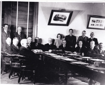
Photograph, Unknown c.1900s
This image depicts a group of local counsellors from the Shire of Beechworth (est. mid to late 1900s). The identities of those within the photo remain unknown. The table and chairs featured in the image were produced in the late 19th century and have been in continual use for more than 100 years. The councellors would likely have convened in the Beechworth Town Hall. A History of Beechworth: Gold was discovered in the May Day Hills district in 1852. A canvas and timber settlement soon developed as prospectors rushed to the area. Over four million ounces of gold was recovered in the first 14 years. Between 1852 and 1857, Beechworth was a gold-producing region and centre of government, boasting many industries and a multicultural population. Beechworth was proclaimed a borough on the 11th of September 1863, a formalisation of the municipal incorporation of the town seven years before. This image is associated with the history of Beechworth; it reveals the identities of local counsellors, persons whose contribution to the Beechworth Shire could otherwise be lost to time. Black and white rectangular photograph, unmounted.beechworth council, indigo shire, local victorian government -
 The Beechworth Burke Museum
Photograph
The photograph depicts two young men standing atop a prominent outcrop at Lake Sambell, with buildings visible on the further shore. The present day park and reserve occupies the site of the former Rocky Mountain Mining Company, an open-cut sluice mine that began operations in the mid-Nineteenth Century and operated until the early 1900s, through the peak of Victoria’s Gold Rush. It was converted into a park and leisure area in the 1920s. Lake Sambell was formally opened to the public on Friday 5th October 1928 and was opened by the Victorian Government’s Minister of Lands, Mr Bailey, as part of initiatives to boost the economies and development of country towns. The lake was named after Mr L.H. Sambell, a shire engineer and secretary of the Forward Beechworth Committee who was involved in promoting the transformation of the mining site and promoting plantation forestry and tourism as alternative industries. £300 to begin the process was provided by Mr J. McConvill, a former resident of Beechworth, who is remembered in a street name adjacent to the lake. An article in the Ovens and Murray Advertiser on Saturday, 5th May, 1917, gives some insight into issues in the Rocky Mountain Mining Company’s final years. The writer details the 1917 annual meeting of the Rocky Mountain Mining Company, stating that locals present appeared ‘well pleased this important local industry is in such a prosperous condition and that future prospects are so encouraging’. The author describes plans to give workers a bonus as evidence of profit-sharing that would ‘bridge the gulf between capital and labour’. The article concludes, however, with the statement that ‘there is a little arithmetical puzzle in the report in connection with the dredging operations I have been unable to solve.' The photograph is significant as it contributes to knowledge about how Beechworth reinvented itself after the Gold rush period, and more broadly how country towns repurpose and redevelop infrastructure and facilities to meet the present needs of their population. Sepia rectangular photograph printed on matte photographic paper. Obverse: nil. Reverse: 3471 / Velox (paper mark)beechworth, beechworth lake, lake sambell, l.h. sambell, mcconvill, rocky mountain mining company, rocky mountain mining co, minister of lands, forward beechworth committee, wallace park-lake sambell development scheme, wallace park lake sambell development scheme, lake, sambell, j. mcconvill, recreation, reserve, park, transformation, repurposed, redeveloped -
 The Beechworth Burke Museum
Photograph, c1960
The photograph depicts a view across the water at Lake Sambell. The image dates from approximately 1960. The present day park and reserve occupies the site of the former Rocky Mountain Mining Company, an open-cut sluice mine that began operations in the mid-Nineteenth Century and operated until the early 1900s, through the peak of Victoria’s Gold Rush. It was converted into a park and leisure area in the 1920s. Lake Sambell was formally opened to the public on Friday 5th October 1928 and was opened by the Victorian Government’s Minister of Lands, Mr Bailey, as part of initiatives to boost the economies and development of country towns. The lake was named after Mr L.H. Sambell, a shire engineer and secretary of the Forward Beechworth Committee who was involved in promoting the transformation of the mining site and promoting plantation forestry and tourism as alternative industries. £300 to begin the process was provided by Mr J. McConvill, a former resident of Beechworth, who is remembered in a street name adjacent to the lake. Residents of Beechworth have worked to raise funds to improve the Lake Sambell reserve several times, such as efforts in the 1930s and 1940s to raise the banks several feet to deepen the water for swimming purposes. Fundraising campaigns include the ‘Ugly Man’ competition conducted on behalf of the Wallace Park-Lake Sambell Development Scheme. The latter competition was run by the Fire Brigade Bend’s team as part of a larger competition called the ‘Mile of Pennies’; it was won by Mr Len Knight of Beechworth’s Commercial Hotel. The ‘Mile of Pennies’ was conducted at a Carnival held on New Year’s Eve, 1947. It was proposed by the Beechworth and District Progress Association. As well as improving swimming facilities, funds were raised to install a caravan park facility near the lake. Funds were also donated by commercial entities, such as £250 received from Zwar Bros. Pty Ltd. The photograph is significant as it shows the level of development of Beechworth in the early to mid-Twentieth Century. Sepia rectangular photograph printed on matte photographic paperObverse: nil. Reverse: 3470 / Velox (paper mark)beechworth, beechworth lake, lake sambell, lake, beechworth and district progress association, forward beechworth committee, ugly man, mile of pennies, wallace park lake sambell development scheme, wallace park-lake sambell development scheme, zwar bros, zwar, l.h. sambell, j. mcconvill, minister of lands, commercial hotel, len knight, rocky mountain mining company, rocky mountain mining co, gold rush, redevelopment, transformation, community fundraising -
 The Beechworth Burke Museum
Photograph, c1960
The photograph depicts a view across the water at Lake Sambell. The image is thought to date from the 1960s so may show the lake during a period of drought, such as that experienced across South-Eastern Australia in 1967. The present day park and reserve occupies the site of the former Rocky Mountain Mining Company, an open-cut sluice mine that began operations in the mid-Nineteenth Century and operated until the early 1900s, through the peak of Victoria’s Gold Rush. It was converted into a park and leisure area in the 1920s. Lake Sambell was formally opened to the public on Friday 5th October 1928 and was opened by the Victorian Government’s Minister of Lands, Mr Bailey, as part of initiatives to boost the economies and development of country towns. The lake was named after Mr L.H. Sambell, a shire engineer and secretary of the Forward Beechworth Committee who was involved in promoting the transformation of the mining site and promoting plantation forestry and tourism as alternative industries. £300 to begin the process was provided by Mr J. McConvill, a former resident of Beechworth, who is remembered in a street name adjacent to the lake. Residents of Beechworth have worked to raise funds to improve the Lake Sambell reserve several times, such as efforts in the 1930s and 1940s to raise the banks several feet to deepen the water for swimming purposes. Fundraising campaigns include the ‘Ugly Man’ competition conducted on behalf of the Wallace Park-Lake Sambell Development Scheme. The latter competition was run by the Fire Brigade Bend’s team as part of a larger competition called the ‘Mile of Pennies’; it was won by Mr Len Knight of Beechworth’s Commercial Hotel. The ‘Mile of Pennies’ was conducted at a Carnival held on New Year’s Eve, 1947. It was proposed by the Beechworth and District Progress Association. As well as improving swimming facilities, funds were raised to install a caravan park facility near the lake. Funds were also donated by commercial entities, such as £250 received from Zwar Bros. Pty Ltd.The photograph is significant as it shows Lake Sambell at lower water levels, such as may have been experienced during period of drought.Sepia rectangular photograph printed on matte photographic paperObverse: nil Reverse: 3470beechworth, beechworth lake, lake sambell, lake, beechworth and district progress association, forward beechworth committee, ugly man, mile of pennies, wallace park lake sambell development scheme, wallace park-lake sambell development scheme, zwar bros, zwar, l.h. sambell, j. mcconvill, minister of lands, commercial hotel, len knight, rocky mountain mining company, rocky mountain mining co, gold rush, redevelopment, transformation, community fundraising, drought, 1967, 1960s -
 The Beechworth Burke Museum
Photograph, c1960
The photographs in this set depict views across the water at Lake Sambell. The images date from approximately 1960. The present day park and reserve occupies the site of the former Rocky Mountain Mining Company, an open-cut sluice mine that began operations in the mid-19th Century and operated until the early 1900s, through the peak of Victoria’s Gold Rush. It was converted into a park and leisure area in the 1920s. Lake Sambell was formally opened to the public on Friday 5th October 1928 and was opened by the Victorian Government’s Minister of Lands, Mr Bailey, as part of initiatives to boost the economies and development of country towns. The lake was named after Mr L.H. Sambell, a shire engineer and secretary of the Forward Beechworth Committee who was involved in promoting the transformation of the mining site and promoting plantation forestry and tourism as alternative industries. £300 to begin the process was provided by Mr J. McConvill, a former resident of Beechworth, who is remembered in a street name adjacent to the lake. Residents of Beechworth have worked to raise funds to improve the Lake Sambell reserve several times, such as efforts in the 1930s and 1940s to raise the banks several feet to deepen the water for swimming purposes. Fundraising campaigns include the ‘Ugly Man’ competition conducted on behalf of the Wallace Park-Lake Sambell Development Scheme. The latter competition was run by the Fire Brigade Bend’s team as part of a larger competition called the ‘Mile of Pennies’; it was won by Mr Len Knight of Beechworth’s Commercial Hotel. The ‘Mile of Pennies’ was conducted at a Carnival held on New Year’s Eve, 1947. It was proposed by the Beechworth and District Progress Association. As well as improving swimming facilities, funds were raised to install a caravan park facility near the lake. Funds were also donated by commercial entities, such as £250 received from Zwar Bros. Pty Ltd.The photographs are significant as they show the level of development in Beechworth in the middle of the Twentieth Century. Four sepia and black and white rectangular photographs printed on matte photographic paper. 3469.1: Obverse: nil Reverse: 3469-1 3469.2: Obverse: nil Reverse: 3469-2 3469.3: Obverse: nil Reverse: 3469-3 3469.4: Obverse: nil Reverse: 3469-4beechworth, beechworth lake, lake sambell, lake, beechworth and district progress association, forward beechworth committee, ugly man, mile of pennies, wallace park lake sambell development scheme, wallace park-lake sambell development scheme, zwar bros, zwar, l.h. sambell, j. mcconvill, minister of lands, commercial hotel, len knight, rocky mountain mining company, rocky mountain mining co, gold rush, redevelopment, transformation, community fundraising -
 The Beechworth Burke Museum
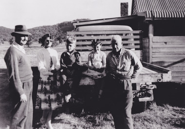
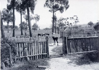
Photograph, circa. 1850
Date not confirmed, a farm in the Beechworth Warner property with a farmer overlooking calves, poultry and timber. This photograph depicts the farming and agriculture industry in Beechworth. The property, known as Daintree Stud or the Warner property, was formed a part of the town on Beechworth, Victoria. Beechworth became famous in the 19th century from a short- lived gold-rush. The town grew to the extent of building a hospital and mental hospital, court house, hotels, convent, and prison. During this time, the industrial growth of Beechworth was significant, seeing a rise in practices including tanning, cobbling, blacksmithing, and the selling of livestock. This photograph perhaps reveals a small degree of insight into the livestock business.Black and white rectangular photograph on matte photographic paper, unmountedReverse: 5896/ BMM 8093-1farm, agriculture, farming and agriculture, beechworth, beechworth farm, industry -
 The Beechworth Burke Museum
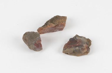
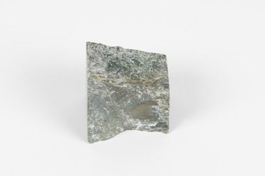
Geological specimen - Unknown, possible Carnelian Agate or Chalcedony
Although it is not known where these specimens were collected, Victoria and other regions of Australia were surveyed for sites of potential mineral wealth throughout the 19th Century. The identification of sites containing valuable commodities such as gold, iron ore and gemstones in a locality had the potential to shape the development and history of communities and industries in the area. The discovery of gold in Victoria, for instance, had a significant influence on the development of the area now known as 'the goldfields', including Beechworth; the city of Melbourne and Victoria as a whole. Agate occurs when amygdales (gas pockets) form in the upper levels of basaltic lava flows. If these pockets or bubbles are iniltrated by water bearing silica in solution, the fluid dries and hardens in layers, forming round or egg shaped nodules or geodes within the rocky matrix. Agate is formed of a silica mineral chalcedony similar to quartz. The term carnelian primarily refers to the reddish shading of the stone; whether the stone is termed an agate or chalcedony type is often influenced by the degree of colour banding the specimen shows. The specimens are significant as examples of surveying activity undertaken to assess and direct the development of the mineral resource industries in Victoria and Australia, as well as the movement to expand human knowledge of earth sciences such as mineralogy and geology in the nineteenth century.Three small geological specimens that appear visually consistent with images of rough or unpolished Carnelian Agate or Chalcedony. geological specimen, geology, geology collection, burke museum, beechworth, indigo shire, north-east victoria, gemstones, agate, carnelian -
 The Beechworth Burke Museum
Geological specimen - Dolomite
Dolomite is a mineral, calcium magnesium carbonate, with the chemical formula CaMg(CO3)2. It is a principle component of various rock types sometimes also referred to as dolomite, including dolostone, dolomitic marble and dolomitic limestone (according to the composition of each type). Dolomite rock is found in sedimentary basins throughout the world, comprising approximately 2% of the Earth's crust. It is formed when lime mud or limestone encounters groundwater containing magnesium. Dolomite can contain elements such as lead, zinc and copper. Dolomite and limestone are used in various construction, landscaping and agricultural processes. This specimen was donated to the Burke Museum in 1868 by Alfred Selwyn as part of the Geological Survey of Victoria. It was donated to the Museum in 1868. Victoria and other regions of Australia were surveyed for sites of potential mineral wealth throughout the 19th Century. The identification of sites containing valuable commodities such as gold, iron ore and gemstones in a locality had the potential to shape the development and history of communities and industries in the area. The discovery of gold in Victoria, for instance, had a significant influence on the development of the area now known as 'the goldfields', including Beechworth; the city of Melbourne and Victoria as a whole. Dolomite and limestone are mined at several locations in Victoria, including sites in the North-East of the state in Bindi and Limestone Creek. There are notable dolomite deposits in most Australian states. The dolomitised form of the mineral tends to come from older limestone deposits, formed during the palaeozoic era in marine settings, so this specimen may have come from a deposit located along a coastline in Victoria or another state. The specimen is significant as an example of surveying activity undertaken to assess and direct the development of the mineral resource industries in Victoria and Australia, as well as the movement to expand human knowledge of earth sciences such as mineralogy and geology in the nineteenth century. This specimen is part of a larger collection of geological and mineral specimens collected from around Australia (and some parts of the world) and donated to the Burke Museum between 1868-1880. A large percentage of these specimens were collected in Victoria as part of the Geological Survey of Victoria that begun in 1852 (in response to the Gold Rush) to study and map the geology of Victoria. Collecting geological specimens was an important part of mapping and understanding the scientific makeup of the earth. Many of these specimens were sent to research and collecting organisations across Australia, including the Burke Museum, to educate and encourage further study.Hand-sized piece of pale pink dolomite (calcium magnesium carbonate) with dark grey rim and hollowed centre. geological specimen, geology, geology collection, burke museum, beechworth, dolomite, mineralogy, geological survey, alfred selwyn, limestone, calcium magnesium carbonate -
 The Beechworth Burke Museum
Geological specimen - Malachite, unknown
Malachite is a water soluble, crystalline, triphenyl methylene chloride salt. It has a close relationship to copper because it is common for Malachite and copper to come from the same ore. Malachite often has shades of green, making it also known as Malachite Green. As a result of it's colour, it is known for being a dye and has been used in the dye industry, the textile industry and in medical fields. Cobar in New South Wales is well known for it's mining. This is because of the number of important deposits present in the area and include three important mining belts where most of the materials are found. These are the 'Cobar belt', the 'Canbelego belt' and the 'Girilambone belt'. The 'Cobar belt' runs underneath the main town. Copper was first discovered in Cobar in 1869 and since then, many deposits of other materials have been found, including Malachite.This specimen is significant because it comes from Cobar, NSW and represents the many deposits of materials found there. Cobar has a long history of mining and is a source of Australia's copper minerals. Malachite is often found in copper deposits meaning that it is representative of Cobar's copper production. Malachite is known for it's vivid green colour and as a result, has many uses, such as meaning used as a dye. This makes it a valuable material and highly significant. This specimen is part of a larger collection of geological and mineral specimens collected from around Australia (and some parts of the world) and donated to the Burke Museum between 1868-1880. A large percentage of these specimens were collected in Victoria as part of the Geological Survey of Victoria that begun in 1852 (in response to the Gold Rush) to study and map the geology of Victoria. Collecting geological specimens was an important part of mapping and understanding the scientific makeup of the earth. Many of these specimens were sent to research and collecting organisations across Australia, including the Burke Museum, to educate and encourage further study.A solid hand-sized mineral with shades of brown , white and light green throughout.geological specimen, geology, geology collection, burke museum, beechworth, malachite, copper, water soluble, cobar, cobar mines, cobar mining, cobar nsw, nsw, new south wales, mining belts, ore, copper ore, malachite green, dye, green, dye industry, textile industry, desposits, canbelego, girilambone, alfred selwyn -
 The Beechworth Burke Museum
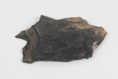
Geological specimen - Oil shale
This particular specimen is found in Wolgan Valley, New South Wales. It could be linked to the abandoned oil shale mining sites in Wolgan Valley such as Newnes. Newnes was an industrial complex operational in the early 20th century is now partly surrounded by Wollemi National Park. It produced motor spirit, kerosene, and gas oil. Newnes's Torbanite oil shale rock contained around 350 litres of oil shale per tonne. The Torbanite was mined by the Commonwealth Oil Corporation Ltd. Oil shale is a sedimentary rock and also a form of fossil fuel. It is often formed millions of years ago and usually contain fossilised remains of plants and/or animals. Oil shale is rich in kerogen that releases hydrocarbon when heated. These hydrocarbon can be used as an alternative petroleum or natural gas. The oil-shale rock was converted into oil by "destructive distillation"; the rock being heated until it broke down to form an oily vapour and an ash residue. Oil bearing shale is one of Australia's national assets. There are many oil companies established in Australia. It reflects Australia's rich natural resources as well as connection to the Australia's engineering and oil industry. The booming oil shale extraction businesses can be traced as far back as 1920s. This specimen is part of a larger collection of geological and mineral specimens collected from around Australia (and some parts of the world) and donated to the Burke Museum between 1868-1880. A large percentage of these specimens were collected in Victoria as part of the Geological Survey of Victoria that begun in 1852 (in response to the Gold Rush) to study and map the geology of Victoria. Collecting geological specimens was an important part of mapping and understanding the scientific makeup of the earth. Many of these specimens were sent to research and collecting organisations across Australia, including the Burke Museum, to educate and encourage further study.Piece of dark gray oil bearing shale with shades of light brown and fossilised leavesExisting label: OIL BEARING SHALE with / FOSSILISED LEAVES / Locality: Wongan Valley, NSW / Donor: Miss M. Cambell geological specimen, geology, geology collection, burke museum, beechworth, oil shale, shale, fossil fuels, alfred selwyn, wolgen valley, 1868 geological survey of victoria, rocks, sedimentary rocks, newnes, torbanite, commonwealth oil corporation ltd -
 The Beechworth Burke Museum
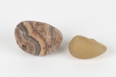
Geological specimen - Agate and Quartz pebbles
Agate occurs when amygdales (gas pockets) form in the upper levels of basaltic lava flows. If these pockets or bubbles are iniltrated by water bearing silica in solution, the fluid dries and hardens in layers, forming round or egg shaped nodules or geodes within the rocky matrix. Agate is formed of a silica mineral chalcedony similar to quartz. Although relatively common and semi-precious, agate has been prized since at least 1450 BC - an intricately carved agate seal was found in the 2015 excavation of a grave belonging to a Mycenaeum priest or warrior near Pylos in Greece. Agate is also used in jewellery and other decorative or ritual purposes due to its often striking appearance. Quartz is found all over Australia, including Beechworth in Victoria. It is formed in deep-seated igneous rocks and crystallized through hot aqueous solutions. It can have two forms; Microcrystalline quartz or Crystalline quartz. Microcrystalline quartz is a fine grain quartz where crystalline quartz is often a large crystal. The colour of quartz can vary. These specimens were collected in Victoria in the vicinity of the Burke Museum. Victoria and other regions of Australia were surveyed for sites of potential mineral wealth throughout the 19th Century. The identification of sites containing valuable commodities such as gold, iron ore and gemstones in a locality had the potential to shape the development and history of communities and industries in the area. The discovery of gold in Victoria, for instance, had a significant influence on the development of the area now known as 'the goldfields', including Beechworth; the city of Melbourne and Victoria as a whole.The specimens are significant as examples of surveying activity undertaken to assess and direct the development of the mineral resource industries in Victoria and Australia, as well as the movement to expand human knowledge of earth sciences such as mineralogy and geology in the nineteenth century.Geological specimens of Agate and Quartz respectively; the fist-sized piece of Agate has peach/coral colouring with grey concentric patterning and the smaller piece of quartz is a uniform yellow/orange shade. Existing label: Local pebbles / (agate and / quartz / (yellowish) / egg-shaped). / BB geological specimen, geology, geology collection, burke museum, beechworth, agate, quartz, north-east victoria, indigo shire, geological surveys -
 The Beechworth Burke Museum
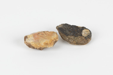
Geological specimen - North Queensland Agates, Unknown
Agate occurs when amygdales (gas pockets) form in the upper levels of basaltic lava flows. If these pockets or bubbles are iniltrated by water bearing silica in solution, the fluid dries and hardens in layers, forming round or egg shaped nodules or geodes within the rocky matrix. Agate is formed of a silica mineral chalcedony similar to quartz. Although relatively common and semi-precious, agate has been prized since at least 1450 BC - an intricately carved agate seal was found in the 2015 excavation of a grave belonging to a Mycenaeum priest or warrior near Pylos in Greece. Agate is also used in jewellery and other decorative or ritual purposes due to its often striking appearance. These specimens originated in North Queensland, which contains noted agate-fossicking regions such as in the area surrounding Forsayth. They were collected in approximately 1852 as an adjunct to the Geological Survey of Victoria. It was donated to the Museum in 1868. Victoria and other regions of Australia were surveyed for sites of potential mineral wealth throughout the 19th Century. The identification of sites containing valuable commodities such as gold, iron ore and gemstones in a locality had the potential to shape the development and history of communities and industries in the area. The discovery of gold in Victoria, for instance, had a significant influence on the development of the area now known as 'the goldfields', including Beechworth; the city of Melbourne and Victoria as a whole. The specimens are significant as examples of surveying activity undertaken to assess and direct the development of the mineral resource industries in Victoria and Australia, as well as the movement to expand human knowledge of earth sciences such as mineralogy and geology in the nineteenth century. Two solid egg-sized pieces of peach/orange toned agate (a common semi-precious chalcedony, similar to quartz) with a striped pattern, embedded in a light and dark brown matrix. geological specimen, geology, geology collection, burke museum, beechworth, agate, north queensland agate, 1852 geological survey of victoria, l. hufer - donor, mineralogy, agate specimen, indigo shire -
 The Beechworth Burke Museum
Geological specimen - Greenstone, Hokitika Jade Company, unknown
New Zealand Greenstone, also called Pounamu is found on New Zealand’s South Island in riverbeds and boulders, and colours vary depending on the source, but always include green tones. It is a form of the mineral nephrite, also known as jade, and is a tough stone with a crystalline structure, made up of calcium magnesium and iron silicate. Its hardness means it is ideal for carving, and has been used for this purpose throughout history, especially by the Maori people of New Zealand. Greenstone features heavily in Maori mythology, and the traditional name for the South Island, Te-Wai-Pounamu, literally translates to waters of greenstone. Wearing of Greenstone pendants with different carvings is practiced by Maori to represent connection to land and ancestors, or to endow the wearer with certain attributes. The sticker on the base of the specimen identifies it as a product of Hokitika Jade Company. The company, which was active in the 1970s, sold jade and greenstone specimens and ornaments. Hokitika, which started life as an 1860s gold rush town, is the origin of most nephrite found in New Zealand, and the centre of the Greenstone carving industry. The object has scientific and research potential as part of the Burke Museum's Geology Collection, and as and example of New Zealand Greenstone. It also has spiritual significance for it's role in Maori beliefs and communities, where it is both traditionally worn and features in mythology. As a valuable stone regularly used in carving and jewellery, it has aesthetic significance. Sticker on base: "N.Z. Greenstone/ a product of/ Hokitika Jade Coy."geological specimen, geology, geology collection, burke museum, beechworth, new zealand, greenstone, hokitika, nephrite, jade -
 Orbost & District Historical Society
record container, From 1902 - 1911
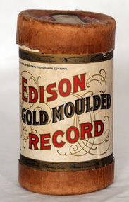
... and was important in the early recording industry. Gold Moulded records ...Phonograph cylinders are the earliest commercial medium for recording and reproducing sound. Commonly known simply as "records" , these hollow cylindrical objects have an audio recording engraved on the outside surface, which can be reproduced when they are played on a mechanical cylinder phonograph. The "Gold-Moulded" process was developed in 1902 and involved creating a metal mould from a wax master; a brown wax blank would be placed inside and heated . as the blank expanded, the grooves would be pressed into the blank which would then be cooled. The "gold" is derived from the traces of that metal used as a conductive agent in the initial mould. "Whistler and his Dog" was performed by the Edison Military Band.Edison Records was one of the earliest record labels which pioneered sound recording and reproduction and was important in the early recording industry. Gold Moulded records used a process that Edison had developed, that allowed a mould to be made from a master cylinder which then permitted the production of several hundred cylinders to be made from the mould. Previously cylinders were recorded live or by hooking two machine together to copy from one cylinder to another, and they used softer brown wax which wore out in as few as twenty playings. Gold Moulded Records were discontinued in 1912.A cardboard cylindrical record container. It is an Edison Gold Moulded Record container. The label has red and gold print and a photo Thomas A. Edison.Hand-written on lid - Whistler & His Dogedison-gold-moulded-cylinders sound-recording records -
 Orbost & District Historical Society
plaque
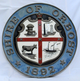
The Coat of Arms of the Shire of Orbost has been designed in the form of a cross in which five stars are set on a shield. This was typical of those used by many shires and cities throughout Victoria and the Commonwealth. A small crown above the cross indicates the loyalty of the President, Councillors and Ratepayers to the reigning King or Queen. The inner circle of the shield contains four figures, a sheaf of wheat, a factory, a cow, and a ship, which represents the activities of agriculture, fishing, industry and dairying undertaken in the district. Originally part of the Bairnsdale district, Orbost split away as part of the Shire of Tambo in 1882, and became a Shire in its own right as the Shire of Croajingolong on the 30th may 1892. The name changed to the Shire of Orbost on 17 February 1893. Orbost was divided into four ridings on 31st May 1895, they were the North, South, East and Central riding, which was represented by three elected councillors. The Shire coat of arms was on the wall on the right of the front entrance to the building and was removed from the current building when Orbost Shire Council was amalgamated into East Gippsland Shire in 1994.The current building was opened on Friday 28th February 1969 by the Premier of Victoria, The Hon. Sir Henry E. Bolte, K.C.M.G., M.P. Local governments play an important role in the lives of citizens in Australia. Local government authorities exist to provide services and amenities to local communities, and are also responsible for regulating and providing services for land and property in their district. This item is representative of a time when Orbost had its own Shire Council. A large round metal plaque with the words SHIRE OF ORBOST1892 in gold letters around a crown and shield divided into four sections to represent four industries : Shipping ; farming - maize ; dairy and mining.SHIRE OF ORBOST 1892government orbost-shire-council coat-of-arms plaque -
 Orbost & District Historical Society
bottle, Probably WW11
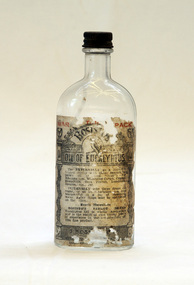
Joseph Bosisto was a Yorkshireman who had qualified as a Pharmacist in Leeds and London. He arrived in Adelaide in 1848 at the age of 21. In 1851 he moved to Victoria in search of gold, but instead opened a pharmacy in Richmond, where he built a laboratory to investigate the chemical and medicinal properties of Australian plants. As a result of the collaboration with von Meuller the essential oil industry of Australia began in 1852, when Bosisto commenced operations in a small, rudely constructed still at Dandenong Creek, Victoria, using the leaves of a form of E. radiata (then known as E. amygdalina) which grew profusely in the district. Bosisto soon built other distilleries at Emerald, Menzies Creek and Macclesfield. World War II soldiers packed it in their mess kits to keep foot fungus in the tropics at bay. Small clear glass Eucalyptus Oil bottle with metal screw lid and large label on front.Front Label - War Time Pack Back - This bottle remains property of J Bosisto &Co Pty Ltd Richmond Victoria Bottom-F1196bottle eucalyptus-oil bosisto-joseph -
 The Beechworth Burke Museum
Photograph, Unknown
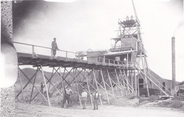
The A1 Gold Mine is located north of Woods Point, near Jamieson, in the Upper Goulburn region of Victoria. Gold was discovered at the A1 site in 1861 and mining operations began in 1864. The A1 Mine Settlement refers to a small township known variously as Castle Reef, Castle Point, and Raspberry Creek, which developed in the 1860s around mining industry centred on a crushing machine that worked the three gold reefs in the area. Historically, the name "A1"referred to the high quality of gold found in the quartz reefs at depths of at least two thousand feet. Along with the Morning Star mine at Woods Point, the A1 gold mine produced almost sixty percent of Victoria's gold output in the 1950s to 1970s and continued operating until 1992 when it went into administration. Operations at the site were revived in 2016 and the A1 Mine is now considered one of Victoria's premier gold mines. The A1 mine is part of the extensive and prospective Lachlan Fold Belt, a north-west trending belt of tightly folded Early Devonian sedimentary rocks extending from New South Wales to Victoria. Mineralisation is hosted within or immediately adjacent to diorite dykes. Contemporary development of the 'Queens Lode' at the A1 mine signals a move from high-grade, narrow vein airleg mining into larger scale, mechanical mining designed to increase ore production volume. This original, undated photograph of the A1 Mine appears to depict an area or phase of disuse or abandonment. The aged and humble appearance of the cottage suggests association with the historical A1 Mine Settlement, therefore the image may have been taken prior to the 1950s-1970s revival period in which the A1 mine is known to have produced high gold yields. The photograph contributes to our understanding of the A1 Gold Mine's impact on the landscape and the social, environmental impacts of mining on communities and may be compared with others in the Burke Museum's extensive collection of mining photographs to deepen our understanding of mining in the Jamieson area.Black and white rectangular photograph printed on photographic paperReverse: 5577 / A1 Mine / Near Jamieson / Vic. /burke museum, beechworth museum, beechworth, gold fields, gold rush, victorian gold rush, mining tunnels, gold ming history, colonial australia, australian gold rushes, mining technology, beechworth historic district, indigo gold trail, indigo shire, upper goulburn shire, jamieson, woods point-walhalla goldfield, a1 gold mine, victorian high country, modern mining methods, orogenic gold province, gold mineralisation, devonian, dykes -
 The Beechworth Burke Museum
Photograph - Photograph - Reproduction, ca. 1900
This image shows the approach to Beechworth from the south-west via the Newtown Bridge. Numerous early buildings line the road as it bifurcates to become Ford and High Streets on the ridge above Spring Creek and Newtown Falls. The sloping, rocky terrain and water course along the gorge show evidence of the intense mining activity that occurred at the site. The Ovens Gold Rush at Beechworth started when gold was found at Spring Creek in February 1852, prompting an influx of miners from around the world. The population grew over 20,000 by 1857. While the earliest mining at Beechworth was similar to that in other Victorian goldfields like Ballarat and Bendigo, Beechworth is notable for its use of hydraulic sluicing as a major method of removing wash-dirt. Hydraulic sluicing employs high pressure jets of water to blast away large areas of earth and wash it down to be run through a sluice box. Gold gets caught in the sluice and the remaining slurry is washed away. This method of mining is extremely effective but causes significant environmental impacts and damage to waterways. Large water quantities were required for large-scale sluicing, and the long water races and deep tailraces that were constructed in the Beechworth area in the nineteenth century are nonetheless considered feats of engineering. The site in the photograph is associated with the Rocky Mountain Mining Company who constructed an eight hundred meter tunnel under the township between 1876-1880 to reduce water levels at Spring Creek, which had been subject to diversions since the earliest days of alluvial mining. Over four million ounces of gold (115 tones) were found at Beechworth between 1852 and 1868, and the wealth from the gold rushes built Beechworth and the nationally significant buildings that remain standing today.This image shows the early development of the Beechworth township above Spring Creek, where gold was discovered in 1852. Evidence of hydraulic sluicing, a uniquely predominant method at Beechworth, and water-works engineering are present in the landscape. By the 1870s, alluvial gold deposits were depleted and increasingly complex engineering was required so deeper shafts could reach bedrock. This image is significant for understanding changes to the landscape and the evolution of mining methods and engineering practices related to the extensive construction, manipulation and management of water networks. The shift from smaller scale alluvial mining to larger company dominance in the mining industry has implications for understanding wider social, economic, political and industrial changes in the region of Beechworth and within the context of the Victorian Gold Rush more broadly. A black and white rectangular reproduction photograph printed on photographic paper. burke museum, beechworth museum, beechworth, gold fields, gold rush, victorian gold rush, hydraulic sluicing, rocky mountain mining company, spring creek, netwown falls, mining tunnels, water races, tailraces, colonial australia, australian gold rushes, mining technology, beechworth historic district, indigo gold trail, migration, indigo shire, gold mining, gold mining history -
 The Beechworth Burke Museum
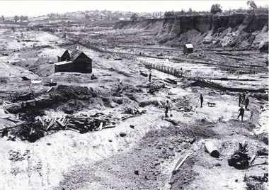
Photograph - Photograph - Reproduction
... Australian gold mining industry. Therefore, this image has ...This photograph depicts mining operations within the Beechworth area, in an unidentified valley where sluicing was utilised as a method for extracting gold from the environment. After gold was discovered in the region in 1851, sluicing became a characteristic of gold mining in the region - "Ovens miners carved intricate networks of races" throughout the region - involved the diversion of water in many channels, or water races, which contained inbuilt 'ripple devices' designed to trap gold for later extraction. By 1871, 900 miles of water races had been cut into the Beechworth Mining District. As suggested by the numerous figures involved in labouring along the water race, sluicing was a source of considerable employment within the region. This image is of important historical significance for its ability to convey information about sluicing and the methods used to find gold in the 1850s, and provides clues as to how sluicing and the widespread construction of water ranges changed the environment of the region. This image is important for current research into the history of the Ovens region in Victoria, which played such a prominent role in the early Australian gold mining industry. Therefore, this image has the capacity to be beneficial for research into society and the motivations of those living and working in this region during this period and therefore, has social significance. The Beechworth Burke Museum has additional images relating to gold sluicing and and the mining activities in the area more generally, which can be analysed and studied alongside images like this one.A black and white rectangular photograph printed on matte photographic paperbeechworth, mining, miners, labour, water race, sluicing -
 The Beechworth Burke Museum
Photograph - Photograph - Reproduction, Unknown
This image is a reproduction of an 1899 original depicting the 'Williams Good Luck Mine' on the Mopoke Reef (also called 'Morepork Gully') in the Dingle Ranges, approximately three miles from Beechworth. The foreground of the image is littered with piles of smashed rock and detritus, known as ‘mullock’, beside a reinforced mine shaft, a vertical access passageway allowing miners to enter the mine and haul ore out using lifting technology such as a poppet heads, whims or windlasses. A group of miners and a dog appear close to an open-sided miner’s hut. Following the discovery of gold at Beechworth in 1852, rushes quickly followed at surrounding creeks and gullies in the district. In the late nineteenth and early twentieth centuries, small syndicates of miners continued to work old or abandoned quartz reefs, often persisting without the assistance of heavy machinery to remove the large amounts of rock, in order to obtain yields at ever greater depths. The group of miners in this photograph are Mr. Roger Williams and Sons, who revived operations at the ‘Old Good Luck’ mine on the Mopoke Reef in the Dingle Range near Beechworth around 1892, working the site for more than two decades. An emigrant from Cornwall with experience in the tin mining industry, 19 year old Roger Williams senior sailed to New Zealand in 1840, then to Australia where he spent time in the Bendigo Gold Fields before settling in Beechworth in the early 1860s. Mr Williams senior worked on various mining activities in the district, including the Rocky Mountain Tunnel project. Conversant with the character of gold-bearing reefs in the area, the syndicate dug an eight hundred foot tunnel, digging down as far down as two hundred feet with little capital save their labour, to connect and provide better working access to the mass of reefs and veins in the vicinity. Progress was hampered by poor air quality charged with fumes from dynamite and large quantities of rock had to be crushed to obtain payable yields. The Victorian Goldfields are filled with ruins and remnants of the area's rich mining history, ranging from small alluvial diggings to the remains of huge mining companies. Site names often changed several times throughout the nineteenth and twentieth centuries. Some sites were abandoned and forgotten, others were worked continuously over many decades. The names of mines were often repeated at different locations throughout the Victorian Goldfields. For example, there is a Mopoke Gully heritage mine near Fryers Creek, Victoria. 'Mopoke' is a common onomatopoeic name for Morepork and Australian Boobook owls. This image has historical, social and research significance for patterns of emigration during of the Victorian Gold Rush, and the historical, social and environmental impacts of mining at Beechworth at the turn of the nineteenth and twentieth centuries. As gold became scarce and government support and large company investment waned, poor hard-working miners laboured intensively to make a living through periods of high unemployment. This image can be compared and studied alongside other historical mining photographs and objects in the Burke Museum Collection. It has potential to improve our understanding of miners working conditions and the shifting character of mining in the Beechworth district. Black and white rectangular reproduction photograph printed on matte photographic paper.Obverse: Williams Good Luck Mine Beechworth / Roger! / Reverse: 6858 / burke museum, beechworth museum, beechworth, gold fields, gold rush, victorian gold rush, gold ming history, colonial australia, australian gold rushes, mining technology, beechworth historic district, indigo gold trail, migration, indigo shire, good luck gold mine, victorian goldfields, mining syndicates, gold fever, quartz-mining, small-scale mining, old good luck mine, mopoke gully, quartz reefs beechworth -
 The Beechworth Burke Museum
Photograph, unknown
This reproduced photograph is of Pennyweight Flat near Beechworth, a notable area of the 1850's gold rush in Victoria. Donald Fletcher, migrating to Beechworth from Scotland in 1855, had substantial claims at Pennyweight Flat and was amongst the first in the district to utilise hydraulic sluicing and water diverting methods.The flat is said to have seen a flurry of 200 miners to the area around 1857, and by 1861 when work commenced on extending Fletcher's tail race the census recorded 644 people residing there (European males, females and Chinese). Pennyweight Flat is also significant for the cemetery that resides on the hilltop and which noted approximately 200 burials from the gold rush period 1852-1857, known for a long period as a children's cemetery due to the number of children's graves present.The search for gold is ingrained into the history of Victoria and therefore, images like this one which portray an open cut sluicing site can reveal important information for society and technology for the date when the photograph was taken. This image is of important historical significance for its ability to convey information about sluicing and the methods used to find gold in 1910. It also shows a location where sluicing was undertaken which provides insight into the impact of sluicing on the environment at a time when it was done. This image is important for current research into the history of Beechworth and surrounding area including Victoria's North East. The Rocky Mountain Extended Gold Sluicing Company was a long running and very active mine that was one of the most successful and largest in the district. Therefore, this image has the capacity to be beneficial for research into society and the motivations of those living and working in this region during this period and therefore, has social significance. The Beechworth Burke Museum has additional images relating to gold sluicing which can be analysed and studied alongside images like this one. When the mine closed in 1921, in a liquidation sale, Zwar purchased the tunnel and clear water supply that ran under the town of Beechworth. He directed the water to his tannery and over time built a major industry in leather works that was a major employer in Beechworth. In growing his leather business, Zwar installed crude oil engines for electricity in his factory. He oversaw working with local council to introduce electricity to Beechworth via a sub-station on Albert Street. In 1927 Electric street lamps replaced gas lamps in the streets of Beechworth. Black and white rectangular reproduced photograph printed on glossy photographic paperObverse: Reverse: 84.222.5/ digital print/ rocky mountain extended gold sluicing company, gold, sluicing, gold sluicing, hydraulic sluicing, gold mine, open cut mining, mining, gold mining, north-east victoria, beechworth, burke museum -
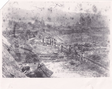
 The Beechworth Burke Museum
Photograph, 1857
This photograph is of old mine workings on the site of the Spring Creek diggings. Spring Creek is a contact zone for granite pluton and siltstones, shales and standstones; which has, over time, encouraged natural springs to form. Enriched with gold washed out of the surrounding granite, these alluvial deposits achieved fame from 1852 onwards as the Spring Creek Diggings sprang to life (not realised as geographically important until 1871). In Spring Creek that runs behind the main street of Beechworth, near the foot of Newtown Hill a pint pot of gold was discovered on one of these expeditions in 1852 by prospectors Baker and Strickland and the gold rush town of Spring Creek was formed. Australian gold rushes have always created a sense of independence and freedom; as do-it-yourself, off-grid, low-tech adventures. People of all backgrounds were drawn to the gold fields by the prospect of riches and adventure, but they also learned self-sufficiency and found freedom of expression. Industry boomed, new practices were adopted and social norms were upended. This image is of historical significance as it informs on the history of Australian gold mining. It represents the innovation that accompanied the mining industry and the importance of gold mining in town building and regional histories. Black and white rectangular photograph on unmounted board.gold mining, spring creek, mining, geography, geology