Showing 66 items matching "gold license"
-
 Bendigo Historical Society Inc.
Document - MINER'S RIGHT - SHOW YOUR LICENCE
... Handwritten notes Titled 'Show Your License'. License... DOCUMENT Gold miner's right Miner's Right Show Your License Royal ...Handwritten notes Titled 'Show Your License'. License introduced in 1851 at 30 shillings a month. All had to pay gold license. In 1855, the fee was abolished and was replaced by the Miner's Right. Also some newspaper reports: Duke of Edinburgh's visit, Engineers & Drivers Meeting, accidents, inrush of water at the Victoria Quartz.document, gold, miner's right, miner's right, show your license, royal hotel, young chum, comet, robin hood, extended hustlers, lazarus, sth belle vue, true blue, unity, garden gully united, victoria queen, david clapperton, thomas clapperton, new chum consolidated, gt ext'd hustlers, victoria quartz, new chum railway, new chum united, lansell's 222, lazarus, old chum, new chum & victoria, devonshire mines, belmont & saxby -
Canterbury History Group
Document - Collection of documents relating to the Snowden Family, c1853
... on the "Great Britain', 19 August 1852. Gold License for A., Snowden... for passage to Melbourne on the "Great Britain', 19 August 1852. Gold ...Mr Arthur Snowden's receipt for passage to Melbourne on the "Great Britain', 19 August 1852. Gold License for A., Snowden, February 1853, Shopping List, Report of and copy of invitation for the wedding of Mildred Snowden and Robert Arthur Demaine 23 November 1882. Article from The Age 29 June 1906 on the Great Britain.abbotsford, st helliers, canterbury, snowden family, demaine family, great britain (ship), licences -
 Orbost & District Historical Society
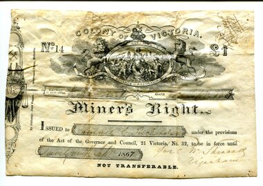
Certificate, September 1867
... Following a Royal Commission in 1855, the Gold License... gippsland Following a Royal Commission in 1855, the Gold License ...Following a Royal Commission in 1855, the Gold License was changed to the Miner’s Right, which reduced the fee and required annual payment, rather than monthly or quarterly.The fourth Goldfields Act, passed in early 1858, gave increased privileges to holders of Miner's Rights. These included the right to make residential claims, allowing the cutting of timber on claims and giving the right to build races and dams on any crown lands for mining purposes. This certificate is in the name of Samuel Richardson who brought it to Orbost.This item is of historical significance as it is associated with positive outcomes for gold miners brought about by the Eureka Stockade rebellion and its subsequent democrat changes. It is also associated with the Richardsonfamily who were early settlers in Orbost.A certificate for a miner's right printed on paper. It cost one pound. It was Not Transferable. Details have been filled out in ink. At the top of the licence is an elaborate etching, under the heading 'Colony of Victoria'. Inside a shield is a young woman, crowned, seated, with shipping in the background. oO her left is a miner with hat presenting her with a gold nugget while on her right, a farmer presents grain to her. Mottoes include 'Honi Soit Que Mal Y Pense'; 'Dieu et Mon Droit' and 'Advance Australia' There are handwritten notes in faded ink on the back.miner's right, colony of victoria, samuel richardson, no 14, government act -
 Bendigo Historical Society Inc.
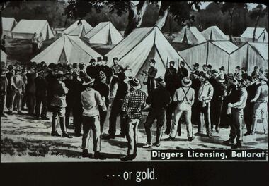
Slide - DIGGERS & MINING: THE GOLD LICENCE, c1850s
... . Slide: or gold. Diggers Licensing, Ballarat. Shows many tents... licence. The Government Camp. Slide: or gold. Diggers Licensing ...Diggers & Mining: The gold licence. The Government Camp. Slide: or gold. Diggers Licensing, Ballarat. Shows many tents in background, in front are diggers and police, some men in top hats. Markings: 11 994.LIF. 4 Used as a teaching aid.hanimounteducation, tertiary, goldfields -
 Federation University Historical Collection
Poster, Public Meeting at Ballarat to Fight TAFE Cuts, June 2012
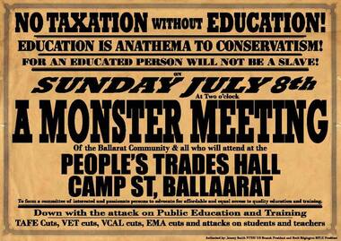
... an the gold license system in 1854. ... an the gold license system in 1854. university of ballarat national ...In October 2011 the Ballieu Government announced funding cuts to public and private technical training organisations as a cost saving measure. The government reduced funding for seven subject areas including business and clerical, finance and hospitality, totaling $300 million across the state. During a visit to Ballarat on 15 June 2012 Premier Ted Ballieu was met by hundreds of protestors angry at the TAFE cuts. It was expected that the Ballarat TAFE sector would be cut by $20million (or 40%), and up to 60 TAFE programs would be cut. A report in 'The Australian' on 01 June 2012 projected the TAFE cuts would result in the loss of almost 2000 jobs across the state. 'If the projections are correct, Victorian college redundancies would dwarf those in manufacturing and aviation, matching the worst predictions of job losses across Australia's entire banking sector.' Ballarat's National Tertiary Education Union (NTEU) and the Ballarat Trades and Labor Council (BTLC) are following up their earlier protest campaigns with a monster meeting to be held at Ballarat Trades Hall, Camp Street on Sunday 8 July. The monster meetings will take place in close proximity to Bakery Hill where over 10,000 diggers protested against an the gold license system in 1854. .1) A brown and black Monster Meeting poster based on the Eureka Monster Meeting poster. The post uses text similar to the 1854 Eureka Poster to advertise a meeting to fight TAFE cuts as announced by the Victorian Government led by Premier Ted Ballieu. .2) A white hand flier with red text calling on the people of Ballarat to attend a meeting at Ballarat Trades Hall to fight TAFE cuts. Both items are authorised by Jeremy Smith NTEU UB branch President and Brett Edgington BTLC President.university of ballarat, national tertiary education union, jeremy smith, monster meeting, brett edgington, ballarat trades and labour council, tafe, trades hall, ballarat trades hall, eureka, eureka stockade, union -
 The Beechworth Burke Museum
Photograph, c.1870
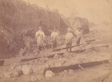
This photograph was taken in approximately 1870 and depicts four male miners standing in mining sluice at the Three Mile Goldfields. These men are wearing typical attire for 1870s gold miners. They wear white shirts, tan coloured pants with water proof shoes and most of the men are wearing an apron to prevent their clothing from becoming too dirty from the mud. Each man is wearing a wide brim hat and hold large wooden tools used for sorting through the sluice. Three of the four men have full beards. The photograph was donated to the Burke Museum by R. Ziegenbein before 2001 but the photographer and the individuals captured in the photo are unknown. The image depicts the landscape of the Three Mile Goldfields during a period when open cut sluicing was undertaken to reach gold. Open cut sluicing is a method used to extract gold and other precious metals from beneath the surface of the earth. This technique involved the use of high-powered hoses which broke down the soil enabling miners to come along and search this soil for gold. After the gold rush of the early 1850s, diggers had to enlist the assistance of heavy machinery and techniques like hydraulic sluicing in order to reach gold because the surface alluvial gold had already been discovered and removed. This heavy machinery was not used until after 1853. The Three Mile Goldfields was a site of rich alluvial gold deposits located about 5 km south of Beechworth in Victoria. Today, the location of this gold deposit is called Baarmutha. It was a popular area for gold mining in the 1850s but became largely abandoned by the following decade. In 1865, a man named John Pund recognized that the area could be potentially rich if a better water supply could be obtained. He secured a 15 year license with three other miners. Within the next five years, these men had constructed 19 km of water race going from Upper Nine Mile Creek to Three Mile Creek. By 1881, these four men had delivered 950,000 gallons to the Three Mile Sluicing area which is depicted in this photograph. Pund was later go into partnership with John Alston Wallace who would become owner of the Star Hotel in Beechworth. The Three Mile sluicing location continued to be operational until 1950. Sluice box workers were a vital part of gold mining regardless of how inefficient they were in the recovery of gold. After using hydraulic sluicing to cut away the earth, miners would use the big wooden boxes depicted in the image to catch the earth which would then be sifted for gold. However, accidents would occur often which would result in the gold washing away and unable to be recovered. It was not a very efficient system because the gold, which was alluvial and thus very fine, would often pass through the sluice box undetected.The search for gold is ingrained into the history of Victoria and therefore, images like this one which portray an open cut sluicing site can reveal important information for society and technology for the date when the photograph was taken. This image is of important historical significance for its ability to convey information about sluicing and the methods used to find gold in the late 1800s and early 1900s. It also shows a location where sluicing was undertook which provides insight into the impact of sluicing on the environment at a time when it was done. Images, like this one, of Australian gold rush history can reveal important information about the social and environmental impact of this period. This image depicts diggers standing in a mining location and therefore, this image has the capacity to reveal or support significant information for researchers studying the fashion and social status of diggers in Australia in approximately 1870. It can also provide information on the landscape of Australia in this period and the impact of mining for gold on both society and the Australian landscape. The Burke Museum is home to a substantial collection of Australian mining photographs which can be used to gain a deeper understanding into life on the gold fields, technology used in mining, the miners themselves and the impact of the gold digging on the environment.Sepia toned rectangular photograph printed on matte photographic paper and mounted on board.[illegible] about 1870 / 97 2514.1 / 2594 30three mile goldfields, goldfields, 1870, 1870 gold, australia, australian landscape, miners, gold miners, diggers, gold diggers, beechworth, victoria, sluice box workers, sluicing, sluice, mining -
 The Beechworth Burke Museum
Photograph - Photograph - Reproduction, W. D. Gibbon, Early 1900s
This photograph was taken in 1911 at Three Mile Creek, about five kilometers south of Beechworth town. Significant digging took place at this location from late 1855, which led to a flood of workers and stores to follow, though daily earnings were slim compared to the nearby Woolshed site. This remained the case even after workers at Three Mile Creek attempted to protest around Beechworth during an election in November 1855. Three Mile Creek was one of seven significant divisions of the Beechworth Mining District formalised by the Governor-in-Council in 1858, though by the time this photograph was taken, the boundaries of the original seven districts had shifted to create seventeen divisions. The Three Mile Goldfields was a site of rich alluvial gold deposits located about 5km south of Beechworth in Victoria. Today, the location of this gold deposit is called Baarmutha. It was a popular area for gold mining in the 1850s but became largely abandoned by the following decade. In 1865, a man named John Pund (a man second from the left in the back row of this photograph shares this surname) recognized that the area could be potentially rich if a better water supply could be obtained. He secured a 15 year license with three other miners. Within the next five years, these men had constructed 19 km of water race going from Upper Nine Mile Creek to Three Mile Creek. By 1881, these four men had delivered 950,000 gallons to the Three Mile Sluicing area which is depicted in this photograph. Pund would later go into partnership with John Alston Wallace who would become owner of the Star Hotel in Beechworth. The Three Mile sluicing location continued to be operational until 1950. The eleven miners in this photograph are: Back row: Led Guthrie, P. Pund, F. Beel, [Unknown] Miller Front row: Paddy McNamara, J. King, W. Beel, [Unknown] Garland, J. Clarke, J. Ryan, H. Bartsh In the background of the photograph is a huge dirt wall that appears to suffer damage caused by hydraulic sluicing. Hydraulic sluicing is a specialised mining technique that involves directing high pressure water flows at dirt to uncover gold. The technique played a significant role in shaping Beechworth's landscape during the gold rush to create the topography seen today.The search for gold is ingrained into the history of Victoria and therefore, images like this one which portray an open cut sluicing site can reveal important information for society and technology for the date when the photograph was taken. This image is of important historical significance for its ability to convey information about sluicing and the methods used to find gold in the late 1800s and early 1900s. It also shows a location where sluicing was undertook which provides insight into the impact of sluicing on the environment at a time when it was done. Images, like this one, of Australian gold rush history can reveal important information about the social and environmental impact of this period. This image depicts diggers standing in a mining location and therefore, this image has the capacity to reveal or support significant information for researchers studying the fashion and social status of diggers in Australia in approximately 1911. It can also provide information on the landscape of Australia in this period and the impact of mining for gold on both society and the Australian landscape. The Burke Museum is home to a substantial collection of Australian mining photographs which can be used to gain a deeper understanding into life on the gold fields, technology used in mining, the miners themselves and the impact of the gold digging on the environment.Black and white / sepia rectangular reproduced photograph printed on glossy photographic paper mounted on board.beechworth, beechworth museum, mining, mining team, three mile creek, sluicing, hydraulic sluicing, photography, gold sluicing, gold mining, pund mining -
 The Beechworth Burke Museum
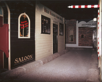
Photograph, c1990s
... (illegible)/ J. DAVIDSON/ LICENSE/ BANK OF VICTORIA/ GOLD BUYING...)/ J. DAVIDSON/ LICENSE/ BANK OF VICTORIA/ GOLD BUYING OFFICE ...Taken in the 1990’s, the photograph depicts an exhibition in Beechworth featuring a series of shop fronts or a streetscape inspired by the 1850s gold rush to Beechworth. Gold was discovered in the Beechworth area in 1852, leading to a significant rush to the area as diggers and hopeful migrants alike hoped to strike it rich. This gold rush to Beechworth, which was part of a larger and prolonged gold rush to the Victorian colony in the 1850’s, led to significant communal, social, and economic shifts in the area and the colony.This photograph contains historical and social significance, connecting with several themes such as gold mining, making regional centres, and marking significant phases of development for Victoria’s towns. The gold rush of the 1850’s was a significant historical phase for the Victorian colony that led to widespread social, economic, and communal changes as the population of the colony nearly tripled in size. The rush to Beechworth after the discovery of gold in 1852 was one of the earliest gold finds. The photograph depicts an interpretation of store fronts in Beechworth during the 1850’s following the gold rush, providing an example of the historical interpretation of the Beechworth gold rush in the 1990’s. The photograph also demonstrates the enduring importance of Beechworth’s gold rush history to the local community, who continued to demonstrate an interest in the Beechworth gold rush. Colour rectangular photograph printed on photographic paper.Obverse: DANCING EVERY NIGHT 8 P.M-6 A.M/ GOLD DIGGERS ARMS HOTEL/ STAR (illegible)/ SALOON/ EST. 1853/ BEECHWORTH GOLD (illegible)/ J. DAVIDSON/ LICENSE/ BANK OF VICTORIA/ GOLD BUYING OFFICE/ EST. 1856 (illegible) Reverse: 3306 gold rush, beechworth, exhibition, victorian colony, shops, store fronts, streetscape, saloon, gold buyer, hotel, store, bank of victoria, j. davidson -
 Orbost & District Historical Society
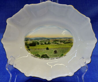
dish, 1950-1970
Small china pieces carrying scenic views of holiday destinations were a popular kind of souvenir during much of the 20th century. The pictures on the souvenirs ranged across natural beauty spots (beaches, waterfalls, rivers), civic buildings and monuments (town halls, war memorials), and indicators of local progress (commercial centres and occasionally even industrial sites). Ref: Powerhouse Museum Sydney.Small souvenir dish. White with gold edging and a picture of Orbost in bottom centre. Picture is a view from Grandview Heights. White, square, bone china dish with fluted rim trimmed with gold. In the centre of the dish there is a coloured transfer of a scene labelled as 'Sturt Street, Ballarat'. The scene shows grand Victorian buildings in the background, shops with verandahs and verandah posts lining one side of Sturt Street, trees on the other side of the street, and a tram in the foreground. A transfer on the underside gives manufacturer's information. Read more: http://www.powerhousemuseum.com/collection/database/?irn=12118#ixzz23rwkysrO Under Creative Commons License: Attribution Non-CommercialUnderneath- Royal Stafford -Bone China, Made in England, 3444 Top- Orbost From Grandview Heights, Vic.souvenir dish orbost grandview-heights crockery domestic stafford-royal -
 The Beechworth Burke Museum
Photograph, 1920-1950
This image taken between 1920-1930 depicts open-cut hydraulic sluicing at the Three Mile Mine, located about five kilometres south of Beechworth. Alluvial, or surface, mining began on this site in the 1850s, but was soon replaced by hydraulic sluicing methods. By the start of 1880 it is estimated that nine hundred miles of water races had been cut though soil and rock in the Beechworth district. Hydraulic sluicing employs high pressure jets of water to blast away large areas of earth and wash it down to be run through a sluice box. Gold gets caught in the sluice and the remaining slurry is washed away. Large water quantities were required for hydraulic sluicing, and the long water races and deep tailraces that were constructed were considered great engineering feats. This method of mining is extremely effective, but causes significant environmental damage and impacts to waterways and agricultural operations. Miners at Beechworth built extensive networks of races and dams to secure reliable supplies of water on a scale far greater than elsewhere in Victoria. By the 1880s Beechworth's water barons continued to hold more than half of all the water right licences on issue and undertook sluicing operations on a massive scale. The manipulation of surface and ground water via race networks was well planned and recorded in detail by local mining surveyors. The maps that were created, combined with modern geo-spatial technologies, provide a vital key in understanding the great lengths to which miners went to capture and control critical water resources. Today, Three Mile mine is called Baarmutha. The Three Mile Mine was unproductive until 1865 when John Pund and three other miners secured a fifteen year license and constructed a water race from Upper Nine Mile Creek to Three Mile Creek. In the early twentieth century Pund & Co. averaged over one thousand ounces of gold per year from the mine. After Pund's death in 1915, GSG Amalgamated Co operated the site, continuing sluicing until 1950. This image of hydraulic sluicing methods shows the extent of water-works engineering in the landscape. This photograph has historic and research potential for understanding changes to the landscape, the evolution of mining methods, and the extensive construction, manipulation and management of water networks in the Beechworth district. Black and white rectangular photograph on matte paperReverse: 7597-1 / Sluice Mining / Copied from original on loan from Webb (Qld) / Donated Nov 2009 / Baarmutha Three Mile Mine c1920-1950 / Managed by the Plain Bros then Parkinsons / Current Location is: Beechworth Animal Shelter / used for Baarmuthaburke museum, beechworth museum, beechworth, gold fields, gold rush, victorian gold rush, hydraulic sluicing, spring creek, netwown falls, mining tunnels, water races, tailraces, gold ming history, colonial australia, australian gold rushes, mining technology, beechworth historic district, indigo gold trail, indigo shire, john pund, water manipulation, water engineering, three mile creek, three mile mine, water race, large-scale mining methods, historical mining construction, alluvial mining, mining environmental impacts, baarmutha, water barons -
 Mission to Seafarers Victoria
Photograph - Photograph, Black and white, early 20th Century
Headstone inscription: "In Affectionate Remembrance / EBENEZER JAMES / late Chaplain to the Naval Forces of Victoria / and / The Victorian Seamen's Mission/ This stone is erected / by Friends of all nationalities and creeds as a mark of esteem for his unselfish and consistent Christian efforts for the social and moral advancement of our sailors/ and / in recognition of.... his indefatigable and praiseworthy exertions the stamping out in Victoria of the cruel degrading maritime curse of crimping was mainly due. / Born 11th of March 1841 Died 14th of July 1901/ "A good deed is never lost. He who sows / courtesy reaps friendship and he who plants kindness gathers love." Basil. The Headstone was found at the Melbourne Cemetery, Carlton in 2016. Rev James worked at Port Melbourne and Williamstown Missions but was also a regular visit to Geelong and other coastal ports and beside encouraging fortnightly entertainments and Chapel services, actively shipvisiting to meet with Seamen.This image documents in full the inscription on this commissioned marble headstone marking the grave of a significant figure, the second Chaplain at Port Melbourne, and an important figure in the development and story of not only the Mission to Seafarers in Victoria but also in the life of the Naval Force of Victoria prior to Federation. Rev James was not only an influential figure in the stamping out of crimping, the exploitation of seamen, but also actively worked with government and community to improve the quality of life by active lobbying for the controlled licensing of hotels and liquor sources to limit the incidence of drunkeness rife in the Ports and Wharves of Victoria in the late 19th Century. See also MTSV 0030Large Sepia photograph on paper mount features an Inscribed marble Headstone and grave with a stone facing and surround supporting low decorative cast iron railing. There are flowers and ferns on the grave.Across edge of grave in White upper case: J ROBINSON CARLTON appears to be over printed, the Sepia image may be a copy of an original photograph. Inscription on the headstone can be read, see full wording below in History field. on the paper mount below lwr edge of Photograph: "T. TENNENT 'PHOTO-GOLD TS' COLLINGWOOD"ebenezer james, chaplains, seamen exploitation of, naval force, victoria, melbourne cemetery, carlton, maritime crimping, ebenezer james (1841 - 1901), carlton, mission to seamen, seamen's mission, mission to seafarers -
 Kiewa Valley Historical Society
Folder - Cattlemen Families, Cattlemen of the High Plains
The Ryder and Edmondson families lived in the Kiewa Valley and had grazing licenses and huts on the Bogong High Plains.Pioneer families of the Kiewa Valley and Cattlemen of the Bogong High Plains.Plastic red folder with transparent front held by 2 gold metal slide clips. 16 clear plastic sheets holding 17 pages of photocopied print and pictures, 1 family tree, 1 photocopied photo, 1 birth document, 1 printed page, 3 photocopied letters and 7 printed pages. ryder family; edmondson family; kiewa valley -
 Phillip Island and District Historical Society Inc.
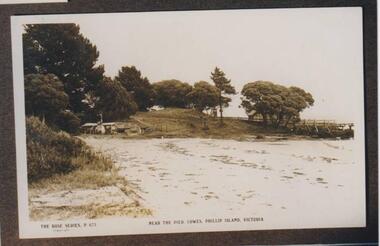
Photograph, George Cox's Shed, Cowes Beach, Phillip Island, 1914
George Cox was in Gibraltar with the British Navy when he heard about "gold" in Australia. In his latter days, as the mailman, he was granted a fisherman's license which enabled him to build a hut on the foreshore below the Isle of Wight and eastward of the Jetty. This is shown in the photograph.Scene of beach and tongue of land leading to the beach. The Jetty shed is mostly obscured by trees. George Cox's hut is tucked into the sweep of corner on the foreshore, large trees behind it.The Rose Series P 673 Near the pier Cowes, Phillip Island, Victorialocal history, photographs, george cox's hut, cowes foreshore, sepia photograph, betty kus collection, george cox, mailman, foreshore hut, phillip island, bruce bennett -
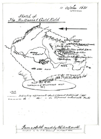 Federation University Historical Collection
Plan, Sketch of Ballaarat Gold-Field, 1851, 11/10/1851
The sketch was made by A.C. MacDonald, F.R.G.S. and presented to James Oddie, who was one of the earliest gold diggers at Ballarat..1) Reproduction of a line sketch plan of the Ballarat goldfield as it was on 11 October 1851 as drawn by A.C. MacDonald, and recopied by C.M. Yelland. The dots indicate appoximate extent of the Ballarat Goldfield in 1851. The dot and dash line indicates approximate area covered with tents. .2) Includes an indication of the locality of the Township of Baallarat West in 1867. Verso of cat. No. 4296.2, and written by Keith Rash - "On 10th October 1851, 1,300 licenses had been issued. 30th October 1851 2246 licenses. Lieut. Gov. LaTobe letter to Earl Grey." james oddie, a c macdonald, gold commissioner, mcleod, alfred clark, kavanagh, willis, highett, yarrowee river, a.c. macdonald, ballarat goldfield, ballaarat goldfield, lamda, c.m. yelland -
Federation University Historical Collection
Booklet, George Skinner (Acting Government Printer), Mineral Statistics of Victoria for the Year 1874, 1875
White Foolscap printed Government document relating Victoria's mineral statistics.mineraal statistics, statistics, angus mackay, gold exports, ballarat, beechworth, sandhurst, maryborough, castlemaine, ararat, gippsland, silver, tin, copper, antinomy, lead, iron, coal, lignite, kaolin, flagging, slates, magnesite, diamonds, sapphires, robert brough smyth, miners, machines, gold yeild, water rights, gunpowder, mining companies, mining divisions, wages, miners' rights, miners rights, business licenses -
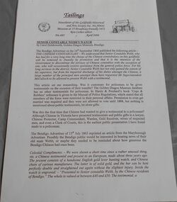 Bendigo Historical Society Inc.
Newsletter - Senior constable Webb's watch
Richard John Webb (c. 1832-1906) was the Senior Constable of the Chinese Constabulary in Bendigo in the 1850's. He was promoted to Dunolly and the rank of Sergeant in late 1860. In 1864 he was made the keeper of the gunpowder magazine at Dunolly. He married Kate Corbett in 1867 and they had 3 children; James Ramsay (1868-1929),Annie Harriet (1869-1950) and Kate Margaret Irene (1874-1963). Neither of the girls married and James became a doctor. Following his time at Dunolly, Webb was transferred to Eaglehawk and thence to Gippsland where he served at Bairnsdale. He retired as a Superintendent of Police and died in Melbourne. He was made an inspector in the Metropolitan Police District in 1888 and the Inspector of Licensing for Gippsland in 1894.Article by Carol Holsworth that appeared in the newsletter of the golden dragon museum in April 2006 titled "Senior constable Webb' watch". Also, a letter from relatives and six photographs of the gold watch and a silver teapot.constable webb, watch, chinese museum -
 Bendigo Historical Society Inc.
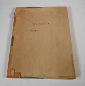
Administrative record - Application Register
The book original cover is dark green that has been wrapped in brown canvas to protect it. It has a leather spine with red and black labels. The pages in the volume are divided in columns: 1) Number of application, 2) Date of registry, 3) Date of application, 4) Surname, 5) Christian name and address, 6) Parish, 7) Allotment, 8) Section, 9) rea, 10) Local land board schedule, 11) Decision, 12) Special condition, 13) License, 14) References and remarks. The dates of the applications are from 30th August, 1874 to 26th April, 1876.On the front canvas cover: sec 173/174 3420. On the spine red label with gold letters: Application register. A black label with gold letters: all other sections land act 1901 (some of the letters are damaged)application register, land act 1901, 1874 to 1876 -
 Bendigo Historical Society Inc.
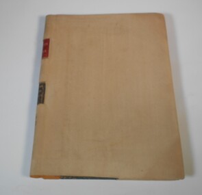
Administrative record - Application Register
The book is covered in a beige canvas to protect it. It has a leather spine with red and black labels. The pages in the volume are divided in columns: 1) Number of application, 2) Date of registry, 3) Date of application, 4) Surname, 5) Christian name and address, 6) Parish, 7) Allotment, 8) Section, 9) rea, 10) Local land board schedule, 11) Decision, 12) Special condition, 13) License, 14) References and remarks. Only two pages are used dated from 1908 are related to Swan Hill.On the spine red label with gold letters: Application register. A black label with gold letters: all other sections land act 1901. Also, on the spine in black texter 01 to 01 to - B - 145,187application register, land act 1901, 1908 -
 Bendigo Historical Society Inc.
Administrative record - Application Register
The volume has green front and back cover. It has a leather spine with red and black labels. The pages in the volume are divided in columns: 1) Number of application, 2) Date of registry, 3) Date of application, 4) Surname, 5) Christian name and address, 6) Parish, 7) Allotment, 8) Section, 9) rea, 10) Local land board schedule, 11) Decision, 12) Special condition, 13) License, 14) References and remarks.On the spine red label with gold letters: Application register. A black label with gold letters: all other sections land act 1901. Also on the spine in red texter "Stock Lith."application register, land act 1901 -
 Bendigo Historical Society Inc.
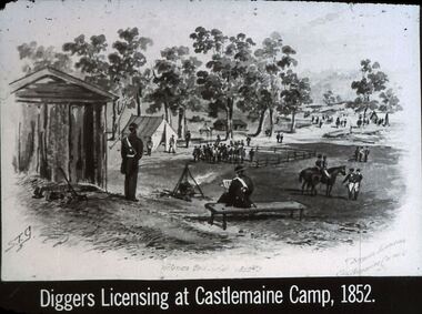
Slide - DIGGERS & MINING. THE GOLD LICENCE, c1850s
Diggers & Mining. The gold licence. The Government Camp. Slide: Diggers Licensing at Castlemaine Camp, 1852. Slide shows sketch by STG, has wooden structure for Commissioner, tent in background for miner, and miners. The Commissioner and his men are also in the picture. Markings: 12 994.LIF. 4. Used as a teaching aid.hanimounteducation, tertiary, goldfields -
 Bendigo Historical Society Inc.
Document - MCCOLL, RANKIN AND STANISTREET COLLECTION: LEASE REGULATIONS
Hard cover folder with gold lettering 'Lease Regulations' containing Mines Act 1915 No. 2198 (in force 1916) Requirements in connection with application for mining lease (1930). Application for registration as a Gold Producer (Mines Act 1928). Requirement in connection with an application for a mining lease and water right license or a license to treat tailings. Application for a Tailings License.Mines Dpartmentgold mining, miners' safety cage, lease regulations, gold mining, lease regulations -
 Federation University Art Collection
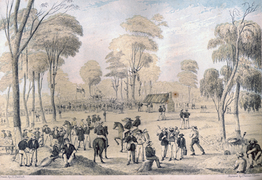
Print - Printmaking - Lithograph, Tulloch, David, 'Great Meeting of Gold Diggers Dec 15th 1851' by Thomas Ham, 1852
One of the first large goldfield meetings was at Castlemaine in 1851. After the extraordinary success of the Mt Alexander Diggings the Government issued a proclamation, raising the licence fee from thirty shillings to three pounds. As soon as these intentions became known a public meeting of miners was held. For miles around work ceased, with diggers travelling as far as Bendigo to attend the meeting. It is estimated that around 18,000 people attended the meeting. The notes with the engraving state The trees in this locality are chiefly Stringybark; some of them are peeled of their covering, as many persons prefer erecting bark huts to living in a comfortless tent. The various groups, and costumes of the men, are characteristic of our gold digging community. This item is part of the Federation University Art Collection. The Art Collection features over 2000 works and was listed as a 'Ballarat Treasure' in 2007.Colour lithograph of a meeting of diggers at a meeting in Mt Alexander. The meeting was the result of goldfields agitations against the license fee. lower centre "Great Meeting of Gold Diggers Dec 15th 1851" lower left side "Drawn By D. Tulloch" lower right side "Engraved by Thomas Ham"art, artwork, ham, thomas ham, tulloch, castlemaine, goldfields agitation, printmaking, edition, coloured lithograph, david tulloch, gold pan, shovel, wheelbarrow, waggon, bark hut, ring barked tree, gold mining -
 Port Fairy Historical Society Museum and Archives
Photograph
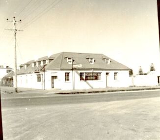
In 1844 a carpenter called David McLaws secured the lease on the land on the south west corner of James and Bank Streets. He later converted this to freehold by which time he had erected the Caledonian Inn. This building has been continually licensed since that time , and is believed to be the longest continual license held in Victoria. The dormer windows in the part of the building facing James street hide the fact that there is only a skeleton of rooms that were meant to be built there. They were unfinished because the labourers left town when gold was discovered at Ballarat in 1853. An advertisement for the time says “There were four parlours, a bagatelle room, eight bedrooms, a detached kitchen, stable and kitchen garden”. Well known hotel Thought to be the oldest continuously licenced hotel in VictoriaBlack and white photograph of 2 story building with dormer windows on corner hotel, building, james street, bank street, david mclaws -
 Port Fairy Historical Society Museum and Archives
Photograph
In 1844 a carpenter called David McLaws secured the lease on the land on the south west corner of James and Bank Streets. He later converted this to freehold by which time he had erected the Caledonian Inn. This building has been continually licensed since that time , and is believed to be the longest continual license held in Victoria. The dormer windows in the part of the building facing James street hide the fact that there is only a skeleton of rooms that were meant to be built there. They were unfinished because the labourers left town when gold was discovered at Ballarat in 1853. An advertisement for the time says “There were four parlours, a bagatelle room, eight bedrooms, a detached kitchen, stable and kitchen garden”. Well known Hotel thought to be the longest continuous licenced hotel in VictoriaBlack and white photographhotel, bank street, port fairy, james street, building -
 Wodonga & District Historical Society Inc
Photograph - Mac's Hotel, Wodonga, c1870s
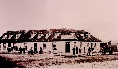
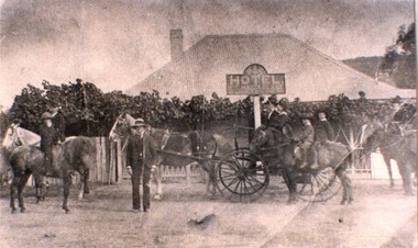
“Mac's Hotel" in Wodonga West, one of Wodonga's earliest hotels, was owned by William Christie McFarlane who arrived in Melbourne in December 1854 from Stirling, Scotland. He spent his first three years mining for gold at Beechworth. For the next three years he was the manager of the King’s Hotel at Wooragee, which was owned by his father-in-law, Charles David King. In 1860 he bought 180 acres of land at Wodonga, eventually extending his holdings to 1,000 acres on which he farmed. He called his property “Abbey Craig” after his home in Scotland. In time he owned several properties in Wodonga, a small vineyard and 'Mac's Hotel'. Mac’s Hotel was a popular meeting place for teamsters and other travellers on the Sydney Road. It opened in the early 1860s and the license was at times in the name of W. C. McFarlane and at other times held by his wife, Mary McFarlane. William had several positions during his life in Wodonga including serving as Postmaster and conducting a Commission and Insurance Agency business. He was appointed Secretary to the first Wodonga Building Society. W. C. McFarlane also filled the position of Sheriff’s Officer, Registrar of Births and Deaths and Marriages, and Justice of the Peace. W. C. McFarlane served as a member of the Wodonga Shire Council for several years including three terms as Shire President: 1889-90, 1890-1891 and 1894-95. He passed away in Wodonga in December 1906. After his death, the license of Mac’s Hotel continued to be held by Mary McFarlane until her death in November 1910. The license was not renewed and the hotel was taken over as a residence by their son, Walter McFarlane. Unfortunately, on 25 January 1913, Walter was assisting neighbours fighting grass fires about 3 miles away when his own home was completely destroyed by fire, bringing to an end the long history of the popular hostelry, Mac’s Hotel.This image is significant because it documents an early business in Wodonga conducted by a prominent Wodonga resident.Black and white image of people standing, on horseback and in coach outside Mac' Hotel, West Wodongamac's hotel, hotels wodonga -
 Australian Gliding Museum
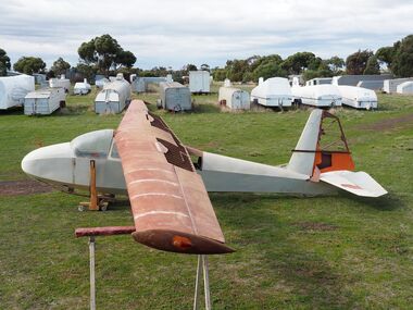
Machine - ES56 Nymph Sailplane
ES 56 Nymph Following the successful introduction of the ES 52 Kookaburra two-seater in mid-1954, Edmund Schneider Ltd designed a higher performance single seat sailplane of similar construction and with similar handling qualities. It was designated the ES 56 and became known as the ES56 “Nymph”. The ES56 Nymph was a success in that it delivered the anticipated performance and was found to have satisfactory flying characteristics. However, only the prototype (“Nymph -I”) and three production examples (“Nymph-II”) were built. Schneiders made some changes to the design before building the production version. The wing chord at the tip on the prototype measured 650 mm. This was reduced to 500 mm for subsequent builds. The explanation is that provision was made in the original design for the possible lengthening of the tapered wing to 13 metres. However, apparently it was decided to retain the 11.900 metre span which allowed the tip chord to be reduced slightly. Other changes included the installation of scissor type air brakes in the wing instead of simple hinged flap spoilers and the addition of a landing wheel behind the skid on the fuselage. On one of the Nymph-II a dorsal was added on top of the fuselage forward of the vertical fin when repairs were made rectifying damage incurred as a result of an accident at Benalla on 31 March 1963. Even before these ES56 gliders were finished, Edmund Schneider Ltd decided to offer a less expensive single seat design to cater in particular for newly solo pilots, the ES57 Kingfisher. With the Kingfisher, Schneiders reverted to a traditional airfoil (Gott 549) for the wing instead of the laminar flow section that was chosen for the Nymph in the pursuit of performance. As such, the Kingfisher was more appropriately characterised as a single seat version of the Kookaburra in comparison to the Nymph. Schneiders continued for a time to offer the ES56 Nymph as a high-performance sailplane. However, its place in the market was soon overtaken by imported designs with superior performance, such as the Schleicher KA6, which Schneiders also imported and built under license. Nymph-I was test flown in December 1955 and entered by Harry Schneider into the gliding championships held at Waikerie from 5th to 16th of that month. Harry finished 12th in the individual placing out of a field of approximately 24. The capabilities of the Nymph were further demonstrated by Harry Schneider in January 1956 with a Gold C flight of 193 miles from Gawler in South Australia to Walpeup in Victoria. Nymph-I was acquired by the Port Pirie Gliding Club in South Australia. It has been saved and restored and is a regular feature at vintage glider rallies in Victoria and New South Wales. See Museum Newsletter No 35 Winter Edition 2017 pages 3 -6, for that story. The Nymph-II production models were delivered by Edmund Schneider Ltd in October 1956 to the Gliding Club of Victoria, the Victorian Motorless Flight Group and the Royal Australian Navy Gliding Association. The VMFG flew its Nymph in the First National Gliding Championships at Tocumwal, NSW, in December 1956 and all three were flown at the Second National Gliding Championships at Benalla in 29th December 1958 to 8th January 1959, delivering competitive performances based on handicap. Nymph-I Serial Number 17 Original owner – Port Pirie Gliding Club, S.A. Registered VH-GHG on 20 August 1957 Re-registered VH-GHA on 11 October 2016 Currently Raywood, Victoria Believed airworthy Nymph-II Serial Number 20 Original owner – R.A.N. Gliding Association Registered VH-GDX on 20 May 1957 Currently Locksley, Victoria. In storage Nymph-II Serial Number 21 Original owner – Gliding Club of Victoria Registered VH-GHU on 27 August 1957 Currently Bendick Murrell, N.S.W. In storage Nymph-II Serial Number 22 Original owner – Victorian Motorless Flight Group Registered VH-GFE on 5 March 1957 Currently Bacchus Marsh, Victoria Under restoration for display. The Museum’s exhibit is the ES56, serial number 22, registered as VH-GFE. The glider was flown by the VMFG in Victoria until approximately September 1968. GFA records show that it was transferred to Queensland in 1968, and it passed through several owners until the mid-1970s. Information received indicates that it was flown by the Leichardt Soaring Club at Mount Isa in the (late?) 1960s. The history from then is not presently known except to say that it has been kept in dry storage for many years. It is not known when the glider was last flown. What is Significant? The Schneider ES 56 Nymph single seat sailplane, serial number 22, designed and built in 1955-1956, by Edmund Schneider Ltd in Adelaide. It was delivered to its original owner, the Victorian Motorless Flight Group, in October 1956, and registered as VH-GFE on 5 March 1957. How it is Significant? The ES56 Nymph is of historical, aesthetic, scientific and research, and social significance to the Australian gliding community. Why it is Significant? The ES56 is of historical significance as it was designed and built by Edmund and Harry Schneider. The Schneiders immigrated to Australia after the end of the second world war bringing with them considerable expertise in relation to glider design and construction. Over the following decades they maintained a close association with the Gliding Federation of Australia and the gliding clubs and through their glider production made a major contribution to the sport. The ES56 is part of that story. The ES56 in its design and construction exhibits the glider construction technology of the time, which principally consisted of lightweight wooden framework skinned with ply and doped fabric. It exbibits design innovation, notably the use of a laminar flow wing profile in pursuit of better glide performance. Also, considerable attention was given to simplifying the structure in order to keeping cost and the weight low. The ES56 played a useful role at gliding clubs where it was operated, especially the late 1950s and early 1960s and is remembered well by pilots who flew her. The glider is in the course of restoration and provides an insight into the skills and workmanship that were involved in design, building and maintenance of these wooden aircraft. It is of aesthetic and scientific and research significance. Glider airframe of a traditional wood and fabric covered constructionNoneglider, sailplane, edmund schneider, harry schneider, es56, nymph, es57, kingfisher, victorian motorless flight group, gliding club of victoria, ran gliding association, port pirie gliding club, leichardt soaring club. -
 Eltham District Historical Society Inc
Photograph - Digital Photograph, Alan King, Eltham Court House, 730 Main Road, Eltham, 28 December 2007
The Eltham Court House is Eltham's oldest public building. It was classified by the National Trust in 1977. In 1857 five Eltham residents petitioned the licensing magistrates of the Heidelberg district asking for better police protection, including from itinerant gold prospectors who turned to crime when their quest was unsuccessful. In response the Eltham Courthouse was constructed in 1860. Over the years it has also been used for other activities, including for electoral polling purposes, inquests, early meetings of the Eltham Roads Board and even as an overflow classroom. This type of localised solution is characteristic of the self-reliance preserved in Eltham today. The court house is an important symbol of the spirit which makes Eltham distinctive as a community. The Eltham Courthouse is historically significant because its construction was intended to emphasise the centralised control over law and order in the Colony of Victoria in the wake of the 1852 Snodgrass committee report on the Victorian police force and the resulting Police Regulation Act (1853). The nature of the Court House planning and use of architectural devices make the building's function easily interpreted. The arrangement of rooms, with public entry and clerical rooms to the rear, and the use of raised floor levels throughout these spaces to signify relative rank is easily perceived. The distinction in entries, public, magistrate and person-in-custody, and the existing court furniture enhances appreciation of this building. The Eltham Court House is one of only two intact examples in the state of this simple design with projecting entry. The building is of architectural significance because it retains intact early features. These include use of handmade bricks, simple decoration, roof trusses, timber ceiling boards, original windows, doors and associated hardware and a collection of court furniture. Additions to the court house have been done in a manner which did not interfere with the fabric of the original building. Typical cases heard before the Court of Petty Sessions included financial debt, straying livestock, theft, assault, drunkenness, public disorder, truancy, motor vehicle offences, unregistered animals and failing to have children attend school, or be vaccinated. The courthouse operated for over 120 years before it closed in 1985. In April 2021, Nillumbik Shire Council authorised restoration of the building and furnishings. The extensive works required for the total restoration of this highly valued heritage building was undertaken by Ducon Building Solutions and other specialist contractors. Covered under Heritage Overlay, Nillumbik Planning Scheme. Victorian Heritage National Trust of Australia (Victoria) State significance Published: Nillumbik Now and Then / Marguerite Marshall 2008; photographs Alan King with Marguerite Marshall.; p65 A demand for better police protection resulted in the building of the Eltham Courthouse and the police residence beside it. In 1857 five Eltham residents petitioned the Heidelberg district licensing magistrates. They pointed out that Eltham had two hotels, a population of about 1000, and many strangers employed on the public roads. Yet the nearest police were at Heidelberg eight miles (12.8km) away, or at the Caledonia Diggings 21 miles (33.7km) away.1 Subsequently the courthouse and then the police residence, near the corner of Main Road and Brougham Street, were built in 1859/60. The courthouse is Eltham’s oldest public building and the National Trust classified it in 1977. It ceased operation in 1984 and has since been used by local groups. There are only six other known examples of similar small brick country courthouses in Victoria . For £536, a Mr Duncan built the courthouse – a neat, narrow, oblong building with handmade orange bricks. Its gabled roof and porch are covered with brown slate tiles and it has 12-paned windows. Inside, the roof is peaked and the courthouse is still ventilated by oblong slits near the ceiling. Most of the fine carved timber and upholstered furniture is original. The original prisoners’ door, now permanently closed, led from the police station to the dock. Builders, Langridge Wright and Witney built a timber police station (since demolished) and a brick residence to its north,2 for £1150/7/-. Built around the same time were the lock-up behind the residence, also later demolished, and the two-storey orange brick stables. The former police residence also has a brown slate roof and handmade bricks. The front veranda roof is made of corrugated iron, as is the roof of the back weatherboard extension. The application for police protection was approved within a few months and police operated from a cottage rented at ten shillings a week and owned by William Jarrold. This was probably the one at the corner of Main Road and Dalton Street called Jarrold or White Cloud Cottage. In 1858 a second constable was appointed to Eltham following a fight at the hotel. The timber police office a replica of which was built in the early 1990s is at the building’s side. The lock-up was demolished following the relocation of the police to a new station in about 1952. The residence has been used as the Eltham District Historical Society centre since 1997. Records show court cases were held at Eltham before the courthouse was built, but the location is unknown. Some court cases were not very different from those today. In 1891 a man was charged with being drunk while in charge of a horse and was fined ten shillings. The courthouse was used for other purposes during its long history. It was probably used as a polling place as indicated by old photographs of election-day crowds outside. The Eltham Road Board met there from the early 1860s until 1868 when the Board transferred to Kangaroo Ground. During the same period the Road Board Secretary used the courthouse as an office until 1867 when it was transferred to his home at Wingrove Cottage. The courthouse was also used as an overflow classroom for the Dalton Street school in 1875. The two buildings can further link us with Eltham’s early days through Police Department correspondence. The first constable-in-charge was George Reid. In 1860 a letter to The Argus newspaper signed ‘A Sufferer’ declared the Eltham police were not active enough in their duties. The writer suggested that the ‘very snug’ police quarters were too comfortable, and he detailed various incidents including one of an alleged break-in to the Road Board Secretary’s home. But the Board Secretary, C S Wingrove, wrote to the Police Department refuting The Argus letter saying he had received full co-operation from Sen. Constable Peter Lawler.This collection of almost 130 photos about places and people within the Shire of Nillumbik, an urban and rural municipality in Melbourne's north, contributes to an understanding of the history of the Shire. Published in 2008 immediately prior to the Black Saturday bushfires of February 7, 2009, it documents sites that were impacted, and in some cases destroyed by the fires. It includes photographs taken especially for the publication, creating a unique time capsule representing the Shire in the early 21st century. It remains the most recent comprehenesive publication devoted to the Shire's history connecting local residents to the past. nillumbik now and then (marshall-king) collection, eltham, eltham court house, main road -
 Bendigo Historical Society Inc.
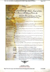
Book - BENDIGO GOLDFIELDS PETITION 1853
The 1853 Bendigo Goldfields Petition, containing names of Gold Diggers and other residents, to his Excellency Charles Joseph La Trobe Esq Lieutenant Governor of the Colony of Victoria with their grievances regarding license fees & other matters.gold, goldfields, mining licences, history-australia-victoria-bendigo-gold miners. -
 Bendigo Historical Society Inc.
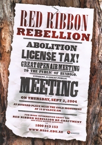
Poster - RED RIBBON COLLECTION: RED RIBBON REBELLION POSTER
In 1853, Bendigo Miners protested against the 30 shilling miners licence the had to pay the government. They wore red ribbons to show their protest and shopkeepers hung red ribbons outside their premises in support. Thousands of miners signed a petition to Governor LaTrobe to no avail. A protest gathering in Pall Mall marched to the Government camp on Camp Hill but this was a peaceful event again to no real avail.Poster produced the Bendigo Historical Society, supported by Bendigo Senior Seconday College, advertising the re-enactment of the Red Ribbon Rebellion (also referred to as the Red Ribbon Agitation) 'Abolition of the license tax, great open air meeting to the public of Bendigo' Held on Thursday September 2, 2004. Poster printed in maroon and black.bendigo, gold mining, red ribbon rebellion -
 Bendigo Historical Society Inc.
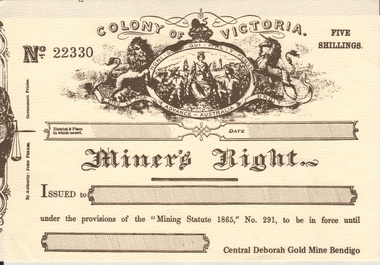
Document - COPIES OF COLONY OF VICTORIA MINER'S RIGHTS, unknown
... Right License Central Deborah Gold Mine Bendigo ( copy... Miners Right License Central Deborah Gold Mine Bendigo ( copy ...Colony of Victoria No. 22330 Cream & Sepia Paper Miners Right License Central Deborah Gold Mine Bendigo ( copy, not original ) Five Shillings. Issued under the provisions of the ''Mining Statute 1865'', No. 291. 3 Copies. At the top of the license is the Royal Coat of Arms with the motto ''Dieu Et Mon Advance Australia Droit'' which translates to ''God and my right to Advance Australia.'' In the centre of an oval is an image of the queen ruling over Victoria colonists. At the top of the oval is the motto of the Caledonian Mining Expedition Company ''Honi Soit Qui Mal Y Pense'' which is also the motto of the Order of the Garter and translates to ''Shamed be he who thinks evil of it.''By Authority: John Ferres Government Printerbendigo, mining, central deborah mine miners right, newspaper cuttings folder previous numbers 51-100