Showing 49 items matching "government land sales"
-
 Federation University Historical Collection
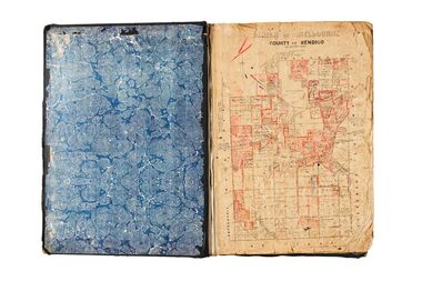
Document, Crown Lands in Villiers and Westward Counties, 1856-7, 1856-7
Blue foolscap printed Government document lon Crown lands in Villiers and Westward Counties. It inlcudes the return shoiung number of acres of land sold and the amount received for same. land, land sales, villiers, heytesbury, hampden, normanby, dundas, follett, crown lands -
Federation University Historical Collection
Document, Crown Lands Act, 1862, 1862
Blue foolscap printed Government document on the Crown Lands Act. land, land sales, crown land, ararat, petition -
Port Melbourne Historical & Preservation Society
Document - Notice, Auction, Crown Lands, 1892
Auction notice of Crown lands, 1892town planning, land sales -
Port Melbourne Historical & Preservation Society
Certificate - Title, Crown allotment 2, section 29, Town of Port Melbourne, Office of Titles, Victoria, Jul 1891
Certificate of title relating to Crown allotment 2, Section 29, Town of Port Melbourne, Heath Street. Title in name of Melbourne Permanent Building Society. registered 29th July 1891. title UDL 957, Folio 191304local government - town of port melbourne, town planning, land sales -
Koorie Heritage Trust
Book, Bonwick, James, Discovery and Settlement of Port Phillip; being a history of the country now called Victoria, up to the arrival of Mr. Superintendent Latrobe, in October, 1839 by James Bonwick; revised, at request, by W. Westgarth, 1856
Contents: Discovery of Port Phillip; First Settlement of Port Phillip; Abandonment of the Colony of Port Phillip; Further discoveries in the Country; Hume and Hovell's Overland Trip; Settlement of Western Port; Captain Sturt on the Murray; Major Mitchell's Australia Felix; The Successful Settlement of Port Phillip; Batman and Gellibrand's Application; Settlement of Portland Bay; Life of Batman; Batman's visit to Port Phillip; Fawkner's Yarra Settlement; Mr. Wedge's Narrative; William Buckley; The Association and Government; Progress of the Settlement; Flocks and Flock-masters; Government; Stewart, Simpson, Lonsdale, Latrobe; The Land and Land Sales; Law, Police and Port; Commerce, Trade and Shipping; Melbourne and Geelong; Hotels and Licences; Amusements; Rise and Progress of the Port Phillip Press; Religion in Port Phillip.142 p. : 1 fold-out map. ; 21 cm.Contents: Discovery of Port Phillip; First Settlement of Port Phillip; Abandonment of the Colony of Port Phillip; Further discoveries in the Country; Hume and Hovell's Overland Trip; Settlement of Western Port; Captain Sturt on the Murray; Major Mitchell's Australia Felix; The Successful Settlement of Port Phillip; Batman and Gellibrand's Application; Settlement of Portland Bay; Life of Batman; Batman's visit to Port Phillip; Fawkner's Yarra Settlement; Mr. Wedge's Narrative; William Buckley; The Association and Government; Progress of the Settlement; Flocks and Flock-masters; Government; Stewart, Simpson, Lonsdale, Latrobe; The Land and Land Sales; Law, Police and Port; Commerce, Trade and Shipping; Melbourne and Geelong; Hotels and Licences; Amusements; Rise and Progress of the Port Phillip Press; Religion in Port Phillip.victoria -- history -- to 1834. | victoria -- history -- 1834-1851. | melbourne (vic.) -- history -- to 1834. | melbourne (vic.) -- history -- 1834-1851. -
Southern Sherbrooke Historical Society Inc.
Map - photocopy, Woodcock & McCormack, civil engineers & architects & surveyors, The Major Estate, Belgrave
A photocopy taken from the original land sale map provided to the society through Karel Coxell of Stockdale & Leggo. The original maps are stored in large bound account books and were originally the propert of McNally Real Estate. The books are held (in 22 A3 sheets. Shows The Serpentine between Government Rd (now Sandells Rd) and Government Rd(now Terrys Ave), Belgrave. Arrows to Belgrave, Sherbrooke Falls, Main Rd and store.land sales, advertisement, real estate subdivision, t. mahoney -
 Bendigo Historical Society Inc.
Administrative record - Land Act 1901, no. 1749
Brown, beige book titled: Land Act 1901, No. 1749. at the back there are four amendments No. 1831 from 6th April 1903; No. 1957from 30Th November 1904; No 1991from 5th December. 1905 and No. 2228 from 4th January 1910.On the front and back cover in pen and pencil lists of land sales. On the first page in red "Land Office Bendigo"legislation, land act 1901, government -
 Bendigo Historical Society Inc.
Legal record - Right to occupy a residential area
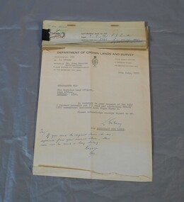
... sales right to occupy Government Four books of stubs. Originally ...Four books of stubs. Originally the books had 20 right to occupy residence area forms. The stubs record the date of issue, the replacing right No., the fee paid, the receipt no. and a signature. only one of the books has the original form attached, two of the books have handwritten notes attached. One has a typewritten letter from a Mr. L. Gibney of the department of Crown lands and survey dated 24th July 1972 addressed to the district land officer, Bendigo. In the letter Mr. Gibney tells the officer in Bendigo that a pad containing 20 unnumbered residence area right forms D. The dates on the stubs are 17/04/1961, 16/04/1971, 07/09/1972, 08/05/1975land sales, right to occupy, government -
 Kew Historical Society Inc
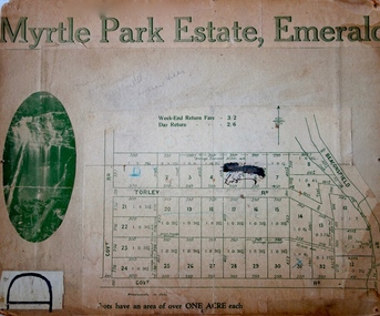
Plan - Subdivision Plan, Myrtle Park Estate, Emerald, 1915
This subdivision plan for the ‘Myrtle Park Estate’ relates to land sales in Emerald, Victoria, rather than to the subdivision of the same name in East Kew (1913-16). The subdivision in Emerald included 32 one-acre lots facing Torley Road, Government Road (now Rawhiti and Wong Hee Roads) Beaconsfield Road (now Old Beaconsfield Road). On the plan, an unnamed creek flows through allotments 8-12 on the east side of the Estate. The photograph of a waterfall and the advertised price of Day Return and Weekend Return Fares provide an indication of who the prospective purchasers were likely to be.subdivision plans - emerald, myrtle park estate, torley road -- emerald (vic.) -
 Kew Historical Society Inc
Plan - Subdivision Plan, J Hurrey, Section 115 in the Parish of Boroondara Near Richmond Bridge, 1853
Despite the plans claims that it is a subdivision near the Richmond Bridge, Section 115 was located at what is now Camberwell Junction. While the plan only lists government roads rather than named streets, the section was located on the east side of Burke Road, stretching up the hill from the current Junction. Research on Trove, conducted by Kerry Fairbank, discovered an advertisement for unsold lots in Section 115 which clarifies the extent and location of subsequent land sales in the original section. The original article can be viewed through the link in the catalogue record. The interesting link to Kew is the reference to James Beavan as the purchaser of lots 14 and 15. The historian Gwen McWilliam has notes that a Mr Beavan changed his name from Bevan. The Bevans were descendants of the Derricks family of Kew. This subdivision plan is the earliest original map or plan in the collection which shows parts of what is now the City of Boroondara, dating from circa 1853. It provides important information for researchers on subsequent subdivisions following the original land sales in [Camberwell] Boroondara. The site, on the east side of Burke Road is a highly-significant and historic site. This is believed to be the only extant copy of the subdivision in public collections.A small plan on parchment listing 28 lots, between one and two acres each, for sale in Section 115 in the Parish of Boroondara, dating from 1853 when the portion was subdivided.Obverse: Lot 16 "Joseph Duval", Lots 14 & 15 "James Beavan". Other annotations (measurements) are unreadable. Reverse: "KH-981 / Section 115 in the Parish of Boroondara / Near Richmond Bridge / 1640T. / J Duval / 14-15 J. Beavanparish of boroondara, subdivision plans - camberwell, section 115 - boroondara, subdivision plans -- camberwell (vic), riverscape road, burke road, camberwell junction -
 Kew Historical Society Inc
Photograph - Studley Park, 1937
Those sections of Studley Park closest to the River Yarra were set aside as parkland in the 1850s. After initial discussions about whether it was a suitable site for a Government House, much of the land was instead gazetted in the 1860s as the location for a new lunatic asylum, to expand overcrowded mental health facilities at the Yarra Bend Asylum on the other side of the river at Fairfield. Those sections of Studley Park bounded by the Yarra River, Studley Park Road, Princess Street and Fellows Street were subdivided and sold at the Crown Land Sales in 1851. Much of this urban area remained open farmland until the twentieth century, apart from mansions, largely located along the main roads.Original, black and white positive print of what is said to represent Studley Park in 1937. If the attribution and date is literally to be understood, then it would appear that the photograph may have been taken from the Kew side of the river looking across to open farmland in the Yarra Bend Park. If the designation of Studley Park is to be understood more loosely, then it might be a view of what is now East Kew, taken from a section of Kilby Road. Inscribed verso: "Studley Park 1937" studley park -- kew (vic.) -
 City of Greater Bendigo - Civic Collection
Administrative record - Land Sales, A. J. Mullet Government Printer et al, 1927
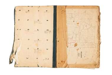
... and newspaper clippings about land sales and auction details pasted ...This type of album was made by agents auctioning and selling land.Large portfolio style album with dark green / black cloth cover bound with three large metal pins. Forty eight pages with twenty seven Department of Lands and Survey maps and newspaper clippings about land sales and auction details pasted in. Index page. Maps have handwritten notes and markings throughout in pencil and pen. Covers the County's of Gunbower and Tatchera. Includes a receipt slip with hand written notes on reverse on William Wallace & Co letterhead. city of bendigo commerce -
 City of Greater Bendigo - Civic Collection
Administrative record - Land Sales, Department of Lands and Survey et al, 1929
This type of album was created by agents auctioning and selling land.Large portfolio style album with green cloth cover bound with three large metal pins. One hundred and then pages with thirty three Department of Lands and Survey maps pasted in. Index page. Maps have handwritten notes and markings throughout in pencil and pen. Covers the Counties of Bendigo, Rodney, Talbot, Gunbower, Gladstone, Tatchera and Karkarooc, Shires of East Loddon and Huntly and Swan Hill District. -
 City of Greater Bendigo - Civic Collection
Administrative record - Land Sales, A. J. Mullet Government Printer, 1927
... on William Wallace & Co letterhead. Administrative record Land Sales ...This type of album was created by agents auctioning and selling land.Large portfolio style album with black cloth cover bound with three large metal pins. Blue marbled pastedown endpapers. Seventy nine pages, seventy five with Department of Lands and Survey maps attached. No index page. Maps have handwritten notes and markings throughout in pencil and pen. Covers the Counties of Bendigo, Rodney, Gladstone and Talbot and Parishes of Kerang, Salisbury, Mandurang and Tarnagulla. Includes a hand written note on William Wallace & Co letterhead. city of bendigo commerce -
![Map, Liquidator's sale, 1896. [Woolpack Estate, Bacchus Marsh]](/media/collectors/5e461d8021ea67224c82f2a1/items/6779ee97032b72846b5995f2/item-media/6779ef33032b72846b599b30/item-fit-380x285.jpg) Bacchus Marsh & District Historical Society
Bacchus Marsh & District Historical SocietyMap, Liquidator's sale, 1896. [Woolpack Estate, Bacchus Marsh]
The Woolpack Estate was an area of land owned by various landowners in the Bacchus Marsh area since the early Colonial period of the 1840s. The area was located on the eastern side of the Bacchus Marsh township about 7 kilometers from the town. The Lerderderg River ran through part of the land and so did the Melbourne to Ballarat Road. The historic Woolpack Inn associated with James Crook was also located on this land. By 1896 150 acres of this land was under the control of liquidators for the Federal Bank of Australasia who instructed that the land be sub-divided and sold in lots by public auction. A successful sale was held on 24 June 1896. Most of the blocks of land were sold for higher than expected prices and most of the buyers were people from the town and district of Bacchus Marsh. The map includes various details about the land which is described on the map as an "important sale of rich alluvial irrigable flat land in the Bacchus Marsh Valley, and other properties". The auction was conducted by the local agents W. Anderson and Bence in conjunction with Pearce Brothers also of Bacchus Marsh.A single page paper map showing a plan of 150 acres of land from the Woolpack Estate to be sold in various lots in June 1896. Also shown on the map are lots for sale at Robinson's Farm on Coimadai Creek and allotments near Bacchus Marsh railway station, including lots on Government Road (East Maddingley Road), View Street and Government Road (Parwan Road). No scale provided. The map is pasted into a bound volume containing 76 maps or plans in total. High resolution digital image stored on BMDHS computer network. land sales bacchus marsh, bacchus marsh victoria maps, woolpack estate bacchus marsh victoria -
 Wodonga & District Historical Society Inc
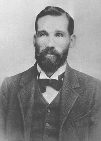
Photograph - Michael "Mick" Mulqueeney Stock Agent, Wodonga
Mick Mulqueeney was born in Kilmore and arrived in Wodonga in 1886, when it was Australia's greatest store cattle market. It was not unusual to see 10,000 cattle sold in a single day. For a few years he spent time overlanding large mobs of cattle from Queensland and the back country of N.S.W He settled in Wodonga and began business as a stock and station agent at Wodonga. He was the Wodonga representative of Edward Trenchard and Co, and other Newmarket stock agents but also conducted auctions on his own account. For several years, he was in partnership with Mr A. L. Wright. Following the retirement of Mr. Wright in 1902, Mick Mulqueeney then joined with Harry H Peck under the trade name of Peck Sons and Mulqueeney. This partnership was dissolved after about 10 years and Mick was bought out by New Zealand Loan. Later he continued in stock and station agency on his own. During this time, he also conducted a very extensive stock forwarding agency where tens of thousands of stock of all classes were shipped owing to the break of gauge from N.S.W, into Victorian trucks and vice versa. He was regarded by stock owners as a genius among stock. Michael also had a sound knowledge of land in the Wodonga district and when the settlement of returned soldiers onto the land was taking place he was appointed valuer of properties being considered by the Repatriation Department. Mick also became a Government stock inspector on the Victorian side of any stock crossing the border. At this time his forwarding agency was carried on by his son, Mr. Jack Mulqueeney. Michael Mulqueeney died on 19th June 1929 and was buried at Yackandandah, VictoriaThis photo is significant because it depicts an important member of the Wodonga community and an vital industry in Wodonga.Two black and white images showing a portrait photo of Michael Mulqueeney and the Mulqueeney family home.michael mulqueeney, stock agents wodonga, livestock sales wodonga -
Linton and District Historical Society Inc
Documents - purchase of land, Purchase of land by David McFadzean, 1872 - Allotment A1A, Township of Linton, Parish of Argyle
The land was purchased by David McFadzean under the 42nd section of the Amending Land Act, 1865. This allowed long-term tenants ("licensees") of government-held land to purchase ("alienate") the land. The allotment is in present-day Jackson Street, Linton.Twelve A4-size photocopies of documents relating to the purchase of an allotment of land - Allotment A1A, measuring 5 acres, 3 roods and 37 perches - within the boundaries of the Township of Linton. First page is headed "SECTION 31, "LAND ACT 1869". Documents include David McFadzean's application to purchase, notes made about the land and the application by officers of the Board of Land and Works, a plan of the allotment, and information about purchase price and fees.allotment a1a township of linton, david mcfadzean, victoria. amending land act 1865, conveyance, land sales, land purchases, documents and records, james beament -
 Dandenong & District Historical Society
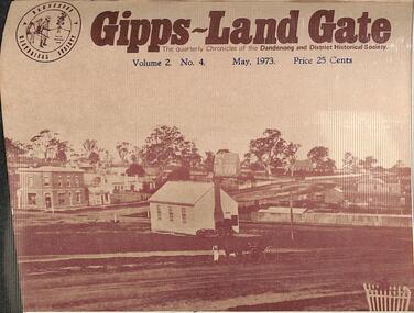
Journal, Dandenong & District Historical Society, Gipps-Land Gate Vol.2 No.4, 1973
An interesting group of Early Dandenong Personalities, Places and EventsA5 size publication of the Gipps-Land Gate, May 1973. 16 pages, featuring an old picture of Dandenong on the cover. Dandenong's First Initiation Into The Ways Of Local Government Delving Into "Laurel Lodge's" Past Some Dandenong Property Sales Turning Back The Pages 75 Years Official Opening of "Laurel Lodge" An interesting group of Early Dandenong Personalities, Places and Eventshotel history, early education in dandenong, interesting milestones -
 Dandenong & District Historical Society
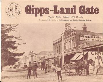
Journal, Dandenong & District Historical Society, Gipps-Land Gate Vol.3 No.1, 1973
An interesting group of Early Dandenong Personalities, Places and EventsA5 size publication of the Gipps-Land Gate, October 1973. 16 pages, featuring an old picture of Dandenong on the cover. Keeping Posted Dandenong Settlers The Orgills 1892 Acrostic Recalls Eraly Names "A forgotten quarter of Dandenong's History" Local Government, 1864 - Roads Board Style Dandenong Property Sales Fifty Years Ago Bush Fire Swept Racecourse - But The Races Went On! "Laurel Lodge" Open Sunday Afternoons A Centenary Film Record An interesting group of Early Dandenong Personalities, Places and Eventshotel history, early education in dandenong, interesting milestones, family histories