Showing 52 items matching "historic precinct"
-
 Buninyong & District Historical Society
Photograph - Original Photograph, Derek Leather, Learmonth St. Town Hall precinct, in 1970, Copy of original photograph made 1970-80
Historic BuildingsB/W original photo, Learmonth St. Town Hall precinct, c 1890, from left 3rd Fire Station, Town Hall with clock tower, brick Butchers shop, Avenue of Honor trees.buninyong, fire station, town hall, whyke's butchers, avenue of honor -
 Buninyong & District Historical Society
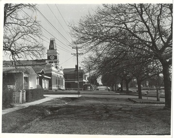
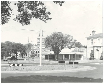
Photograph - Photograph of Original Photograph, Derek Leather, View West up Warrenheip St. Town Hall precinct, 1970's, Copy of original photograph made 1970-80
Historic BuildingsB/W Photo West up Warrenheip St. Town Hall precinct, 1970's, Across roundabout to Town Hall, Shire offices and fire station left, Whykes Butcher shop and Adams Store, and two story Bank to right.buninyong, learmonth st., shops, town hall precinct -
 Buninyong & District Historical Society
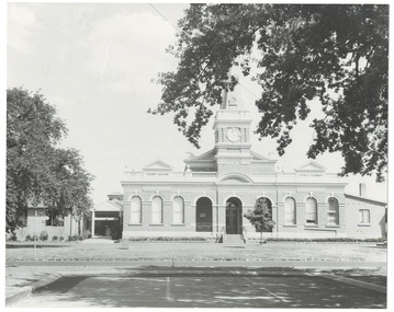
Photograph - Original Photograph, Derek Leather, Town Hall in 1970's, front view, showing part of 1950'2 Shire Offices, Copy of original photograph made 1970-80
Historic BuildingsB/W Photo Town Hall in 1970's, front view, showing part of 1950's Shire Officesbuninyong, learmonth st., town hall precinct -
 City of Ballarat
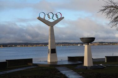
Artwork, other - Public Memorial, Olympic Monument
The Olympic precinct redevelopment was driven by a group of Ballarat Olympians to commemorate 50 years since the 1956 Olympic rowing events on Lake Wendouree. The memorial highlights the values of the Olympic movement and honours Ballarat Olympians by bronze casts of hands or feet. The memorial was constructed by Ballarat builder H. Troon using the Olympic rings as the focal point.The monument is of historic and social significance to the people of BallaratWhite stone monument mounted with Olympic rings"The most important thing in the Olympic Games is not to win but to take part, just as the most important thing in life is not the triumph, but the struggle. The essential thing is not to have conquered, but to have fought well."olympic games, 1956 olympic -
 City of Ballarat
Artwork, other - Public Artwork, Travis Price, Main Road Mural by Travis Price, May 2018
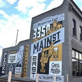
Whilst my main focus for the artwork design was on the Hotels on Main Road, I felt there was an opportunity to tell a broader story of Main Rd and combine/include some interesting pieces of information from many stages of the history of Main Road. Considering that at one point in time there would have been at more than six hotels in this very short section of street….there’s no doubt Main Rd was an epicentre of communication and festivities for the Goldfields of Ballarat. “No matter what luck he had, every miner needed supplies, food and something to entertain him when he was not searching for gold.” Described as being an overcrowded jumble of muddy streets loosely arranged around mining camps...and loud, muddy, colourful and sometimes illicit. I wanted the artwork composition to consist of overlapping images and text to reflect this sense of hustle and bustle. Main Road Mural tells the broader story of the history of Main Road in Ballarat. In 2018, the City of Ballarat commissioned local Ballarat artist Travis Price to create an artwork to align with the Main Road Revitalisation Project and deliver a key component of the storytelling (heritage interpretation) project that spans the length of the shopping precinct. The artwork is featured on a prominent site in the shopping precinct of main road and tells the story of Main Road through depicting key timeline events. Main Road, as its name suggests, was one of the main entries to the mining areas of East Ballarat. It had several names: Main Street before 1858, Plank Road between 1858 and 1868 and Main Road from 1868 onwards. The centre of mining life, it was crowded, prosperous, raucous and dirty. Painted mural on shop wall in Main Road, BallaratBallaarat, Gold Fever, The Royal Standard Hotel, Flood, Boxing Saloon, Plank Road, Kulin Nation, 3350, Election, East, Grog House, The Scandinavian Hotel. Images; Chinese lantern, Pick & Shovel, Miners Licence burning.main road history, ballarat hotels, gold fever, wadawurrung, kulin nation -
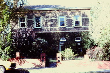
 Whitehorse Historical Society Inc.
Document, Thomas Street Precinct Mitcham, n.d
Statement of historic significance of housing in the Thomas Street area.Statement of historic significance of housing in the Thomas Street area, principally Californian bungalows.Statement of historic significance of housing in the Thomas Street area.thomas street mitcham, city of whitehorse heritage review 2002, californian bungalows -
 Ballarat Heritage Services
Photograph - Photograph - Colour, Clare Gervasoni, Koroit Post Office, 2015, 21/12/2015
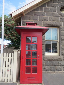
The town borrows its name from the Koroitch Gundidj people who occupied the area prior to European settlement. (https://en.wikipedia.org/wiki/Koroit, accessed 21 December 2016) Koroit was first surveyed as a township in 1847. Around the 1850 the district had the highest population of Irish immigrants in rural Australia. The Koroit Post Office was designed by architect and engineer John Mason of Port Fairy. (Moyne Shire Heritage Study 2006 Stage 2, Volume 2: Environmental History, Prepared for Moyne Shire Council Helen Doyle in association with Context Pty Ltd, 2006.) Rosebrook Bridge, Rosebrook (1853; replaced) Post Office buildings, Bank Street, Port Fairy (c.1857) The author Henry Handel Richardson lived in the Koroit Post Office as a child after her family moved to Koroit in 1878. Remembering Koroit from her youth, the third volume in her The Fortunes of Richard Mahony trilogy is set in the town. When the author was six, her father Walter died in Koroit on 1 August 1879 and was buried at the Koroit cemetery. (https://en.wikipedia.org/wiki/Koroit, accessed 21 December 2016) In 1878 Mary Richardson was appointed postmistress of the Koroit Post Office at a salary of 72 pounds with free quarters, firewood and kerosene. She lived at the back of the Post Office. (From a Green and Pleasant Land by H. McCorkell and P. Yule.) Photographs showing the bluestone Koroit Post Office, phone box and postbox. It is located at 99 Commercial Road, Koroit. "Historic Area Statement of Significance: The significance of Koroit derives from its role as the urban centre of one of the most concentrated Irish Roman Catholic rural districts in Australia, noted for its mixed livestock and cropping argicultural patterns. This is reflected in two separate and distinctive areas in the town - the administrative/commercial area and the church precinct. The administrative and commercial area (focussing on the Boundary-Commercial Road/High Street intersection and the Koroit Hotel) consists of a number of significant public buildings and leads to a street of relatively intact humble shopfronts and kerbline verandahs, visually punctuated by opposing bank facades. The church precinct is dominated by a group of Catholic buildings larger in scale and more complete in range than those in any comparably sized Victorian town." http://vhd.heritagecouncil.vic.gov.au/places/69338#sthash.ELLuSMvg.dpuf, accessed 21 December 2016."koroit, post office, phone box, payphone, bluestone, henry handel richardson, koroit post office -
 Buninyong & District Historical Society
Photograph - Original Photograph, Clive Brooks, 1859 Buninyong Police Residence/Station, former Legal Precinct, Cornish St., from south, 9 Nov. 1991
detail of historic buildingColour photo 1859 Buninyong Police Residence/Station, former Legal Precinct, Cornish St., from southbuninyong, police station, legal precinct, cornish st. -
 Buninyong & District Historical Society
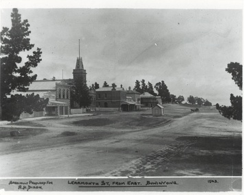
Photograph - Original Photograph, Learmonth St from the east, Town Hall Precinct, early 1900's, 9/11/1991
historic buildingsB/W photograph, Learmonth St from the east, Town Hall Precinct, early 1900's, Refreshment Rooms, Fire Station, Town Hall, Whyke's Butchers, Allan's Store, Bank, Buninyong Inn, toll booth."Specially Produced For A.H. Dixon Learmonth St, from east, Buninyong 1543"buninyong, calf's refreshment rooms, fire station, town hall, whyke's butches, allan store, nab bank, buninyong inn, toll booth -
![EJ Harvey, Motor Engineers, High Street [Kew East], circa 1925](/media/collectors/550653872162f11fb04854aa/items/586f9929d0ce2607f0b81f1a/item-media/586f99e0d0ce2607f0b8546f/item-fit-380x285.jpg) Kew Historical Society Inc
Kew Historical Society IncPhotograph - Photograph [copy], EJ Harvey, Motor Engineers, High Street [Kew East], circa 1925, c. 1925
The building was in High Street, Kew East between Clyde and Oswin Streets. The site is currently (2017) occupied by a canoe retailer.Rare and historic photograph of an early business in the Harp Village shopping precinctGarage - E.J. Harvey, Motor Engineers workshop, High Street, East Kew. The garage was on the corner of Clyde Street.Inscription reverse: "High Street, East Kew - present site of Harvey Phillips Retro Vision[*] shop. Gift of Edna Phillips. Edna loaned KHS the original photo and KHS had it copied." * Note - Harvey Phillips Retravision not Retro Vision].motor engineers (kew), garages (kew), e.j. harvey -
 Kew Historical Society Inc
Slide - 4 Selbourne Road, Kew, 1979
One of a group of slides taken by members of the Society of built heritage in Kew in 1979-80. The selection of subject matter reflects the priorities of the period. The colour of some slides has degraded.The slides represent a snapshot in time of built architecture in Kew, much of which has changed in the forty-plus period since they were created.Colour positive transparency (slide) of 4 Selbourne Road, Kew, the former home of Sir Wilfred Kent-Hughes (1895-1970) who was the State Member for Kew from 1927-1949. Subsequently he was elected to the Federal Parliament as the Member for Chisholm. The two-storey, double fronted, polychrome brick house is within the City of Boroondara's Glenferrie Road Precinct, which includes a number of individually significant architectural designs, the majority of which are Victorian mansions.historic houses -- kew (vic.), 4 selbourne road -- kew (vic.), sir wilfred kent-hughes -
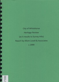 Surrey Hills Historical Society Collection
Book, City of Whitehorse Heritage Review (as it relates to Surrey Hills), 1999
A street by street survey of each of the proposed precincts was undertaken. For each precinct, building fabric was defined in terms of intactness, scale, construction type, architect and predominant eras of construction.A street by street survey of each of the proposed precincts was undertaken. For each precinct, building fabric was defined in terms of intactness, scale, construction type, architect and predominant eras of construction.cultural property, protection of historic sites, heritage overlay precincts, heritage review, building citations -
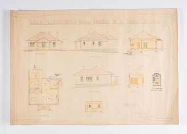 City of Greater Bendigo - Civic Collection
Work on paper - Architectural Drawing, City of Bendigo, Proposed Brick Residence at Bendigo Abbatoirs (sic) for the Bendigo City Council, Not dated
Situated at 47 Lansell Street, Bendigo, the original 1911-12 Charles D'Ebro designed brick Bendigo Municipal Abattoir, comprising twin slaughter and hanging rooms for cattle, sheep and pigs, and two smaller ancillary brick buildings. After the buildings were acquired by the Country Roads Board in 1945, a substantial but sympathetic addition was made to the south-eastern end of the old cattle abattoir. The abattoir is significant for historic, architectural and technical reasons at a state level. as a rare surviving municipal abattoir, and represents the development of hygienic slaughtering through municipal regulations, thus improving standards of public health in Victoria. It is historically significant to the City of Greater Bendigo as a key to the primary production industry that centred on this precinct from the 1860s to the mid 1990s; they are an important surviving component of one of the largest regional livestock markets in Victoria. D'Ebro was critically influential in the development of industrial and in particular meat processing buildings, designing major freezing works and abattoirs throughout Victoria and Australia.(Source, National Trust Database). The Bendigo facility finally closed in 1945, when all slaughtering for local consumption passed to a joint export and local slaughtering facility at the Bendigo Inland Meat Authority. Ink, pen, pencil and watercolour architectural drawing for the proposed brick residence at Bendigo abattoirs. Proposed Brick Residence at Bendigo Abbatoirs (sic) For The Bendigo City Council. / Front Elevation / Easter Elevation / Section A. D. / Ground Plan / Wester Elevation / Section C.D. / Section I. P. ? Existing Building to be / Converted into Laundry ? Scale 1/8" to 1 FT / Geo. Austen Architect / Commonwealth Bank Chambers / Bendigocity of greater bendigo commerce, charles d'ebro -
City of Kingston
Photograph - Colour, 6 March 1993
Edithvale is a suburb in the City of Kingston. It is located between Aspendale and Chelsea on the Port Phillip Bay and built within remnant areas of the Carrum Carrum swamp. The foreshore precinct comprises a wide sandy beach, with low sand dunes and numerous historic boat sheds. The suburb consists of older style dwellings and former holiday houses, combined with mid-century housing and newer homes. The large blocks are increasingly subdivided and the existing dwellings demolished to accommodate units and townhouses, thus changing the landscape of the area and reducing the tree canopy.The beachside suburb of Edithvale was previously part of the extensive Carrum Carrum Swamp. The area was once a source of fish and eels for the Mayone-Bulluk clan of the Bunurong people. Over time the area was drained and predominantly devoted to dairy farming and holiday houses. The farms were gradually sold and subdivided with a large number of homes built after World War II and in the 1960s. Edithvale is mainly residential with a shopping strip along Nepean Highway but little significant industry was ever established in the area apart from a plaster works and confectionary factory, both now closed.Laminated aerial colour photograph of Edithvale as viewed from Alexandra Avenue in the north to Ella Grove Chelsea/Edithvale in the south. regents Park Aspendale can be seen in the top left. The area is built-up with residential housing and facilities including Edithvale Primary School, numerous churches and the Edithvale Railway station. Large sections depict the remnant Carrum Carrum swamp. Edithvale Common and the former "Duck Inn" (Melbourne Water/Friends of Edithvale Seaford Wetlands) can be seen. Edithvale Recreational reserve, the valodrome and Edithvale Public Golf Course are prominent. The image shows vacant land in the area now known as Aspendale Gardens and the newer residential section of Chelsea Heights is not developed. A bike path has been established to cover the secondary drain. The Golf Links Court residential development located off Hughes Avenue is a large vacant block.Black type on white adhesive label: 6-3-93 Black type on white adhesive label: 25/9211, 6/3/93, 11.20 am Black type on white adhesive label: 9211 Yellow circular adhesive sticker Black pencil: 9211 6-3-93 arrow pointing Nedthvale, carrum carrum swamp, aspendale, chelsea -
City of Kingston
Photograph - Colour, Circa 1993
Edithvale is a suburb in the City of Kingston. It is located between Aspendale and Chelsea on the Port Phillip Bay and built within remnant areas of the Carrum Carrum swamp. The foreshore precinct comprises a wide sandy beach, with low sand dunes and numerous historic boat sheds. The suburb consists of older style dwellings and former holiday houses, combined with mid-century housing and newer homes. The large blocks are increasingly subdivided and the existing dwellings demolished to accommodate units and townhouses, thus changing the landscape of the area and reducing the tree canopy.The beachside suburb of Edithvale was previously part of the extensive Carrum Carrum Swamp. The area was once a source of fish and eels for the Mayone-Bulluk clan of the Bunurong people. Over time the area was drained and predominantly devoted to dairy farming and holiday houses. The farms were gradually sold and subdivided with a large number of homes built after World War II and in the 1960s. Edithvale is mainly residential with a shopping strip along Nepean Highway but little significant industry was ever established in the area apart from a plaster works and confectionary factory, both now closed.Aerial colour photograph of Edithvale as viewed from Alexandra Avenue in the north to Ella Grove Chelsea/Edithvale in the south. The area is built-up with residential housing and facilities including Edithvale Primary School, numerous churches and the Edithvale Railway station. Large sections depict the remnant Carrum Carrum swamp. Edithvale Common and the former "Duck Inn" (Melbourne Water/Friends of Edithvale Seaford Wetlands) can be seen. Edithvale Recreational reserve, the velodrome and Edithvale Public Golf Course are prominent. The image shows vacant land in the area now known as Aspendale Gardens and the newer residential section of Chelsea Heights is not developed. A bike path has been established to cover the secondary drain. The Golf Links Court residential development located off Hughes Avenue is a large vacant block.Yellow circular adhesive sticker on plastic Black ink (marker): * (asterisk) Black type on white adhesive sticker: P000108edithvale, aspendale, chelsea, carrum carrum swamp -
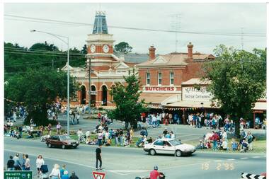 Buninyong & District Historical Society
Photograph - Colour photograph, Buninyong Gold King Festival Feb.Feb.1995, view of Town Hall Precinct, Buninyong Gold King Festival Feb.Feb.1995, view of Town Hall Precinct
historic, mining, De Soza, Gold KingColour photo, Buninyong Gold King Festival Feb.Feb.1995, view of Town Hall Precinctmining, gold king, de soza -
 Eltham District Historical Society Inc
Document - Binder, Eltham Justice Precinct, 1969-2020
... Precinct 32. Newspaper article: Historic Eltham Courthouse reopens... Precinct 32. Newspaper article: Historic Eltham Courthouse reopens ...EDHS_04863 - Binder: Eltham Justice Precinct 1. Courthouse 1. Eltham Courthouse interesting facts 2. Plan and elevation drawings 3. Other courthouse plans and fittings 1880s – Brunswick, Maffra, Dunolly , Sunbury, Landsborough and Wodonga 4. Newspaper articles: i. ELTHAM POLICE COURT. (1892, April 1). Evelyn Observer, and South and East Bourke Record (Vic. : 1882 - 1902), p. 2 (MORNING.). Retrieved July 5, 2022, from http://nla.gov.au/nla.news-article60667022 ii. BREAKING A PUBLICAN'S LEG. (1900, July 13). Evelyn Observer, and South and East Bourke Record (Vic. : 1882 - 1902), p. 2 (MORNING.). Retrieved July 5, 2022, from http://nla.gov.au/nla.news-article60688367 iii. ELTHAM COURT. (1901, March 1). Mercury and Weekly Courier (Vic. : 1878 - 1903), p. 3. Retrieved July 5, 2022, from http://nla.gov.au/nla.news-article58578953 iv. ANNIE CHASES A TINKER. (1902, October 3). Evelyn Observer, and South and East Bourke Record (Vic. : 1882 - 1902), p. 2 (MORNING.). Retrieved July 5, 2022, from http://nla.gov.au/nla.news-article64029968 v. ELTHAM POLICE COURT. (1927, May 6). Advertiser (Hurstbridge, Vic. : 1922 - 1939), p. 4 (AFTERNOON). Retrieved July 5, 2022, from http://nla.gov.au/nla.news-article57754748 vi. ELTHAM POLICE COURT. (1927, May 20). Advertiser (Hurstbridge, Vic. : 1922 - 1939), p. 3 (AFTERNOON). Retrieved July 5, 2022, from http://nla.gov.au/nla.news-article57754814 vii. Eltham Police Court (1931, January 9). Advertiser (Hurstbridge, Vic. : 1922 - 1939), p. 4. Retrieved July 5, 2022, from http://nla.gov.au/nla.news-article56734073 viii. Repairs to Eltham Police Station, The Advertiser (1929, May 24). Advertiser (Hurstbridge, Vic. : 1922 - 1939), p. 2 (AFTERNOON.). Retrieved July 5, 2022, from http://nla.gov.au/nla.news-article57759907 ix. ELTHAM COURT. (1929, August 2). Advertiser (Hurstbridge, Vic. : 1922 - 1939), p. 4 (AFTERNOON.). Retrieved July 5, 2022, from http://nla.gov.au/nla.news-article57760345 x. See also Trove list https://trove.nla.gov.au/list/116634 5. Letter: Shire of Eltham Historical Society to Shire of Eltham, 1 July 1969 regarding potential replacement of Eltham Courthouse and the building’s historical significance and acknowledgement 10 July 1969 6. Letter: Shire of Eltham Historical Society to Law Department, 26 May 1972, re preservation of Eltham Courthouse and potential classification and acknowledgement 7 June 1972 7. Newspaper article: Strangers around, so Eltham sought protection by Marguerite Marshall, Diamond Valley News, Tuesday, April 6, 1982, p2 (On reverse side, Top job for our Pauline, p1) 8. Eltham Courthouse Colour Scheme, Public Works Department, 10 September 1983 9. Newspaper article: Eltham Courthouse under threat of closure by Helen Gillman, Diamond Valley News, October 16, 1984 10. Newspaper article: Courthouse to close by Helen Gillman, Diamond Valley News, Tuesday, November 20, 1984, p1 (also on p2 an article about Diamond Valley Shire festivities for the State’s 150th) 11. We will keep your court – Kennett, Diamond Valley News (probable), c.Dec. 1984 12. Letter: Shire of Eltham to Shire of Eltham Historical Society, 15 March 1985, regarding potential for use of building as a museum and reply dated 17 April 1985 regarding Society’s interest in use of the building 13. Letter: Department of Conservation Forests & Lands to Shire of Eltham, August 1987, regarding expressions of interest in the building and letter from Shire (18 August 1987) to Society advising of same 14. Letter: Department of Conservation Forests & Lands to Shire of Eltham, 30 March 1988, advising Courthouse to be used by Eltham Youth Resources Centre and the rear section by other community groups. Noted that the historical society was suggested by Council as a future user of the adjoining police residence when Council first sought management of the building and that should be investigated. Includes Schedule of Repair and Maintenance Work (4 pages), Existing Conditions Survey 30/7/1987 (6 pages) and 1 page plan view diagram 15. Memo: Historic Places Section to Eltham Youth Resource Centre re paint analysis of Courthouse, 17/5/1988, (6 pages) 16. Newspaper article: Courthouse renovation by Jodie Haythorne, Diamond Valley News, November 23, 1992 17. National Trust of Australia Registration (classified 20 Oct 1977), printed March 2000 18. Letter: Heritage Victoria 28 Feb 2002 regarding the replacement of the Courthouse Stand (Witness Box) 19. Article: There’s still order in this stately court house, Eltham Shire (magazine), date unk., p22-23 20. Eltham Court House, Statement of Significance, Heritage Victoria Register, printed Nov 2004 21. Eltham 1860 Former Court House 730 Main Road Eltham, collated by Eltham District Historical Society Incorporated 2005 (4 pages) 22. Book Extract: Eltham, Historical Court Houses of Victoria by Michael Challinger, Palisade Press, 2001 23. Newspaper article: Courthouse rich with history by Harry Gilham, Nillumbik Mail, c.2001 (see also EDHS_03333) 24. Notes on history of site from Crown Reserve File Rs 12128, Municipal Buildings (Local Community Welfare Reserve) at Eltham, Department of Sustainability and Environment, April 2005 (4 pages) 25. Newspaper article: Historic building upgrade, Diamond Valley Leader, August 3, 2005, p17 26. Newspaper article: Courthouse regeneration secures boost, Valley Weekly, August 10, 2005 with picture of Harry Gilham, Steve Herbert and Greg Johnson 27. Newspaper article: Poets are summonsed, Diamond Valley Leader February 22, 2006, p37 features picture of Helen Lucas at the Eltham Courthouse 28. Newspaper article: Sharing a love of legalities, Diamond Valley Leader, March 1, 2006, p7 features a picture of Rob Hulls and Steve Herbert talking to students in the courthouse 29. Newspaper advertisement: Nillumbik Tender No. 2021-33, Building Restoration Works, Old Eltham Courthouse, The Age, November 7, 2020 30. Form: Police Officer’s Return To A Warrant Of Distress 31. Handwritten notes: three pages listing all 48 of the pigeon hole form listings in the cabinet in the courthouse 32. Newspaper article: Historic Eltham Courthouse reopens, Manningham and Nillumbik Bulletin, April 2022, p22 2. Police Quarters 1. 1971 Surveyors Plan of 728 Main Road and the Adjoining Courthouse 2. Letter: Shire of Eltham to Shire of Eltham Historical Society, 5 June 1981, requesting the society give consideration to the suitability of the existing buildings (former Vermin and Noxious Weeds Office, Department of Crown Lands and Survey) for historical purposes such as a museum 3. Minutes: Shire of Eltham Historical Society Committee Meeting, 10 June 1981 (2 pages) includes reference to possible use of building as a museum (also reference to Bills Horse trough to be retained) 4. Extract from Victoria Police Gazette 1930 with details of building and site 5. Newspaper article: Cubby haven, Diamond Valley News, October 28, 1991 about replica Police Station with picture of replica along with Monika Roitinger and Garry Bartlett outside the Police Station 6. Environment office up for sale? Mountain Views, Monday, June 12, 1995 (Nillumbik Shire Council proposing to sell property. Did not proceed as ownership held by the State of Victoria) 7. Extract from National Trust February 1998 edition, “Police Rescue” which states Heidelberg and Eltham Police Residences are the oldest known Police Residences in the Melbourne Metropolitan district 8. Newspaper article: The first police office by Harry Gilham, Nillumbik Mail, December 13, 2000 (also photocopy with notations on picture identifying buildings and Harry’s typed draft) 9. Fax Memo: Victoria Police List of Officers in Charge, Eltham Police Station, 1857-1991 onward, 21 Jan 2003 10. Former Police Quarters, Statement of Significance, Heritage Victoria Register, printed Nov 2004 11. Eltham 1860 Former Police Quarters 728 Main Road Eltham, collated by Eltham District Historical Society Incorporated 2005 (5 pages) 12. Report: Eltham District Historical Society to Living and Learning Nillumbik, 14 April 2010 regarding the poor state of condition of the former Police Residence 13. Photocopy of three photos of the former Police Residence, former Police Station (relocated to rear of site) and Stables, October 18, 1991 3. Lockup 1. Newspaper article: Heritage permit bid, Diamond Valley News, January 17, 2001 (also article “Eltham library tops”) includes picture of lockup located in Youth Road 2. Newspaper article: Old lockup in new site, Diamond Valley Leader, March 21, 2001, p15. Includes picture of Harry Gilham with lockup at justice Precinct 3. Letter: Victoria Police to Eltham District Historical Society, 20 March 1991 including laser print photo of lockup in 1963 at 23 Pryor Street 4. Fax: Graham Clark, Associated Crane Trucks Pty Ltd, 833 Main Road Hurstbridge; Quote 26.2.99 for $1,080 to move lockup from Youth Road to 728 Main Road 4. Local History Centre 1. Victoria Government Gazette: Photocopy, No. 165, Tuesday, December 7, 1858, establishment of a Court of Petty Sessions at Eltham, 7 December 1858 2. Victoria Government Gazette: Photocopy, September 16, 1859, contract issued for Police buildings at Eltham to Langridge and Co., McCarter, Baillie, Nicol and Co, Chadley, Amos and Co., Cameron, Payne, £1,150.7.0 3. Victoria Government Gazette: Photocopy, October 2, 1860, contract issued for Court of Petty Sessions at Eltham to James Duncan, £600 4. President’s Report, Eltham District Historical Society, Annual General Meeting, Wednesday, March 11, 1998 – covers the establishment of the Local History Centre and new home for the Society 5. Extract for EDHS Newsletter July 1998 – Eltham Local History Centre – Official Opening 6. Unveiling of 728 Street Sign, Speech notes by Cr Dianne Bullen, December 2000, includes invoice from John Sharp Signs Pty Ltd, 24/10/2000 and planning approval drawing dated 24/3/1999 reproduced in Newsletter No. 135 November 2000 7. Letter: Eltham District Historical Society to Living and Learning Centre, undated draft regarding being a member of the committee reviewing the development of the site 8. Notes from Rod Grant re funding of site development under the Community Jobs Program 9. Letter: Eltham District Historical Society to Nillumbik Living and Learning, 28 October 2004 re inclusion of the Society in enhancing the site under the Community Jobs Program 10. Letter: Department of Sustainability and Environment to Eltham District Historical Society, 28 February 2005 re preparing draft Conservation Plan and copy of cover letter in response 2 April 2005 11. Levels and Layout Plan, Nillumbik Shire Council, September 2005, AO copy 12. Letter: Department of Sustainability and Environment to Eltham District Historical Society, 12 September 2005 re Eltham Justice Precinct Conservation Management Plan 13. Letter: Living and Learning Nillumbik, 2 February 2006 to Eltham District Historical Society re forming a Committee to advise on the use, maintenance, management and preservation of the Justice Precinct 14. Minutes: Meeting of a Task group to explore the establishment of a Committee to manage the Eltham Justice Precinct, 20 December 2005 (with hand written notes) 15. President’s notes (EDHS), General Meeting item, 11 May 2006 pertaining to use and condition of the Eltham Justice Precinct 16. Paint estimates, Old Eltham Court House, undated 17. Notes from meeting 26 September (2006), Eltham Justice Precinct Committee 18. Notes from meeting 27 November (2006), Eltham Justice Precinct Committee 19. Terms of Reference for the Eltham Justice Precinct Committee, Draft for Living and Learning Committee Meeting 24 Jan 2007 (4 pages) 20. Newspaper article: Panel set up, Diamond Valley Leader, 7 March 2007 21. Minutes: Meeting of Eltham Justice Precinct Subcommittee, 10 May 2007 22. Minutes: Meeting of Eltham Justice Precinct Subcommittee, 5 July 2007 23. Minutes: Meeting of Eltham Justice Precinct Subcommittee, 11 October 2007 24. Minutes: Meeting of Eltham Justice Precinct Subcommittee, 7 February 2008 25. Minutes: Meeting of Eltham Justice Precinct Subcommittee, 10 April 2008 26. Minutes: Meeting of Eltham Justice Precinct Subcommittee, 14 August 2008 27. Letter: EDHS (Sue Law) to Living and Learning, 6 September 2008 re proposed signage 28. Agenda: Meeting of Eltham Justice Precinct Subcommittee, 16 October 2008 29. Suggested guidelines for use of the Court House for exhibitions 30. Handwritten note re Ken Eckersal and Uniting Church of possible donation of church organ for sale, proceeds to be used for activities at the Justice precinct 31. One page typed notes on each of the buildings in the Eltham Justice Precinct 32. Newspaper article: Historic Eltham Courthouse reopens, Manningham and Nillumbik Bulletin, April 2022, p22 5. Miscellaneous 1. Photocopy from Pioneers & Painters (2 pages) covering the establishment of Police and Court of Petty Sessions at Eltham 2. Photocopy of photo looking northeast across Little Eltham buildings c.1910 with notes 3. Photocopy of J.H Clarke photo looking up Maria Street from near Dalton Street with notes identifying precinct buildings 4. Photocopy of photo of Court House and Police Quarters with cow outside from Heather Jenkins scrapbook with notes identifying buildings 5. Sketch and notes with dimensions for blue stone lockup including other miscellaneous handwritten notes 6. Unidentified heritage review details of Justice Precinct (c.2004) 7. Hand written notes of telephone conversation held with Dennis McKay (6 May 1997) re Council use of site 8. Flyer: Victoria Police Historical Unit 9. Photocopy of thumbnail images of various Justice Precincts (not identified) 10. Email correspondence, 4 and 10 January 2008; J. Connor to Council and Councillors pertaining to proposed new toilet facilities at rear of Courthouse annexe. Two ring lever arch binder, white with various photocopies, printouts, newspaper clippingsHG Folders 15/52/59 integratedharry gilham collection, eltham courthouse, eltham justice precinct, eltham police residence, lockup, eltham community festival, eltham festival, eltham, heritage assessment, police residence -
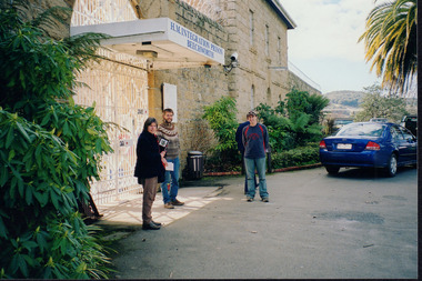 Wooragee Landcare Group
Photograph, 2004
This photo was taken in 2004 and pictures Luke Bailey and Glen Scholfield, the Wooragee Landcare Group coordinator, outside Beechworth Prison. This was the last year Wooragee Landcare Group met with Beechworth Prison Farm and Industry Managers at the prison itself, where they discussed weed and rabbit control on the prison's 'Rockery' block. The weed and rabbit controls that were explored in this event aimed to educate people on how to manage common pests in the Wooragee landscape and improve the appearance of the Beechworth Prison. The Beechworth prison itself is significant as it was built between 1859 and 1864 and is designed using a radiating 'panopticon' method which had proved an efficient, cost-effective design for easy surveillance of prisoners by allowing guards to watch over a large area from a central observation point. The prison is historically significant for its association with the early development of Beechworth as the government administrative centre of north-eastern Victoria. It is part of a major precinct of public buildings and has links to numerous other places in Beechworth which used granite quarried and broken at the prison by male inmates. It is also significant for its associations with the bushranger Ned Kelly and the Kelly storyThe photo holds significance due to the social and educational context the image holds in representing the events Wooragee Landcare Group held in order to educate the public. The photograph also exemplifies the historic significance of the area due to the Beechworth Prison's relation to important historical eras and events.Landscape coloured photograph printed on gloss paperReverse: WAN NA E0NA0N2. NN1- 1 2906 / [PRINTED] (No.15) / 870wooragee, wooragee landcare, wooragee landcare group, beechworth prison, h.m beechworth prison, beechwoth gaol, ned kelly, greg johnson, agriculture victoria, department of primary industries, dpi -
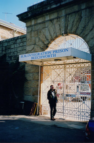 Wooragee Landcare Group
Photograph, 2004
This photo was taken in 2004 and pictures Greg Johnson, who worked at Agriculture Victoria (formerly known as the Department of Primary Industries, DPI), outside Beechworth Prison. This was the last year Wooragee Landcare Group met with Beechworth Prison Farm and Industry Managers at the prison itself, where they discussed weed and rabbit control on the prison's 'Rockery' block. The weed and rabbit controls that were explored in this event aimed to educate people on how to manage common pests in the Wooragee landscape and improve the appearance of the Beechworth Prison. The Beechworth prison itself is significant as it was built between 1859 and 1864 and is designed using a radiating 'panopticon' method which had proved an efficient, cost-effective design for easy surveillance of prisoners by allowing guards to watch over a large area from a central observation point. The prison is historically significant for its association with the early development of Beechworth as the government administrative centre of north-eastern Victoria. It is part of a major precinct of public buildings and has links to numerous other places in Beechworth which used granite quarried and broken at the prison by male inmates. It is also significant for its associations with the bushranger Ned Kelly and the Kelly storyThe photo holds significance due to the social and educational context the image holds in representing the events Wooragee Landcare Group held in order to educate the public. The photograph also exemplifies the historic significance of the area due to the Beechworth Prison's relation to important historical eras and events.Portrait coloured photograph printed on gloss paperReverse: WAN NA E0NA0N2. NNN- 3 2906 / [PRINTED] (No.13) / 868wooragee, wooragee landcare, wooragee landcare group, beechworth prison, h.m beechworth prison, beechwoth gaol, ned kelly, greg johnson, agriculture victoria, department of primary industries, dpi -
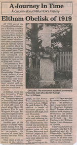 Eltham District Historical Society Inc
Folder, Eltham Obelisk (later Cenotaph), 1918-2018
The Eltham Obelisk was originally located at the corner of Bridge and Main Roads in 1919. In 1943 (WW2) the local community commenced plans to establish the Eltham War Memorial, a living memorial to benefit the children as opposed to a one in stone as per the obelisk. The Eltham War Memorial Trust was established in 1945. In 1947 the Trust intended for the Obelisk to be relocated from Bridge Street and Main Road to the Garden of Remembrance which was planned as part of the Baby Health Centre which was to be the first of three buildings of the Eltham War Memorial to be built in 1951. In 1951 the Eltham RSL was invited to be represented on the Eltham War Memorial Trust. Around this time, with pending roadworks, the obelisk was relocated to the front garden of the Eltham RSL sub branch on Main Road for safe keeping. In 2007, a suggestion was proposed by Harry Gilham (President, EDHS) to John Cohen (ERSL) to claim a special site along with the historic Shillinglaw trees on the now vacant former Eltham Shire Office site adjacent to the Eltham War Memorial precinct for relocation of the obelisk. In 2010 following the financial collapse and sale of the Eltham RSL Sub-Branch property and amalgamation with the Montmorency Eltham RSL sub-branch, the location of the obelisk was again in immediate jepoardy and in conjunction with Nillumbik Shire Council, the obelisk was relocated in front of the Eltham War Memorial buildings in preparation for the Dawn Service on Anzac Day 2012. Contents: Newspaper article: Eltham Obelisk of 1919, Harry Gilham, August 2000 as well as draft submitted dated 22 Aug 2000 Newspaper article: Eltham, The Advertiser 15 Nov 1918 and 18 Nov 1918 Newspaper article: An Obelisk at Eltham, The Advertiser, 11 Jul 1919 Newspaper advertisement: Unveiling of Obelisk at Eltham, The Advertiser, 1 Aug 1919 Newspaper article: Eltham Soldiers’ Memorial; Unveiled by Sir William Irvine, The Argus, Monday, 4 Aug 1919, p8 Newspaper article: Eltham Memorial to Fallen Soldiers, Diamond Creek Valley Advocate, 8 Aug 1919 Newspaper article: Memorial to the Fallen; Unveiled at Eltham, The Age, Monday, 4th August 1919 Newspaper article: Programme - Presentation of German Machine Gun at the Obelisk, Eltham on Sunday, 8th August, 1920, at 3.30 P.M. Newspaper article: article about presentation of a war trophy, a heavy machine gun placed beside obelisk, The Advertiser, 13 Aug 1920 Newspaper article: Eltham: ANZAC Services, The Advertiser, Friday, May 2, 1924 Newspaper article: Eltham War Memorial, The Advertiser, Oct 26, 1928 Handwritten note from Harry Gilham (President EDHS) to John Cohen (ERSL) regarding history of Eltham RSL site and 1947 newspaper article "Eltham War Memorial Trust "Garden of Remembrance" referencing relocation of Obelisk to the proposed Garden of Remembrance at the Baby Health Centre (Eltham War Memorial). Officers' reports, 11.113/10 Relocation of Eltham RSL Cenotaph, Nillumbik Shire Council Ordinary Meeting, 21 December 2010 Email Correspondence: EDHS President to NSC General Manager Community and Leisure re RSL Obelisk (Cenotaph) proposed relocation, 24 May 2011 Newsletter Extract: Eltham RSL and War Memorial, EDHS Newsletter 14 Sep 2011 Officers' reports, OCM.091/11 Interim Relocation site for the Eltham Cenotaph, Nillumbik Shire Council Ordinary Meeting, 23 August 2011 Officers' reports, OCM.004/121 Interim Relocation of the Eltham Cenotaph, Nillumbik Shire Council Ordinary Meeting, 31 January 2012 (includes Funding agreement between NSC and Montmorency-Eltham RSL Sub-branch Inc) Newspaper article: Move war memorial: RSL, c.2011 Newspaper article: Memorial move lags, Diamond Valley Leader, 1 February 2012 Newspaper article: New dawn for tribute, Diamond Valley Leader ca April 2012 Open letter to the residents of Eltham and Montmorency and copies of drafts by the Montmorency Eltham RSL, no date and final version published in Diamond Valley New 21 March 2012 and Banyule & Nillumbik Weekly, 27 March, 2012 Newspaper article: RSL site nets $1.8m, Diamond Valley Leader, 9 May 2012 Newspaper article: Memorial Moved, Banyule/Nillumbik Weekly, 10 April 2012 Newspaper article: Eltham cenotaph move goes 'like clockwork', Diamond Valley Leader, 11 April 2012 Advertisement, Program for Eltham Dawn Service, Diamond Valley Leader, April 2012 Newspaper photo: Veterans (l-r) Alan Field, Max Lowerson and John Cohen will join piper David Cretney to commemorate fallen Diggers, 2012 (standing beside relocated obelisk in front of the Eltham War Memorial complex) Program for Montmorency Anzac Day March 2012 (incomplete, some pages duplicated, some pages upside down). Newspaper article: Plan to expand memorial, Diamond Valley Leader, Sep. 2004, p5 Newspaper article: Names renewal, thanks to Barry, Diamond Valley Leader, 18 Apr 2007, p3 with picture featuring Eltham RSL president John Haines and Gwen Rosewall Letter: EDHS President to Manager Community Participation, Learning and Culture, Nillumbik Shire Council regarding a proposal by the Montmorency-Eltham RSL Sub-branch to expand the area occupied by the relocated obelisk further into the Eltham War Memorial Garden of Remembrance, 18 Aug 2014 Notices of Motion, NOM.001/14 pertaining to memorials Advisory Committee and Montmorency-Eltham RSL to upgrade the Eltham War Memorial site in time for ANZAC Day 2015, Nillumbik Shire Council Ordinary Meeting, 26 August 2014 Agenda: User Groups and Stakeholders Meeting, Proposed Extension to Memorial Terrace, 11 September 2014 EDHS presentation to NSC Policy and Services meeting 9 September 2014 regarding the Montmorency-Eltham RSL proposal to expand/upgrade the Eltham War Memorial Policy and Services reports, PSD.034/14 Eltham War Memorial Building Precinct - Proposed Extension to Memorial Terrace, Nillumbik Shire Council Ordinary Meeting, 9 September 2014 Email (copy): President EDHS re Eltham War Memorial Complex, Main Road, Eltham, 15 Sep 2014 requesting Nillumbik Shire Council place a Heritage Overlay upon the Eltham War Memorial Complex Media Release: Support for cenotaph expansion, Nillumbik Shire Council, Sep 2014 Newspaper article: Council defers RSL war memorial upgrade to see consultation, Diamond Valley News, 17 Sep 2014 Letter (copy): Harry Gilham, Eltham to local press and others, 20 Sep 2014 protesting attempts by the RSL to further expand upon the area already ceded from the Eltham War Memorial for the relocated WW1 obelisk and alter the original vision for an Eltham War Memorial complex. Letter: Alan Field, President, The Eltham Veterans War Memorial Preservation Society Inc. to CEO and Councillors, Nillumbik Shire Council protesting at perceived injustices and ‘veteran bashing’ regarding their previous efforts to relocate ‘their Obelisk and Cenotaph’ to the Eltham War Memorial complex and their frustration in their attempts to further expand upon the Memorial Terrace. Areas of letter are highlighted with handwritten markups and notes. Also notes on loose card and paper with definitions of Memorial, Obelisk, Cenotaph, commentary on establishment of Eltham War Memorial, The Eltham War Memorial Trust and RSL involvement and current actions by RSL in respect to claims in the letter (written by Harry Gilham ?). Policy and Services reports, PS.038/14 Eltham War Memorial Building Precinct - proposed extension to the Eltham Cenotaph Terrace, Nillumbik Shire Council Policy and Services Committee Meeting, 14 October 2014 Newspaper article: Centenary dawn service moves to Petrie Park, Diamond Valley Leader, 22 Oct 2014 Newspaper article: Upset over upgrade; war memorial revamp plans get culled, Diamond Valley Leader, 29 Oct 2014 Newspaper article: Memories of our heroes, Diamond Valley Leader, 25 Apr 2018 – also Veteran saluted, featuring article on Army veteran, Glen Ferrarotto. Handwritten notes in pencil (2 pages) by Harry Gilham, Items form the Eltham and Whittlesea Shires The Advertiser newspaper 7 June 1918 - 1919 providing a summary of the formation of the Peace Celebration Committee leading to the establishment of the Avenue of Honour and the Eltham Obelisk Newspaper article: Obelisk honors their memory, Diamond Valley News, March 30, 1971, p11eltham cenotaph, nillumbik shire council, eltham war memorial, montmorency eltham rsl sub-branch, dawn service, cenotaph, eltham rsl sub-branch, eltham war memorial trust, garden of remembrance, harry gilham collection, john cohen, obelisk, remembrance garden, shillinglaw trees, german machine gun, war memorial, war trophy -
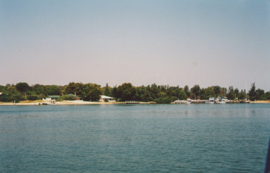 Lakes Entrance Historical Society
Photograph - New Works precinct Lakes Entrance Victoria 2010, M Holding, 2010 c
Colour photograph of cottages and jetties at New Works precinct Lakes Entrance Victoriajetties, topography, ships and shipping, historic houses -
Moorabbin Air Museum
Document (item) - Cole Street Conservation Precinct Married Quarters of Historic Significance at Point Cook RAAF Base Victoria, Steve and Susan Campbell-Wright
... Cole Street Conservation Precinct Married Quarters of... Conservation Precinct Married Quarters of Historic Significance ...