Showing 35 items
matching isabella roberts
-
 Warrnambool and District Historical Society Inc.
Document (item) - Allansford land purchase document, Land purchase document, 1864
... Mrs isabella McQueen Bot. of Robert Gregory As agent for J... isabella McQueen Bot. of Robert Gregory As agent for J M Allan Esq ...This paper contains details of the purchase of Lot 11 in the Township of Allansford in 1864. The purchaser, Isabella McQueen, was born in Scotland in 1814, married Alexander McQueen in 1850 and with her family migrated to Australia in 1854. After her husband's death in 1860 Isabella purchased the land in Frank Street, Allansford in 1864 and lived in a house there with family members until her death in 1895. She had purchased the land, via an agent, from John Allan who with his brothers were the pioneer European settlers in the Allansford area. John Allan had created the township of Allansford in the mid 1850s by sub-dividing the land he owned there. John Allan moved to the Gippsland area late in 1864. This piece of paper is most significant as it is an original record of an early transaction in the history of Allansford, a town now part of Warrnambool City.Mrs isabella McQueen Bot. of Robert Gregory As agent for J M Allan Esq. Lot no. 11 as marked and described on the Plan of Subdivision of the Township of Allansford. For which I have received the um of five pounds Stg. being the purchase money of same. Robert Gregory 21st October 1864allansford history, john allan, isabella mcqueen -
 Linton and District Historical Society Inc
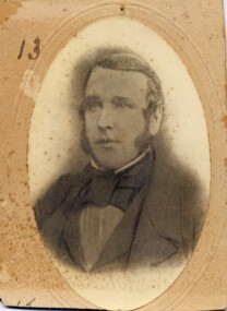
Photograph, John McDonagh
Irishman John McDonagh and his wife Martha, nee Mathews, arrived at Port Phillip on the ship 'Oliver Lang' in August 1855. They brought with them their first three children: Martha, Jane and Robert, and also two of John McDonagh's nieces: Jane and Isabella McDonagh, whose parents had died in Ireland. The McDonaghs had five more children in Australia. They lived at Linton from the mid-1860s. In the Ballarat Star [newspaper] in 1867, John McDonagh was described as a "sheep and cattle dealer". He was a member of the Woady Yaloak Roads Board, and later a member of the Council of the Shire of Grenville. John McDonagh died at Linton in 1871. An inquest into his sudden and unexpected death (copy in McDonagh file) concluded he died of apoplexy (= stroke). Part of Old Lintonian Collection ; No. 13.Sepia photograph."John McDonagh"john mcdonagh, old lintonian collection -
 Linton and District Historical Society Inc
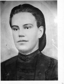
Photograph, Isobel Antoinette McDonagh
Isobel Antoinette McDonagh (her first name also spelled Isabel, Isabell, Isabella) was born in Jamaica in 1847, a daughter of Robert & Antoinette McDonagh. In 1851, in Ireland, Isobel and her sister Jane were orphaned after both their parents died within a few months of each other. In 1855 Isobel and her sister came to Australia with their uncle John McDonagh and his wife Martha (née Mathews). Following the death in childbirth of her sister Jane in 1878, Isobel married her brother-in-law Frederick William Mitchell in 1881. She was the mother of Frederick William Mitchell, Robert Harold Mitchell, Albert Earnest Mitchell, Ida Olive Mitchell and Lillian (or Lily) Isabell Mitchell.Painted/modified black and white photograph which has been printed on glass, depicts a young lady with hair drawn back from face and worn in a bun or chignon at the back, wearing a dark coloured dress with a high neck and some trimming on bodice and sleeves. A narrow frill of white lace(?) is visible above the collar. Afterwards Mrs. Frederick Mitchell Several pages from a book have been pasted onto the back of the glass on which the photograph is printed. There is some writing in pencil (arithmetic calculation?) across these pages.isobel antoinette mcdonagh, isobel antoinette mitchell -
 Surrey Hills Historical Society Collection
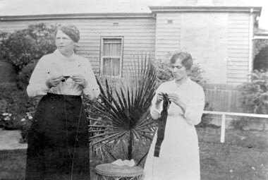
Work on paper - Photograph, Jane Slessar knitting for the Red Cross, WW1, 1914
Knitting socks for soldiers in the trenches in France was a common women's activity during WW1. Often white wool was knitted up and Condy's crystals were used to dye the socks a khaki colour. Jane Cook married William Slessar (land agent / farmer) in 1887. They had a family comprised of at least: Arthur, Frederick Alan, Gladys Isabella, William Cook, William Kenneth, Robert Harold. They lived at 17 Albert Crescent, Surrey Hills. William died in 1921; Jane in 1952 aged 90. They are buried in Box Hill Cemetery B-0086. Their son Arthur is buried with them. Their son William Cook Slessar was Killed in Action on 24 June 1916 in Belgium.Black and white photo of 2 women standing in a garden knitting. One is identified as Mrs Jane Slessor; the other is a younger woman. Between them is a cane table and a small palm. In the background is the side of the adjacent property - a timber Victorian home.knitting, red cross, world war, 1914-1918, albert crescent, box hill cemetery, jane slessar -
 Bacchus Marsh & District Historical Society
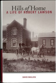
Book, Hills of Home: A Biography of Robert Lawson
... Landsberg Academy Robert Lawson 1826-1869 Isabella Lawson Robert ...Robert Lawson was the first Principal of Scotch College in Melbourne. He was Principal of Scotch College from 1851 until 1856. He later acquired land in the Pentland Hills near Bacchus Marsh and operated a school at Blackwood which he called the Landsberg Mains School. It was also known as the Landsberg Academy. The school opened in 1857 and operated under Lawson's direction until 1868. The school building was an imposing bluestone structure which came to be known as Landsberg House.The school was very successful for a time in the 1860s attracting students from across Victoria. Lawson died in 1869 and the school continued to operate until 1880 under a different Principal. Lawson is considered a pioneer educationalist in Australia. This is a substantial and scholarly biography about Lawson and his wife Isabella Wilson. Several chapters explore the time Lawson spent operating his school at Blackwood.Book, hard cover. First edition. Melbourne, Vic., Melbourne University Publishing, 2009. By David Baillieu. 389 pages. BMDHS Location: AR/SU63/S2 non-fictionRobert Lawson was the first Principal of Scotch College in Melbourne. He was Principal of Scotch College from 1851 until 1856. He later acquired land in the Pentland Hills near Bacchus Marsh and operated a school at Blackwood which he called the Landsberg Mains School. It was also known as the Landsberg Academy. The school opened in 1857 and operated under Lawson's direction until 1868. The school building was an imposing bluestone structure which came to be known as Landsberg House.The school was very successful for a time in the 1860s attracting students from across Victoria. Lawson died in 1869 and the school continued to operate until 1880 under a different Principal. Lawson is considered a pioneer educationalist in Australia. This is a substantial and scholarly biography about Lawson and his wife Isabella Wilson. Several chapters explore the time Lawson spent operating his school at Blackwood. schools bacchus marsh region, schools blackwood victoria, landsberg academy, robert lawson 1826-1869, isabella lawson