Showing 53 items
matching laburnum
-
 Whitehorse Historical Society Inc.
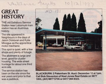
Article, Great history, 10/12/1997 12:00:00 AM
Cutting from the Whitehorse Gazette, 10/12/1997Cutting from the Whitehorse Gazette, 10/12/1997 regarding the auction of the old Salisbury Service Station near Laburnum Railway station to be conducted on 10 December at 1PM. The service station has been on the site since the war years and prior to that was a paddock. The site appeared in 'Neighbours' in the days of Jason Donovan and Kylie Minogue.Cutting from the Whitehorse Gazette, 10/12/1997salisbury service station, laburnum railway station, donovan, jason, minogue, kylie, steventon, bob, noel jones, auctions -
 Whitehorse Historical Society Inc.
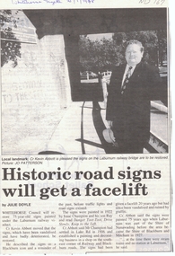
Article, Historic road signs will get a facelift, 1/01/1998 12:00:00 AM
Whitehorse Council will restore 75 year old signs painted under the Laburnum railway viaduct.Article from Whitehorse Gazette 21/1/1998 informing that Whitehorse Council will restore 75 year old signs painted under the Laburnum railway viaduct. The signs which have been vandalised and have badly deteriorated have been described as a Blackburn icon and a reminder of the past before traffic lights and road signs existed.Whitehorse Council will restore 75 year old signs painted under the Laburnum railway viaduct.city of whitehorse, abbott, kevin, champion, isaac, ray, shire of blackburn and mitcham, shire of nunawading -
 Whitehorse Historical Society Inc.
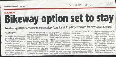
Article, Bikeway Option Set To Stay, 2017
VicRoads has announced its preferred southern alignment of the bicycle path between Middleborough Road and Blackburn Railway Station with only one week for residents to respond.bicycle paths, laburnum, vicroads, middleborough road, blackburn, blackburn railway station, laburnum street, blackburn village residents group -
 Kew Historical Society Inc
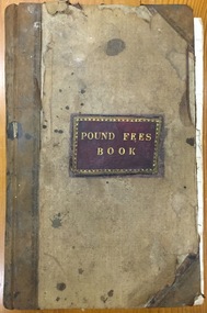
Administrative record (item), Borough of Kew, Pound Fees Book, 1874-1896
While the first successful land sales in Boroondara occurred in Hawthorn in 1843, and Kew in 1845, these areas were to be without local pounds until April 1858, when the Governor of Victoria, in accordance with Act 18 Victoria No 30, was pleased to direct the establishment of a Pound at Glass’s Creek on that part of land bounded by the Kilby Road, Burke Road and High Street. While the Governor was required to proclaim the establishment of a pound, the appointment of a poundkeeper was the responsibility of the Justices of the Peace in the local Court of Petty Sessions. The Pound took its name from the most distinctive natural feature of the area, Glass’s Creek, named after the early pastoralist Thomas Glass.The register is of historic significance as an indicator of suburban life in the second half of the 19th Century. It shows how farming and city life on the urban fringe were intimately connected. It is also significant to the early history of Hawthorn and Kew, who both claimed the Pound following their separation from the Boroondara Roads Board in 1861."Kew Pound Book"glass creek pound (kew), animal pound, dog pound, kew pound, j. smith, john oakes, samuel b. cash, edward s. delaney, emma oswin, samuel cash -
 Whitehorse Historical Society Inc.
Map, Nunawading Planning Scheme, 7/06/1994 12:00:00 AM
Local Section maps 1 - 4 with index. Geographical information system land Information Branch. Scale 1:10,000 Shows zoning under planning scheme.Local Section maps 1 - 4 with index. Geographical information system land Information Branch. Scale 1:10,000 Shows zoning under planning scheme.Local Section maps 1 - 4 with index. Geographical information system land Information Branch. Scale 1:10,000 Shows zoning under planning scheme.blackburn, blackburn north, blackburn south, forest hill, heatherdale, maps, nunawading, vermont, vermont south, town planning, burwood east, laburnum -
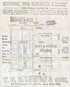 Whitehorse Historical Society Inc.
Document, Kings Padddock Blackburn
Plan showing land for sale at Kings PaddockPlan showing land for sale at Kings Paddock, Blackburn (second section).Plan showing land for sale at Kings Paddockauctions, kings paddock, blackburn, south parade, laburnum street, the avenue, fuchsia street, laurel grove, main street, t.r.b. morton & son -
Whitehorse Historical Society Inc.
Legal record - Land Title, Certificate of Title, 29/08/1922 12:00:00 AM
Certificate of Title, mortgage details and rate notices for Lot 24 Myrtle Grove, Blackburn owned by Alfred samuel Wright.Certificate of Title, mortgage details and rate notices for Lot 24 Myrtle Grove, Blackburn owned by Alfred samuel Wright.Certificate of Title, mortgage details and rate notices for Lot 24 Myrtle Grove, Blackburn owned by Alfred samuel Wright.wright, alfred samuel, certificates, myrtle grove, blackburn, lot 24, laburnum street, blackburn -
Whitehorse Historical Society Inc.
Map, Plan, 1939
Plan of subdivision, part of crown portion 83A and 83, Parish of Nunawading, County of BourkePlan of subdivision, part of crown portion 83A and 83, Parish of Nunawading, County of BourkePlan of subdivision, part of crown portion 83A and 83, Parish of Nunawading, County of Bourkestreet names, parish of nunawading, station street, blackburn, railway road, blackburn, vine street, blackburn, south parade, blackburn, laburnum street, blackburn, main street, blackburn, gardenia street, blackburn, the avenue, blackburn, fuschia street, blackburn, linum street, blackburn -
Whitehorse Historical Society Inc.
Article, Crossing work starts, 2003
Article on grade separation at Middleborough Road railway crossing; with items on maintaining tunnel design in proposed Mitcham Frankston Freeway.Article on grade separation at Middleborough Road railway crossing; with items on maintaining tunnel design in proposed Mitcham Frankston Freeway.Article on grade separation at Middleborough Road railway crossing; with items on maintaining tunnel design in proposed Mitcham Frankston Freeway.eastern freeway extension, railway crossings, middleborough road, blackburn, laburnum railway station -
Whitehorse Historical Society Inc.
Document, Francom's Paddock Blackburn, 1914
Auction of 80 lotsAuction of 80 lots at Francom's Paddock, BlackburnAuction of 80 lotst. r. b morton & son, francoms paddock, blackburn road, blackburn, canterbury road, south parade, main street, myrtle grove, laurel grove, laburnum street, the avenue, fuchsia street, view street, linum street, kings paddock, blackburn township estate, gardenia street -
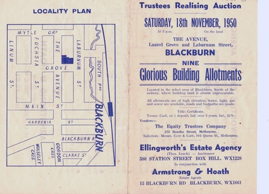 Whitehorse Historical Society Inc.
Document, Realising Auction, C1956
Trustee Realising AuctionTrustee Realising Auction 18/11/1956Trustee Realising Auction equity trustees company, ellingworth estate agency, armstrong & hoath, estate agents, corr & corr, solicitors, laburnum street, blackburn, the avenue, laurel grove -
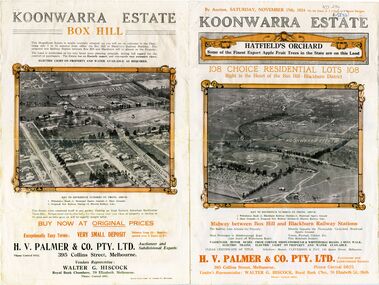 Whitehorse Historical Society Inc.
Document - Real Estate Notice, Koonwarra Estate Hatfield's Orchard, C1924
Land brochure giving details of auction of Koonwarra EstateLand brochure giving details of auction of Koonwarra Estate known as Hatfield's OrchardLand brochure giving details of auction of Koonwarra Estate land sales, koonwarra estate, hatfield's orchard, middleborough road, blackburn, canterbury road, laburnum street, hillside crescent, salisbury avenue, rymer street, pakenham street, park street, myrtle grove, h. v. palmer & co. pty. ltd., hiscock, walter g -
 Whitehorse Historical Society Inc.
Document - Leaflet, Blackburn Land Sale, 19/11/1910 12:00:00 AM
Pamphlets showing sale of land Gardenia Street, Blackburn and surrounding streets.Pamphlets showing sale of land Gardenia Street, Blackburn and surrounding streets. Schedule of prices. Hand drawn mapPamphlets showing sale of land Gardenia Street, Blackburn and surrounding streets.blackburn township estate co. ltd., blackburn railway station, south parade blackburn, laburnum street, blackburn, the avenue blackburn, fuschia street blackburn, linum street blackburn, main street, t.r.b.morton. & son, land subdivision -
Whitehorse Historical Society Inc.
Letter - Correspondence, Blackburn District Girl Guides Association, 1/11/1987 12:00:00 AM
Letters and notes sent to Keith Rooney about local Girl Guides Groups for use in Nunawading Bicentennial celebrations.Letters and notes sent to Keith Rooney about local Girl Guides Groups for use in Nunawading Bicentennial celebrations.Letters and notes sent to Keith Rooney about local Girl Guides Groups for use in Nunawading Bicentennial celebrations.blackburn district girl guides association, laburnum district girl guides, blackburn south girl guides district local association, croydon west girl guides local association, cathcart, heather, faulkner, elizabeth a, hopkins, p, bennett, jean, rooney, keith -
Whitehorse Historical Society Inc.
Article, Grandmother fights cut to remedial education
Mrs Cath Arthur is fighting Ministry of Education over threatened closure of remedial physical education service.Mrs Cath Arthur is fighting Ministry of Education over threatened closure of remedial physical education service.Mrs Cath Arthur is fighting Ministry of Education over threatened closure of remedial physical education service.disabled, arthur, cath, victoria. education department, remedial physical education service, laburnum primary school no.4863 -
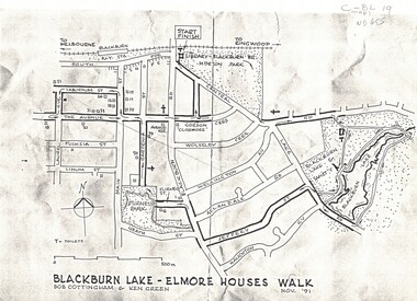 Whitehorse Historical Society Inc.
Map, Blackburn Lake - Elmore houses walk, 1/11/1991
Map of Blackburn outlining a walk through the lake.Map of Blackburn outlining a walk through the lake. The route includes four Elmore houses.Map of Blackburn outlining a walk through the lake.maps, blackburn lake sanctuary, the avenue, blackburn, laburnum street, main street, gardenia street, blackburn road, gordon crescent -
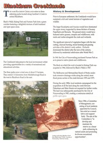 Whitehorse Historical Society Inc.
Pamphlet, Blackburn Creeklands, 1/08/1990 12:00:00 AM
Sympathetic treatment of creek banks and preservation and regeneration of bushland will encourage wildlifeSympathetic treatment of creek banks and preservation and regeneration of bushland will encourage wildlife, development of wetlands has encouraged water birds, provision of play equipmentSympathetic treatment of creek banks and preservation and regeneration of bushland will encourage wildlifeparks and reserves, blacks walk, kalang park, furness park, city of nunawading, melbourne and metropolitan board of works, middleborough road, blackburn, pakenham street, blackburn road, gardiners creek, laburnum primary school no. 4863 -
 Whitehorse Historical Society Inc.
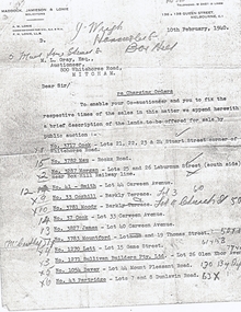
Document, Land Sales
Letter from A. M. Lonie of Maddock, Jameson & Lonie, solicitors to M.L. Grey Esq , Auctioneer,Letter from A. M. Lonie of Maddock, Jameson & Lonie, solicitors to M.L. Grey Esq , Auctioneer, 800 Whitehorse Rd, Mitcham regarding charging orders for land sales.Letter from A. M. Lonie of Maddock, Jameson & Lonie, solicitors to M.L. Grey Esq , Auctioneer,cock, stuart street, blackburn, whitehorse road, mau, rooks road, mitcham, morgan, laburnum street, lots 25, 26, smith, carween avenue, lot 44, coghill, barkly terrace, lot 3, moody, church street, lot 4, cook, lot 33, james, lot 40, mountford, thomas street, lot 19, lett, game street, lot 15, sullivan builders pty ltd, glen ebor avenue, lot 26, davey, mount pleasant road, forest hill, partridge, dunlavin road, lots 7 & 8, wright, mcdowall street, lots 106 - 7, gibb, lot 9 -
Whitehorse Historical Society Inc.
Map, Blackburn Lake - Elmore houses walk, 1/10/1991
Walking map, Ken Green. Copy 1 :Walking map, Ken Green. Copy 1 : Oct '91. See C-B 19 ND655 for copies marked 'November '91'.Walking map, Ken Green. Copy 1 : elmore houses, blackburn lake sanctuary, blackburn, the avenue, blackburn, laburnum street, blackburn, main street, blackburn, gardenia street, blackburn -
 Whitehorse Historical Society Inc.
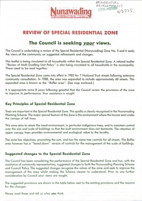
Document - Pamphlet, Review of special residential zone, 1973
City of Nunawading: review of special residential zone: seeking exemptions from residents on existing zone provisions 1973residential development, land use, city of nunawading, laburnum street, blackburn, the avenue, fuschia street, myrtle grove, linum street, acacia avenue, laurel grove, boongarry avenue, main street, gardiner street, blackburn road, jeffery street, naughton grove, special residential zone -
 Whitehorse Historical Society Inc.
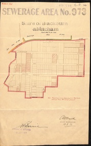
Document, Sewerage Area, 19/08/1933
Map dated 19 - 8 1933 showing sewerage area no. 973 in the Shire of Blackburn and Mitcham. Note that View Street on the plan is now Linum Street.sewerage and sanitation, shire of blackburn and mitcham, acacia avenue, blackburn, salisbury avenue, laburnum street, view street, derby street, myrtle grove, south parade, the avenue, main street, laurel grove, pakenham street, blackburn., linum street -
Whitehorse Historical Society Inc.
Map, Melbourne and Metropolitan Board of Works, Feb 1982
Map area: North - Laburnum and Blackburn Stations East - Blackburn Lake South - bordering Canterbury Road West - Middleborough Roadnon-fictionMap area: North - Laburnum and Blackburn Stations East - Blackburn Lake South - bordering Canterbury Road West - Middleborough Roadmaps, melbourne and metropolitan board of works, parish of nunawading -
Canterbury History Group
Map - Victorian Railways East Camberwell to Laburnum. Diagram No.3' 58, 1/05/1958 12:00:00 AM
Diagram showing proposed signal and interlocking arrangements for the East Camberwell to Laburnam line 1958canterbury, canterbury station, victorian railways, railway lines