Showing 44 items
matching lake road estate
-
 Whitehorse Historical Society Inc.
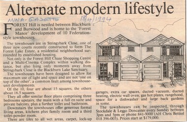
Article, Alternate modern lifestyle, 18/04/1994 12:00:00 AM
Advertisement for ten federation style townhouses for sale at 'Forest Manor', Stringybark Close, the Forest Lake Estate, Forest Hill..Advertisement for ten federation style townhouses for sale at 'Forest Manor', Stringybark Close, the Forest Lake Estate, Forest Hill.. Open for inspection every Sunday, prices starting from $179,000.Advertisement for ten federation style townhouses for sale at 'Forest Manor', Stringybark Close, the Forest Lake Estate, Forest Hill..stringybark close, forest hill, forest hill chase, blackburn lake sanctuary, federation style, forest lake estate, stockdale & leggo (estate agents), land sales -
 Whitehorse Historical Society Inc.
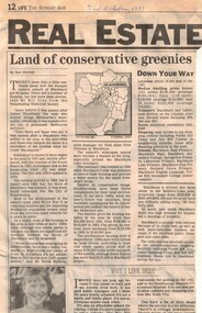
Article, Land of conservative greenies, 30/10/1993 12:00:00 AM
Newspaper article 'Land of conservative greenies' by Ben Mitchell, 30 October 1993 on development in Blackburn.Newspaper article 'Land of conservative greenies' by Ben Mitchell, 30 October 1993 on development in Blackburn. Includes quotes from Bill Gray (Nunawading Historical Society) and Kevin Rafferty (Noel Allen First National Real Estate) and brief history of Blackburn,Newspaper article 'Land of conservative greenies' by Ben Mitchell, 30 October 1993 on development in Blackburn. land use, blackburn, gray, bill, rafferty, kevin, stephens, amanda, blackburn lake sanctuary -
 Whitehorse Historical Society Inc.
Newspaper - Article, 18 Wellington Avenue, Blackburn, 30/06/1993
18 Wellington Avenue, Blackburn, Auction, 3 July 1993. Bellbird / Blackburn Lake Estate.wellington avenue, blackburn, auctions -
 Whitehorse Historical Society Inc.
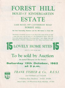
Document, Forest Hill Estate, 13/10/1962 12:00:00 AM
... Called Forest Hill Estate in Lake Road, Forest Hill..... on 13 Oct 1962 called Forest Hill Estate in Lake Road, Forest... Mitcham melbourne Called Forest Hill Estate in Lake Road, Forest ...Fifteen home sites to be auctioned by Frank Fisher & Co. on 13 Oct 1962.Fifteen home sites to be auctioned by Frank Fisher & Co. on 13 Oct 1962 called Forest Hill Estate in Lake Road, Forest Hill.Fifteen home sites to be auctioned by Frank Fisher & Co. on 13 Oct 1962.forest hill estate, lake road, forest hill, frank fisher co. -
 Federation University Art Collection
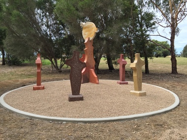
Sculpture, 'Mungo Moon' by Don Barrett, 2015
'Mungo Moon' by Don Barrett is the first sculpture erected on the Churchill Art and Culture Pathway. It was officially unveiled by Professor David Battersby on 15 April 2015 From Churchill & District News 16 October 2014 The Churchill Art and Culture Walking Pathway will have its official public opening on Saturday October 18, with a walk finishing at Federation University Australia’s Switchback Gallery at the Federation University Gippsland Campus. ... An important link on the newly developed pathway was recently completed with a path south of the FedUni Student West Residences. The path now allows walkers to turn off the Eel Hole Creek path before reaching Glendonald Estate and to follow a picturesque, tree lined walkway to join up with the footpath on the Eastern side of Northways Road. From there the footpath joins into Federation University’s network of walking paths that proceeds past the Switchback Art Gallery, down through the pine plantation and along Lake Kretlow and the Churchill Golf Course. Project Manager Mike Answerth, said the opening of the West Residences section of the path means there is now only one short link to complete. “We’re now very close to realising the project’s objective to join up all these walking paths to provide a continuous pathway that encompasses town, campus and parkland. The next stage of the project will be the completion of Latrobe City’s East West Link and the enhancement of the walking path with artistic and cultural features.” said Mr. Answerth. Head of Federation University Australia Gippsland Campus, Dr Harry Ballis, said the project had been made possible through the contributions of the five former Gippsland Education Precinct (GEP) partners. “The Art and Culture Pathway represents another important step in joining the Churchill township and the university campus as a physical and social entity,” Dr Ballis said. “This was an initiative of the GEP and it is pleasing to see it coming to fruition.” The path now reaches as far as the golf driving range but plans are already under way to connect with the Mathison Park board walk and pathway, which surrounds Lake Hyland in Churchill. When the loop is completed, residents and visitors will have an approximately 5km circular walking path which links up the Churchill town centre, Federation University Australia and Mathison Park. There are already art features along this route, including primary schools’ Bug Blitz totems near the Kurnai College school crossing, native vegetation and history panels near the Hare Homestead in Mathison Park, and outdoor sculptures in the pine trees near the Federation University Switchback Gallery. contemporaryA large sculpture in five pieces set in an external location. It is part of the Churchill Art and Culture Walking Pathway. Don Barrett’s work is mainly in concrete with added coloured oxides to portray the feeling of the Australian landscape. Barrett focuses on concepts of Australia’s short history and indigenous history. churchill art and culture pathway, barrett, don barrett, gippsland campus, federation university, churchill, sculpture -
 Vision Australia
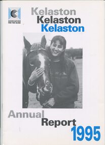
Administrative record - Text, Association for the Blind of Victoria 'Kelaston' 38th Annual Report 1995, 1995
Annual report on activities and financial performance of Kelaston, including the transition in funding model, launch of the Centenary Appeal to raise $1M to rebuild Kelaston, a staff team won the Ekiden Relay around Lake Wendouree, new service opened in Warracknabeal, long time committee member David Baird received an OAM, four residents enjoyed a holiday to Tye Estate at Romsey, two residents sailed on the tall ship 'Alma Doepel, two bantam hens and one rooster to the existing Cam and Sam cats as pet therapy, National Centre for Ageing and Sensory Loss chose Kelaston to be the location for it's training video, development of a attendant button when in the lounge of an evening when there is less staff, companion visiting program has begun, a Kelaston team won the Victorian A Grade Blind Bias Bowls in regional and state finals, and 'Keloca' Day centre in Avoca officially opened by Hon Rob Knowles, Minister for Aged care and Housing.1 printed volume with illustrationskelaston home (ballarat), association for the blind, corporation records -
 Lakes Entrance Historical Society
Photograph - Housing, 1999 c
Image used by King and Heath, Estate Agents: 'Home for Sale $199,500. (Lakes Post 29.9.1999)A colour photograph of a brick dwelling at 6 Henderson Road. House has hipped roof, veranda over front and side, five steps from the garden at front and carport at side. Toorloo Arm Victoriahouses, architecture -
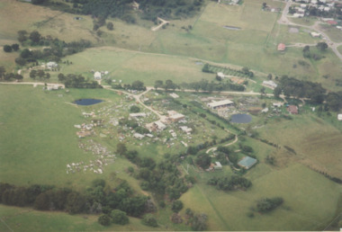
 Lakes Entrance Historical Society
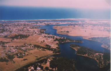
Photograph - North Arm Lakes Entrance, 1993c
Also second aerial photograph showing Blairs Road track to Wyanga Winery glimpse of Tarra Landing number 03857.1 size 10 x 15 cmAerial photograph of North Arm Frenchmans Gully and Wyanga Winery lower left Tarra Landing estate centre North Arm and Cunninghame Arm Lakes Entrance Victoriaaerial photograph, houses, settlement, township -
 Lakes Entrance Historical Society
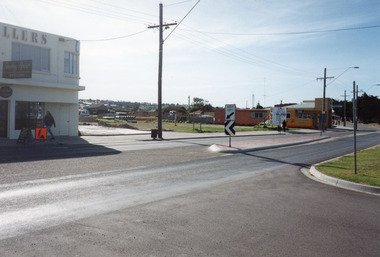
Photograph - Esplanade Lakes Entrance, Holding M, 1994
Date made May 1994Colour photograph of the old carnival site on Esplanade. It shows a corner of Something Special Jewellers on left, preparations for construction of Safeway in distance, C H Daniels Hooker Real Estate Agency on right, part of the road and Princes Highway, divided by traffic island. Entry to lakeside parking bay in right foreground. Lakes Entrance Victoriatownship, retail trade, roads and streets -
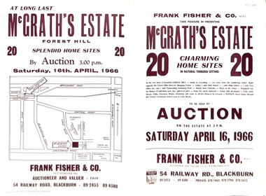 Whitehorse Historical Society Inc.
Document - Auction Flyer, McGrath's Estate Auction 1966, 16/04/1966 12:00:00 AM
Auction of 20 home sites in McGrath's Estate, Ottawa Ave, Forest Hill by Frank Fisher & Co on 16 April 1966.Auction of 20 home sites in McGrath's Estate, Ottawa Ave, Forest Hill by Frank Fisher & Co on 16 April 1966.non-fictionAuction of 20 home sites in McGrath's Estate, Ottawa Ave, Forest Hill by Frank Fisher & Co on 16 April 1966.mcgrath's estate, forest hill, forest hill, frank fisher co., peak court, forest hill, ottawa avenue, forest hill, beatrice court, forest hill, lake road, forest hill -
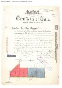 Ringwood and District Historical Society
Document, Certificate of Title - Theodore Hartley Burchett - part of Crown Section 20, Parish of Warrandyte, County of Evelyn - 1911
A4 copies of Landata Victoria Historical Search documents - Vol 3520 Fol 703991.Theodore Hartley Burchett of Lara Lake, Farmer, is now the proprietor of an Estate in Fee-simple subject to the Encumbrances notified hereunder ... 180 acres 01 rood 27 perches or thereabouts, being lots 1, 8, 9 and 10 on plan of subdivision no.4315. Subdivision map includes un-named roads - lower western side is Wonga Road (later Warranwood Road), and eastern side is Grandview Grove (later Bemboka Road), both north of Plymouth Road, Ringwood, Vic. Transfers include Anna Maria Wicks and Henry James Trowbridge, 3rd October, 1911 Elizabeth Ann Walden, 18th September, 1912 - 28ac 3rds 5per. Edward Thomas Miles, 22nd September, 1913 - 27ac 19per. Samuel Styles, 10th October, 1916 - balance. -
 Lakes Entrance Historical Society
Photograph - Lakes Entrance, 1993c
Red brick house on right O'DonnellsColour aerial photograph of Blair Road showing first few dwellings of housing estate Tarra Landing in background Lakes Entrance Victoriaaerial photograph, township -
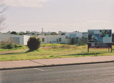 Lakes Entrance Historical Society
Photograph - Esplanade Lakes Entrance 2000, M Holding, 2000 c
Original building relocated to Mill Point Road Lake Tyers BeachColour photograph of untidy site on Esplanade between Toyworld and hairdressing salon after removal of original building. King and Heath Estate Agents board on site advertising an ambitious development for a residental complex which did not eventuate Lakes Entrance Victoriabusinesses, roads and streets -
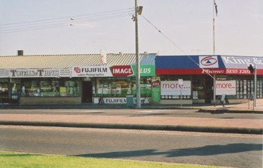 Lakes Entrance Historical Society
Photograph - Esplanade Lakes Entrance Victoria 2006, M Holding, 2006
Site originally Mrs Zetic Bakers St Rosiers House. Carstairs Park Inn prior to demolitionColour photograph of businesses on the corner of Esplanade and Myers Street, Towels and Things and Lakes Photographics facing Esplanade, King and Heath estate agents on corner Lakes Entrance Victoriabusinesses, roads and streets, historic sites