Showing 104 items
matching laneway
-
 Port Melbourne Historical & Preservation Society
Map, City of Port Melbourne, Oct 1963
Gives a visual understanding of the Port Melbourne area in 1963A detailed map of the Port Melbourne area in October 1963. Details roads and laneways, undeground cables, light and power poles, sewer, bridges, piers reserve and park areas.local government, built environment, piers and wharves, natural environment - beaches and foreshore, parks and gardens, piers and wharves - princes pier, piers and wharves - station pier, engineering - roads streets lanes and footpaths, engineering - canals and drainage -
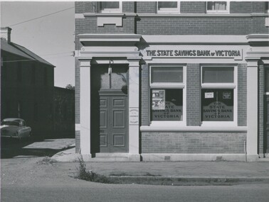 Bendigo Historical Society Inc.
Photograph - STATE SAVINGS BANK OF VIC, INGLEWOOD
Black and white photograph. Brick building (corner in Inglewood). The State Savings Bank of Victoria. Car in laneway at L. On back: MP 278 (copy 1); , RHSV stamp, 94Alan Doney (ref. J Lerk 10/3/2000buildings, bank, state savings bank of victoria, see also: 2000.551.01 (copy), 2000.554.01 -
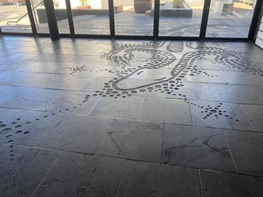 City of Ballarat
Artwork, other - Public Artwork, Diana Nikkelson, Goanna Ground by Diana Nikkelson, 2006
This is an Aboriginal artwork that depicts a Goanna Totem. Designed by Ballarat-based, Gunditjmara artist Aunty Diana Nikkelson, the design is inspired by the artist’s totem and is a tribute to the first artists of the region, the Wadawurrung people. It acknowledges Aboriginal survival and the dynamic regeneration of the Aboriginal art and culture in the region. The artwork is in-set to the basalt paving along Police Lane by a series of etched footsteps, which evolve from human footprints to goanna prints as viewers approach the rear of the Art Gallery of Ballarat. The artwork was originally located only outdoors and half of it was brought into the Art Gallery of Ballarat in 2011, when the former Federation Plaza was enclosed to form the Art Gallery of Ballarat's McCain Annexe. The artwork was created in 2006 as part of the cultural festival of the Commonwealth Games. The artwork is of cultural and aesthetic significance to the people of BallaratSand blasted petroglyph forms into bluestone on laneway surface. The carved inlay of the Goanna Totem design into the bluestone of Police Lane (beside Art Gallery of Ballarat) continues inside the building.goanna totem ballarat, goanna totem, diana nikkelson, aboriginal, dreaming, nikkelson, gunditjmara -
Glenelg Shire Council Cultural Collection
Photograph - Photograph - Julia Street Portland, c. 1970
Photographic print of a rephotographed photograph. Image shows buildings on south side of Julia Street, between Percy and Bentinck Streets Portland. Double storey building next to laneway. Britannia Hotel.Front: 'Julia Street' - green ink Back: 'Julia Street from George Taylors to paper shop' - blue biro -
Federation University Art Collection
Artwork - printmaking, Tony Irving, A suite of seven limited edition prints of Melbourne Laneways by Tony Fraser
Tony Irving's works shows a snapshot of urban life, with the artist depicting various locations and laneways in Melbourne. In the 1970s, he won the prestigious National Gallery of Victoria's John McCaughey Acquisitive Prize. These seven etchings are the subject of the Private Press book: ‘The Laneways of Melbourne’ written by John Arnold, The Lytlewode Press, Melbourne, 2001. A suite of seven framed limited edition prints produced by the etching and aquatint process on copper plate. .1) Ramsden Place Etching & Aquatint Copper Plate Plate 34.0cm x 14.7cm Paper 63.0cm x 47.0cm Edition 89/100 .2) Waratah Place Etching & Aquatint Plate 34.0cm x 18.6cm Paper 63.0cm x 47.0cm Copper Plate Edition 89/100 .3) Chapter House Lane Etching & Aquatint Plate 35.0cm x 14.0cm Paper 63.0cm x 47.0cm Copper Plate Edition 89/100 .4) Heape Court Etching & Aquatint Copper Plate Plate 34.0cm x 19.2 cm Paper 63.0cm x 47.0cm Edition 89/100 .5) Drewery Lane Etching & Aquatint Copper Plate Plate 34.0cm x 18.8cm Paper 63.0cm x 47.0cm Edition 89/100 .6) Niagara Lane Etching & Aquatint Copper Plate Plate 35.2cm x 17.5cm Paper 63.0cm x 47.0cm Edition 89/100 .7) Hosier Lane Etching & Aquatint Copper Plate Plate 33.8cm x 14.6cm Paper 63.0cm x 47.0cm Edition 89/100 Donated through the Australian Government Cultural Gifts Programme by Katherine N. Littlewood, 2014 artist, artwork, laneways, printmaking, etching, irving, tony irving, churchill, gippsland campus -
Canterbury History Group
Photograph - Shop assistant of No. 112 Maling at the back door of shop, Jan Pigot, 27/03/1993 12:00:00 AM
Coloured photograph of the shop assistant from Grandma Greens at the back door of the shop No. 112 Maling Road. Also shows a view of the laneway that runs from the carpark at the rear of Maling Road to the street front.canterbury, maling road, shops, laneways -
 City of Ballarat
Artwork, other - Public Artwork, Incidents in Time by Jason Waterhouse, 2011
Incidents in Time consists of a number of small, whimsical artworks tucked in to the small nooks and crannies that are a feature of Time Lane. This laneway was once a narrow watchmakers shopfront that ran the entire length of the lane and was packed with the accoutrements of a busy 19th Century store. The tiny works are miniature landscapes depicting moments in time, from the banal, to the sublime, to the strange. They spill out onto the laneway and are a treasure hunt for the audience of shoppers and passers-by. Incidents in Time is of aesthetic significance to the people of BallaratSmall cast metal forms installed into brick walls of Time Lane, BallaratSmall cast bronze panels with titles of each vignette -
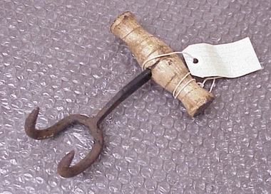 National Wool Museum
Bale Hook
Found by RC and J Lewis in laneway running south from Western Beach Road between Dalgety North building and Dennys Lachelles building (old Corio Tannery site). -
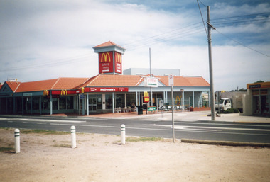 Lakes Entrance Historical Society
Photograph - MacDonalds Restaurant, Bennett, Vera, 2003c
The McDonalds store was opened on 19 December 1987Colour photograph of McDonald's restaurant, Esplanade. A small truck on laneway between McDonald's and Hookers Estate Agent. In foreground three bollards to limit parking on verge between Princes Highway and lake. Building of shops behind McDonald's being commenced. Lakes Entrance Victoriatownship, restaurant -
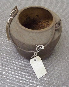 National Wool Museum
Pot, smelting
Found by Roger Cummings and J Lewis in laneway running south from Western Beach Road between Dalgety North building and Dennys Lachelles building (old Corio Tannery site). -
National Wool Museum
Pot, smelting
Found by Roger Cummings and J Lewis in laneway running south from Western Beach Road between Dalgety North building and Dennys Lachelles building (old Corio Tannery site). -
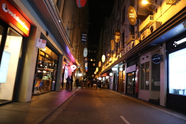 Ballarat Heritage Services
digital photographs, degraves street, 2017
heritage, melbourne, lane, laneway, restaurants, night -
Glenelg Shire Council Cultural Collection
Photograph - Photograph - Julia Street Portland, c. 1970
Photographic print of a rephotographed photograph. Image shows buildings on north side of Julia Street, between Percy and Hurd Street. Single story building on right, then double storey, bluestone building - residence of Dr Grier; laneway, then single storey building. Man holding horse at entrance to lane.Front: 'guest house ops Lutheran Church' - blue biro -
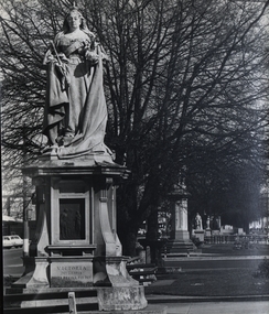 Federation University Historical Collection
Photograph - Photographs, Geoff Biddington, Ballarat Photographs, 1967, 1967
Black and white photographs of Ballarat buildings .1) Spiral Staircase .2) Union Hotel, Ballarat .3) Queen Victoria statue, Sturt Street .4) St Patrick's Cathedral gates .5) Shingle roof in Ballarat .6) Bluestone laneway .7) St Alipius', Ballarat East geoff biddington, ballarat, union hotel ballarat, queen victoria statue, shingle roof, blustone laneway -
 Bendigo Historical Society Inc.
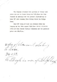
Document - COHN BROTHERS COLLECTION: LANEWAY DOCUMENT, 1959
Document relating to a transfer of part of Bridge Lane and a 33' wide laneway between Bridge St. and Bridge Lane. The 33' strip of land was obtained from Andrew Sylvester Doyle of Finn St. Bendigo, Cellarman. Written in ink at the bottom is ' copy of document relating to lane 24/2/1959'organization, business, land transfer, cohn brothers , bridge street , bridge lane, andrew sylvester doyle -
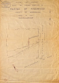 Ringwood and District Historical Society
Map, Plan of Survey, Part of CP12, Adelaide Street, Ringwood, Circa 1920s
Undated map of part of commercial area in Parish of Ringwood, County of Mornington showing Adelaide Street, Whitehorse Road, and un-named laneway behind Whitehorse Road shops marked as Road, and New Road Alignment. Made by H.J. Macey, Licensed Surveyor 36 Narissa Street Burwood BX1917. -
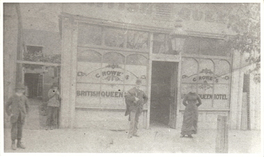 Bendigo Historical Society Inc.
Photograph - BRITISH QUEEN HOTEL: BENDIGO, late 1800's
The "British Queen Hotel", in Bridge street, Bendigo was first licensed to Squire Barlow (1817-1882), a Lancashire man who came to Australia in 1853 with his two eldest sons, travelling on the "Goldfinder". His wife Mary (nee Taylor, 1814-1891) soon followed with the rest of their children. One more child was born in Sandhurst in 1856. Squire and Mary had married in 1838, "The British Queen" was taken over by John Crowe (1825-1882) some time after 1876. John had previously been the licesee of the Globe Hotel, also in Bridge Street. When John died in 1881, his son Robert Phillip Crowe (Phillip) transferred the licence to John Hope in 1882.Black and white photograph. Buiilding Crowe's British Queen Hotel, 4 people, 2 boys at left, man with hat at centre, lady with long dress centre right. Large hotel light above door, laneway beside building at left with creeper above. On windows of building ' Crowe's British Queen Hotel' On parapet, partially visible ' British Queen..'cottage, miners -
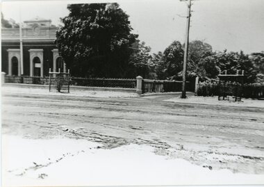 Stawell Historical Society Inc
Photograph, Stawell Shire Hall built 1866, c 1949
Black & white photograph of Stawell Shire Hall, taken in July 1949 when Stawell had a heavy snow fall. The photo shows the Shire Hall to the left of trees, with a laneway beside. A telegraph pole stands on the right side of the lane. The lane called Millers Lane was named in 2012. The snow fall occurred on the 18th of July 1949.Black & white photograph of the Stawell Shire Hall and Millers Lane. The photograph was taken in 1949 when snow had fallen in Stawell. Millers Lane has a telegraph pole on the corner. Longfield road looks cleared of snow but thick on either side of the road. Two tree guards can be seen in the street verge either side of Millers Lane. stawell shire hall -
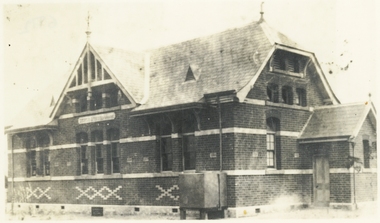
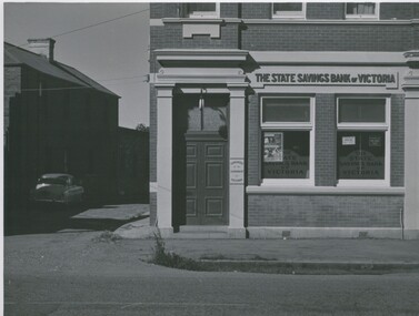 Bendigo Historical Society Inc.
Photograph - STATE SAVINGS BANK OF VIC, INGLEWOOD
Black and white photograph. Brick building (corner in Inglewood). The State Savings Bank of Victoria. Car in laneway at L. On back: MP 278, copy 2, 2 copies, 93, RHSV stamp. In image: 'The State Savings Bank of Victoria' Above windows on building. On each of two windows 'The State Savings Bank of Victoria'. On pillar near door 'Guaranteed by the Government of Victoria'.Alan Doney (ref. J Lerk, (10/03/2000)buildings, bank, state savings bank of victoria -
Port Melbourne Historical & Preservation Society
Photograph - Police residences, Graham Street, Public Records Office Victoria (PROV), 1920s - 1930s
COPYRIGHT Public records Office Victoria Black and white photos from DVD .02 Sergeant's residence (1 TIFF and 1 JPEG copy) .03 Front door of residence (1 TIFF and 1 JPEG copy) .04 Front of site at Graham St for proposed residence (1 TIFF and 1 JPEG copy) .05 Rear of site in laneway behind Graham St (1 TIFF and 1 JPEG copy)built environment - civic, built environment - domestic, police, law, police station -
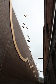 City of Ballarat
Artwork, other - Public Artwork, Sue Buchanan et al, Gold Fever by Eli Giannini and Sue Buchanan, 2011
Gold Fever illuminates Drury Lane walkway entrance to Bridge Street Mall. The multiple metal forms act like mobiles suspended from the wall line out into the centre of the walkway. The flexing motion of the rolled metal and traffic reflectors wrapped on the ends creates movement and reflections in the laneway. This movement follows a pricing graph for gold from 1851 to 2011. This zigzagging golden graph line tells the tale of the gold rush spreading like lightning across the world. The artwork is of historic and aesthetic significance to the people of Ballarat Gold coloured bended metal, painted metal formed wall fitting and stoppers reflectors installed on wallGOLD FEVER/ Artists: Sue Buchanan and Eli Gianninigold fever, gold rush ballarat -
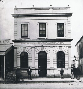 Bendigo Historical Society Inc.
Photograph - COLONIAL BANK OF AUSTRALASIA, 1860's
Black and white copy of photo taken by Batchelder. Colonial Bank of Australasia. 2 storey rendered building, with parapet and orbs. 1st floor 3 rectangular windows, ground floor 2 arched windows and central arched doorway. 6 adult males on footpath at front. Single storey shop with verandah at left. Batchelder photographic cart at left front , at right, laneway with gas lamp above. At far right, double storey building. In image ' Manufacturing/Goldsmiths' On back in pencil '41'Batchelderbuildings, bank, colonial bank of australia -
 Ringwood and District Historical Society
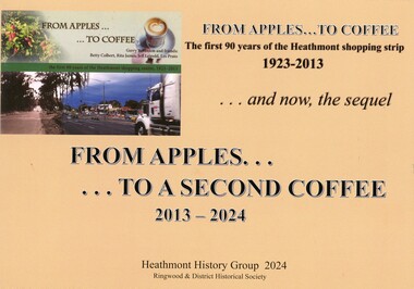
Book - Heathmont Shopping Strip, From Apples to a Second Coffee 2013-2024
Soft covered wire bound book. Sequel to earlier book titled The First 90 years of Heathmont Shopping Centre 1923-2013.Contents: Area 1 - West side odd numbers - 95 Canterbury Road down to trainline Area 2 - West side odd numbers - from trainline up to 165 Canterbury Road Area 3 - East side even numbers - from Allens Road down to laneway Area 4 - East side even numbers - from laneway down to trainline What cannot be purchased in Heathmont in 2024 Strip Series: annual changes 2014 to 2024 Covid pandemic 2019-2020 Future directions Current HHG and Heathmont publications list. Acknowledgements: Heathmont History Group members - Laurie Allen, David Gee, Gerry Robinson, Ray Stevens, Trevor Weir. Sketches by David Williams (dec.). Ringwood & District Historical Society. -
 Ringwood and District Historical Society
Photograph, Twenty photographs of Ringwood in frames, 1990
Returned to RDHS from Federation Estate Art GalleryPhoto 1 (7009a) - Former "Ringwood Mail" newspaper office, Adelaide Street, 1955, looking along laneway to west. Lane between Bamford's Timber Yard, corner Warrandyte Rd. and Maroondah Highway, and went to Melbourne St, later called Civic Place. Other buildings were Ham's Billiard Saloon, the two-story Renong Chambers, bottom left Jack Orr's clothes hoists and bottom right Horman & Woolhouse plumbers. All demolished for the building of Eastland in the 1960s. The photo shown is a typical example but may not be in the collection. -
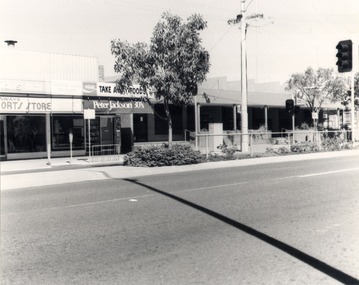 Wodonga & District Historical Society Inc
Photograph - Codling Collection 01 - Eastern side of High Street, Wodonga, 1980s
Miss Olive Codling was a Foundation Member and a Life Member of the Wodonga Historical Society. Many of her prize-winning photos are held in the Society Collection. She also held a range of roles and committee positions in a wide range of Wodonga community organisations. These included the Horticultural Society, the Wodonga Arts Council, the Wodonga Camera Club and the Wodonga Lapidary Club. This photo collection is significant as it documents how the businesses and buildings in Wodonga have evolved and contributed to community throughout the 20th century.Eastern side of High Street, Wodonga. From left Tony Conway's Sports Store, Coffee Lounge Lunch Bar and Take Away and the Post Office. Tony Conway later extended into the Take Away store. To the right of the Post Office was a laneway and then the Wodonga Shire Offices. Tony Conway opened his store with partner Jake Elkington in late 1961. In 1969 he bought the former RSL Hall and moved the Sports Store from across the road in High Street. It stayed in the family until 2007 under the management of Nic Conway.wodonga businesses, high st wodonga, conway's sports store -
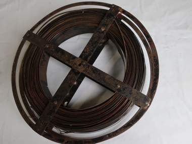 Kiewa Valley Historical Society
Surveyors Chain - Steel Band
A chain is a unit of length equal to 66 feet or 22 yards. This is a statute measure in the United Kingdom. One link is 100th part of a chain, which is 7.92 inches (20.1 cm). The chain and link became standard surveyors' units of length and crossed to the colonies from the United Kingdom. The chain is the unit of linear measurement for the survey of the public lands as prescribed by law. In Australia most building lots in the past were a quarter of an acre, measuring one chain by two and a half chains. Also street frontages, roads, laneways. The chain also survives as the length of a cricket pitch, being the distance between the stumps. Surveyors and residents of the Kiewa Valley used the Steel Band Surveyors Chain to measure distances when developing the land.Surveyors' steel band measuring tape, known as a 'standard band', or a 'steel band chain'.This chain consists of a long narrow strip of steel of uniform width of 3 mm and thickness of 0.3 to 0.6 mm. The chain itself is between 20 m and 30 m long.surveyors, surveyors chain, measurement of distance -
 Kew Historical Society Inc
Plan, Melbourne & Metropolitan Board of Works : Borough of Kew : Detail Plan No.1576, 1904
The Melbourne and Metropolitan Board of Works (MMBW) plans were produced from the 1890s to the 1950s. They were crucial to the design and development of Melbourne's sewerage and drainage system. The plans, at a scale of 40 feet to 1 inch (1:480), provide a detailed historical record of Melbourne streetscapes and environmental features. Each plan covers one or two street blocks (roughly six streets), showing details of buildings, including garden layouts and ownership boundaries, and features such as laneways, drains, bridges, parks, municipal boundaries and other prominent landmarks as they existed at the time each plan was produced. (Source: State Library of Victoria)This plan forms part of a large group of MMBW plans and maps that was donated to the Society by the Mr Poulter, City Engineer of the City of Kew in 1989. Within this collection, thirty-five hand-coloured plans, backed with linen, are of statewide significance as they include annotations that provide details of construction materials used in buildings in the first decade of the 20th century as well as additional information about land ownership and usage. The copies in the Public Record Office Victoria and the State Library of Victoria are monochrome versions which do not denote building materials so that the maps in this collection are invaluable and unique tools for researchers and heritage consultants. A number of the plans are not held in the collection of the State Library of Victoria so they have the additional attribute of rarity.Original survey plan, issued by the MMBW to a contractor with responsibility for constructing sewers in the area identified on the plan within the Borough of Kew. The plan was at some stage hand-coloured, possibly by the contractor, but more likely by officers working in the Engineering Department of the Borough and later Town, then City of Kew. The hand-coloured sections of buildings on the plan were used to denote masonry or brick constructions (pink), weatherboard constructions (yellow), and public buildings (grey). Development in the 20th century has irreparably altered that part of Kew represented in this plan. In the block bounded by Cotham Road, Charles Street, Wellington Street and Gellibrand; just one house standing in 1903 remains. This block included two of the most historic houses in Kew: ‘Ordsall’ (later ‘Southesk’) and ‘Madford’ (previously ‘Elm Lodge’). Ordsall was the home of the second chairman of Kew, John Halfey. It contained some of the most significant interior murals in Kew, created for Halfey by artists working for Cullen & Co. It was demolished in 1960 to make way for the Kew Civic Centre. Elm Lodge had been built for William Siddeley in ca. 1864. Arthur Septimus King purchased it in 1874. The lower paddocks of Madford were sold in 1905 by his wife to the Borough of Kew and, after landscaping by George and Thomas Pockett, opened as the Alexandra Gardens in 1908. Elm Lodge/Madford was in 1922 to become St. Anthony’s Home for Little Children before its subsequent demolition in the 1980s.melbourne and metropolitan board of works, detail plans, maps - borough of kew, mmbw 1576, cartography -
 Kew Historical Society Inc
Plan, Borough of Kew Detail Plan No.1577, 1904
The Melbourne and Metropolitan Board of Works (MMBW) plans were produced from the 1890s to the 1950s. They were crucial to the design and development of Melbourne's sewerage and drainage system. The plans, at a scale of 40 feet to 1 inch (1:480), provide a detailed historical record of Melbourne streetscapes and environmental features. Each plan covers one or two street blocks (roughly six streets), showing details of buildings, including garden layouts and ownership boundaries, and features such as laneways, drains, bridges, parks, municipal boundaries and other prominent landmarks as they existed at the time each plan was produced. (Source: State Library of Victoria)This plan forms part of a large group of MMBW plans and maps that was donated to the Society by the Mr Poulter, City Engineer of the City of Kew in 1989. Within this collection, thirty-five hand-coloured plans, backed with linen, are of statewide significance as they include annotations that provide details of construction materials used in buildings in the first decade of the 20th century as well as additional information about land ownership and usage. The copies in the Public Record Office Victoria and the State Library of Victoria are monochrome versions which do not denote building materials so that the maps in this collection are invaluable and unique tools for researchers and heritage consultants. A number of the plans are not held in the collection of the State Library of Victoria so they have the additional attribute of rarity.Original survey plan, issued by the MMBW to a contractor with responsibility for constructing sewers in the area identified on the plan within the Borough of Kew. The plan was at some stage hand-coloured, possibly by the contractor, but more likely by officers working in the Engineering Department of the Borough and later Town, then City of Kew. The hand-coloured sections of buildings on the plan were used to denote masonry or brick constructions (pink), weatherboard constructions (yellow), and public buildings (grey). MMBW Plan No.1577 includes some of the most significant houses in Kew: Herbert Henty’s ‘Roxeth’ (now part of Trinity Grammar), ‘Butleigh Wooton’, ‘Bokara’ and ‘Harrow’. It also includes the streets that have since changed their names. That part of College Parade linked to Glenferrie Road is now named College Place, College Parade now extends further north, and Charles Street did not yet reach Barkers Road. Roxeth is one of a number of Henty houses in Kew. Herbert Henty made his home here and was elected a member of Kew Municipal Council in 1864 and mayor in 1868-69. Walter Henry Serle, of Harrow served in the First World War. He was awarded the Military Medal ‘’For conspicuous bravery and devotion to duty. On 29th September near BELLICOURT he showed the greatest bravery and determination when his platoon was attacked by enemy bombing parties. It was due largely to his personal efforts that all the attacks were repulsed. Until wounded, his utter disregard of personal safety and boldness in dealing with the attacks were the means of saving the situation and were an inspiring example to his men.’melbourne and metropolitan board of works, detail plans, maps - borough of kew, mmbw 1577, cartography -
 Kew Historical Society Inc
Plan, Melbourne & Metropolitan Board of Works : Borough of Kew : Detail Plan No.1578, 1904
The Melbourne and Metropolitan Board of Works (MMBW) plans were produced from the 1890s to the 1950s. They were crucial to the design and development of Melbourne's sewerage and drainage system. The plans, at a scale of 40 feet to 1 inch (1:480), provide a detailed historical record of Melbourne streetscapes and environmental features. Each plan covers one or two street blocks (roughly six streets), showing details of buildings, including garden layouts and ownership boundaries, and features such as laneways, drains, bridges, parks, municipal boundaries and other prominent landmarks as they existed at the time each plan was produced. (Source: State Library of Victoria). This plan forms part of a large group of MMBW plans and maps that was donated to the Society by the Mr Poulter, City Engineer of the City of Kew in 1989. Within this collection, thirty-five hand-coloured plans, backed with linen, are of statewide significance as they include annotations that provide details of construction materials used in buildings in the first decade of the 20th century as well as additional information about land ownership and usage. The copies in the Public Record Office Victoria and the State Library of Victoria are monochrome versions which do not denote building materials so that the maps in this collection are invaluable and unique tools for researchers and heritage consultants. A number of the plans are not held in the collection of the State Library of Victoria so they have the additional attribute of rarity.Original survey plan, issued by the MMBW to a contractor with responsibility for constructing sewers in the area identified on the plan within the Borough of Kew. The plan was at some stage hand-coloured, possibly by the contractor, but more likely by officers working in the Engineering Department of the Borough and later Town, then City of Kew. The hand-coloured sections of buildings on the plan were used to denote masonry or brick constructions (pink), weatherboard constructions (yellow), and public buildings (grey). MMBW Plan No.1578 is significant in that it defines the extent of two private schools: Xavier College and Kew High School (now part of Trinity Grammar) by 1904. In relation to the latter, the plan clarifies which buildings the High School operated from behind the mansion ‘Molina’. Established in 1902, Trinity Grammar was to later lease and subsequently buy Molina (now ‘Merritt House’) and ‘Elsinore’ (now ‘Roberts House’). Xavier College had been established in 1872. This 1904 plan delineates the West Wing and the Great Hall (built in 1890).melbourne and metropolitan board of works, detail plans, maps - borough of kew, mmbw 1578, cartography -
 Kew Historical Society Inc
Plan, Melbourne & Metropolitan Board of Works. Borough of Kew Detail Plan No.1579, 1904
The Melbourne and Metropolitan Board of Works (MMBW) plans were produced from the 1890s to the 1950s. They were crucial to the design and development of Melbourne's sewerage and drainage system. The plans, at a scale of 40 feet to 1 inch (1:480), provide a detailed historical record of Melbourne streetscapes and environmental features. Each plan covers one or two street blocks (roughly six streets), showing details of buildings, including garden layouts and ownership boundaries, and features such as laneways, drains, bridges, parks, municipal boundaries and other prominent landmarks as they existed at the time each plan was produced. (Source: State Library of Victoria). This plan forms part of a large group of MMBW plans and maps that was donated to the Society by the Mr Poulter, City Engineer of the City of Kew in 1989. Within this collection, thirty-five hand-coloured plans, backed with linen, are of statewide significance as they include annotations that provide details of construction materials used in buildings in the first decade of the 20th century as well as additional information about land ownership and usage. The copies in the Public Record Office Victoria and the State Library of Victoria are monochrome versions which do not denote building materials so that the maps in this collection are invaluable and unique tools for researchers and heritage consultants. A number of the plans are not held in the collection of the State Library of Victoria so they have the additional attribute of rarity.Original survey plan, issued by the MMBW to a contractor with responsibility for constructing sewers in the area identified on the plan within the Borough of Kew. The plan was at some stage hand-coloured, possibly by the contractor, but more likely by officers working in the Engineering Department of the Borough and later Town, then City of Kew. The hand-coloured sections of buildings on the plan were used to denote masonry or brick constructions (pink), weatherboard constructions (yellow), and public buildings (grey). While MMBW Plan No.1579 does not include many buildings, those that it does show are significant to Kew’s history. These include the ‘Kew [Railway] Station’ in Denmark Street and the ‘Recreation Hall’ and rear courts off Wellington Street. The plan shows the outline of the Recreation Hall, constructed in 1880, at the rear of which is listed a bowling green, two tennis courts, a ‘skittle alley’ and a pavilion. When the Hall was first built, the Kew Cricket Club occupied an adjacent ground, however in 1885 this was acquired by the State Government as the future location of the Kew Railway Station. The Plan also shows a single oval at Xavier College. This oval was completed in 1883. One of the current ovals conforms to this oval’s original shape and position in the school grounds.melbourne and metropolitan board of works, detail plans, maps - borough of kew, mmbw 1579, cartography