Showing 454 items matching "localities"
-
 The Beechworth Burke Museum
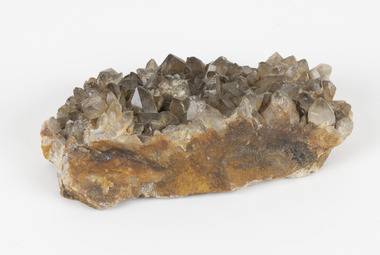
Geological specimen - Smoky quartz crystals, unknown
Quartz is an extremely common mineral to find across the world. Quartz can have two forms; Microcrystalline quartz or Crystalline quartz. Microcrystalline quartz is a fine grain quartz where crystalline quartz is often a large crystal. This specimen is a crystalline quartz. Made of silicon oxide, this specimen is called smokey quartz crystals because of its brownish colour. However, the colour of quartz can vary. In addition, quartz are formed in deep-seated igneous rocks and crystallized through hot aqueous solutions. This type of crystal can be found all over Australia, including Beechworth in Victoria. Other places quartz can be found is the Ashburton River area in Western Australia, Marlborough in Queensland, the Lune River area in Tasmania and Kingsgate in New South Wales. This specimen is significant because it is common to find this kind of mineral. While the location of where this specimen was originally from is unknown, it highlights the many places in Australia where quartz is found. It demonstrates that quartz makes up a large portion of Australia's geology. In addition, quartz itself can vary in its colour and shape. This specimen represents one of these variations. That being smoky quartz crystals. This specimen is part of a larger collection of geological and mineral specimens collected from around Australia (and some parts of the world) and donated to the Burke Museum between 1868-1880. A large percentage of these specimens were collected in Victoria as part of the Geological Survey of Victoria that begun in 1852 (in response to the Gold Rush) to study and map the geology of Victoria. Collecting geological specimens was an important part of mapping and understanding the scientific makeup of the earth. Many of these specimens were sent to research and collecting organisations across Australia, including the Burke Museum, to educate and encourage further study.A large hand-sized quartz mineral with shades of brown and gray throughout.Smoky quartz / crystals /locality/ unknown / (needs a wash) /BBgeological specimen, geology, geology collection, burke museum, beechworth, microcrystalline, quartz, quartz mining, quartz reefs beechworth, smokey quartz crystals, crystals, crystalline, silicon oxide, brown, colour, igneous rocks, magma, ashburton river, western australia, marlborough, queensland, lune river, tasmania, kingsgate, new south wales, nsw -
 The Beechworth Burke Museum
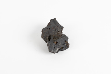
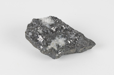
Geological specimen - Hematite (iron oxide)
Hematite is an iron ore significant for its high iron content (70%) and as being one of the two main iron oxide minerals, the other being magnetite. Hematite has a rating of 5-6 on the Moh's hardness scale and is often found as an accessory mineral in many igneous rocks. (an accessory mineral being "any mineral in an igneous rock not essential to the naming of the rock" - Britannica) Hematite has historically been the mainstay of South Australia’s iron ore production. (Magnetite: South Australia’s potential) Making up the eastern section of the Gawler Rangers, the Middleback Range is a mountain range on the eastern side of Eyre Peninsula in South Australia that has been a source of iron ore (its main commodity in minerals) for over a century. (see https://www.mindat.org/loc-22576.html). "Large reserves of high-grade iron ore were identified in 1890 in the Middleback Range, west of Whyalla. From 1915 these ores were shipped to Newcastle and later to Port Kembla, both in New South Wales. Local production of pig iron began when the first blast furnace was opened at Whyalla in 1941, and construction of an integrated iron and steel plant began there in 1958." (Britannica, South Australia: Resources and power). This area is home to 24 mines/mineral deposits (according to mindat.org, thought the Sarig Map provided by SA gov on their Energy and Mining website indicates significantly more mining leases).This mineral specimen was collected from the Middleback Ranges before the area was identified as holding large reserves of iron ore and being commercially mined and is representative of South Australia's significant and ongoing history of iron ore mining, and its contribution to Australia's steel manufacturing industry of the early 20th century (this specimen being collected in the prelude to these events).A small ferric oxide mineral composition a mid-blue-grey in colour with specks of rust-brown throughout.HEMATITE / (iron oxide) / Locality: Middleback Ranges, S. Aust.middleback ranges, iron ore mining, mining, south australia -
 Lakes Entrance Historical Society
Book, Parsons, Max and Trigellis-Smith, Syd, War Memorials of Victoria, 1994
Photographs and descriptions of approximately 1,000 War Memorials in Victoria. Indexed by locality and town.memorials -
 The Beechworth Burke Museum
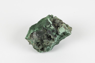
Geological specimen - Malachite, Unknown
Malachite is a copper carbonate hydroxide mineral. It has a chemical composition of Cu2(CO3)(OH)2. It often forms within limestone where a subsurface chemical environment favourable for the formation of carbonate minerals can occur. It is a substance that can be found in many different parts of the world including: Australia, USA, Russia and the Democratic Republic of Congo. Malachite has historically been used to produce copper, with mining of the mineral dating back over a period of four thousand years. Due to its beautiful green colourations, it is also commonly used for aesthetic purposes such as in the production of sculptures and jewellery. This particular specimen was collected from the town of Burra, South Australia as part of a geological survey undertaken during the nineteenth century. The locality (located on Ngadjuri Country) has a long history of mining, particularly in copper mining, as the area is rich in copper deposits. The first significant discovery of this was made in Burra (Burra Burra Mine) in 1845 and, at the time, the mine was the largest and richest of its kind in the world, producing nearly five percent of the total world copper output. This specimen is significant as it is considered to be a rare gemstone, as many of the original deposits for the stones are significantly depleted, leaving behind very few sources. This specimen is part of a larger collection of geological and mineral specimens collected from around Australia (and some parts of the world) and donated to the Burke Museum between 1868-1880. A large percentage of these specimens were collected in Victoria as part of the Geological Survey of Victoria that begun in 1852 (in response to the Gold Rush) to study and map the geology of Victoria. Collecting geological specimens was an important part of mapping and understanding the scientific makeup of the earth. Many of these specimens were sent to research and collecting organisations across Australia, including the Burke Museum, to educate and encourage further study.A solid palm-sized copper carbonate hydroxide mineral with patterns of green colourations Existing Label: MALACHITE / Locality: Burra / S. Aust. Other Label: Confirmed / as Malachite / C. Willman / 15/4/1 / + Bill Birch burke museum, beechworth, geological, geological specimen, malachite, gemstone, green gemstone, burra, burra burra mine, burra south australia, carbonate mineral, copper, copper mining, copper mining burra, carbonate hydroxide mineral, copper carbonate, malachite mining, malachite burra, monster mine -
 Federation University Historical Collection
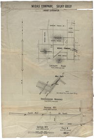
Plan, Midas Company, Sulky Gully near Creswick
Locality and Underground Workings plan for the Midas Company, Sulky Gully near Creswick. Companies shown on the Locality Plan include Dowling Forest No 1., Midas Consols, Madam Midas, Midas Company, King Midas and Midas Extended.dowling forest no 1., midas consols, madam midas, midas company, king midas, sulky gully, creswick, midas extended, cgt -
 Ringwood and District Historical Society
Flyer, Land Sale Brochure, Heathmont Estate, Vic. - circa 1960
Advertisement for sale of residential lots - Heathmont Estate, opposite Heathmont Railway Station, with map and locality plan.Subdivision includes Canterbury Road, Royal Avenue, Coleman Street, Stoda Street, Herman Street, and Campbell Street. Agent - A.W. Dickson, opposite Station, Ringwood. Phone WU6007. -
 Federation University Historical Collection
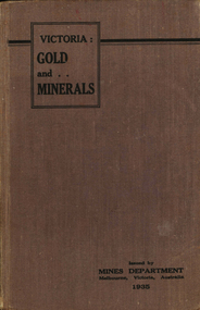
Book, Victoria: Gold and Minerals, 1935, 1935
Hard cover book. Fold out map showing auriferous areas and mineral localities in Victoria, 1935victoria, gold, minerals, 1935, geological map, hydrolic sluicing, panning, pneumatic drill, puddling machine, bendigo, coal mine, wonthaggi, yallourn, jamieson valley, geological school, melbourne university, mount buffalo, electric power station, briquette factory, mines department, george brown, secretary of mines, e.j. hogan, minister of mines, mining -
Whitehorse Historical Society Inc.
Article, Name for East East Burwood, 1969
A new locality name for the far east East Burwood sector of Nunawading will be considered by Council's Works Committee.A new locality name for the far east East Burwood sector of Nunawading will be considered by Council's Works Committee.A new locality name for the far east East Burwood sector of Nunawading will be considered by Council's Works Committee.city of nunawading works committee, suburbs, burwood east -
Lakes Entrance Historical Society
Book, Kenyon, Justine, The Aboriginal Word Book - over 1000 house names to choose from, 1960
Meanings and localities of some Australian Aboriginal words for those who want an Aboriginal word as a name for their house.Ruth Clarkaboriginals -
 Bendigo Historical Society Inc.
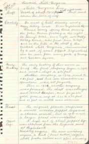
Document - CENTRAL RED, WHITE AND BLUE MINE - LOCALITY AND PLANT OF THE CENTRAL RED, WHITE AND BLUE MINE
Three typed copies of notes on the Central Red, White and Blue Mine. Notes give locality, plant, gold produced and where the gold was obtained from. One copy has 'Typed at Mines Dept' written at the top and has a correction in the locality area. It is signed by A Richardson.mine, gold, central red, white and blue mine, central red, white and blue mine, locality and plant of the central red, white and blue mine, sheepshead line of reef, flying fox, delbridge or mannings shaft, mines dept. booklet 'bendigo goldfield' 1936, annals of bendigo mining sections 1910 - 1936, a richardson -
 Bendigo Historical Society Inc.
Document - CENTRAL NELL GWYNNE MINE - NELL GWYNNE LINE OF REEF
1 handwritten copy, 1 typed copy with corrections and locality map and 1typed copy of the locality, early history revival period, prominence, dividends and gold production. Handwritten copy images 3509.8a,8b,8c Typed copy images 3509.8d,8e,8f,8gmine, gold, central nell gwynne mine, central nell gwynne mine, locality of the central nell gwynne mine, mines dept booklet 'bendigo goldfield' g. brown 1936 -
 Bendigo Historical Society Inc.
Document - NEW CHUM SYNCLINE MINE - NOTES ON THE NEW CHUM SYNCLINE MINE
Typed copy of notes on the New Chum Syncline Mine on the Nell Gwynne Line of Reef. Notes include depth of shaft, years of working, size of lease, locality, plant, best gold and total gold yield. Small locality map attached to front. Albert Richardson Collection.document, gold, new chum syncline mine, new chum syncline mine, notes on the new chum syncline mine, walker & coy bundaberg, cameron & sutherland, little 180, central deborah, mines department booklet 'bendigo goldfield' 1936, mines dept annual and quarterly reports, a richardson -
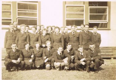 Bendigo Historical Society Inc.
Photograph - JORDAN COLLECTION: PHOTO OF SERVICE PERSONNEL IN UNIFORM
Black and white photo of service personnel. Unknown branch or locality. These people have been posed in front of a building.military, world war 2, airforce personnel -
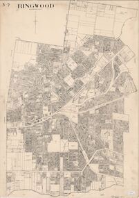 Ringwood and District Historical Society
Map, City of Ringwood - Rateable Properties Layout - c.1966
A0-size (approx) map of named streets, lot-numbered properties and locality features within City of Ringwood boundary. Scale: 8 chains to 1 inch. City Engineer's signature in bottom right corner - Alan Robertson (City Engineer 1958-1987) -
 Ringwood and District Historical Society
Map, Plan of Subdivision - State School Estate, Ringwood East, Victoria - (Undated, circa 1920s)
Map of land for sale attached to green cardboard backing with handwritten notations showing numbered allotments on Dublin Road, Holland Road, King Street, Charles Street and Purser Avenue, Ringwood East.Locality plan includes reference to proposed Ringwood East railway station which opened in 1925. -
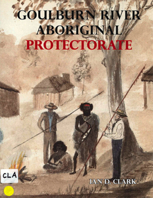 Victorian Aboriginal Corporation for Languages
Book, Ian D Clark, Goulburn River Aboriginal Protectorate : a history of the Goulburn River Aboriginal Protectorate Station at Murchison, Victoria, 1840 - 1853, 2013
This study explains why the locality of what is now known as Murchison is one of the most important historic Aboriginal places in regional Victoria.maps, b&w illustrations, b&w photographs, document reproductionsngurai-illam balug, ngurai-illam wurrung, daungwurrung, yaithmathang, yortayorta, yorta yorta, bangerang, murchison, murnang, george augustus robinson, goulburn river aboriginal protectorate, goulburn river region, victorian history -
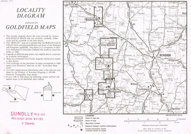 Bendigo Historical Society Inc.
Document - JOAN O'SHEA COLLECTION: LOCALITY DIAGRAM AND NOTES FOR DUNNOLLY GOLDFIELD MAPS
Joan O'Shea Collection. Locality diagram and notes for goldfield maps. Dunolly map set. Wedderburn, Berlin, Dunolly, Maryborough, Avoca.mining, company exploration, dunolly map set. -
Lakes Entrance Historical Society
Book, Smith Dacre, The Lighthouses of Victoria, 1980
Reproduction prints of 40 of the author's painting included in his lighthouses of Victoria exhibition, accompanied by descriptive information of the locality and history of each.lighthouses, arts, literature -
 Bendigo Historical Society Inc.
Photograph - Photos of Bendigo and surrounds, About 1940s
Twenty four small black and white photos of Bendigo Swimming localities, Easter Parade, maybe Spring St in Melbourne and Maryboroughphotos, bendigo, easter parade, swimming pools -
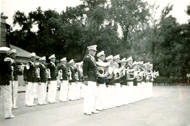
 Bendigo Historical Society Inc.
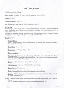
Document - NEW MOON MINE - NOTES ON THE NEW MOON MINE
Four typed copies of notes on the New Moon Mine on the Garden Gully Line of Reef. Notes include locality, depth of shaft, last year of production, size of lease, plant, Telephone and electric signalling, early history, gold obtained, prominence, gold production and dividends. Hand drawn locality map included. Albert Richardson Collection.cottage, miners, new moon mine, notes on the new moon mine, h harkness & coy, thompson & co, telephone & electric signalling, 'robin hood' ground, bendigo amalgamated goldfields co, special edition australian mining standard 1/6/1899, mines dept booklet 'bendigo goldfields' 1936, mines dept annual and quarterly reports, annals of bendigo mining section 1907 = 1931, a richardson, souvenir 'declaration of 200th dividend' issued by directors of new moon co 1/12/1906, mines dept bulletin 47 'structure of bendigo goldfields' h herman 1923 -
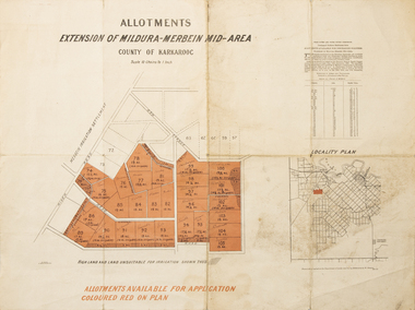 Merbein District Historical Society
Map - Allotments Extension of Mildura-Merbein Mid-Area, Allotments available, 23 November 1920
Allotments available to Discharged Soldiers Discharged Soldier's Settlement Act Historic Large map, folded in 4, coloured map of Merbein indicating allotments available and locality plan. Scale 10 chain to 1 inchPhoto-Lithographed at Department of lands Survey, Melbourne J. Butson 23.11.20discharged soldiers, ww1, soldier settlement, irrigation -
Lakes Entrance Historical Society
Book, Kerrison, Janet, Beaconsfield Gold by Janety Kerrison, 1973
An account of goldmining in the Beaconsfield, Tasmania, locality; the companies and individuals involved, amalgamation of companies, up to the closing of the Tasmania Gold Mine in 1914. Illustrated.mines and mining, settlement, township -
 Bendigo Historical Society Inc.
Document - VICTORIA HILL - VICTORIA QUARTZ, VICTORIA HILL
Handwritten notes on Victoria Quartz, Victoria Hill. Notes mention depth of mine, locality, history, Prominence, and where the best gold was found.document, victoria hill, victoria quartz - victoria hill, victoria reef coy, new chum mines, new chum drainage association -
 The Beechworth Burke Museum
Geological specimen - Galena (with quartz), unknown
Galena is the natural compound of lead and classed as a sulphide, it crystallises in a cubic pattern and its chemical formula is PbS. Galena is a primary source of both lead and silver. This specimen of Galena comes from Broken Hill. Broken Hill has one of the world’s largest and most significant deposit of ore for the production of lead. Mining of Galena at Broken Hill began with the staking of land by Charles Rasp in 1883. By the following year, in 1884, Rasp and six others had formed Broken Hill Mining Company. Broken Hill Mining Company eventually evolved into BHP group limited and is currently the largest mining company in the world and the largest company in Australia. There is archaeological evidence from artefacts discovered in Turkey that humans have been extracting lead from galena by the process of smelting since at least 6500 BCE. This specimen also has quartz on the top surface which is frequently discovered alongside Galena. This mineral specimen is of historic significance as a sample of Galena extracted from Broken Hill during the 19th century. Mining for Galena in Broken Hill begin in 1883 by Charles Rasp and evolved into the world’s largest mining company – BHP Group Limited. Broken Hill is one of the world’s most significant deposits of ore for the production of lead. This specimen is part of a larger collection of geological and mineral specimens collected from around Australia (and some parts of the world) and donated to the Burke Museum between 1868-1880. A large percentage of these specimens were collected in Victoria as part of the Geological Survey of Victoria that begun in 1852 (in response to the Gold Rush) to study and map the geology of Victoria. Collecting geological specimens was an important part of mapping and understanding the scientific makeup of the earth. Many of these specimens were sent to research and collecting organisations across Australia, including the Burke Museum, to educate and encourage further study.A flat, hand-sized, grey sulphide specimen that is the natural compound of lead with a quartz formation on the top surface. Existing Label: GALENA / (with quartz) / Locality: Broken Hill / N.S.W 120 x 70 x 29geological specimen, geology, geology collection, burke museum, beechworth, galena, galena quartz, quartz, charles rasp, broken hill mining company, bhp group limited, bhp, lead, ore, lead sulphide, sulphide, silver, broken hill -
Clunes Museum
Map - MAPS
ORIGINAL MAP SHIRE OF TALBOT AND CLUNES. LOCALITY PLAN, SEALED ROADS, BITUMEN ROADS, GRAVEL OR SAND ROADS, UNMADE OR PART FORMED ROADS.local history, document, maps, talbot, clunes shire -
![M.M.B.W. reticulation plan no. 731, Shire of Blackburn and Mitcham. Locality plan of bores [1933].](/media/collectors/56f368632162f118acbff12e/items/60d923316e5f99545134f002/item-media/636db48a3e324a979b36a333/item-fit-380x285.jpg) Whitehorse Historical Society Inc.
Whitehorse Historical Society Inc.Document, Locality plan of bores, 1933
M.M.B.W. reticulation plan no. 731, Shire of Blackburn and Mitcham. Locality plan of bores [1933]. Scale 1' - 160'. Ref No. S 33/154.whitehorse road, blackburn, surrey road, clare street, francis street, pope road, queen street, albert street, chapel street, bores, melbourne and metropolitan board of works -
Lakes Entrance Historical Society
Book, Loney Jack, Wrecks on the Gippsland Coast, 1968
Shipwrecks and incidents along the coast and in Bass Strait from Point Nepean to Cape Howe. Indexes of Ships and Localities included. Some ship illustrated.A J and H Murrell stamped on first pageshipwrecks, ships and shipping, lighthouses -
Lakes Entrance Historical Society
Book, Tourist Development Authority of Victoria, Victorias 15 National Parks, 1956
This booklet contains a description of the 15 proclaimed Victorian National Parks as at 1956. Illustrated with photographic reproductions and locality map. Historically significant because of the time period.parks, natural history, crown lands, tourism -
 Bendigo Historical Society Inc.
Document - CENTRAL NELL GWYNNE: LOCALITY OF THE CENTRAL NELL GWYNNE
Typed copy of the locality and early history of the Central Nell Gwynne Mine. Includes size and depth of the shaft and where the best gold was found and the total yield.A. Richardsonmine, gold, central nell gwynne mine, central nell gwynne mine, locality of the central nell gwynne mine -
 Bendigo Historical Society Inc.
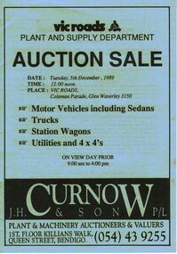
Document - IAN DYETT COLLECTION: AUCTION CATALOGUE - VIC ROADS
Light blue covered auction catalogue with black printing for a sale on 5th December, 1989 at Vic Roads, Glen Waverley. For sale were Motor Vehicles including Sedans, Trucks, Station Wagons, Utilities and 4 x 4's. J. H. Curnow & Son P/L were the auctioneers. Back cover has a map locality and a locality map of the auction area.business, auctioneers, j h curnow & son pty ltd, ian dyett collection - auction catalogue - vic roads plant and supply department, j h curnow & son p/l, bolton bros pty ltd