Showing 2633 items
matching map of victoria
-
 Bendigo Historical Society Inc.
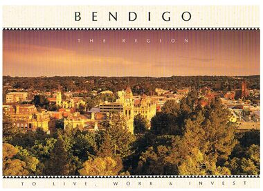
Book - BENDIGO - THE REGION TO LIVE, WORK & INVEST
... Map of Victoria... picture, they are:- Hargreaves Mall, Eaglehawk Golf Course, Map... Golf Course Map of Victoria La Trobe University Big Hill ...Pale yellow 12 page book titled 'Bendigo the Region to Live Work & Invest'. On the front cover is a scenic view of Bendigo and on the back cover a picture of some quartz and gold nuggets on a green background. Sections in the book are: Live Work & Invest, Lifestyle, Access, Community, Infrastructure, Labour Force, Business, Opportunity, Successes and Information. Each page has a colour picture, they are:- Hargreaves Mall, Eaglehawk Golf Course, Map of Victoria, La Trobe University, Big Hill, Regional Office Department of Planning & Development, Sandhurst Farms, Construction Activity, Products of the Region, Dr. Ian Macbean, Mr Evan Jones and the Capital Theatre with information on each.book, bendigo, bendigo, bendigo - the region to live, work & invest, bendigo regional development board, dr ian macbean, mr evan jones, kate mildren, richard gibbs, express printers, hargreaves mall, eaglehawk golf course, map of victoria, la trobe university, big hill, regional office department of planning & development, sandhurst farms, construction activity, products of the region, capital theatre -
 Federation University Historical Collection
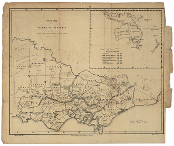
Map, Robert Brough Smyth, Sketch Map of the Colony of Victoria, c1871, c1872
... Sketch Map of the Colony of Victoria, c1871... of the Colony of Victoria, c1871 Map Robert Brough Smyth ...This map includes the population of each County in Victoria according to the 1871 Census, as well as the population of each Australian colony and New Zealand. Telegraph Route is given in a detail at the top right. victoria, victorian counties, robert brough-smyth, telegraph, population, bourke, rodney, dalhousie, evelyn, mornington, buln-buln, tanjil, dargo, delatite, moira, bogong, bendigo, gunbower, grant, talbot, hampden, heytesbury, polwarth, ripon, kara-kara, gladstone, grenville, croajingolong, tambo, benambra -
 Rutherglen Historical Society
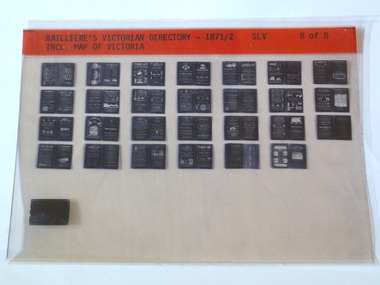
Microfiche, Bailliere's Victorian Directory 1871/2, 1871/72
... SLV Incl. Map Of Victoria...-country A directory in Victoria town names victoria Map SLV Incl ...A directory in Victoriasmall sheet of film SLV Incl. Map Of Victoriatown, names, victoria, map -
 Ballarat Heritage Services
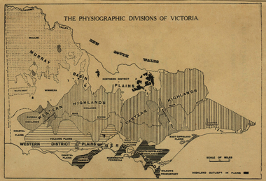
Map, Physiographic Divisions of Victoria, c1940, c1940
... Physiographic map of Victoria... Office goldfields victoria map physiography Physiographic map ...Physiographic map of Victoriavictoria, map, physiography -
 Glenelg Shire Council Cultural Collection
Souvenir - Spoon - Commemorative Victoria 150th, n.d
... Spoon commemorative Victoria 150th with map of Victoria.... Victoria 150th with map of Victoria. Souvenir Spoon - Commemorative ...Spoon commemorative Victoria 150th with map of Victoria. -
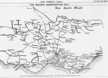 Ringwood and District Historical Society
Photograph, Map showing Victoria's proposed railway system, 1890
... Catalogue card reads, 'Map showing Victoria's proposed... showing Victoria's proposed railway system, 1890. Map showing ...Catalogue card reads, 'Map showing Victoria's proposed railway system, 1890. -
Stawell Historical Society Inc
Photograph - Mining Scene, Close up
... Sepia Print Mining Scene, map of Victoria marking Stawell... Mining Scene, map of Victoria marking Stawell Close up Photograph ...See Holtman Panarama photo 2Sepia Print Mining Scene, map of Victoria marking Stawellmining, stawell -
 Nhill Aviation Heritage Centre
Map - Aeronautical Maps x 9, May 1943
... Aeronautical maps of Victoria, Printed on light card green... scale 1:1000,000 Aeronautical maps of Victoria, Printed on light ...Typical of the maps used during navigation training here at Nhill during WW2Aeronautical maps of Victoria, Printed on light card green text and markingsThird Edition May 1943, Sheet K8, Australian Aeronautical Map, Equatorial scale 1:1000,000map, aeronaughtical map, navigation -
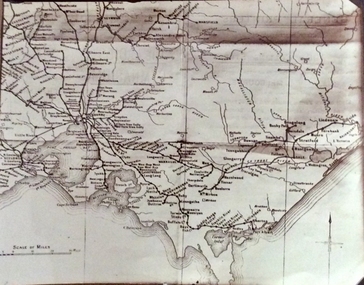 Phillip Island and District Historical Society Inc.
Photograph, Rail Lines of Victoria, Early to mid 20th century
... Sepia photo of map of Victoria showing rivers and railway...-island-and-the-bass-coast Map showing extensive railway network ...Map showing extensive railway network in Victoria in early C20th.Sepia photo of map of Victoria showing rivers and railway lines and stations.Names of towns, rivers, bays etcsepia photograph, rail transport, victoria, map -
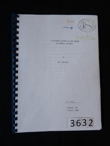 Stawell Historical Society Inc
Book, R.B. Watchorn, A Pictorial History of Gold Mining at Stawell Victoria - Previously Cat No 3632, 06 April 1986
... White Paper cover with map of Victoria inside two oval... Mining at Stawell, Victoria By R.B. Watchorn R Watchorn ...Photos and extracts from the proposed new pictorial history of gold mining in Stawell. PLEASE NOTE: This book is not very accurate, lots of mistakes.White Paper cover with map of Victoria inside two oval rings.A Pictorial History of Gold Mining at Stawell, Victoria By R.B. Watchorn R Watchorn (Signature) Stawell, Vic 6 April, 1986stawell -
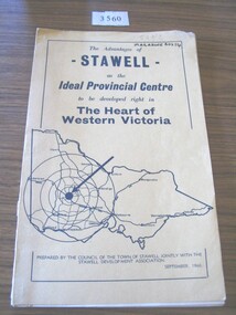 Stawell Historical Society Inc
Book, Council of the Town of Stawell, The Advantages of Stawell as the Ideal Provincial Centre, 1966
... Tan card cover with black border inside of which is a map... with black border inside of which is a map of Victoria The Advantages ...Tan card cover with black border inside of which is a map of VictoriaThe Advantages of Stawell as the Ideal Provincial Centre to be developed right in the heart of Western Victoria. Prepared by the Council of the Town of Stawell Jointly with the Stawell Development Association September1966stawell tourism -
 Victoria Police Museum
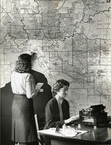
Photograph (Auxiliary police)
... Auxiliary Police woman looking at a traffic map of Victoria... Police woman looking at a traffic map of Victoria at D24 ...Taken from an album of various police departments at Russell Street. Auxiliary Police woman looking at a traffic map of Victoria at D24 in Russell Street.police women, d24, russell street, women's police auxiliary force, police woman, policewomen, policewoman -
 Federation University Historical Collection
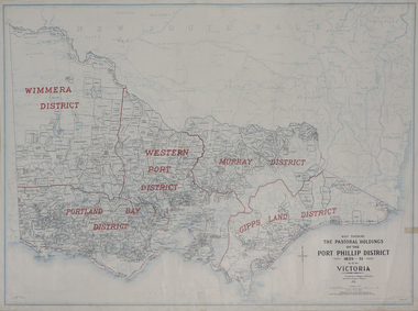
Plan, Map Showing the Pastoral Holdings of the Port Phillip District 1835-1851 Now Victoria, 1932, 1932
... Map of Victoria showing the boundaries of the Port Phillip... (Victoria) pastoral boundaries. Map Showing the Pastoral Holdings ...Another name for Pastoral Holdings is squatting runs. Information on Alfred Stephen Kenyon of the Historical Society of Victoria can be found at http://adb.anu.edu.au/biography/kenyon-alfred-stephen-6936/text12035 Map of Victoria showing the boundaries of the Port Phillip District (Victoria) pastoral boundaries. pastoral holdings, squatters, squatting, victoria, land, crown lands, a.s. kenyon, alfred stephen kenyon -
 Bendigo Historical Society Inc.
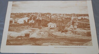
Photograph - Photograph of New Chum Line of Reef
... : Bendigo gold project. A small map of Victoria is also printed.... A small map of Victoria is also printed on the back. Sepia ...BHS CollectionSepia coloured print of a photograph of the New Chum Line of Reef looking south from the Snobs Hill group of mines. The photo shows several poppet heads and chimneys, bridges and houses. New Chum Line of Reef. includes Victoria Hill possibly the richest spot on the field.On the back a drawing of a poppet head with the words: Bendigo gold project. A small map of Victoria is also printed on the back. bendigo mines, new chum line of reef, mining -
Federation University Historical Collection
Map, Aboriginal Language Areas in Victoria: A Reconstruction
... A4 sized map of Victoria showing Aboriginal Langauge Areas... Aboriginal Aboriginal Language Victoria Djadja Wurrung Woi Wurrung ...A4 sized map of Victoria showing Aboriginal Langauge Areas. Black, white and red writing aboriginal, aboriginal language, victoria, djadja wurrung, woi wurrung, watha wurrung, gadubanud, girai wurrung, dhauwurd wurrung, djab wurrung, wiradjuri, tatungalung, wadiwadi, dadidadi, yuyu -
Whitehorse Historical Society Inc.
Article, Aboriginal tribal boundaries of Victoria, n.d
... Map of Victoria showing tribal names and boundaries... Mitcham melbourne Aborigines Christian Action Committee Map ...Map of Victoria showing tribal names and boundaries in Victoria with comment on activities of the Christian Action Committee.Map of Victoria showing tribal names and boundaries in Victoria with comment on activities of the Christian Action Committee.Map of Victoria showing tribal names and boundaries in Victoria with comment on activities of the Christian Action Committee.aborigines, christian action committee -
Marysville & District Historical Society
Map (item), Taungurung Land and Waters Council Aboriginal Corporation, Unknown
... A map of the area in Victoria which is the land...A map of the area in Victoria which is the land... in Victoria which is the land of the Taungurung Clan. A map ...A map of the area in Victoria which is the land of the Taungurung Clan.A map of the area in Victoria which is the land of the Taungurung Clan. Taungurung Land and Waters Council (TLaWC) was registered 16 July 2009 as the Registered Aboriginal Party that represents the interests of the Taungurung people. TLaWC is the corporate representative and ‘face’ of the Taungurung people and serves to uphold their interests with respect to culture and country. The Taungurung people occupy much of central Victoria. Their country encompasses the area between the upper reaches of the Goulburn River and its tributaries north of the Dividing Range. From the Campaspe River to Kilmore in the West, eastwards to Mount Beauty, from Benalla in the north down to the top of the Great Dividing Range, their boundaries with other Aboriginal tribes are respected in accordance with traditional laws.taungurung clan, taungurung land and waters council aboriginal corporation, victoria -
 Stanley Athenaeum & Public Room
Administrative record - Old bank books, Bank Books - Athenaeum Committee No.610-01346
... with picture of map of Victoria on front cover.... with light blue/dark blue covers with picture of map of Victoria ...State Bank books with light blue/dark blue covers with picture of map of Victoria on front cover.State Bank of Victoria - 26 Jan 1972 - 12 Jun 1974. Transactions for 'Athenaeum Committee Stanley' -
 Stanley Athenaeum & Public Room
Administrative record - Old bank books, Bank Books - Athenaeum Committee No.610-01346
... with picture of map of Victoria on front cover.... with light blue/dark blue covers with picture of map of Victoria ...State Bank books with light blue/dark blue covers with picture of map of Victoria on front cover.State Bank of Victoria - 12 Jun 1974 - 16 Jul 1976. Transactions for 'Athenaeum Committee Stanley' -
Tatura Irrigation & Wartime Camps Museum
Invitation, Tatura the heart of the Goulburn Valley, 1944
... Cream card title on front, map of Victoria. Tatura shown... woollen textile centre Cream card title on front, map of Victoria ...Invitation to Hon. J. H. Lienhop MLC to open the Industry of Haworth, Thomas and James Woollen textile Centre in Tatura Manufacturing Co. 18 November 1944. Included list of names and photo copies of all.Cream card title on front, map of Victoria. Tatura shown on back and hand written signatures surrounding it. j. h. lienhop, haworth, thomas and james woollen textile centre -
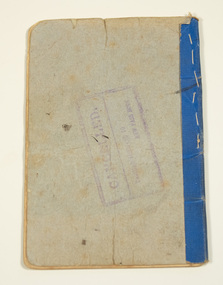
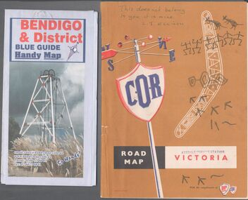 Bendigo Historical Society Inc.
Map - Road maps
... the other a road map of Victoria. .... On the Victoria map the words in pen "This doesn't belong to you... Collection Road Map Victoria Bendigo On the back of the Bendigo map ...BHS CollectionTwo road maps. On, Bendigo & District blue guide handy map the other a road map of Victoria. On the back of the Bendigo map the date October 2000. On the Victoria map the words in pen "This doesn't belong to you, it is mine". L.J. Ellison and a blue stamp of Axedale service station. Aileen and John Ellison Collection.road map, victoria, bendigo -
Glenelg Shire Council Cultural Collection
Photograph - Photograph -Port of Portland office, n.d
... Black & white photo of a wall map of Victoria, with lines... Authority Archives Port of Portland Archives offices map Victoria ...Port of Portland Authority ArchivesBack: White Sticker ---Trade Fair 61-67 - black biroport of portland archives, offices, map, victoria -
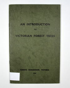 Marysville & District Historical Society
Book - Paperback book, An Introduction to Victorian Forest Trees, 1961
... cover. On the inside back cover is a map of Victoria... on the front cover. On the inside back cover is a map of Victoria ...A history of forestry in Victoria Paperback. Cover is green with only the title on the front cover. On the inside back cover is a map of Victoria with the state forests indicated.Stamp of Marysville & District / Historical Society Inc / P.O. Box 22 / Marysville 3779victoria, forestry, forest, trees -
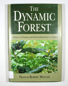 Marysville & District Historical Society
Book - Hardback book, The Dynamic Forest-A History of Forestry and Forest Industries in Victoria, 1991
... undergrowth. Front end paper shows a map of Victoria detailing... of Victoria in the year 1869. Back end paper shows a map of Victoria ...A history of forestry and forest industries in VictoriaHardback. Green dust cover with photograph of forest undergrowth. Front end paper shows a map of Victoria detailing forested and non-forested areas in the State of Victoria in the year 1869. Back end paper shows a map of Victoria detailing forested and non-forested areas in the State of Victoria in the year 1987. To Jean, who bore the/ brunt of it all - and to/ Jan, Rob, Sue and Andy Stamp of the Marysville & District Historical Society Inc / P.O. Box 22 / Marysville 3779forests, forestry, forest products industry, victoria, history, moulds, francis robert -
 Marysville & District Historical Society
Book, Picturesque Victoria, 1908
... sitting on railway tracks. There is a fold-out map of Victoria... on railway tracks. There is a fold-out map of Victoria in the middle ...Paperback. Front cover has an illustration of a steam train sitting on railway tracks. There is a fold-out map of Victoria in the middle of the book.Stamp of Marysville & District / Historical Society Inc / P.O. Box 22 / Marysville 3779victorian railways, tourism, history, victoria -
Lakes Entrance Historical Society
Book, P D Gardner, Names of the Great Alpine Road between Bairnsdale and Omeo, 1990c
... with photographs drawing and maps Bairnsdale Victoria... and maps Bairnsdale Victoria Names of the Great Alpine Road between ...Some of the place names appearing on the road between Bairnsdale and Omeo and explanation of their meanings illustrated with photographs drawing and maps Bairnsdale VictoriaSigned by author Peter Gardnertownship, social history -
 Yendon History Group
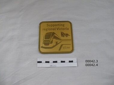
Boxed set of four (4) coasters - coaster 3
... . Embossed with a picture of a modern intercity train and a map... of a modern intercity train and a map of Victoria. Identical ...Part of the contents of a souvenir gift bag given to those who rode on the re-enactment train for the 150th anniversary of the Geelong to Ballarat railway on 10 April 2012.Gold aluminium coaster, backed with royal blue felt. Embossed with a picture of a modern intercity train and a map of Victoria. Identical to coaster 4Supporting regional Victoria / V/Linegeelong ballarat railway, railway 150th anniversary -
 Yendon History Group
Boxed set of four (4) coasters - coaster 4
... . Embossed with a picture of a modern intercity train and a map... intercity train and a map of Victoria. Identical to coaster 3. Boxed ...Part of the contents of a souvenir gift bag given to those who rode on the re-enactment train for the 150th anniversary of the Geelong to Ballarat railway on 10 April 2012.Gold aluminium coaster, backed with royal blue felt. Embossed with a picture of a modern intercity train and a map of Victoria. Identical to coaster 3.Supporting regional Victoria V/Linegeelong ballarat railway, railway 150th anniversary -
 Tatura Irrigation & Wartime Camps Museum
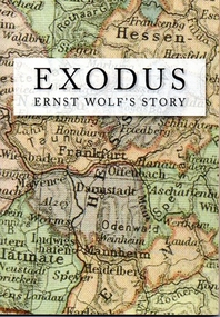
Book, Exodus. Ernst Wolf's story, 2012
... of Germany superimposed on cover. Map of Victoria superimposed... cover with a map of Germany superimposed on cover. Map ...Author Ernst Wolf was an internee who arrived in Australia aboard the Dunera. 68 pages, B&W and colour photos. Soft cover with a map of Germany superimposed on cover. Map of Victoria superimposed on back cover.Celebrating the 90th birthday of Ernst Wolfe, December 30th, 2011, and for the Wolfe family everywheredunera, ernst wolf, exodus -
 South Gippsland Shire Council
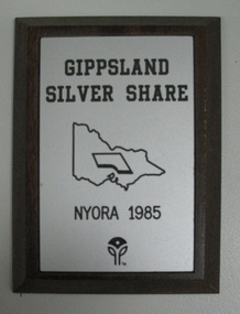
Plaque, Gippsland Silver Share
... . Features a map of Victoria in the centre and logoat bootom edge.... Features a map of Victoria in the centre and logoat bootom edge ...Wood plaque with silver engraved plate affixed to front. Features a map of Victoria in the centre and logoat bootom edge. Dark polished timber.