Showing 1699 items matching "maps and documents"
-
 Victorian Aboriginal Corporation for Languages
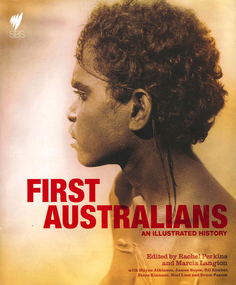
Book, Rachel Perkins, First Australians : an illustrated history, 2008
"A landmark history of Indigenous Australia which accompanies a major nine part Australian television series. It combines the most rigorous academic research with capitvating contemporary story-telling. Richly illustrated book that includes images of the landscape, evocative ninteenth-century photography and Aboriginal art. Written by Australia's leading Indigenous historian and public intellectuals"--Provided by publisher.maps, document reproductions, b&w illustrations, colour illustrations, colour photographs, b&w photographscolonisation, race relations, australian aboriginal history, pictorial histories -
 Peterborough History Group
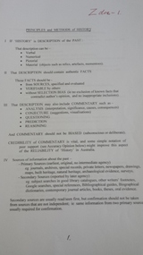
Document - Principles and Methods of History, Principles and Methods of History, Aboriginal Clans and Language
Academic description of Ken Clements' approach to research. Aboriginal clan informationPrinted A4 document, photocopied mapsbaradh clan, girai wurrung, peterborough 3270 -
 Peterborough History Group
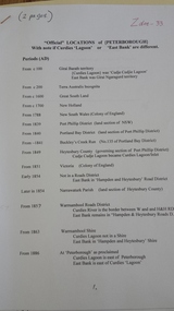
Document - Names of town and locations
copy of gazetting of the town, history of names within the district, history of the street names in PeterboroughPhotocopied pages, map, typed documents -
 Glen Eira Historical Society
Map - CAPLES PLACE SUBDIVISION
... Documents ...This file contains a copy of a map of the CAPLES PLACE SUBDIVISION, undated and author unknown. The map provides the dimensions of roads and allotments in the area, including also handwritten notes from the original document and others written directly onto the copy.land subdivisions, documents, maps, glen eira, caples place, caples place subdivision, land surveys, orrong road, mulgrave road, prahran grove, somerset road, prahran grove, prahran grove, east walk, land allotments, town planning, garden road -
Greensborough Historical Society
Report, Melbourne Parks and Waterways, Happy Hollow Farm Complex : Conservation Strategy [excerpts], 1996_07
This report was commissioned by the Melbourne Parks and Waterways in 1996. It contains a history of the place and building, and garden and landscape features. There is a Statement of Cultural Heritage Significance. Happy Hollow was occupied (and probably built) by Emmett Whatmough in 1893, and owned by John Cully McLaughlin. There are other family connections among the Greensborough district pioneers.Copy of document, 16 pages plus maps.happy hollow, whatmough, bell, mclaughlin, melbourne parks and waterways. cultural heritage significance -
Clunes Museum
Map
... DOCUMENTS ....1 - .4 DETAILED MAP OF CLUNES BY F.C.W. .5 MAP OF CLUNESlocal history, documents, maps, maps -
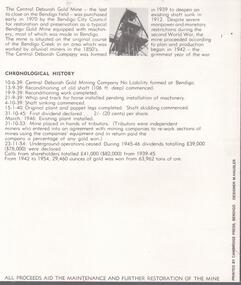
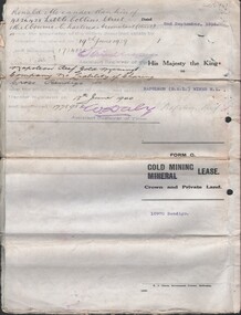
 Bendigo Historical Society Inc.
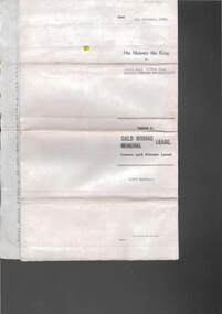
Document - MCCOLL, RANKIN AND STANISTREET COLLECTION:SOUTH NELL GWYNNE GOLD MINING COMPANY NO LIABILITY, 1940
Document: South Nell Gwynne Gold Mining Company No Liability - gold mining lease document no. 11074 Bendigo. Document of 3 pages with map insert.organization, mining, south nell gwynne gold mining co., bendigo, mccoll, rankin & stanistreet -
National Vietnam Veterans Museum (NVVM)
Memorabilia, Memorabilia of Neil Ernest Swainston
Contains photocopies of his Army documents & 6 microfiche of contour maps (?)vietnam war, 1961-1975 - personal narratives - australian -
 Heidelberg Golf Club
Book, Melbourne Parks and Waterways, Lower Plenty River concept plan: Maroondah Pipe Track to Yarra River, 1994
Lower Plenty River concept plan: Maroondah Pipe Track to Yarra River. Includes suggestion of Plenty River Trail along the west boundary of the Heidelberg Golf Club.66 p., illus., colour map. Also, Draft copy of document.plenty river trail, lower plenty river, heidelberg golf club, mmbw, melbourne parks and waterways -
 Bendigo Historical Society Inc.
Document - MCCOLL, RANKIN AND STANISTREET COLLECTION: GOLD MINING LEASE, 1937
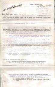
Document: McColl, Rankin and Stanistreet: document - gold mining lease document, 3 pages with map. Map adjoins Upper California Gully Road. Sheaf of 5 letters attached to inside of document with pin. Lease between Herbert Jackson Leed of Bendigo and State of Victoria. No. 10901, Vol 320 Fol 35364.organization, mining, gold mining lease, mccoll, rankin and stanistreet: herbert jackson leed, gold mining lease -
 Bendigo Historical Society Inc.
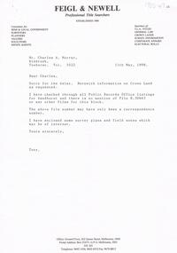
Document - BHS ADMINISTRATION COLLECTION: TITLE SEARCH DOCUMENTS, 1998
Title search documents for Dudley House 1998. Documents and maps relating to a title search instigated by Charles Murray on behalf of the BHS . -
 Bendigo Historical Society Inc.
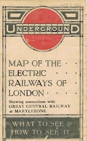
Document - ROBERT DENIS KELLY COLLECTION: MAP OF ELECTRIC RAILWAYS OF LONDON
Document: map of the electric railways of London. Buff coloured document, printed in black, white and red on front cover. Folds into 9 x 14 map. Details include tourist destinations, descriptions of costs etc.Johnson, Riddle & Co. Ltd. London.person, robert denis kelly, world war 1, france, london, underground, electric railway -
Tatura Irrigation & Wartime Camps Museum
Document, Geological Plan, Eildon Dam Site, 1945
... documents ...To record details of geological aspects of EildonA series of maps illustrating rock formations etc., locations, boundaries and planswater/irrigation, documents, maps -
Clunes Museum
Document - FOLDER
FOLDER OF OLD SHIRE MAPS AND DOCUMENTS TALBOT AND CLUNES SHIRE, ETC, ETC.local history, folder, shire of talbot and clunes -
 Bendigo Historical Society Inc.
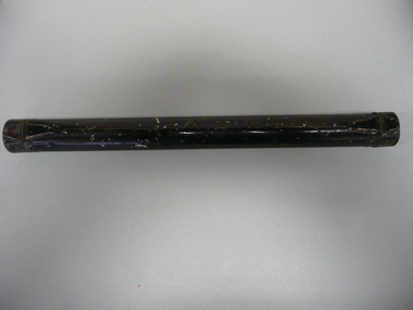
Accessory - METAL CYLINDER
Metal cylinder for storing map or documents with hinged lid on both ends, painted black.domestic equipment, containers, document -
 Bendigo Military Museum
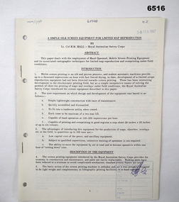
Administrative record - Royal Australian Survey Corps - A simple silk screen equipment for limited map reproduction by LTCOL HM Hall (RASvy) 1967, LtCol HM Hall (RASvy), 6 Feb 1967
This paper deals with the employment of Hand operated Mobile Screen Printing Equipment and its associated cartographic techniques for limited map reproduction and overprinting under field conditions. Written by LtCol HM Hall (RASvy)8 x A4 page document containing typed text, photos and map extractroyal australian survey corps, rasvy, fortuna, army survey regiment, army svy regt, asr, school of military survey, sms -
 Bendigo Historical Society Inc.
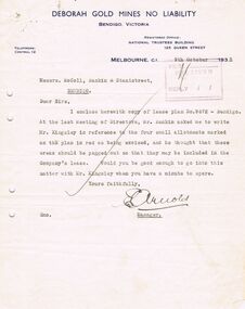
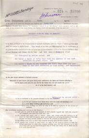
Document - MCCOLL, RANKIN AND STANISTREET COLLECTION: DEBORAH GOLD MINE NL - LEASE DOCUMENTS, 1935, 1941
Document: McColl, Rankin and Stanistreet: lease documents. 12 pages of lease details, with attached map plan on no 9672 Bendigo. ( Abel and Eve Street marked )organization, mining, deborah gold mines nl, mccoll, rankin and stanistreet: deborah gold mines nl, gold mining, lease -
 Bendigo Historical Society Inc.
Document - MCCOLL, RANKIN AND STANISTREET COLLECTION: HERBERT JACKSON LEED OF BENDIGO, 1 April 1941
Document Herbert Jackson Leed document gold mining lease, Vol. 325 Fol. 35900, dated 1 April 1941. 4 page document with attached map and one unattached page. Map shows area in state Forest, Parish of Mandurang. Lease between Herbert Jackson Leed and State of Victoriaorganization, mining, gold mining lease, herbert jackson leed of bendigo, gold mining lease -
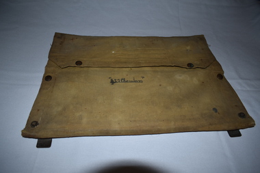
 Bendigo Military Museum
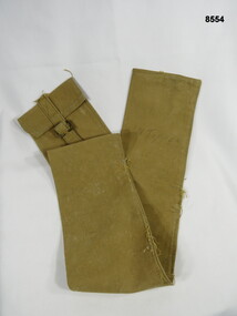
Equipment - CARRY BAG, Unknown
Long narrow khaki holdall carry bag, most likely used to carry maps or documents.N. TUPPERpasschendaele barracks trust, holdall, carry bag -
 Bendigo Historical Society Inc.
Document - CENTRAL DEBORAH GOLD MINE: COMPLIMENTARY GUIDE TO THE CENTRAL DEBORAH GOLD MINE
BHS CollectionBlack and white bifold document, on front of document 'Complimentary guide to the Central Deborah Gold Mine'. Inside is a map and numbered features of the mine site with interpretive information.bendigo, mining, central deborah gold mine -
 Dandenong/Cranbourne RSL Sub Branch
Functional object - Canvas document satchel
Canvas document folder with metal frame. Contents include maps of Gembrook ( Victoria ) and Shoalwater Bay ( Queensland ).Name inscribed on front " L . Chambers." -
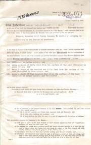 Bendigo Historical Society Inc.
Document - MCCOLL, RANKIN AND STANISTREET COLLECTION: DEBORAH EXTENDED GOLD MINING COMPANY N/L GOLD MINING LEASE, 18 April 1957
Document Deborah Extended Gold Mining Company N/L document - gold mining lease document, Vol 334 071, dated 18 April 1957, 4 pages with map. Map adjoins Bendigo Cemetery. Lease between Deborah Extended Gold Mining Company N/L and the State of Victoria. No. 11339, Vol 334 Fol 071.organization, mining, gold mining lease, deborah extended gold mine, gold mining lease -
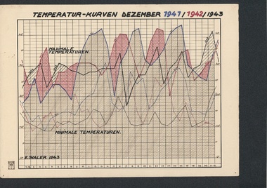 Tatura Irrigation & Wartime Camps Museum
Folio, Loveday & Camp 1 Temperature & Wind records, 1942-45
... documents ...Records taken and graphed while in internment at Loveday and Tatura. Sketches and story were done in Camp 3, TaturaBlue plastic folder and sleeves containing 10 graphs, and nineteen coloured pen and ink and colour sketches and story of young children in Camp 3ww2 camp 3, loveday, documents, maps -
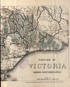 Federation University Historical Collection
Map - Map and Information, Department of Mines: Map and Suggestions to Prospectors, 1891
The map outlines the auriferous (gold bearing) areas in Victoria. The information for prospectors was prepared by the Department of Mines in 1894Document: 4 page type written Map: Portion of Victoria divided into Counties of 1891. Auriferous areas with red.Reference section on mapgold, auriferous areas, department of mines, victoria, map of victoria, prospectors, commissioner of crown lands, hon a mclean, alexander black, surveyor general, a mclean -
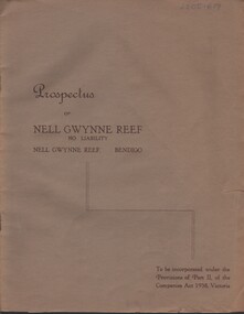 Bendigo Historical Society Inc.
Document - MCCOLL, RANKIN AND STANISTREET COLLECTION: NELL GWYNNE REEF N/L - PROSPECTUS, 1938
Document. Slim, stapled Greybrown book. Nell Gwynne Reef N/L Prospectus. Contains underground maps.McColl, Rankin & Stanistreetorganization, business, nell gwynne reef mine, mccoll, rankin & stanistreet, nell gwynne reef n/l, gold mining, prospectus -
 Melbourne Tram Museum
Map, Melbourne & Metropolitan Tramways Board (MMTB), MMTB Route Maps, 1979
... MMTB Route Maps...maps ...Series of colour maps for various tram and bus routes, dated 1979. Also contained, not scanned are letters, reports, and specifications for printing these maps for use in shelters etc. Some have the Transport Information Centre telephone printed on them. Some are finished with a plastic laminate finish on either one or both sides. Show the major cross streets, parks, schools, other tram routes, major stop numbers, and railway lines. See also item 3909 for another example of these. Trams 1 - City route guide - R9/77 - showing all route numbers and destinations that passed through the CBD. 2 - Bourke St tram routes - R4/77 - East Brunswick Blyth St and East Preston Tyler St and intermediate routes, routes 95, 96, 97, 90, 89 and 88. 3 - Malvern, East Malvern, Carnegie, and East Brighton Tram Routes (from St Kilda Junction) - R1/79 - shows routes 5, 3, 67, 66, 61, 62, and 64. 4 - Elizabeth St tram routes - R12/77 - Essendon Airport, West Maribyrnong, North Coburg lines, routes 50, 58, 60, 54, 57, 52. 49, 59, 18, 20 and 19 5 - Flinders St tram routes - R5/78 - North Balwyn, East Burwood, routes 48, 40, 41, Hartwell, 28, 74 and 75 6 - Kew - St Kilda Beach - R1/79 - Route 69. 7 - Mont - Albert City - R11/77, shows routes 43. 47. 45. 44 8 - St Kilda Rd Tram Routes R12/77 - details South Melbourne Beach, route 1 and route 2 and St Kilda Beach routes 15, 16, and 55 otherwise shows where the various routes branch off St Kilda Road 9 - Batman Ave tram routes - R9/77 - Wattle Park, North Richmond and Prahran - routes 70, 71, 78 and 79. 10 - Footscray - Moonee Ponds - R3/81 - Route 82 11 - Swanston St tram guide - R1/79 - lists all routes and route numbers that branch or cross Swanston St between Grattan St and St Kilda Junction. 12 - Toorak Camberwell and Glen Iris tram route with Camberwell Junction and Malvern Town Hall, R1/79, routes 8, 7, 6, 72, and 73 shown. 13 - West Preston - Beach tram routes - R12/77 - routes 10, 11, 9 and 12, 14 - William St tram routes - R12/77 - Route 55, 56, and 63 - South Melbourne Depot and Domain. Buses 1 - Footscray, Sunshine, Deer Park, Nth Altona & Fishermans Bend - R2/79 2 - Box Hill bus routes to Templestowe, Heidelberg & East Kew - R6/78 - notes superseded by R3/82 3 - Plan of Russell St Melbourne bus departure bays. 4 - Box Hill, Mitcham & Ringwood bus routes to East Doncaster & Warrandyte - R3/82 5 - City - Warrandyte & East Doncaster bus routes - R3/82 & R6/78 6 - Bulleen - City - Port Melbourne - Garden City Bus route - R6/78 7 - North Altona - City bus route - 11/78 8 - Clifton Hill - Elsternwick - R2/79 9 - La Trobe - Northland - West Heidelberg - City Bus Service via East Freeway - 11/79 and R3/81 10 - Box Hill, Mitcham & Ringwood Bus Routes to East Doncaster & Warrandyte - R10/84 - with the Metropolitan Transit logo.Yields information about tram and bus routes in late 1970s early 1980s.Book - brown comb binding, card and clear plastic covers containing both bound and unbound maps and documents.K C Painter on front cover in ink.tramways, mmtb, tram routes, maps, bus routes, route numbers, routes, route guide -
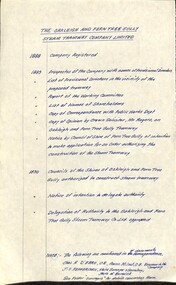 Melbourne Tram Museum
Document - Research Notes, H. S. McComb, "The Oakleigh and Ferntree Gully Steam Tramway Company Limited", 1960's?
Handwritten timeline on foolscap paper, titled "The Oakleigh and Ferntree Gully Steam Tramway Company Limited", giving years and events and reference documents with reference on the second page to a sketch plan from various documents. Dates 1888 to 1890. Map not with document.trams, tramways, steam trams, oakleigh, ferntree gully -
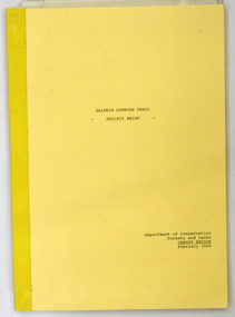 Orbost & District Historical Society
document, BALDWIN SPENCER TRAIL Project Brief 1988, February 1988
This document was produced by the Department of Conservation, Forests & Land Management, Orbost, to commemorate the visit by Baldwin-Spencer in 1989 as part of the Bicentennial Walking Tracks Project. The Baldwin Spencer Trail closely follows the route of scientist and explorer William Baldwin Spencer. Sir Walter Baldwin Spencer KCMG (23 June 1860 – 14 July 1929) was an English-Australian biologist and anthropologist. this booklet is a useful reference tool.A document of 10 pp with a cream cover, titled, Baldwin Spencer Trail Project Brief Feb 1988. It contains mapsbaldwin-spencer -
 Bendigo Historical Society Inc.
Document - MCCOLL, RANKIN AND STANISTREET COLLECTION: NAPOLEON REEF GOLD MINING CO. N.L, 1938
5 Page Legal Document with map of lease area, 6 land application forms (see attached pdf for details).organization, business, industrial - mining, mccoll rankin & stanistreet, mining, gold mining, napoleon reef -
Whitehorse Historical Society Inc.
Document - Land Auction and History, Trove Park Drive, Vermont, 1969
Subdivisional land auction documents for Trove Park Drive off Terrara Road, Vermont and history of the site, including maps and photographs.Subdivisional land auction documents for Trove Park Drive of Terrara Road, Vermont and history of the site, including maps and photographs.non-fictionSubdivisional land auction documents for Trove Park Drive off Terrara Road, Vermont and history of the site, including maps and photographs.trove park drive estate vermont, trove park drive vermont, terrara road vermont, uplands vermont, chris round, murray round