Showing 41 items
matching measuring angles
-
 Myrtleford and District Historical Society
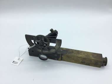
Inclinometer, Early 20th Century
Provenance not clear. Leather case has 'MMBW' inscribed in black pen, indicating an association with Melbourne Metropolitan Board of Works. Item has been in the possession of Terry McCormack since 1972Hand held brass pocket inclonometer level, circa 1920. Leather case for safe storage. Semi circular graduated dial with 90 degree vernier scale with a small (20mm) magnifying glass to aid reading the vernier scale. Above the body, mounted at the rear of the graduated dial, is a spirit level tube which is tilted by finger movement to the milled hand wheel. The height to be determined is sighted through the instrument eyepiece and the bubble tube is tilted until the bubble, viewed in the mirror inside the sighting tube, is brought level with the graticule sighted at the top of the subject object. An angle is thus obtained and by measuring the distance on the ground to the object, trigonometry can be applied to determine the height of the object.Herga & Co. BRISBANE. Made in England -
 Numurkah & District Historical Society
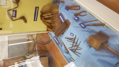
Carpentry Tools & Storage Box
These carpentry items were owned and used by Archibald (Mick) Blackley, a local long-time resident of Numurkah. Born 1912 in Numurkah, Mick was the son of Archibald (Senior) and Grace Blackley, also residents of Numurkah. Archie Senior was a carter, horse-breaker, conducted a livery stable and worked at Brown Corke & Co for a number of years. Archie also served in the Veterinary Corps in WW1. Some of the tools donated belonged to Archie Senior eg wooden hand planes. Mick Blackley used his dad’s tools (and also added some of his own) when he worked in various carpentry jobs during the 1930’s and 1940’s. One particular carpentry job was during the depression when Mick relocated to the Wonthaggi State Coal Mines building stables for the horses, and also completing some building works inside the mines. Returning to Numurkah, Mick joined a Mr Murray as carpenter and painter to build and repair houses. He then joined another builder for 4 years (We think this was Jim Tuttle). Mick then went on to work at the Butter Factory (originally called Holdenson & Nielsen) where some of his carpentry skills were still used. Item list: • Wooden box for carpentry tools • 1 x steel pliers • 2 x wooden hand planes • 1 x tin snips • 1 x wooden spirit level in canvas bag • 1 x small wooden spirit level • 5 x wooden handled hand-saws • 1 x wooden handled right- angle square • 1 x wooden handled tenon-saw • 1 x steel plumbers wrench • 1 x wooden handled hedge-clippers • 1 x cloth & leather measuring tape • 1 x wooden mallet • 1 x narrow wooden plane • 1 x plastic handled hand-saw • 1 x plane blade sharpening stone • 1 x brace hand drill • 1 x compass for marking wood • 1 x cold chisel • 1 x set of various chisels and hand drill bits in a canvas bag • 1 x steel sike • Various other drill bits, chisels, files • 1 x wooden handled trowel • • 2 x steel garden secateurs • carpentry, building, wood, tools, planes, levels, chisels, hammers, saws, drills, drill bits -
 Queenscliffe Maritime Museum
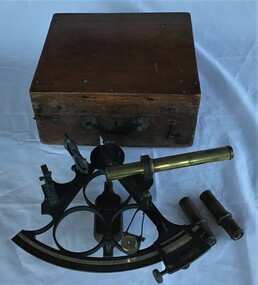
Instrument - Sextant in wooden box
... of the marine surveyor for 200 years used to measure angles between ...Sextant used by J P Larken, Government Marine SurveyorThe sextant has been the primary position fixing tool of the marine surveyor for 200 years used to measure angles between beacons or points for hydrographic surveys. A sextant in its own wooden box.On inside box lid; 'A. E. Parson surveying and scientific instrument maker, Queen Street, Melbournesextant, jp larken, marine surveyor -
 Warrnambool and District Historical Society Inc.
Functional object - Cloth Chart, A.E. Putnam Co. Iowa, U.S.A, c. 1896
This item was used to measure accurately the length of cloth on a bolt of material without unwinding it. It also measured lace, all types of textiles and spools of ribbon. It is surmised it would have been used in general stores or department stores in the late 19th and early 20th centuries. This item was discovered in the late 1980s behind an old safe at Swintons Stores in Timor Street in Warrnambool. The item appears to have been used extensively and would have been very useful during a stocktake. It may have been used in the Swinton Stores which were first established in Timor Street in 1865 with one section of the stores selling furnishings, furniture, clothing and clothing materials. The item was manufactured by A.E. Putnam of Iowa, U.S.A. There was a patent registered in 1896 and a later 'improved' model with a patent date of 1907. This item is of considerable interest because of its rarity and survival, its connection to Warrnambool General Stores in the past and its value as a research tool in local social and economic history. The possible connection to Swintons Stores is important as this business operated from 1865 to 2024 and was one of the longest-surviving family businesses in Australia. This is a rectangular-shaped wooden pole with one slightly flattened side and numbers marked on each side in patterns resembling brick walls. At the top of the pole are two wooden pieces attached to the pole by metal clips held by screws. The two wooden pieces are attached at a slight angle to the pole. The lower wooden piece is movable along the pole and has incised numbers. The wooden pieces are rectangular in shape with a large curved piece cut out to form the shape of a pennant. The maker's name is incised into the metal on the top attached wooden piece. Putnam's Cloth Chart Copyrighted 1896 Patent Pend'ggeneral stores in warrnambool, swintons stores in warrnambool, vintage measuring instrument for cloth -
 Bendigo Military Museum
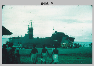
Photograph - Royal Australian Survey Corps Surveyors in the Field – Project Cutlass, New Guinea, 1956 – 1957
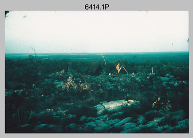
... theodolites to observe horizontal and vertical angles and chains... theodolites to observe horizontal and vertical angles and chains ...This is a set of 23 photographs of surveyors and support staff in the field undertaking tasks in New Guinea 1956 – 1957. The surveyors were employed in the establishment of mapping and geodetic control for Project Cutlass, the “Ship-Shore” survey of the New Ireland province. In this survey operation surveyors used theodolites to observe horizontal and vertical angles and chains to measure base line distances between survey stations. Bob Skitch shown in photo .7P was in the 2nd year of his career in the Australian Army. He achieved the rank of Lieutenant-Colonel, and his last appointment was the CO of the Army Survey Regiment from 1976 to 1980.This is a set of 23 photographs of surveyors and support staff in the field undertaking duties during Project Cutlass located in New Ireland, New Guinea 1956 – 1957. The photographs were printed on photographic paper and are part of the Army Survey Regiment’s Collection. The photographs were scanned at 300 dpi. .1) - Photo, colour, 1956. Surveyors travelling main road from Kavieng to Namatanai, New Ireland. .2) - Photo, colour, 1956. Unidentified surveyors assessing recovery of their vehicle after bridge collapsed on west side of New Ireland. .3) - Photo, colour, 1956. Unidentified surveyors assessing recovery of their vehicle after bridge collapsed over flooded creek on west side of New Ireland. .4) - Photo, colour, 1956. Survey personnel L to R: Bev Uwins, John Lambie, Bob Thompson, New Ireland. .5) - Photo, colour, 1956. Survey base camp, New Ireland. .6) - Photo, black & white, 1956-1957. Geoff Helsham with possible human remains, New Ireland. .7) - Photo, black & white, 1956-1957. Bob Skitch undertaking survey observations using Wild T2 theodolite, New Ireland. .8) - Photo, black & white, 1956-1957. Chas Beach undertaking survey observations using Wild T2 theodolite, New Ireland. .9) & .10) - Photo, black & white, 1956-1957. Kev Parker (cook) New Ireland. .11) - Photo, colour, 1957. Brian Berkery taking a break, Top Manor Island, Lihir Island Group off New Ireland. Latitude -2° 46”, Longitude 152° 40”. .12) - Photo, colour, 1957. Survey base camp L to R: Chas Beach, Bev Uwins, Feni Islands, New Ireland. Latitude -4° 05”, Longitude 153° 45”. .13) - Photo, colour, 1957. A Hous Kiap. (Kiaps, known formally as district officers and patrol officers, were travelling representatives of the British and Australian governments), New Ireland. .14) & .15) - Photo, colour, 1957. L to R: Joe Farrington, Tom Royle Bob undertaking survey observations using theodolites from an improvised timber tower, New Ireland. .16) & .17) - Photo, colour, 1957. US Army ship FS216 used for ship-to-shore triangulation docked at Rabaul, New Britain. .18) - Photo, colour, 1957. US Army ship FS216 used for ship-to-shore triangulation docked at Kavieng, New Ireland. Sight target on top of mast. .19) - Photo, colour, 1957. Survey personnel onboard US Army ship FS392, L to R: Peter Frodsham, Bob Thompson, Doc Reid, John Underwood, remainder unidentified, New Ireland. .20) - Photo, colour, 1957. Survey base line party heading ashore, New Ireland. .21) - Photo, colour, 1957. Survey personnel rowing US Army assault boat L to R: Kev Parker, Chas Beach, folded up survey beacons overhanging stern, New Ireland. .22) - Photo, colour, 1957. Les Bailey onboard US Army ship departing Rabaul, New Britain for Brisbane. .23) - Photo, colour, 1957. Ron Newman onboard US Army ship departing Rabaul, New Britain for Brisbane. Active volcano in background..1P to .23P annotated on back – ‘Operation Cutlass’, personnel names, the year and the location. royal australian survey corps, rasvy, army survey regiment, fortuna, a, army svy regt, asr, surveying -
 Bendigo Military Museum
Photograph - Royal Australian Survey Corps Surveyors in the Field – Northern Territory and Queensland, 1959 – 1960
... used theodolites to observe horizontal and vertical angles... used theodolites to observe horizontal and vertical angles ...This is a set of 10 photographs of surveyors and support staff in the field undertaking duties in the Northern Territory and North Queensland in 1959 – 1960. The surveyors were employed in the establishment of mapping and geodetic control. In this era surveyors used theodolites to observe horizontal and vertical angles and tellurometers to measure base line distances between survey stations. Laplace survey observations seen in Photo .1P was a series of precise observations carried out at geodetic survey stations to determine astronomic latitudes, longitudes and azimuths to achieve maximum precision in the survey network. Laplace observations were necessary in a geodetic network at every 6th survey station, however the National Mapping Council specified at this time the spacing would be ideally between 4-6 survey stations. The cairn shown in photo .4P was built by RASvy as a landmark over a trigonometric survey station. It was dismantled in 1960 to enable re-occupation and survey observations. It was not restored to the condition shown in the photo.This is a set of 10 photographs of surveyors and support staff in the field undertaking duties in the Northern Territory (NT) and Queensland (QLD) in 1959 – 1960. The photographs were printed on photographic paper and are part of the Army Survey Regiment’s Collection. The photographs were scanned at 300 dpi. .1) - Photo, colour, 1959. Tony Slattery occupying a Laplace survey station on a hill in the Mount Young area of the NT. .2) - Photo, colour, 1959. Surveyors’ camp in the Mount Young area of the NT, L to R: Spencer Snow and Tony Slattery. .3) - Photo, colour, 1959. Surveyors’ camp in the Peckman Hill area, near Katherine in the NT. .4) - Photo, colour, 1959. Cairn on Trig Hill, Borroloola, NT. Built by Spencer Snow, Tom Royle and Jack McCabe. .5) - Photo, colour, 1959. Survey party taking a break next to their Austin Champ vehicle, in transit between Katherine, NT and Wyndam WA. L to R: Tony Slattery, Dave Owens, John Van De Graff. .6) - Photo, colour, 1960. Surveyors’ camp between Mount Isa, QLD and Borroloola, NT. L to R: Pat Cox and John Van De Graff prepare their meal on an open fire. .7) - Photo, colour, 1960. Surveyor - Dennis Woods undertaking survey observations, using MRA1 tellurometer to measure base-line distances NW of Mount Isa, QLD. .8) - Photo, colour, 1960. Unidentified surveyors assessing recovery of their stalled Studebaker truck vehicle after attempting a water crossing in the NT. .9) - Photo, colour, 1960. Unidentified surveyor making batches of bread at a camp in the NT. Seen in the photo placing a lid with hot coals onto the camp oven. .10) - Photo, colour, 1960. Unidentified survey party occupying a survey station on a hill in the Mount near the Lawn Hill area, NW of Mount Isa, QLD. A MRA1 tellurometer to measure base-line distances appear on the right side of the photo. .9) - Photo, colour, 1960. Unidentified surveyors assessing recovery of their stalled Studebaker truck vehicle after attempting a water crossing in the NT. .10) - Photo, colour, 1960. Unidentified surveyor making batches of bread at a camp in the NT. Seen in the photo placing a lid with hot coals onto the camp oven. .1P to .10P annotated on back – personnel names, the year and the location. royal australian survey corps, rasvy, army survey regiment, asr, army svy regt, fortuna, surveying -
 Bendigo Military Museum
Photograph - Royal Australian Survey Corps Surveyors in the Field – North Queensland, 1958
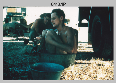
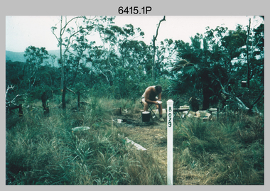
... theodolites to observe horizontal and vertical angles and chains... theodolites to observe horizontal and vertical angles and chains ...This is a set of seven photographs of surveyors and support staff in the field undertaking duties in North Queensland in 1958. The surveyors were employed in the establishment of mapping and geodetic control. In this era surveyors used theodolites to observe horizontal and vertical angles and chains to measure base line distances between survey stations. Bob Skitch shown in photos .4P to .6P was in the 2nd year of his career in the Australian Army. He achieved the rank of Lieutenant Colonel and his last appointment was the CO of the Army Survey Regiment from 1976 to 1980. The annotation on the back of photo .5P ‘Black foreground is where Bob Skitch boiled billy and started a grass fire’.This is a set of seven photographs of surveyors and support staff in the field undertaking duties in North Queensland in 1958. The photographs were printed on photographic paper and are part of the Army Survey Regiment’s Collection. The photographs were scanned at 300 dpi. .1) - Photo, colour, 1958. Surveyor in Nth QLD enjoying a bath. L to R: Don Cocker, Bob Thompson. .2) - Photo, colour, 1958. Don Cocker surveyor in Nth QLD, enjoying a bath. .3) - Photo, colour, 1958. Surveyors Nth QLD undertaking survey observations, using MRA1 tellurometer to measure base-line distances. L to R: Len Davies, Lou Sommer, John Van De Graff. MRA1 was covered to stop overheating. .4) - Photo, colour, 1958. Surveyors south of Richmond, QLD digging holes for the erection of a Bilby observation tower. L to R: John Van De Graff, Bob Skitch, Kev Moody, Mal Hayes, Don Gray .5) - Photo, colour, 1958. Surveyors south of Richmond, QLD erecting a Bilby observation tower. L to R: Tom Royle, Bob Skitch (on ground level), Mal Hayes. .6) - Photo, colour, 1958. Surveyors south of Richmond, QLD erecting a Bilby observation tower. L to R: Tom Royle, Bob Skitch, Mal Hayes, Jim McGill (on ground level). .7) - Photo, colour, 1958. Surveyors south of Richmond, QLD undertaking survey measurements from a Bilby observation tower..1P to .7P annotated on back – personnel names, the year and the location. Annotated on back of .5P ‘Black foreground is where Bob Skitch boiled billy and started a grass fire’.royal australian survey corps, rasvy, army survey regiment, asr, army svy regt, fortuna, surveying -
 Bendigo Military Museum
Photograph - Royal Australian Survey Corps Surveyors in the Field – Victoria, 1956 - 1958
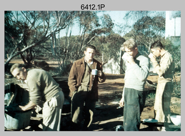
... horizontal and vertical angles and chains to measure base line... horizontal and vertical angles and chains to measure base line ...This is a set of two photographs of surveyors and support staff in the field undertaking tasks in Victoria 1956 – 1958. The surveyors were employed in the establishment of mapping and geodetic control. In this era surveyors used theodolites to observe horizontal and vertical angles and chains to measure base line distances between survey stations. This is a set of 23 photographs of surveyors and support staff in the field undertaking duties in Victoria 1956 – 1958. The photographs were printed on photographic paper and are part of the Army Survey Regiment’s Collection. The photographs were scanned at 300 dpi. .1) - Photo, colour, 1956. Surveyors enjoying a tea break. L to R: Tom Gilbert (cook), Barry Broad, Tony Slattery, John Van De Graff. Taken at Boonoonar, a locality south of Mildura. .2) - Photo, colour, 1958. Surveyors taking a break from driving. L to R: Leo Bub, Bob Thompson. Taken at Puckapunyal..1P to .2P annotated on back – personnel names, the year and the location. royal australian survey corps, rasvy, army survey regiment, asr, army svy regt, fortuna, surveying -
 Bendigo Military Museum
Photograph - Royal Australian Survey Corps Surveyors in the Field – North Queensland and Torres Strait, 1961
... used theodolites to observe horizontal and vertical angles... used theodolites to observe horizontal and vertical angles ...This is a set of five photographs of surveyors and support staff in the field undertaking duties in North Queensland and Torres Strait in 1961. The surveyors were employed in the establishment of mapping and geodetic control. In this era surveyors used theodolites to observe horizontal and vertical angles and tellurometers to measure base line distances between survey stations. In photo .2P Joe Farrington is seen taking survey observations using a Tavistock V500 Series Tavistock theodolite at a survey station between the Edward River and Aurukun in the Cape York Peninsula. The Gulf of Carpentaria appears in the background. From 1957 helicopter transport of survey parties revolutionised transport in remote areas. The civilian helicopter was hired from TAA. This is a set of five photographs of surveyors and support staff in the field undertaking duties in North Queensland and Torres Strait in 1961. The photographs were printed on photographic paper and are part of the Army Survey Regiment’s Collection. The photographs were scanned at 300 dpi. .1) - Photo, colour, 1961. Andy Millar occupying a survey station on a hill in the Cape York Peninsula, QLD. .2) - Photo, colour, 1961. Joe Farrington taking observations with a V500 Series Tavistock geodetic theodolite at a survey station in the Cape York Peninsula, QLD. .3) - Photo, colour, 1961. Daryl Parker taking a break from survey observations on a hill located on Duaun Island QLD, in the Torres Strait, a few miles south of the PNG coastline. Hill height was 975 ft. .4) - Photo, colour, 1961. Three Torres Strait divers L to R: unidentified, Darku and Ray Mau Daryl standing behind a Tavistock geodetic theodolite on a hill located on Duaun Island QLD, in the Torres Strait, a few miles south of the PNG coastline. .5) - Photo, colour, 1961. Andy Millar holding meat from a small turtle on Duaun Island QLD, in the Torres Strait, a few miles south of the PNG coastline. An unidentified Duaun Island local appears in the background..1P to .5P annotated on back – personnel names, the year and the location. royal australian survey corps, rasvy, army survey regiment, asr, army svy regt, fortuna, surveying -
 Bendigo Military Museum
Photograph - Royal Australian Survey Corps Surveyors in the Field – PNG, 1962
... horizontal and vertical angles and tellurometers to measure base line... horizontal and vertical angles and tellurometers to measure base line ...This is a set of four photographs of surveyors and support staff in the field undertaking duties in Dogera, Milne Bay Province and Kerema, Gulf Province of PNG in 1962. The surveyors were employed in the establishment of mapping and geodetic control. In this era surveyors used theodolites to observe horizontal and vertical angles and tellurometers to measure base line distances between survey stations. From 1957 helicopter transport of survey parties revolutionised transport in remote areas.This is a set of four photographs of surveyors and support staff in the field undertaking duties in PNG in 1962. The photographs were printed on photographic paper and are part of the Army Survey Regiment’s Collection. The photographs were scanned at 300 dpi. .1) - Photo, colour, 1962. Unloading survey operation stores from a Landing Ship Medium (LSM) at Dogera, Milne Bay Province, PNG. .2) & .3) - Photo, colour, 1962. Hired civilian helicopter Bell 47G-2 helicopters operating at at Dogera, Milne Bay Province, PNG. .4) - Photo, colour, 1962. Survey party at survey station located near Kerema, Gulf Province southern PNG. L to R: Dave Owens, Keith Broadbent, with local villagers in background..1P to .4P annotated on back – personnel names, the year and the location. royal australian survey corps, rasvy, army survey regiment, asr, army svy regt, fortuna, surveying -
 Forests Commission Retired Personnel Association (FCRPA)
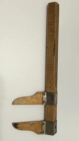
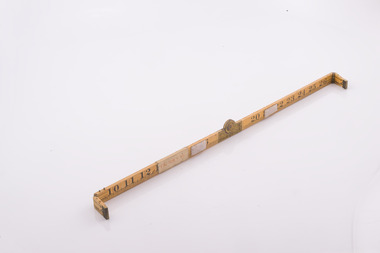
Basal Area Angle Gauge
Foresters usually measure the diameter of trees at Breast Height – traditionally 4 foot, 6 inches – now 1.3 m – which is termed Diameter Breast Height Over Bark (DBHOB). Basal Area is the cross section of the tree trunk at breast height, and the sum for the stand or group of trees is expressed square feet per acre (after 1973 it was expressed in square metres per hectare). Lots of skinny trees, or a few fat ones, can have the same Basal Area, but when combined with the number of stems, Basal Area is a good indicator of stand density. Two common methods are used to measure of Basal Area – fixed area plots and angle count sampling. 1. Fixed area plots require setting out a small area, commonly 50 m x 20 m, and measuring all the trees at breast height, and doing some quick sums. 2. Angle count sampling involves a simple sweep of the forest from a fixed sampling point using a relascope, dendrometer sight, angle gauge, or glass wedge prism. This wooden builders ruler has been shaped at one end to create a shallow angle (usually less than 3 degrees). Standing in one spot, a sweep is made with the wedge held to the eye, and trees are counted as either “in” or “out”. The number of trees is multiplied by conversion factor of the wedge (10 in this case) to estimate basal area. It’s very quick and effective.Basal Area Angle Gauge The two ends fold up and one end (on the right) has been reduced in width to create a shallow angle for the viewer Home made by cutting down a wooden builder's ruler Many forestry students made their own Basal Area Angle Gauges and its thought this may be oneforest measurement, forests commission victoria (fcv)