Showing 424 items matching "mining town"
-
 Clunes Museum
Newspaper - NEWSPAPER CUTTING, ARGUS AGE, 1 CLUNES BIRTHDAY .2 FAMOUS MINING TOWNS, 4 - 7 - 1931 27 - 8 - 32
... NEWSPAPER HEADLINES. CLUNES BIRTHDAY. FAMOUS MINING TOWNS...NEWSPAPER HEADLINES. CLUNES BIRTHDAY. FAMOUS MINING TOWNS ...NEWSPAPER HEADLINES. CLUNES BIRTHDAY. FAMOUS MINING TOWNS .1. 80TH ANNIVERSARY JULY 4, 1931 .2. THE QUARTZ REEFS OF CLUNES. SOME INTERESTING DOCUMENTS..2 NEWSPAPER CUTTINGS. .1. CLUNES MINING 80TH ANNIVERSARY JULY 4, 1931 .2. THE QUARTZ REEFS OF CLUNES. SOME INTERESTING DOCUMENTS.local history, document, newspaper cutting, mining -
 Bendigo Historical Society Inc.
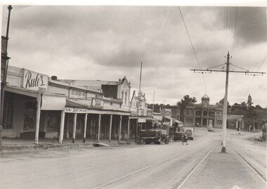
Photograph - CARWARDINE COLLECTION: EAGLEHAWK, HIGH STREET, 1953
... ., Eaglehawk prosperous mining town 5 miles N.E of Bendigo No1.... prosperous mining town 5 miles N.E of Bendigo No1. Photograph ...Photograph. Carwardine collection Herald Sun black and white photograph of High Street, Eaglehawk, showing shops and Town Hall, written on back in WT Sept 2 1953 page 18 High St., Eaglehawk prosperous mining town 5 miles N.E of Bendigo No1.Herald Sunphotograph, streetscape, eaglehawk, bendigo-eaglehawk-history -
 Ballarat and Queen's Anglican Grammar School
Coloured Photograph of Church, Chapel Ballarat Church of England Grammar School, 2000
... of England Diocese and brought from the old mining town of Jerusalem... of England Diocese and brought from the old mining town of Jerusalem ...This photograph of the Wallinduc St Agnes Church was taken in 2000. The church was purchased by the Ballarat Church of England Diocese and brought from the old mining town of Jerusalem in 1912 to be used as a School chapel.Coloured photograph of a white weatherboard church with a red iron roofballarat, ballarat-grammar, cegs, wallinduc, st-agnes-church, church-of-england, ballarat-diocese, chapel -
 Bendigo Historical Society Inc.
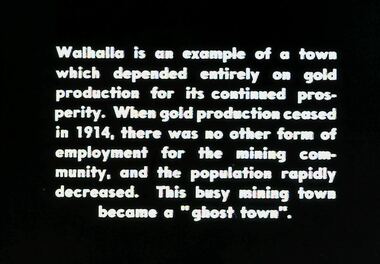
Slide - DIGGERS & MINING. DIGGERS AND MINERS, c1850s
... Diggers & Mining. Diggers and miners. Walhalla - Gold Town... rapidly decreased. This busy mining town became a ''ghost town ...Diggers & Mining. Diggers and miners. Walhalla - Gold Town. Walhalla is an example of a town which depended entirely on gold production for its continued prosperity. When gold production ceased in1914. there was no other form of employment for the mining community, and the population rapidly decreased. This busy mining town became a ''ghost town''. Markings: 4 995 WAL. Used as a teaching aid.hanimounteducation, tertiary, goldfields -
 Federation University Historical Collection
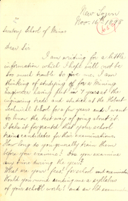
Letter - Correspondence, Edgar McConnon, Letter from Edgar McConnon to Ballarat School of Mines, 1898, 16/11/1898
... McConnon New Town Mining Engineering Hobart Ballarat Tasmania New ...The Ballaray School of Mines is a predecessor institution of Federation Univerity Australia, Four cream blue feint lined pages folded with handwriting in black ink on two pagesFront: 659 handwritten in circle on top right hand page Inside on right hand page: "Replied to 6 Dec" in handwriting in middle of right hand pageballarat school of mines, mcconnon, edgar mcconnon, new town, mining engineering, hobart, ballarat, tasmania, new town -
 Bendigo Historical Society Inc.
Slide - DIGGERS & MINING: BENDIGO
... Diggers & Mining: Bendigo. Bendigo Town Hall. Markings: 18... EDUCATION Tertiary bendigo Kodachrome Diggers & Mining: Bendigo ...Diggers & Mining: Bendigo. Bendigo Town Hall. Markings: 18, DEC74M10. Used as a teaching aid.Kodachromeeducation, tertiary, bendigo -
 Ballarat Heritage Services
Photograph - Photograph - Colour, Clare Gervasoni, Tarilta, 2017, 16/07/2017
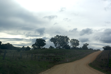
... Tarilta is a rural locality and former gold-mining town 12...-mining town 12 km south of Castlemaine, 4 km north-west ...Tarilta is a rural locality and former gold-mining town 12 km south of Castlemaine, 4 km north-west of Guildford and 3 km north-east of Vaughan. The last gold mining activity took place around the 1880s. It was originally Kangaroo Flat, being located where the Kangaroo Creek enters the Loddon River. It was surveyed and named in 1864. Gold was discovered at Tarilta in 1853. The Tarilta School was opened in 1860 in a Wesleyan chapel, and closed i n1925. In 1864 a township was surveyed and named Tarilta, the word being derived from an Aboriginal expression thought to mean kangaroo. In 1865 Bailliere’s Victorian gazetteer described Tarilta as being an alluvial and quartz gold-mining town with three quartz-crushing mills, three horse-puddling machines and two hotels. The elevated nature of the land around Tarilta made it accessible only by horse and dray, or on horseback. Colour photograph of Tarilta in Central Victoria. tarilta, central victoria, landcape -
 Robin Boyd Foundation
Document - Script, Robin Boyd, The Flying Dogtor. Episode 10 Ghost Town, 1963
... for the Dogtor's help in the main street of Ghostville, the old mining town... for the Dogtor's help in the main street of Ghostville, the old mining town ...After the fire was distinguished and the flood subsided, on his way flying home, the Dogtor heard voices repeatedly on his radio "Calling Flying Dogtor". A sick voice asked for the Dogtor's help in the main street of Ghostville, the old mining town across Dry Gulch Gully, now a ghost town. He got to the abandoned address, 13 ("unlucky number") Spook Street. The Dogtor is about to open the door...The Flying Dogtor" series was broadcast on Australian Television Network (later becoming the Seven Network) between February and April 1964 (see item D254 for schedule).Typewritten, carbon copy, foolscap, 2 pagesPage 1: Left hand side has been amended and is attached with tape. Written corrections on right hand side.the flying dogtor, robin boyd, crawford productions, manuscript -
 Victorian Interpretive Projects Inc.
Photograph - colour, Clare Gervasoni, Stawell Town Hall, 13/08/2012
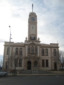
... Stawell was known as a gold mining town. The Stawell Town..., 3350 goldfields Stawell was known as a gold mining town ...Stawell was known as a gold mining town. The Stawell Town Hall clock and tower were erected by Mrs Norman Kelly in memory of her late father Cr George Barnes, a councillor of the Borough of Stawell over a period of 47 years, and also her mother, the late Emma Barnes. 10 May 1939. The animated mining scene on the Stawell Town Hall was incorporated into the tower from a bequest by Emma Kelly. It was officially opened by Sir Henry Bolte on 06 October 1969.Colour photograph of the Stawell Town Hall, and details such as the mining logo and plaques.stawell, stawell town hall, mining, george barnes, emma barnes, emma kelly, henry bolte -
The Beechworth Burke Museum
Audio - Oral History, Jennifer Williams, Mr Ken Blake and Mrs Doreen Blake, 30th March 2000
... . They saw the town develop from a small mining town in rural.... They saw the town develop from a small mining town in rural ...Ken and Doreen came to Beechworth on boxing day in 1959, when they were offered a business at a good price. This business was the Ovens and Murray advertiser, one of the oldest running newspapers in Australia. When they arrived Ken already had a background as a professional linotype operator, however both him and Doreen had no experience running a town newspaper. Ken and Doreen owned the paper till the 1980s, when they formed the Blake press. Throughout the years the Blakes kept up to date with Beechworth news, politics and events happening throughout the community, Ken was even permitted to sit in on the town committee meetings. They saw the town develop from a small mining town in rural Victoria, to a bustling, tourist hotspot.This oral history is significant because it shows how the town of Beechworth developed from a small outpost mining town to a popular tourist destination. It also showcases a different perspective of the towns development, that of the new owners (at the time) of the Ovens and Murrary Advertiser. The advertiser is an integral part of Beechworth's history and has been running since it was proclaimed a town (proclaimed a town in 1856, the advertiser first ran its paper in 1855). Without the advertiser the history of Beechworth would be buried, but with newspapers dating back all the way to 1855, Beechworth is provided with a rich and vibrant retelling of the history of their town and what life was like from 1855 to present day. Ken and Doreen's oral history provides an insight into what it was like revitalising a worn out part of history, of restoring it back to its former glory. They demonstrate the highs and lows of living and running a business in Beechworth through economic lows and the impact of both social and physical isolation.This is a digital copy of a recording that was originally captured on a cassette tape. The cassette tape is black with a horizontal white strip and is currently stored in a clear flat plastic rectangular container. It holds up 40 minutes of recordings on each side.newspaper, blakes, ken and doreen, ovens and murray advertiser, beechworth, development, o&m, 1960s, 1980s, 1970s -
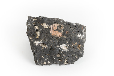
 The Beechworth Burke Museum
Geological specimen - Opal Bearing Stone, Unknown
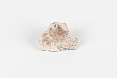
... year. It is a historic mining town, and is known for its... year. It is a historic mining town, and is known for its ...There are 17 opal fields in Australia. This opal bearing stone was found in Lightning Ridge, NSW over what is known as the Great Australian Basin. This basin was formed and covers an area of 1.7 million square kilometers in eastern Australia in the Cretaceous period. This basin used to contain an inland sea, which provided an environment where silcrete eventually formed when water levels changed. This eventually seeped into other structures, and eventually hardened and formed opal. Lightning Ridge has a population of around 2000 people, with about 80 000 visitors every year. It is a historic mining town, and is known for its deposits of a rare black opal. Mining started in the area in the late 1800s, early 1900s when the black opal was discovered. This opal-bearing stone is of social and historical significance. It is from Lightning Ridge, which is well-known for being a large producer of opal stones, most famously black opal. The history of the period dates back to 140 million years, with the discovery of black opal in the early 1900s causing interest in the area. This specimen is part of a larger collection of geological and mineral specimens collected from around Australia (and some parts of the world) and donated to the Burke Museum between 1868-1880. A large percentage of these specimens were collected in Victoria as part of the Geological Survey of Victoria that begun in 1852 (in response to the Gold Rush) to study and map the geology of Victoria. Collecting geological specimens was an important part of mapping and understanding the scientific makeup of the earth. Many of these specimens were sent to research and collecting organisations across Australia, including the Burke Museum, to educate and encourage further study.***A palm-sized solid mineral specimen in shades of beige and light orange*** silica based? burke museum, beechworth, geological, geological specimen, opal, opal fields, australia, lightning ridge, new south wales, great australian basin, cretaceous, silcrete, black opal, mining -
Upper Yarra Museum
Food Safe, Untitled
... after the place where it was invented — the small mining town... it was invented — the small mining town of Coolgardie, Western Australia ...http://museumvictoria.com.au/discoverycentre/infosheets/the-coolgardie-safe/ http://en.wikipedia.org/wiki/Coolgardie_safe The Coolgardie Safe is a low-tech refrigeration unit which uses the heat transfer which occurs during evaporation of water. It was named after the place where it was invented — the small mining town of Coolgardie, Western Australia, near Kalgoorlie-Boulder. http://www.biggles.com.au/ The Coolgardie Safe was simply a wire framed box with wheat sack strips hanging down the sides, which were kept wet by the process of osmosis from a dish or small tank of water. The food inside the Safe was kept cool due to the principle that evaporation takes away heat; the wet hessian strips experience evaporation from the wind and the sun and thus you have a refrigerator. http://www.whitehat.com.au/australia/Inventions/InventionsA.html Coolgardie Safe made from galvanised iron with hessian drapped over 4 sides, rectangular on 4 legs. 2 trays inside, 3rd tray inserted in top as cover, metal meshing on callapsable sides and door. Stands in tray. The tray assists with pest control as it was filled with water.kitchen galvanised iron coolgardie safe hessian food preservation pest control water -
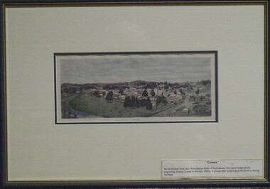 Clunes Museum
Print - ANTIQUARIAN PRINT, 1890
... 1880's. It shows little evidence of the town's mining heritage... 1880's. It shows little evidence of the town's mining heritage ...An illustration from the Picturesque Atlas of Australasia, hand-tinted photo-engraving by W.C. Fitler shows Clunes in late 1880's. It shows little evidence of the town's mining heritageTINTED RELIEF WOOD ENGRAVING PRINT OF THE TOWNSHIP OF CLUNES. HAND COLOURED, MOUNTED AND FRAMED WITH CREAM COLOURED MATT, DARK GREEN FRAME AND GOLD INSIDE TRIM.GENUINE ANTIQUARIAN PRINT LABEL ON BACK FROM LECKIE GALLERYwood engraving, relief, 1890, w.c.fitler -
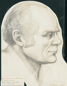 Uniting Church Archives - Synod of Victoria
Photograph, Reverend Greme Bence Moderator Northern Synod of the Uniting Church
... on 24 December 1930 in the coal mining town of Tonyrefail, New... into a Methodist family on 24 December 1930 in the coal mining town ...Rev. Graeme Dudley Bence was born into a Methodist family on 24 December 1930 in the coal mining town of Tonyrefail, New South Wales. His family moved to Bornemouth England in 1931. He married Doreen in Bristol on 21 June 1952. Rev. Bence was ordained at East Cliff Congregational Church Bournemouth on 26 May 1953. He was commissioned to the sevice of the London Missionary Society in Papua and subsequently served in Australia starting at Hughesdale Congregational Church from 1958 to 1965 and Wyclif Congregational Chruch Surrey Hills from 1965 to 1972. In 1972 he accepted a call to the Nightcliff Church in Darwin and became Assistant Director of Mission and Service in the Uniting Church of North Australia. The Northern Synod elected Graeme Moderator from 1981 to 1983. He returned to Victoria in 1986 and retired to Rosebud in 1991. He died on 31 July 1994.Head and shoulders drawing in profile of Rev. Graeme Bence.bence, graeme -
 Buninyong & District Historical Society
Photograph - Original B/W Photograph, De Soza park, Warrenheip St., Buninyong, with poppet head, rotunda and Chilean Wheel sculpture
... are representative of the gold mining origins of the town.... of the gold mining origins of the town. The park, located centrally ...De Soza park was developed as a public amenity from the early 1980s. The poppet head and Chilean wheel sculpture are representative of the gold mining origins of the town.The park, located centrally in Buninyong is of social and historic significance.Original B/W photograph of streetscape of De Soza park frontage to Warrenheip St., Buninyong, with poppet head, rotunda and Chilean Wheel sculpture, former post office in background. Large eucalypt tree present behind rotunda, large cypress tree to north of park.buninyong, de soza, park, rotunda, poppet head, sculpture, chilean wheel, post office, warrenheip st, streetscape -
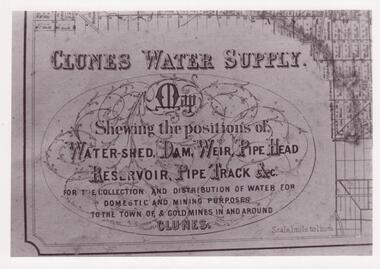 Clunes Museum
Document - MAP
... FOR DOMESTIC AND MINING PURPOSES TO THE TOWN OF & GOLDMINES... FOR DOMESTIC AND MINING PURPOSES TO THE TOWN OF & GOLDMINES ...CLUNES WATER SHED SUPPLY MAP SHEWING THE POSITION OF WATERSHED ECT. FOR THE COLLECTION AND DISTRIBUTION OF WATER FOR DOMESTIC AND MINING PURPOSES TO THE TOWN OF & GOLDMINES IN AND AROUND CLUNES.PHOTOCOPY SECTION OF PHOTOGRAPH AND PLAQUE AND MAP OF CLUNES WATER SUPPLY. SHOWING THE POSITION OF WATERSHED, DAM, WEIR PIPEHEAD RESERVOIR PIPE TRACK.SEE PHOTOGRAPH ON BACK OF HISTORY OF OBJECT.local history, photographs, water supply -
 The Beechworth Burke Museum
Geological specimen - Basalt, Unknown
... Talbot in Victoria, which was a small gold mining town... Talbot in Victoria, which was a small gold mining town ...Basalt is a common igneous rock that composes most of the Earth's surface and can be found on the Moon and other rocky planets of the Solar System. It is generally composed minerals such as calcic plagioclase, clinopyroxene and iron ore which form grains that are indistinguishable to the naked eye. It can be dark grey or black in colouring and sometimes may contain holes left by gas bubbles. Most of the Earth's basalt was produced in environments such as oceanic divergent boundaries, oceanic hotspots, and mantle plumes and hotspots beneath continents. Basalt is commonly used in construction where it is crushed and used for multiple purposes such as concrete aggregate, road base, or railroad ballast. Thin slabs of basalt can also be cut and used for floor tiles, stone monuments, and building veneer. This particular specimen was excavated from Talbot in Victoria, which was a small gold mining town established in 1852. As basalt is a common rock, it is not specific to Talbot. However, this specimen can be assumed to be of the Cainozoic age due to previous geomorphic surveys of the area. This particular type of Basalt was used mainly for roads due to the durability of the rock.Basalt holds significance due to the continued use of the rock from historic until present times. The rock has been utilised for many types of construction and is still used for the same purposes today. Basalt also has significance to the Earth and other rocky planets of the Solar System as it makes up most of the planet's surface. This specimen is part of a larger collection of geological and mineral specimens collected from around Australia (and some parts of the world) and donated to the Burke Museum between 1868-1880. A large percentage of these specimens were collected in Victoria as part of the Geological Survey of Victoria that begun in 1852 (in response to the Gold Rush) to study and map the geology of Victoria. Collecting geological specimens was an important part of mapping and understanding the scientific makeup of the earth. Many of these specimens were sent to research and collecting organisations across Australia, including the Burke Museum, to educate and encourage further study.A smaller than hand sized rock specimen which is dark grey in colour with small holes and white deposits across its surface.Geological survey / [illegible] /burke museum, beechworth, geological specimen, geology, basalt, basalt specemin, indigo shire, talbot, cainozoic, igneous rock -
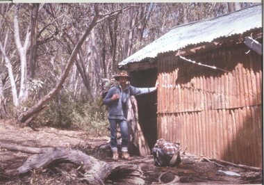 Kiewa Valley Historical Society
Photograph - Coloured Photographs x 5 - Bogong High Plains, January 1969 and c1970
... Valley, a small mining town, to get help. Mick and Cleve were... Valley, a small mining town, to get help. Mick and Cleve were ...Bivouac Hut was built in 1935 on the Northern end of Mt. Bogong, on the Staircase Spur, about halfway to the summit. It was funded by Cleve Cole and he arranged for Walter Maddison to build it. Cleve Cole dedicated his life to the mountains and wanted to make them safer to visit - more huts and improved maps, pole lines and tracks. He perished in the winter of 1936 after attempting to make the first winter crossing from Mt. Hotham to Mt. Bogong on skis. The two others with him, Howard Michell and Mick Hull survived. The weather conditions were extreme at the time and having made the summit of Mt. Bogong they then became disorientated in the blizzard and came down the southern end of Bogong instead of the northern end . Howard Michell made it out to Glen Valley, a small mining town, to get help. Mick and Cleve were carried out on rough bush stretchers and Cleve died a few hours later. The Summit Hut was funded by Howard Michell and built in the 1940's. It was deliberately burnt down in the early 1980's. Bivouac hut was rebuilt in the 1980's.These photographs are of historical significance. Both huts were funded by experienced bushwalkers to provide shelter from the weather and so make walking and skiing in the area safer. They are both now gone with Bivouac being replaced with a more modern structure but there is nothing left of the Summit Hut. 5 coloured photographs, A4 in size, 4 near the summit of Mt. Bogong (Three of the Summit Hut) and one of Bivouac Hut on the Staircase Spur leading up to the summit.1. Hand written in ink on back of Photo - "Mt. Bogong Sep. 1976' - all underlined. Below this "Staircase Spur Hut The bloke in the hat me (David Jones)". 2. Handwritten in ink on back of photo - "Mt. Bogong winter 1970" (underlined). Underneathe "Same old Hut". 3. Handwritten in ink "Mt. Bogong Jan. 1969" (Underlined) Underneath "Tawonga Saddle looking towards the Summit". 4.Handwritten in ink back of photo "Mt. Bogong Jan. 1969" (underlined) Old hut near Summit, since removed, at the top of Staircase Spur. View looking out over Kiewa Valley." 5.Hand written on back of photo "Mt. Bogong Jan. 1969" (Underlined). Underneath - " Same old Hut (Staircase Spur) early morning".mt. bogong, summit hut, bivouac hut -
Unions Ballarat
The history of Ballarat, from the first pastoral settlement to the present time, William Bramwell Withers, 1980
... development 7. Development of mining 8. The town of Ballarat .... Development of mining 8. The town of Ballarat Historical - Ballarat ...History of Ballarat. Table of contents: 1. Ballarat before the gold discovery 2. The gold discovery 3. From the gold discovery 4. Digger hunting 5. The Eureka Stockade 6. Political development 7. Development of mining 8. The town of Ballarat Historical - Ballarat.Paper; book. Front cover: author's name and title.btlc, ballarat trades hall, ballarat trades and labour council, eureka stockade, mining - gold, gold, politics, miners -
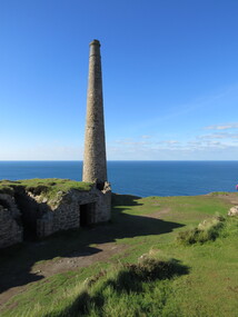
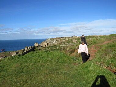
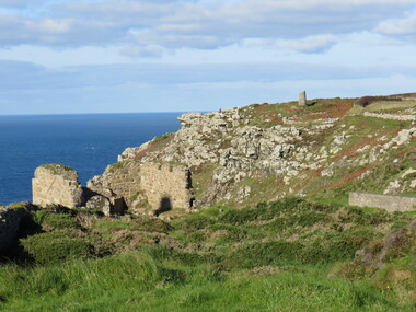
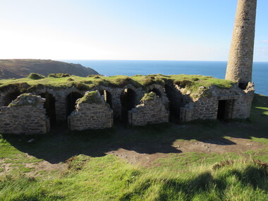
 Ballarat Heritage Services
Photograph - Colour, Dorothy Wickham, St Just, Cronwall, World Heritage Site
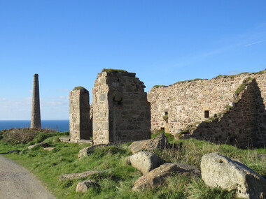
... . The historic mining town of St Just is home to characteristic rows... to the public in the UK. The historic mining town of St Just is home ...A stone’s throw from Land’s End, this is the most westerly Area of the Site. St Just is characterised by big skies, jagged rocks, stark moorland, and iconic clifftop engine houses perched above the Atlantic in some incredible locations. No wonder this dramatic setting has inspired generations of artists, writers and photographers. World-famous for their mineralogy, the mining sites here are extremely well preserved – as is the sense of community amongst the people whose lives they once dominated. This Area’s unique geography and mineralogy meant that undersea mining was more concentrated here than anywhere else in the world in the 18th and 19th centuries. The oldest surviving Cornish beam engine (constructed in 1840) remains in its original engine house at Levant, restored and still working under steam. Geevor, one of the last mines to close in Cornwall (1990), was saved from demolition and is now the largest metalliferous mine site open to the public in the UK. The historic mining town of St Just is home to characteristic rows of granite mine workers’ cottages, public squares, shops, cafés, art galleries and, just off Bank Square, a medieval grassed amphitheatre – the Plen an Gwary or ‘playing place’.st just, world heritage, ellis, penrose, cornwall, mining, mines -
 Ballarat Heritage Services
Photograph - Colour, Dorothy Wickham, St Just, Cornwall, World Heritage Site
... . The historic mining town of St Just is home to characteristic rows... to the public in the UK. The historic mining town of St Just is home ...A stone’s throw from Land’s End, this is the most westerly Area of the Site. St Just is characterised by big skies, jagged rocks, stark moorland, and iconic clifftop engine houses perched above the Atlantic in some incredible locations. No wonder this dramatic setting has inspired generations of artists, writers and photographers. World-famous for their mineralogy, the mining sites here are extremely well preserved – as is the sense of community amongst the people whose lives they once dominated. This Area’s unique geography and mineralogy meant that undersea mining was more concentrated here than anywhere else in the world in the 18th and 19th centuries. The oldest surviving Cornish beam engine (constructed in 1840) remains in its original engine house at Levant, restored and still working under steam. Geevor, one of the last mines to close in Cornwall (1990), was saved from demolition and is now the largest metalliferous mine site open to the public in the UK. The historic mining town of St Just is home to characteristic rows of granite mine workers’ cottages, public squares, shops, cafés, art galleries and, just off Bank Square, a medieval grassed amphitheatre – the Plen an Gwary or ‘playing place’.st just, world heritage,, ellis,, penrose, cornwall, mining, mines -
 Ballarat Heritage Services
Photograph - Colour, Dorothy Wickham, St Just, Cornwall, World Heritage Site
... . The historic mining town of St Just is home to characteristic rows... to the public in the UK. The historic mining town of St Just is home ...A stone’s throw from Land’s End, this is the most westerly Area of the Site. St Just is characterised by big skies, jagged rocks, stark moorland, and iconic clifftop engine houses perched above the Atlantic in some incredible locations. No wonder this dramatic setting has inspired generations of artists, writers and photographers. World-famous for their mineralogy, the mining sites here are extremely well preserved – as is the sense of community amongst the people whose lives they once dominated. This Area’s unique geography and mineralogy meant that undersea mining was more concentrated here than anywhere else in the world in the 18th and 19th centuries. The oldest surviving Cornish beam engine (constructed in 1840) remains in its original engine house at Levant, restored and still working under steam. Geevor, one of the last mines to close in Cornwall (1990), was saved from demolition and is now the largest metalliferous mine site open to the public in the UK. The historic mining town of St Just is home to characteristic rows of granite mine workers’ cottages, public squares, shops, cafés, art galleries and, just off Bank Square, a medieval grassed amphitheatre – the Plen an Gwary or ‘playing place’.st just, world heritage, ellis, penrose, cornwall, mining, mines -
 Ballarat Heritage Services
Photograph - Colour, Dorothy Wickham, St Just, Cronwall, World Heritage Site
... . The historic mining town of St Just is home to characteristic rows... to the public in the UK. The historic mining town of St Just is home ...A stone’s throw from Land’s End, this is the most westerly Area of the Site. St Just is characterised by big skies, jagged rocks, stark moorland, and iconic clifftop engine houses perched above the Atlantic in some incredible locations. No wonder this dramatic setting has inspired generations of artists, writers and photographers. World-famous for their mineralogy, the mining sites here are extremely well preserved – as is the sense of community amongst the people whose lives they once dominated. This Area’s unique geography and mineralogy meant that undersea mining was more concentrated here than anywhere else in the world in the 18th and 19th centuries. The oldest surviving Cornish beam engine (constructed in 1840) remains in its original engine house at Levant, restored and still working under steam. Geevor, one of the last mines to close in Cornwall (1990), was saved from demolition and is now the largest metalliferous mine site open to the public in the UK. The historic mining town of St Just is home to characteristic rows of granite mine workers’ cottages, public squares, shops, cafés, art galleries and, just off Bank Square, a medieval grassed amphitheatre – the Plen an Gwary or ‘playing place’.st just, world heritage, ellis, penrose, cornwall, mining, mines -
 Ballarat Heritage Services
Photograph - Colour, Dorothy Wickham, St Just, Cornwall, World Heritage Site
... . The historic mining town of St Just is home to characteristic rows... to the public in the UK. The historic mining town of St Just is home ...A stone’s throw from Land’s End, this is the most westerly Area of the Site. St Just is characterised by big skies, jagged rocks, stark moorland, and iconic clifftop engine houses perched above the Atlantic in some incredible locations. No wonder this dramatic setting has inspired generations of artists, writers and photographers. World-famous for their mineralogy, the mining sites here are extremely well preserved – as is the sense of community amongst the people whose lives they once dominated. This Area’s unique geography and mineralogy meant that undersea mining was more concentrated here than anywhere else in the world in the 18th and 19th centuries. The oldest surviving Cornish beam engine (constructed in 1840) remains in its original engine house at Levant, restored and still working under steam. Geevor, one of the last mines to close in Cornwall (1990), was saved from demolition and is now the largest metalliferous mine site open to the public in the UK. The historic mining town of St Just is home to characteristic rows of granite mine workers’ cottages, public squares, shops, cafés, art galleries and, just off Bank Square, a medieval grassed amphitheatre – the Plen an Gwary or ‘playing place’.st just, world heritage, ellis, penrose, cornwall, mining, mines -
 Ballarat Heritage Services
Photograph - Colour, Dorothy Wickham, St Just, Cornwall, World Heritage Site
... . The historic mining town of St Just is home to characteristic rows... to the public in the UK. The historic mining town of St Just is home ...A stone’s throw from Land’s End, this is the most westerly Area of the Site. St Just is characterised by big skies, jagged rocks, stark moorland, and iconic clifftop engine houses perched above the Atlantic in some incredible locations. No wonder this dramatic setting has inspired generations of artists, writers and photographers. World-famous for their mineralogy, the mining sites here are extremely well preserved – as is the sense of community amongst the people whose lives they once dominated. This Area’s unique geography and mineralogy meant that undersea mining was more concentrated here than anywhere else in the world in the 18th and 19th centuries. The oldest surviving Cornish beam engine (constructed in 1840) remains in its original engine house at Levant, restored and still working under steam. Geevor, one of the last mines to close in Cornwall (1990), was saved from demolition and is now the largest metalliferous mine site open to the public in the UK. The historic mining town of St Just is home to characteristic rows of granite mine workers’ cottages, public squares, shops, cafés, art galleries and, just off Bank Square, a medieval grassed amphitheatre – the Plen an Gwary or ‘playing place’.st just, world heritage, ellis, penrose, cornwall, mining, mines -
 The Beechworth Burke Museum
Photograph
... . The town would eventually become a huge gold mining town. Mitta.... The town would eventually become a huge gold mining town. Mitta ...Taken on 25 October 1930, various houses with the Hume Dam under construction are depicted in the background. The construction of the Hume Dam took place from 1919 to 1936. At the time of construction, it was the second largest dam in the world. It was also one of the earliest civil projects developed after the Federation. Some of the Dam workers consisted of World War I veterans. Dam workers often settled their families in Mitta Junction Village and Wodonga. Archaeological surveys were completed by Austral Archaeology, which was done when the Department of Land & Water Conservation was doing work to improve Hume Dam. The archaeological report that came out of the survey recommended three sites of interest where archaeological excavation should be done: Camp Ganger’s Quarters, Stableman’s Quarters, and the Industrial Dump. The excavation uncovered artefacts. Mitta Mitta: Mitta Mitta is situated between Mount Welcome and Mount Misery. It is named after the river that explorers Hume and Hovell discovered in 1824. The town would eventually become a huge gold mining town. Mitta Mitta is called Midamodunga by the local Indigenous peoples Wodonga: Wodonga is situated on the Murray River and is part of North East Victoria. Hume and Hovell: Hamilton Hume (1979-1873) and William Hilton Hovell (1786-1875). W. H. Hovell was born in Norfolk England and Hume was born in Parramatta, New South Wales Hovell and Hume undertook an exploration journey in 1824 and thought they discovered a river, which turned out to be the Murray River. They returned home in 1825, but returned to the area in 1826 and discovered coal in the area. This photo is historically significant as it shows the Hume Dam under construction in 1930. The Dam was named after Hamilton Hume, who is an important historical figure for this area as he helped discover the area where resources were found.Sepia rectangular photograph printed unmountedReverse: 84-19-5 / 1997.3185/ Values & spillway. / When completed the wall / will be as high as the / scaffolding. [featuring trademark: kodak print]construction, houses, veterans, mitta junction village, hume dam, world war i, federation, wodonga, archaeological survey, excavation, austral archaeology, department of land & water conservation, camp ganger's quarter's, stableman's quarters, industrial dump, artefacts, mitta mitta, mount welcome, mount misery, murray river, hamilton hume, william hilton hovell, hume and hovell expedition -
 The Beechworth Burke Museum
Photograph, c1930
... . The town would eventually become a huge gold mining town. Mitta.... The town would eventually become a huge gold mining town. Mitta ...Taken on 25 October 1930, various houses with the Hume Dam under construction are depicted in the background. The construction of the Hume Dam took place from 1919 to 1936. At the time of construction, it was the second largest dam in the world. It was also one of the earliest civil projects developed after the Federation. Some of the Dam workers consisted of World War I veterans. Dam workers often settled their families in Mitta Junction Village and Wodonga. Archaeological surveys were completed by Austral Archaeology, which was done when the Department of Land & Water Conservation was doing work to improve Hume Dam. The archaeological report that came out of the survey recommended three sites of interest where archaeological excavation should be done: Camp Ganger’s Quarters, Stableman’s Quarters, and the Industrial Dump. The excavation uncovered artefacts. Mitta Mitta: Mitta Mitta is situated between Mount Welcome and Mount Misery. It is named after the river that explorers Hume and Hovell discovered in 1824. The town would eventually become a huge gold mining town. Mitta Mitta is called Midamodunga by the local Indigenous peoples Wodonga: Wodonga is situated on the Murray River and is part of North East Victoria. Hume and Hovell: Hamilton Hume (1979-1873) and William Hilton Hovell (1786-1875). W. H. Hovell was born in Norfolk England and Hume was born in Parramatta, New South Wales Hovell and Hume undertook an exploration journey in 1824 and thought they discovered a river, which turned out to be the Murray River. They returned home in 1825, but returned to the area in 1826 and discovered coal in the area.This photo is historically significant as it shows the Hume Dam under construction in 1930. The Dam was named after Hamilton Hume, who is an important historical figure for this area as he helped discover the area where resources were found.Sepia rectangular photograph printed unmountedReverse: 84-19-2/ 1997.3188/ These are the four / release valves they are / not always open (illegible) this / when closed the water flows / over the spillway. [featuring trademark: kodak print] photograph number: 354construction, houses, veterans, mitta junction village, hume dam, world war i, federation, wodonga, archaeological survey, excavation, austral archaeology, department of land & water conservation, camp ganger's quarter's, stableman's quarters, industrial dump, artefacts, mitta mitta, mount welcome, mount misery, murray river, hamilton hume, william hilton hovell, hume and hovell expedition -
 The Beechworth Burke Museum
Photograph, 25 October 1930
... . The town would eventually become a huge gold mining town. Mitta.... The town would eventually become a huge gold mining town. Mitta ...Taken on 25 October 1930, various houses with the Hume Dam under construction are depicted in the background. The construction of the Hume Dam took place from 1919 to 1936. At the time of construction, it was the second largest dam in the world. It was also one of the earliest civil projects developed after the Federation. Some of the Dam workers consisted of World War I veterans. Dam workers often settled their families in Mitta Junction Village and Wodonga. Archaeological surveys were completed by Austral Archaeology, which was done when the Department of Land & Water Conservation was doing work to improve Hume Dam. The archaeological report that came out of the survey recommended three sites of interest where archaeological excavation should be done: Camp Ganger’s Quarters, Stableman’s Quarters, and the Industrial Dump. The excavation uncovered artefacts. Mitta Mitta: Mitta Mitta is situated between Mount Welcome and Mount Misery. It is named after the river that explorers Hume and Hovell discovered in 1824. The town would eventually become a huge gold mining town. Mitta Mitta is called Midamodunga by the local Indigenous peoples Wodonga: Wodonga is situated on the Murray River and is part of North East Victoria. Hume and Hovell: Hamilton Hume (1979-1873) and William Hilton Hovell (1786-1875). W. H. Hovell was born in Norfolk England and Hume was born in Parramatta, New South Wales Hovell and Hume undertook an exploration journey in 1824 and thought they discovered a river, which turned out to be the Murray River. They returned home in 1825, but returned to the area in 1826 and discovered coal in the area.This photo is historically significant as it shows the Hume Dam under construction in 1930. The Dam was named after Hamilton Hume, who is an important historical figure for this area as he helped discover the area where resources were found.Sepia rectangular photograph printed unmountedReverse: 84-19-6/ 1997.3187/ The spillway [featuring trademark: kodak print] construction, houses, veterans, mitta junction village, hume dam, world war i, federation, wodonga, archaeological survey, excavation, austral archaeology, department of land & water conservation, camp ganger's quarter's, stableman's quarters, industrial dump, artefacts, mitta mitta, mount welcome, mount misery, murray river, hamilton hume, william hilton hovell, hume and hovell expedition -
 The Beechworth Burke Museum
Photograph, 25 October 1930
... . The town would eventually become a huge gold mining town. Mitta.... The town would eventually become a huge gold mining town. Mitta ...Taken on 25 October 1930, various houses with the Hume Dam under construction are depicted in the background. The construction of the Hume Dam took place from 1919 to 1936. At the time of construction, it was the second largest dam in the world. It was also one of the earliest civil projects developed after the Federation. Some of the Dam workers consisted of World War I veterans. Dam workers often settled their families in Mitta Junction Village and Wodonga. Archaeological surveys were completed by Austral Archaeology, which was done when the Department of Land & Water Conservation was doing work to improve Hume Dam. The archaeological report that came out of the survey recommended three sites of interest where archaeological excavation should be done: Camp Ganger’s Quarters, Stableman’s Quarters, and the Industrial Dump. The excavation uncovered artefacts. Mitta Mitta: Mitta Mitta is situated between Mount Welcome and Mount Misery. It is named after the river that explorers Hume and Hovell discovered in 1824. The town would eventually become a huge gold mining town. Mitta Mitta is called Midamodunga by the local Indigenous peoples Wodonga: Wodonga is situated on the Murray River and is part of North East Victoria. Hume and Hovell: Hamilton Hume (1979-1873) and William Hilton Hovell (1786-1875). W. H. Hovell was born in Norfolk England and Hume was born in Parramatta, New South Wales Hovell and Hume undertook an exploration journey in 1824 and thought they discovered a river, which turned out to be the Murray River. They returned home in 1825, but returned to the area in 1826 and discovered coal in the area.This photo is historically significant as it shows the Hume Dam under construction in 1930. The Dam was named after Hamilton Hume, who is an important historical figure for this area as he helped discover the area where resources were found.Black and white rectangular photograph printer unmountedReverse: 84-20-1/ 1997.3147construction, houses, veterans, mitta junction village, hume dam, world war i, federation, wodonga, archaeological survey, excavation, austral archaeology, department of land & water conservation, camp ganger's quarter's, stableman's quarters, industrial dump, artefacts, mitta mitta, mount welcome, mount misery, murray river, hamilton hume, william hilton hovell, hume and hovell expedition -
 The Beechworth Burke Museum
Photograph, 25 October 1930
... . The town would eventually become a huge gold mining town. Mitta.... The town would eventually become a huge gold mining town. Mitta ...Taken on 25 October 1930, various houses with the Hume Dam under construction are depicted in the background. The construction of the Hume Dam took place from 1919 to 1936. At the time of construction, it was the second largest dam in the world. It was also one of the earliest civil projects developed after the Federation. Some of the Dam workers consisted of World War I veterans. Dam workers often settled their families in Mitta Junction Village and Wodonga. Archaeological surveys were completed by Austral Archaeology, which was done when the Department of Land & Water Conservation was doing work to improve Hume Dam. The archaeological report that came out of the survey recommended three sites of interest where archaeological excavation should be done: Camp Ganger’s Quarters, Stableman’s Quarters, and the Industrial Dump. The excavation uncovered artefacts. Mitta Mitta: Mitta Mitta is situated between Mount Welcome and Mount Misery. It is named after the river that explorers Hume and Hovell discovered in 1824. The town would eventually become a huge gold mining town. Mitta Mitta is called Midamodunga by the local Indigenous peoples Wodonga: Wodonga is situated on the Murray River and is part of North East Victoria. Hume and Hovell: Hamilton Hume (1979-1873) and William Hilton Hovell (1786-1875). W. H. Hovell was born in Norfolk England and Hume was born in Parramatta, New South Wales Hovell and Hume undertook an exploration journey in 1824 and thought they discovered a river, which turned out to be the Murray River. They returned home in 1825, but returned to the area in 1826 and discovered coal in the area. This photo is historically significant as it shows the Hume Dam under construction in 1930. The Dam was named after Hamilton Hume, who is an important historical figure for this area as he helped discover the area where resources were found. Black and white rectangular photograph printer unmountedReverse: 1997.3145/ 84-20-2construction, houses, veterans, mitta junction village, hume dam, world war i, federation, wodonga, archaeological survey, excavation, austral archaeology, department of land & water conservation, camp ganger's quarter's, stableman's quarters, industrial dump, artefacts, mitta mitta, mount welcome, mount misery, murray river, hamilton hume, william hilton hovell, hume and hovell expedition