Showing 39 items matching "nautical book"
-
 Mission to Seafarers Victoria
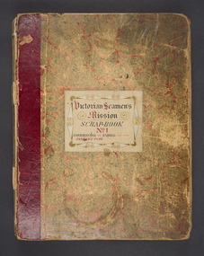
Book (item) - Scrapbook, W.H.C. Darvall, Victorian Seamen's Mission Scrapbook No 1, c.1896
This scrapbook holds numerous newspaper clippings recording events, functions and visits to the Seamen's Mission starting in 1896 through to 1902, although a few documents date from 1895. These dates coincide with the commencement of Mr WHC Darvall's various terms of office with the Mission from the mid 1890s. Mr Darvall's involvement with the Mission possibly stems from his arrival in Victoria in 1853 part working his passage from England as a purser on the migrant ship Asia. He first encountered Captain Pascoe on arrival at Williamstown who was also on the Mission executive when Darvall returned to Melbourne from Beechworth in 1871. 1898: Death of Captain Crawford Pasco with a photographic portrait. 1899: Small ink sketch by artist Charles Georges Darvall, WHC Darvall's cousin. 1900 Foundation of Geelong mission 1901: Queen Victoria's death (22 January) Australian Federation (1st January) Boer War (189-1902) Death of chaplain Ebenezer James Nautical exhibition On the inside of the rear cover of the book a plan of Williamstown has been pasted with no date provided. This scrapbook outlines the many events, concerts, important visits and social occasions held at and by the Mission during this time frame. It includes the names and activities of many prominent Melburnians (politicians, supporters, artists) and shows the vivacity of the work at the Mission.Sticker on the front cover: "Victorian Seamen's/Mission/Scrap-book/No. 1/Commencing/ January 1896 Ending - victoria-missions-to-seamen, w h c darvall, mission to seamen, seamen's mission, maritime exhibition, queen victoria, royal merchant seaman orphanage, charles g. darvall, william henry charles darvall (1830-1906), queen victoria (1819-1901), boer war, charles georges darvall (1831-1924), sunbeam, lord brassey, crawford atchison denman pasco (1818-1898), concerts, library association, merchant seamen orphans asylum, snaresbrook, frederica mitchell, kitty grindlay, syllabus, amateur concerts, port melbourne standard, cole's book arcade, the port gazette, the port melbourne standard, hereward, maitland -
 Flagstaff Hill Maritime Museum and Village
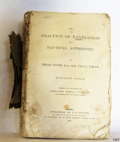
Book - Technical Reference, Henry Raper, Lieut. R.N, The Practice of Navigation and Nautical Astronomy, 1891
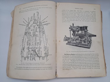
... Flagstaff Hill Maritime Village book navigation nautical astronomy ...This technical textbook is the nineteenth edition of the book by Henry Raper, Lieutenant in the Royal Navy with awards that include F.R.A.S. (Fellow of the Royal Astronomical Society) and F.R.G.S. (Friend of the Royal Geographical Society). The book is dedicated in honour of Rear-Admiral Sir Francis Beaufort K.C.B., Hydrographer to the Admiralty. He was awarded the title K.C.B. (King's Commander) as a Member of the Order of Bath, an order of British Chivalry, The book was first published in 1840 and soon became a resource for navigation students. It includes topics on nautical navigation, astronomy, navigation charts, calculations and mathematical tables, time, tides, ships, longitude, and position at sea. Thomas A. Hull, who revised and expanded this edition, was a Commander in the Royal Navy and had previously been Superintendent of Admiralty Charts used for navigation worldwide by seamen from many walks of life. The publisher, J D Potter of London, was at that time the sole agent for the Admiralty Charts produced by the Royal Navy. Printer Spottswoode and Co.,. was established by William Strachan in 1738. In 1819 his nephews A and R Spottswoode took over the business and bought premises in New-Street Square and Shoe Lane. In 1850 over 200 workers were employed by the firm. and five years later the business became Spottswoode & Co. Andrew Spottswoode invented the Spottswoode Press.This technical book was very popular as a textbook for students of maritime navigation, written and updated by members of the British Royal Navy and relied upon for accurate advice and information. The first edition was published in 1840, this edition was updated, expanded and published in 1891 when ports around the world were filling with travellers, merchants and business people. Title: The Practice of Navigation and Nautical Astronomy Author: Henry Raper, Lieut, R.N., F.R.A.S., F.R.G.S. Nineteenth Edition, revised and enlarged by Commander Thomas A. Hull, R.N., Late Superintendant of Admiralty Charts Dedication: To Rear-Admiral Sir Francis Beaufort K.C.B. Publisher: J D Potter, London, sole agent for the sale of Admiralty Charts Printer: Spottswoode and Co. New-Street Square, London Date: 1891 Small leather hardcover book with gold embossed text and lines on the spine. The Dedication in the book is as follows: - "To Rear-Admiral Sir Francis Beaufort K.C.B. Hydrographer to the Admiralty. Sir, The eminent station which you occupy in the naval scientific world renders it highly gratifying to me to dedicate the following Work to you as a testimony of my regard and esteem; while the general accordance of my views on the subject with those of your more experienced judgement, gives me the greater confidence in laying my labours before the Public. I have the honour to be, Sir, Your obedient servant, HENRY RAPER"flagstaff hill maritime museum, maritime museum, shipwreck coast, flagstaff hill, warrnambool, flagstaff hill maritime village, book, navigation, nautical astronomy, hydrography, nautical charts, nautical navigation, astronomical navigation, admiralty charts, henry raper, thomas a. hull, royal navy, j d potter, royal astronomical society, royal geographical society, calculations, mathematical tables, longitude, latitude, nautical time, location at sea, position at sea, maritime, practical navigation, spottswoode and co., sir francis beaufort, k.c.b., rear-admiral sir francis beaufort, hydrographer to the admiralty, scientific book, naval science -
 Flagstaff Hill Maritime Museum and Village
Book - Textbook, Introduction to Modern Geography
This mid-19th century scientific reference book, Introduction to Modern Geography, explains geography and astronomy using the globe of the world as a teaching aid. The inscription connects this book to the Bobinawarrah Public Library but research to date has found no further details about the library. The rural area was settled in 1859, but in 2016 its population was only 87. It is situated about 21 kilometres south of the City of Wangaratta, in Northeast Victoria. In 2024 the local community received a grant for preservation of its almost 100-year-old Bobinawarrah Memorial Hall which displays an honour board of the Pioneers of Bobinawarrah 1859-1959. The donor of the book lived in Warrnambool. ABOUT THE AUTHOR, James Thomson (1786-1849): - James Thomson was a British Irish mathematician. He became Professor of Mathematics at the University of Glasgow. He wrote many school textbooks and reference books, one of which was Introduction to Modern Geography, first published in Belfast in 1827, and revised and published in over 20 more editions. Thomson tutored two of his several children at home. His older son James Thomson (1822-1892) became an engineer and physicist. His younger son William Thomson (1824-1907) became Professor of Natural Philosophy from 1846-1899 at the University of Glasgow, and later the 1st Baron of Kelvin, famous for his designs of nautical instruments such as the navigational compass and sounding equipment used in the transatlantic installation of sea cable. William was part of the firm that became famous as Kelvin & Hughes Ltd., suppliers of radar and echo sounders to the Ministry of Transport and the Ministry of Defence. The name continued on as Kelvin & Hughes. James Thomson (1786-1849) was a renowned British Irish mathematician and Professor of Mathematics at the University of Glasgow. He was a respected author of many important school books and textbooks that were widely used to provide understanding of arithmetic and geography. Thomson encouraged practical education and held extra classes for young ladies to learn mathematics and geography, which were a novelty at that time. Many of his works were known and used worldwide. This work was published in many editions. It is now considered as culturally significant as a basis for knowledge about our civilisation and has been made publicly available in overseas countries, and republished and reproduced in a readable format, including its diagrams and maps. Book; scientific textbook. The book has a black leather cover. The front cover is blank, but the spine has an embossed gold vertical title within a rectangular border boasting fancy corners. The fly page has a detailed title. The author is James Thomson. It is the Eighteenth edition, published in Simms & McIntyre of London and Belfast in 1845. An inscription connects it to the Bobinawarrah Public Library in Victoria.Spine within a gold border: "THOMSON'S GEOGRAPHY" Fly Page: "AN INTRODUCTION TO MODERN GEOGRAPHY, WITH AN APPENDIX, CONTAINING AN OUTLINE OF ASTRONOMY, AND THE USE OF THE GLOBES. BY JAMES THOMSON, LL.D., PROFESSOR OF MATHEMATICS IN THE UNIVERSITY OF GLASGOW." "Eighteenth Edition" "LONDON: SIMMS AND McINTYRE, ALDINE CHAMBERS, PATERSOSTER ROW; AND DONEGALL -STREET, BELFAST.""1845"flagstaff hill, flagstaff hill maritime museum and village, warrnambool, maritime museum, maritime village, great ocean road, shipwreck coast, introduction to geography, james thomson, reference book, professor thomson's introduction to modern geography, bobinawarrah public library, james thomson mathematician, james thomson engineer, 19th century irish mathematician, irish presbyterian, william thomson 1st baron of kelvin, professor of mathematics, glasgow university, william thomson professor of natural philosophy, introduction to modern geography, outline of astronomy, use of the globes, james thomson ll.d., simms and mcintyre, 1843, scientific book, school book, lord kelvin, baron kelvin of langs, nautical instruments, marine instruments, transatlantic cable, kelvin & hughes, thomson’s geography, astronomy, geography, world globe, cartography, pioneers of bobinawarrah, textbook -
 Flagstaff Hill Maritime Museum and Village
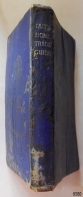
Book - Technical Reference, James Tait, Extra Master and Author et al, Tait's Home Trade Guide to the Board of Trade Examinations for Mates and Masters, 1943
The book includes navigational information, tables and maps, diagrams and formulas. It was written for Examiners and Students studying for their nautical Mates and Masters marine qualifications— notes have been handwritten inside the front and back covers. Notes in point form: 1. I have seen the back of a torpedo EBoat or UBoat in my starboard side 2. I _ _ _ to - - - - - - - - - Port side 3. at a distance ----------- 4. Enemy surface vessel in sight __________ 5. suspicious vessel in sight 6. enemy (undecipherable) 7. I have cut a _ _ _ adrift with my _ _ 8. FI_ _ WISE _ _ _ 9. STARWISE 0. OPEN FIREThis relatively rare book provided up-to-date navigational information during World War II. It was to be used by Examiners to assess whether students qualified to be a Ship's Mate or Ship's Master. The contents of the book were based on maritime knowledge gained over centuries. It is an aid to understanding the navigational methods of the time and the changes and improvements in more recent history.Title: Tait's Home Trade Guide: to the Board of Trade Examinations for Mates and Masters Author: James Tait, Extra Master Publisher: Brown, Son and Ferguson, Ltd. Glasgow, Great Britain Date: Revised Edition 1943 Further Information: Fourteenth Edition 1941, Reprinted Edition 1943. Revised and brought up to date by Captain H. T. Jefferys, Extra Master Printed by Nautical Press, Brown, Son & Ferguson, Limited, 52-58 Darnley Street, Glasgow Hardcover, small book, royal blue cover, silver embossed text on spine. Textbook for Mariners. Includes tables and maps, diagrams and formulas, and navigational information. The inside covers of this book contain handwritten calculations, diagrams and notes that refer to navigation. Notes inside the back cover refer to an enemy vessel and OPEN FIRE.Spint, in silver embossing "TAIT'S HOME TRADE GUIDE" Handwritten inside the back cover "R.A.D. / MOORE / PT. WELCH" Included with the text inside the back cover "Gascoyne" "506" and "RCM"flagstaff hill, warrnambool, shipwrecked coast, flagstaff hill maritime museum, maritime museum, shipwreck coast, flagstaff hill maritime village, great ocean road, james tait, brown, son and ferguson limited, torpedo, open fire, pt welch, vessel gascoyne, e-boat, u-boat, marine technology, world war ii, wwii, ww2, navigation exams, ship's mate, ship's master, wwii textbook, nautical textbook, navigational textbook, examination textbook, world war ii textbook, 1943 nautical textbook -
 Glenelg Shire Council Cultural Collection
Book, Nicholl's Seamanship and Nautical Knowledge
... Seamanship Engineering Nautical reference book Missing the front ...Nautical reference bookMissing the front and back cover and spine. A book detailing different aspects of a nautical nature - training, regulations, flags, ensigns etcnon-fictionNautical reference bookmarine, nautical, seamanship, engineering -
 Glenelg Shire Council Cultural Collection
Book, Pergamon Press, Antarctic Meteorology, 1960
A non-fiction book detailing information about Antarctic weather patterns.Blue Harback 483 page book. Writing on the spine in gold lettering with an image of an ancient Greek (Spartan?) soldier in a circle at the bottom. Two gold lines across the bottom of the spine. The front and back cover are blank. No dust cover. Inside is an order form for ordering more books from the same published - Pergamon Press.non-fictionA non-fiction book detailing information about Antarctic weather patterns.meteorological, weather, antarctic, 1950s, maritime, nautical, portland -
 Glenelg Shire Council Cultural Collection
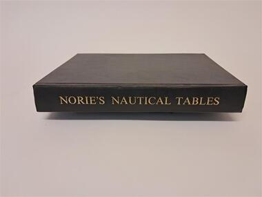
Book - Norie's Nautical Tables, Imray, Laurie, Norie & Wilson Ltd, 1981
... . Nautical Angles Compass Logs Functions This book contains nautical ...This book contains nautical tables such as the Suns Total Correction, Table of the angles of the Mariner's Compass, Traverse Table, Logs. of Trig. Functions, Haversines, Hour angle etc.Black covered hard cover book. 546 pages plus an index.non-fictionThis book contains nautical tables such as the Suns Total Correction, Table of the angles of the Mariner's Compass, Traverse Table, Logs. of Trig. Functions, Haversines, Hour angle etc.nautical, angles, compass, logs, functions -
 Glenelg Shire Council Cultural Collection
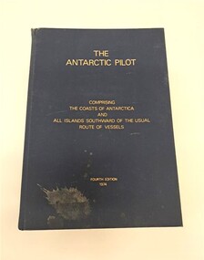
Book, Hydrographer of the Navy, The Antarctic Pilot, 1974
A reference book detailing the coast and islands of AntarcticaNavy blue hardback book. Gold lettering on the front cover and spine. There is a splash of dirt on the bottom lefthand corner of the front cover. The top of the spine is slightly ripped. It describes the coasts of Antarctica and surrounding islands.non-fictionA reference book detailing the coast and islands of Antarcticanaval, navigation, maritime, nautical, antarctica, portland, glenelg, glenelg shire, vessel, research -
 Port Melbourne Historical & Preservation Society
Card - Binder, Piers Festival, Polly Woodside Maritime Museum, c. 1990
These migrant ship cards were used loose by the former Maritime Museum (Polly Woodside), and donated to PMHPS by A Gibson, National Trust Victoria, bound in January 2013 for use in the PMHPS display on migrant ships in Princes Pier GatehouseOne of three sets of laminated information cards, punched and roughly bound into a book for information display at "Piers festival". (.01) - "Angelina Lauro" to "Esperance Bay" (.02) - "Fairsea" to "Moreton Bay" (.03) - "Northern Star" to "Stathmore"The backs of the cards are pasted with sections of nautical maps.transport - shipping, immigration, celebrations fetes and exhibitions, angelina lauro, arcadia, australis, canberra, captain cook, captain hobson, castel felice, chusan, dominion monarch, ellinis, esperance bay, fairsea, fairstar, fairsky, galileo galilei, himilaya, johan van olden barnevelt, largs bay, maasdam, mariposa, moreton bay, northern star, orion, oriana, oronsay, ormonde, orsova, otranto, patris, roma, southern cross, stathaird, statheden, stathmore, ss iberia, ss guglielmo marconi