Showing 41 items
matching nautical navigation
-
 Flagstaff Hill Maritime Museum and Village
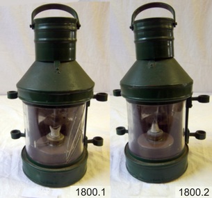
Functional object - Anchor Lamp, Bef. 09-02-1984
The kerosene lamp was one of the most common oil lamps used and was manufactured until the 1980s. An anchor lamp like the lamps in this pair would be raised on the highest ship mast at night to signal other seafarers that the ship was at anchor or sailing at night. The metal loops on opposing sides of the lamp could hold a pair of rods or ropes. and be used to raise the lamp.The lamp is made to the design of a 19th and early 20th-century kerosene anchor lamp carried as essential marine equipment and used as a signal lamp on sailing ships. Lamps; a pair of cylindrical kerosene anchor lamps. Each has a flat back, a hinged door, a metal handle and two metal loops or guides fixed on each side. The glass window is convex and inside the lamp is a wick in an enamel wick holder.brass lamp, lamp, anchor kerosene lamp, kerosene lamp, marine equipment, marine lamp, navigation, light, ship light, ship lamp, lantern, maritime, nautical, safety lamp -
 Flagstaff Hill Maritime Museum and Village
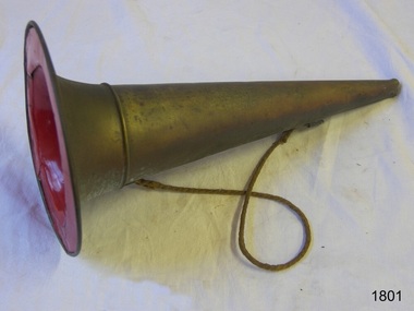
Functional object - Megaphone
... Maritime Museum and Village fog horn marine equipment navigation ...This megaphone's conical shape amplifies the sound from the narrow end and would have been used to signal a warning or give instructions. Its design is similar to an earlier brass fog horn used on a marine vessel, as it has a wide brim that allows it to be free-standing, and a shoulder rope makes it portable and frees up the user's hands. The narrow end is shaped into a mouthpiece. The megaphone may have been used at sea foghorn on a vessel, although it has no reeds for the sound, or used by a leader of a band or a fireman or other similar uses. This megaphone's conical shape is based on the centuries-old ram's horn or horn from other animals, used to amplify sound to make it travel a long distance or be heard above other sounds. It represents a similar instrument made in the 19th century and used as a signal or to give instructions, such as on a vessel at sea, to a lifesaving team, or in a marching band. Megaphone; brass conical shape with an opening at both ends and a join near the wide end. The wide opening has a broad brim and is painted red inside. A brass ring is attached near each opening and a narrow rope is attached to each ring. warrnambool, flagstaff hill maritime museum and village, fog horn, marine equipment, navigation, warning signal, maritime, nautical, fireman, captain, shoulder rope, signal, safety equipment -
 Flagstaff Hill Maritime Museum and Village
Instrument - Azimuth Compass, Early 20th Century
Negretti and Zambra 1850-1980s were optical instrument makers and mathematical instrument makers based in London, England. The firm of Negretti and Zambra was established in 1850 by Henry Negretti and Joseph Zambra who had formed a partnership. Their skill was immediately apparent when exhibiting at the 1851 Great Exhibition at Hyde Park, they were the only English instrument makers to receive a prize medal for meteorological instruments, resulting in their appointment as instrument makers to the queen, Greenwich observatory, and the British Meteorological Society. In 1853, when the Crystal Palace was re-erected in Sydenham, Negretti and Zambra became the official photographers of the Crystal Palace Company, which allowed them to photograph the interior and grounds of the new building. The firm made use of this access to produce a number of stereographs. Between 1855 and 1857 Negretti and Zambra commissioned photographer Pierre Rossier to travel to China to document the Second Opium War. Although Rossier subsequently was unable to accompany to Anglo-French forces in that campaign, he nevertheless produced a number of stereographs and other photographs of China, Japan, the Philippines and Siam (now Thailand), which Negretti and Zambra published and that represented the first commercial photographs of those countries. In 1856 Negretti and Zambra sponsored a photographic expedition to Egypt, Nubia and Ethiopia conducted by Francis Firth. In 1864 Negretti and Zambra (themselves) photographed Shakespeare's House at Stratford on Avon. A sepia photograph was then pasted onto card 4" × 2.5". This was then presented to visitors to the Crystal Palace to enable them to compare it with the model erected by Mr E. T. Parr in the Centre Transept. The card itself is headed "Crystal Palace April 23rd 1864." That year they also published a book, titled A Treatise on Meteorological Instruments, (which was reprinted in 1995). Throughout World War One Negretti and Zambra were entirely engaged in the production of various instruments for the Ministry of Munitions. They developed many instruments for the Air Ministry including a mercury-in-steel distance thermometer for taking the oil and air temperatures in aircraft which was patented in 1920. In 1946 the company went private and in 1948 the company was made public, and by 1950 Negretti and Zambra had 821 employees in Britain. In order to increase production and to safeguard future development in 1964, they purchased a modern factory at Aylesbury for all their production. In 1981 Negretti and Zambra were taken over by a group of financial institutions in the form of Western Scientific Instruments and in 1985 the company was acquired by Meggitt Holdings.The subject compass is just one type of the many marine and scientific, optical items this company produced over it’s life time. Negretti and Zambra were prolific manufactures of types of items as well as being very prominent in photography pioneering new innervation's and sponsoring expeditions to little known countries to document peoples daily lives and culture through photography.Azimuth compass on tripod in a fitted wooden box with a round spirit level included, lid of box has three indented circles where the legs of the compass fit when it is set up for use. Stamped "C.M.O. 9" on with Maker Negretti & Zambra London.flagstaff hill, warrnambool, flagstaff-hill, flagstaff-hill-maritime-museum, shipwreck-coast, flagstaff-hill-maritime-village, azimuth compass, nautical instrument, negretti & zambra london, navigational instrument, compass -
 Flagstaff Hill Maritime Museum and Village
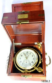
Instrument - Chronometer
First State Watch Factory: This factory was founded in 1930 under orders from Joseph Stalin, the "First State Watch Factory" was the first large-scale Soviet watch and mechanical movement manufacturer in the USSR. Via its USA-based trading company (Amtorg), the Soviet government bought the defunct Ansonia Clock Company of Brooklyn, New York in 1929, and the "Dueber-Hampden Watch Company of Canton", based in Ohio. The soviets moved twenty-eight freight cars full of machinery and parts from the USA to Moscow in order to establish the factory. Twenty-one former "Dueber-Hampden" watchmakers, engravers and various other technicians helped to train the Russian workers in the art of watchmaking as part of the Soviet's first five-year plan. The movements of very-early products were still stamped "Dueber-Hampden, Canton, Ohio, USA" (examples of these watches are very collectible today). In 1935 the factory was named after the murdered Soviet official Sergei Kirov. During the second world war, as the Germans closed in on Moscow in 1941, the factory was hurriedly evacuated to (Zlatoust USSR). By 1943 the Germans were in retreat, and the factory was moved back to Moscow, adopting the "First Moscow Watch Factory" name. In 1947 the first wristwatches under the brand name "Pobeda" and the first Marine Chronometers and Deck watches were produced. By 1951 the production of wristwatches had increased to 1.1 million. In 1975 new machinery and equipment for manufacturing complex watches were imported from Switzerland. The first chronograph called "Okean" (3133) was produced for the space station "Soyuz-23."The Chronometer is of recent manufacture and an excellent example of the type of instrument used to navigate the seas in the 19th century. It is of good quality and of a type regarded as very accurate and well made. The maker, First Watch Factory, has a dept that is still producing the "8916" standard Chronometer for horologists and collectors. Marine chronometer of Russian make in wooden case, metal handles on sides, inscription on a metal plaque on the front of the case. Polished square wooden outer case with green felt lining and, a leather carrying strap and buckle. Outer case is hinged and has a metal latch on the front. Outer case has a red velvet covering with a button and loop closure. Inscription on box are in Russian & translate as follows: ХРОНОМЕТР, = CHRONOMETER МОРСКОЙ, = NAUTICAL ГОСТ, 8916-77 = Gost ЛОЛ ЕТ, on dial face = LOL ETflagstaff hill, warrnambool, shipwrecked-coast, flagstaff-hill, flagstaff-hill-maritime-museum, maritime-museum, shipwreck-coast, flagstaff-hill-maritime-village, chonometer, russian, watch factory, marine, navigational instrument -
 Federation University Historical Collection
Book, William Collins, Sons, & Company, Elementary Treatise on Nautical Astronomy for the Use of Science Classes and Seamen, 1873, 1873
Small book with dark green embossed fabric hard cover with 144 pagesnon-fictionhenry evers, navigation, chronometer, astronomy, index error, vernier, meridian, elementary school, science class, sextant, zodiac, sailing -
Moorabbin Air Museum
Book - ASTRONOMICAL NAVIGATION TABLES, H.M. NAUTICAL ALMANAC OFFICE ON BEHALF OF THE AIR MINISTRY, NO DATE
... NAVIGATION TABLES H.M. NAUTICAL ALMANAC OFFICE ON BEHALF OF THE AIR ... -
Moorabbin Air Museum
Book - ASTRONOMICAL NAVIGATION TABLES
... NAVIGATION TABLES H.M. NAUTICAL ALMANAC OFFICE ON BEHALF OF THE AIR ... -
 Mission to Seafarers Victoria
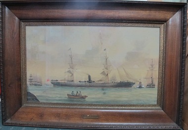
Painting, George Frederick Gregory (1821-1887), P&O S.S. Bangalore, 1867 - 1886
This ship was number 1 of 2 ships named Bangalore and run by P & O. This ship has listed the same tonnage as that on the inscription on the frame of this work. The ship was subsequently sold in 1886 sold to Hajee Cassum Joosub and used for passengers on pilgrimage into Jeddah. Another view of the history of the Bangalore is that to be found at the Maritime Museums of Sydney listing of another painting of the Bangalore which provides a somewhat different history. It is possible that the story of Bangalore 1 and Bangalore 2 have become conflated further research is needed to verify. see Links field. SS BANGALORE was built in 1867 by William Denny of Dumbarton. Owned by P&O, SS BANGALORE operated from Bombay and Galle to Melbourne and Sydney from 1872 to 1886 as a passenger and mail ship. In 1891 BANGALORE was sold to Wilh. Wilhelmsen, Norway and renamed SS CORINGA.Marine art, Maritime artP&O S.S. Bangalore by George Frederick Gregory (1821-1887)Thinly painted image on board featuring centrally a moored, at anchor, 19th C dual masted steamship with black funnel and flying at the stern a red ensign. To either side are conventional rigged clippers or sailing ships. Near the bow of the steamship there seems to be a tug or paddle steamer face on. In the foreground is a small rowing boat with boatman and two passengers, a male and a female. The painting on board is mounted in a large polished or varnished cedarwood frame with edge carving and a decorative pitted slip which holds in place a thin piece of glazing. Backing paper and seal has all been removed except for hanging wire. Central at front lower edge of frame is a small chipped wood plaque with inscription.Painted in black on plaque and coloured black: "P & O S.S. "BANGALORE" / 2342 tons Built 1867"s.s. bangalore, marine painting, sailing ships, 1867, william denny, artwork-paintings, peninsular and oriental steam navigation company, steamship, p&o, sandridge, port melbourne, hobson's bay, charles dickson gregory, centenary maritime exhibition, george frederick gregory (1821-1887), ss bangalore -
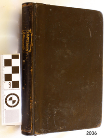 Flagstaff Hill Maritime Museum and Village
Book - Textbook, Introduction to Modern Geography
This mid-19th century scientific reference book, Introduction to Modern Geography, explains geography and astronomy using the globe of the world as a teaching aid. The inscription connects this book to the Bobinawarrah Public Library but research to date has found no further details about the library. The rural area was settled in 1859, but in 2016 its population was only 87. It is situated about 21 kilometres south of the City of Wangaratta, in Northeast Victoria. In 2024 the local community received a grant for preservation of its almost 100-year-old Bobinawarrah Memorial Hall which displays an honour board of the Pioneers of Bobinawarrah 1859-1959. The donor of the book lived in Warrnambool. ABOUT THE AUTHOR, James Thomson (1786-1849): - James Thomson was a British Irish mathematician. He became Professor of Mathematics at the University of Glasgow. He wrote many school textbooks and reference books, one of which was Introduction to Modern Geography, first published in Belfast in 1827, and revised and published in over 20 more editions. Thomson tutored two of his several children at home. His older son James Thomson (1822-1892) became an engineer and physicist. His younger son William Thomson (1824-1907) became Professor of Natural Philosophy from 1846-1899 at the University of Glasgow, and later the 1st Baron of Kelvin, famous for his designs of nautical instruments such as the navigational compass and sounding equipment used in the transatlantic installation of sea cable. William was part of the firm that became famous as Kelvin & Hughes Ltd., suppliers of radar and echo sounders to the Ministry of Transport and the Ministry of Defence. The name continued on as Kelvin & Hughes. James Thomson (1786-1849) was a renowned British Irish mathematician and Professor of Mathematics at the University of Glasgow. He was a respected author of many important school books and textbooks that were widely used to provide understanding of arithmetic and geography. Thomson encouraged practical education and held extra classes for young ladies to learn mathematics and geography, which were a novelty at that time. Many of his works were known and used worldwide. This work was published in many editions. It is now considered as culturally significant as a basis for knowledge about our civilisation and has been made publicly available in overseas countries, and republished and reproduced in a readable format, including its diagrams and maps. Book; scientific textbook. The book has a black leather cover. The front cover is blank, but the spine has an embossed gold vertical title within a rectangular border boasting fancy corners. The fly page has a detailed title. The author is James Thomson. It is the Eighteenth edition, published in Simms & McIntyre of London and Belfast in 1845. An inscription connects it to the Bobinawarrah Public Library in Victoria.Spine within a gold border: "THOMSON'S GEOGRAPHY" Fly Page: "AN INTRODUCTION TO MODERN GEOGRAPHY, WITH AN APPENDIX, CONTAINING AN OUTLINE OF ASTRONOMY, AND THE USE OF THE GLOBES. BY JAMES THOMSON, LL.D., PROFESSOR OF MATHEMATICS IN THE UNIVERSITY OF GLASGOW." "Eighteenth Edition" "LONDON: SIMMS AND McINTYRE, ALDINE CHAMBERS, PATERSOSTER ROW; AND DONEGALL -STREET, BELFAST.""1845"flagstaff hill, flagstaff hill maritime museum and village, warrnambool, maritime museum, maritime village, great ocean road, shipwreck coast, introduction to geography, james thomson, reference book, professor thomson's introduction to modern geography, bobinawarrah public library, james thomson mathematician, james thomson engineer, 19th century irish mathematician, irish presbyterian, william thomson 1st baron of kelvin, professor of mathematics, glasgow university, william thomson professor of natural philosophy, introduction to modern geography, outline of astronomy, use of the globes, james thomson ll.d., simms and mcintyre, 1843, scientific book, school book, lord kelvin, baron kelvin of langs, nautical instruments, marine instruments, transatlantic cable, kelvin & hughes, thomson’s geography, astronomy, geography, world globe, cartography, pioneers of bobinawarrah, textbook -
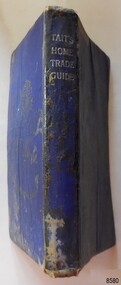 Flagstaff Hill Maritime Museum and Village
Book - Technical Reference, James Tait, Extra Master and Author et al, Tait's Home Trade Guide to the Board of Trade Examinations for Mates and Masters, 1943
... textbook nautical textbook navigational textbook examination ...The book includes navigational information, tables and maps, diagrams and formulas. It was written for Examiners and Students studying for their nautical Mates and Masters marine qualifications— notes have been handwritten inside the front and back covers. Notes in point form: 1. I have seen the back of a torpedo EBoat or UBoat in my starboard side 2. I _ _ _ to - - - - - - - - - Port side 3. at a distance ----------- 4. Enemy surface vessel in sight __________ 5. suspicious vessel in sight 6. enemy (undecipherable) 7. I have cut a _ _ _ adrift with my _ _ 8. FI_ _ WISE _ _ _ 9. STARWISE 0. OPEN FIREThis relatively rare book provided up-to-date navigational information during World War II. It was to be used by Examiners to assess whether students qualified to be a Ship's Mate or Ship's Master. The contents of the book were based on maritime knowledge gained over centuries. It is an aid to understanding the navigational methods of the time and the changes and improvements in more recent history.Title: Tait's Home Trade Guide: to the Board of Trade Examinations for Mates and Masters Author: James Tait, Extra Master Publisher: Brown, Son and Ferguson, Ltd. Glasgow, Great Britain Date: Revised Edition 1943 Further Information: Fourteenth Edition 1941, Reprinted Edition 1943. Revised and brought up to date by Captain H. T. Jefferys, Extra Master Printed by Nautical Press, Brown, Son & Ferguson, Limited, 52-58 Darnley Street, Glasgow Hardcover, small book, royal blue cover, silver embossed text on spine. Textbook for Mariners. Includes tables and maps, diagrams and formulas, and navigational information. The inside covers of this book contain handwritten calculations, diagrams and notes that refer to navigation. Notes inside the back cover refer to an enemy vessel and OPEN FIRE.Spint, in silver embossing "TAIT'S HOME TRADE GUIDE" Handwritten inside the back cover "R.A.D. / MOORE / PT. WELCH" Included with the text inside the back cover "Gascoyne" "506" and "RCM"flagstaff hill, warrnambool, shipwrecked coast, flagstaff hill maritime museum, maritime museum, shipwreck coast, flagstaff hill maritime village, great ocean road, james tait, brown, son and ferguson limited, torpedo, open fire, pt welch, vessel gascoyne, e-boat, u-boat, marine technology, world war ii, wwii, ww2, navigation exams, ship's mate, ship's master, wwii textbook, nautical textbook, navigational textbook, examination textbook, world war ii textbook, 1943 nautical textbook -
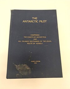 Glenelg Shire Council Cultural Collection
Book, Hydrographer of the Navy, The Antarctic Pilot, 1974
... also worked for Shore Line Engineering. Naval Navigation ...A reference book detailing the coast and islands of AntarcticaNavy blue hardback book. Gold lettering on the front cover and spine. There is a splash of dirt on the bottom lefthand corner of the front cover. The top of the spine is slightly ripped. It describes the coasts of Antarctica and surrounding islands.non-fictionA reference book detailing the coast and islands of Antarcticanaval, navigation, maritime, nautical, antarctica, portland, glenelg, glenelg shire, vessel, research