Showing 149 items
matching norman england
-
 Ballarat Heritage Services
Photograph - Colour, Entrance to Public toilets hidden in earth mound, Old Sarum, England, English Heritage Site, 2016, 01 November 2016
... Saxon king of England. It was an ideal site for a royal castle... Saxon king of England. It was an ideal site for a royal castle ...William the Conqueror inherited Old Sarum from the last Saxon king of England. It was an ideal site for a royal castle. It was here in 1070 that William paid off his army after a long and bitter campaign in northern England. It was here in 1086 that he called together all the major landholders in England so they could swear allegiance to him. It was a crucial moment. The Domesday Book was being written, a threatened Viking invasion had only just been averted and William's eldest son was in armed rebellion. Old Sarum was an important place where this Norman king of England held power. In 1794 the Ordnance Survey set out to check the accuracy of the first mapping of Southern England, which had begun ten years earlier. From a point just below Old Sarum Lieutenant William Mudge laid out a base-line 36,574 feet (11,253 metres) long. From each end of the line the positions of distant places were plotted using a huge theodolite made in 1791 by Jesse Ramsden. The accuracy of the process, which was repeated all over England, depended on Jesse Ramsden's craftsmanship and on William Mudge's surveying skill in setting out this first base-line from Old Sarum. The nearer end of Mudge's line is marked by an inscribed stone beside the modern A345 at Old Sarum. ordnance survey, william mudge, jesse ramsden, william the conqueror, old sarum, saxon, 1086, england -
 Ballarat Heritage Services
Photograph - Colour, Masons' Marks, Old Sarum, England, English Heritage Site, 2016, 01 November 2016
... Saxon king of England. It was an ideal site for a royal castle... where this Norman king of England held power. In 1794 ...William the Conqueror inherited Old Sarum from the last Saxon king of England. It was an ideal site for a royal castle. It was here in 1070 that William paid off his army after a long and bitter campaign in northern England. It was here in 1086 that he called together all the major landholders in England so they could swear allegiance to him. It was a crucial moment. The Domesday Book was being written, a threatened Viking invasion had only just been averted and William's eldest son was in armed rebellion. Old Sarum was an important place where this Norman king of England held power. In 1794 the Ordnance Survey set out to check the accuracy of the first mapping of Southern England, which had begun ten years earlier. From a point just below Old Sarum Lieutenant William Mudge laid out a base-line 36,574 feet (11,253 metres) long. From each end of the line the positions of distant places were plotted using a huge theodolite made in 1791 by Jesse Ramsden. The accuracy of the process, which was repeated all over England, depended on Jesse Ramsden's craftsmanship and on William Mudge's surveying skill in setting out this first base-line from Old Sarum. The nearer end of Mudge's line is marked by an inscribed stone beside the modern A345 at Old Sarum. ordnance survey, william mudge, jesse ramsden, william the conqueror, old sarum, saxon, 1086, england -
 Ballarat Heritage Services
Photograph - Colour, Old Sarum, England, 2017, 01 November 2016
... Saxon king of England. It was an ideal site for a royal castle... was an important place where this Norman king of England held power ...William the Conqueror inherited Old Sarum from the last Saxon king of England. It was an ideal site for a royal castle. It was here in 1070 that William paid off his army after a long and bitter campaign in northern England. It was here in 1086 that he called together all the major landholders in England so they could swear allegiance to him. It was a crucial moment. The Domesday Book was being written, a threatened Viking invasion had only just been averted and William's eldest son was in armed rebellion. Old Sarum was an important place where this Norman king of England held power. In 1794 the Ordnance Survey set out to check the accuracy of the first mapping of Southern England, which had begun ten years earlier. From a point just below Old Sarum Lieutenant William Mudge laid out a base-line 36,574 feet (11,253 metres) long. From each end of the line the positions of distant places were plotted using a huge theodolite made in 1791 by Jesse Ramsden. The accuracy of the process, which was repeated all over England, depended on Jesse Ramsden's craftsmanship and on William Mudge's surveying skill in setting out this first base-line from Old Sarum. The nearer end of Mudge's line is marked by an inscribed stone beside the modern A345 at Old Sarum. ordnance survey, william mudge, jesse ramsden, william the conqueror, old sarum, saxon, 1086, england -
 Ballarat Heritage Services
Photograph - Photograph - Colour, Old Sarum, England, 2016, 01/11/2016
... Saxon king of England. It was an ideal site for a royal castle... where this Norman king of England held power. In 1794 ...William the Conqueror inherited Old Sarum from the last Saxon king of England. It was an ideal site for a royal castle. It was here in 1070 that William paid off his army after a long and bitter campaign in northern England. It was here in 1086 that he called together all the major landholders in England so they could swear allegiance to him. It was a crucial moment. The Domesday Book was being written, a threatened Viking invasion had only just been averted and William's eldest son was in armed rebellion. Old Sarum was an important place where this Norman king of England held power. In 1794 the Ordnance Survey set out to check the accuracy of the first mapping of Southern England, which had begun ten years earlier. From a point just below Old Sarum Lieutenant William Mudge laid out a base-line 36,574 feet (11,253 metres) long. From each end of the line the positions of distant places were plotted using a huge theodolite made in 1791 by Jesse Ramsden. The accuracy of the process, which was repeated all over England, depended on Jesse Ramsden's craftsmanship and on William Mudge's surveying skill in setting out this first base-line from Old Sarum. The nearer end of Mudge's line is marked by an inscribed stone beside the modern A345 at Old Sarum. Colour photograph of Old Sarum, England.ordnance survey, william mudge, jesse ramsden, william the conqueror, old sarum, saxon, 1086, england -
 Ballarat Heritage Services
Photograph - Colour, Earth Banks, Old Sarum, England, 01 November 2016
... Saxon king of England. It was an ideal site for a royal castle..., England William the Conqueror inherited Old Sarum from the last ...William the Conqueror inherited Old Sarum from the last Saxon king of England. It was an ideal site for a royal castle. It was here in 1070 that William paid off his army after a long and bitter campaign in northern England. It was here in 1086 that he called together all the major landholders in England so they could swear allegiance to him. It was a crucial moment. The Domesday Book was being written, a threatened Viking invasion had only just been averted and William's eldest son was in armed rebellion. Old Sarum was an important place where this Norman king of England held power. In 1794 the Ordnance Survey set out to check the accuracy of the first mapping of Southern England, which had begun ten years earlier. From a point just below Old Sarum Lieutenant William Mudge laid out a base-line 36,574 feet (11,253 metres) long. From each end of the line the positions of distant places were plotted using a huge theodolite made in 1791 by Jesse Ramsden. The accuracy of the process, which was repeated all over England, depended on Jesse Ramsden's craftsmanship and on William Mudge's surveying skill in setting out this first base-line from Old Sarum. The nearer end of Mudge's line is marked by an inscribed stone beside the modern A345 at Old Sarum. ordnance survey, william mudge, jesse ramsden, william the conqueror, old sarum, saxon, 1086, england -
 Ballarat Heritage Services
Photograph - Colour, Dorothy Wickham, Earth Banks, Old Sarum, England, 2016, 01 November 2016
... Saxon king of England. It was an ideal site for a royal castle... this Norman king of England held power. In 1794 the Ordnance Survey ...William the Conqueror inherited Old Sarum from the last Saxon king of England. It was an ideal site for a royal castle. It was here in 1070 that William paid off his army after a long and bitter campaign in northern England. It was here in 1086 that he called together all the major landholders in England so they could swear allegiance to him. It was a crucial moment. The Domesday Book was being written, a threatened Viking invasion had only just been averted and William's eldest son was in armed rebellion. Old Sarum was an important place where this Norman king of England held power. In 1794 the Ordnance Survey set out to check the accuracy of the first mapping of Southern England, which had begun ten years earlier. From a point just below Old Sarum Lieutenant William Mudge laid out a base-line 36,574 feet (11,253 metres) long. From each end of the line the positions of distant places were plotted using a huge theodolite made in 1791 by Jesse Ramsden. The accuracy of the process, which was repeated all over England, depended on Jesse Ramsden's craftsmanship and on William Mudge's surveying skill in setting out this first base-line from Old Sarum. The nearer end of Mudge's line is marked by an inscribed stone beside the modern A345 at Old Sarum. King William devised the Domesday Book, considered to be the first listing of land owners in England. Among the names is that of D'Arques, from Normandy, France. Descendants of this family later emigrated from England and settled in Victoria, Australia under the surname 'Dark'. ordnance survey, william mudge, jesse ramsden, william the conqueror, old sarum, saxon, 1086, england -
 Ballarat Heritage Services
Photograph - Colour, Earth Banks, Old Sarum, England, 2016, 01 November 2016
... Saxon king of England. It was an ideal site for a royal castle... this Norman king of England held power. In 1794 the Ordnance Survey ...William the Conqueror inherited Old Sarum from the last Saxon king of England. It was an ideal site for a royal castle. It was here in 1070 that William paid off his army after a long and bitter campaign in northern England. It was here in 1086 that he called together all the major landholders in England so they could swear allegiance to him. It was a crucial moment. The Domesday Book was being written, a threatened Viking invasion had only just been averted and William's eldest son was in armed rebellion. Old Sarum was an important place where this Norman king of England held power. In 1794 the Ordnance Survey set out to check the accuracy of the first mapping of Southern England, which had begun ten years earlier. From a point just below Old Sarum Lieutenant William Mudge laid out a base-line 36,574 feet (11,253 metres) long. From each end of the line the positions of distant places were plotted using a huge theodolite made in 1791 by Jesse Ramsden. The accuracy of the process, which was repeated all over England, depended on Jesse Ramsden's craftsmanship and on William Mudge's surveying skill in setting out this first base-line from Old Sarum. The nearer end of Mudge's line is marked by an inscribed stone beside the modern A345 at Old Sarum. ordnance survey, william mudge, jesse ramsden, william the conqueror, old sarum, saxon, 1086, england -
 Ballarat Heritage Services
Photograph - Photograph - Colour, Castle toilets, Old Sarum, England, 2016, 01/11/2016
... Saxon king of England. It was an ideal site for a royal castle... was an important place where this Norman king of England held power ...William the Conqueror inherited Old Sarum from the last Saxon king of England. It was an ideal site for a royal castle. It was here in 1070 that William paid off his army after a long and bitter campaign in northern England. It was here in 1086 that he called together all the major landholders in England so they could swear allegiance to him. It was a crucial moment. The Domesday Book was being written, a threatened Viking invasion had only just been averted and William's eldest son was in armed rebellion. Old Sarum was an important place where this Norman king of England held power. In 1794 the Ordnance Survey set out to check the accuracy of the first mapping of Southern England, which had begun ten years earlier. From a point just below Old Sarum Lieutenant William Mudge laid out a base-line 36,574 feet (11,253 metres) long. From each end of the line the positions of distant places were plotted using a huge theodolite made in 1791 by Jesse Ramsden. The accuracy of the process, which was repeated all over England, depended on Jesse Ramsden's craftsmanship and on William Mudge's surveying skill in setting out this first base-line from Old Sarum. The nearer end of Mudge's line is marked by an inscribed stone beside the modern A345 at Old Sarum. Colour photographs of Castle toilets at Old Sarum, England. The toilets are constructed of stone. ordnance survey, william mudge, jesse ramsden, william the conqueror, old sarum, saxon, 1086, england, subjects, toilets -
 Ballarat Heritage Services
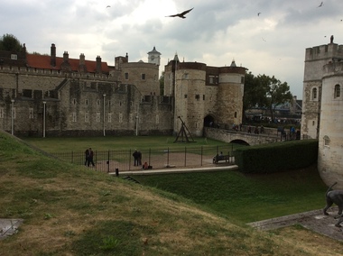
Digital photograph, Dorothy Wickham, Tower of London, 2016
... of the Norman Conquest of England. The White Tower, which gives... of the Norman Conquest of England. The White Tower, which gives ...The Tower of London, officially Her Majesty's Royal Palace and Fortress of the Tower of London, is a historic castle located on the north bank of the River Thames in central London. It lies within the London Borough of Tower Hamlets, separated from the eastern edge of the square mile of the City of London by the open space known as Tower Hill. It was founded towards the end of 1066 as part of the Norman Conquest of England. The White Tower, which gives the entire castle its name, was built by William the Conqueror in 1078, and was a resented symbol of oppression, inflicted upon London by the new ruling elite. The castle was used as a prison from 1100 (Ranulf Flambard) until 1952 (Kray twins),[3] although that was not its primary purpose. A grand palace early in its history, it served as a royal residence. As a whole, the Tower is a complex of several buildings set within two concentric rings of defensive walls and a moat. There were several phases of expansion, mainly under Kings Richard the Lionheart, Henry III, and Edward I in the 12th and 13th centuries. The general layout established by the late 13th century remains despite later activity on the site. The Tower of London has played a prominent role in English history. It was besieged several times, and controlling it has been important to controlling the country. The Tower has served variously as an armoury, a treasury, a menagerie, the home of the Royal Mint, a public record office, and the home of the Crown Jewels of England. From the early 14th century until the reign of Charles II, a procession would be led from the Tower to Westminster Abbey on the coronation of a monarch. In the absence of the monarch, the Constable of the Tower is in charge of the castle. This was a powerful and trusted position in the medieval period. In the late 15th century the castle was the prison of the Princes in the Tower. Under the Tudors, the Tower became used less as a royal residence, and despite attempts to refortify and repair the castle its defences lagged behind developments to deal with artillery. The peak period of the castle's use as a prison was the 16th and 17th centuries, when many figures who had fallen into disgrace, such as Elizabeth I before she became queen, Sir Walter Raleigh, and Elizabeth Throckmorton were held within its walls. This use has led to the phrase "sent to the Tower". Despite its enduring reputation as a place of torture and death, popularised by 16th-century religious propagandists and 19th-century writers, only seven people were executed within the Tower before the World Wars of the 20th century. Executions were more commonly held on the notorious Tower Hill to the north of the castle, with 112 occurring there over a 400-year period. In the latter half of the 19th century, institutions such as the Royal Mint moved out of the castle to other locations, leaving many buildings empty. Anthony Salvin and John Taylor took the opportunity to restore the Tower to what was felt to be its medieval appearance, clearing out many of the vacant post-medieval structures. In the First and Second World Wars, the Tower was again used as a prison, and witnessed the executions of 12 men for espionage. After the Second World War, damage caused during the Blitz was repaired, and the castle reopened to the public. Today the Tower of London is one of the country's most popular tourist attractions. Under the ceremonial charge of the Constable of the Tower, it is cared for by the charity Historic Royal Palaces and is protected as a World Heritage Site.(Wikipedia) A World Heritage Site is a landmark which has been officially recognized by the United Nations, specifically by UNESCO. Sites are selected on the basis of having cultural, historical, scientific or some other form of significance, and they are legally protected by international treaties. UNESCO regards these sites as being important to the collective interests of humanity. More specifically, a World Heritage Site is an already classified landmark on the earth, which by way of being unique in some respect as a geographically and historically identifiable piece is of special cultural or physical significance (such as either due to hosting an ancient ruins or some historical structure, building, city, complex, desert, forest, island, lake, monument, or mountain) and symbolizes a remarkable footprint of extreme human endeavour often coupled with some act of indisputable accomplishment of humanity which then serves as a surviving evidence of its intellectual existence on the planet. And with an ignoble intent of its practical conservation for posterity, but which otherwise could be subject to inherent risk of endangerment from human or animal trespassing, owing to unmonitored/uncontrolled/unrestricted nature of access or threat by natural or accelerated extinction owing to local administrative negligence, hence it would have been listed and demarcated by the United Nations Educational, Scientific and Cultural Organization (UNESCO) to have been identified or recognised and officially christened and internationally elevated through multilateral declaration by UNESCO as a universally protected zone. [1] The list is maintained by the international World Heritage Programme administered by the UNESCO World Heritage Committee, composed of 21 UNESCO member states which are elected by the General Assembly. (Wikipedia)The Tower of London is a UNESCO world heritage site.tower of london -
 City of Moorabbin Historical Society (Operating the Box Cottage Museum)
Photograph, B&W, Anna Box 1849 - 1919, c1912
Anna Box 1849- 1919 was born in Withyham, Sussex England had her 7th birthday en route from Liverpool to Australia. George Box 1808-1867 of Sussex England, married Mary Cripps in 1831 and with 3 three of their 4 four sons and 3 three of their 4 four daughters left Liverpool in the Sailing Ship 'Atlanta' in March 1856 to begin a new life in Melbourne, Victoria , Australia. Their baby daughter Cecilia Lydia died a few days later. Caroline Box, the eldest daughter, remained in England working as a cook until she joined the family in Australia in 1863. William Box 1834-1902, the eldest son of George Box, married Elizabeth Avis 1833- 1914 and they resided in Box Cottage 1865 -1914 where they established a market garden and raised 13 children. William and Elizabeth had emigrated in 1854 so George worked on their market garden before setting up in Patterson Road. Sadly Mary drowned in a water hole only 4 months after their arrival in Brighton. It is supposed that Elizabeth helped George raise the children while he established his market garden. George died from Tetanus following an infected broken leg caused by falling from his dray in 1867. Anna was a dressmaker and in 1881 she married Henry Pay , a painter, from London and they had 3 children . In 1907 the family lived on a 30acre property in Ringwood. which Anna bequeathed to her children. – Beatrice, Norman and Laura. In 1911 they moved to Surrey Hills where Anna died in 1919. Henry died in 1935 in Montrose where he was living with his son Norman Henry Pay, a farmer . Box Cottage Museum, a reconstruction of an early settler hut, is named after the Box family who resided there 1865 -1913 . William Box who, with his wife Elizabeth Avis Box and 13 children, lived and farmed on the block of land in Jasper Road, East Brighton ( now McKinnon / Ormond) that was part of the Henry Dendy Special Survey 1841. George Box 1808-1867 migrated in 1856 and worked with his son William Box until he established a market garden in Patterson Rd . East Brighton ( now Bentleigh). Anna Box –Pay was the 3rd daughter of George and Mary Box. A black and white photograph of Anna Box 1849-1919nilbox anna, pay henry, pay norman, box william, box elizabeth avis, box george, box mary, moorabbin, bentleigh, brighton, ormond, market gardeners, pioneers, early settlers, withyham sussex england, ringwood melbourne, pay beatrice, pay laura, st kilda, melbourne, -
 City of Moorabbin Historical Society (Operating the Box Cottage Museum)
Photograph - Photographs x2, B&W, possibly Anna Box and Henry Pay, c1881
Anna Box 1849- 1919 was born in Withyham, Sussex England had her 7th birthday en route from Liverpool to Australia. George Box 1808-1867 of Sussex England, married Mary Cripps in 1831 and with 3 three of their 4 four sons and 3 three of their 4 four daughters left Liverpool in the Sailing Ship 'Atlanta' in March 1856 to begin a new life in Melbourne, Victoria , Australia. Their baby daughter Cecilia Lydia died a few days later. Caroline Box, the eldest daughter, remained in England working as a cook until she joined the family in Australia in 1863. William Box 1834-1902, the eldest son of George Box, married Elizabeth Avis 1833- 1914 and they resided in Box Cottage 1865 -1914 where they established a market garden and raised 13 children. William and Elizabeth had emigrated in 1854 so George worked on their market garden before setting up in Patterson Road. Sadly Mary drowned in a water hole only 4 months after their arrival in Brighton. It is supposed that Elizabeth helped George raise the children while he established his market garden. George died from Tetanus following an infected broken leg caused by falling from his dray in 1867. Anna was a dressmaker and in 1881 she married Henry Pay , a painter, from London and they had 3 children . In 1907 the family lived on a 30acre property in Ringwood which Anna bequeathed to her children. – Beatrice, Norman and Laura. In 1911 they moved to Surrey Hills where Anna died in 1919. Henry died in 1935 in Montrose where he was living with his son Norman Henry Pay, a farmer . Box Cottage Museum, a reconstruction of an early settler hut, is named after the Box family who resided there 1865 -1913 . William Box who, with his wife Elizabeth Avis Box and 13 children, lived and farmed on the block of land in Jasper Road, East Brighton ( now McKinnon / Ormond) that was part of the Henry Dendy Special Survey 1841. George Box 1808-1867 migrated in 1856 and worked with his son William Box until he established a market garden in Patterson Rd . East Brighton ( now Bentleigh). Anna Box –Pay was the 3rd daughter of George and Mary Box. 2 black and white photographs that may be of A ) Anna Box and B) her husband Henry Pay A) nil B) J P LIND Photo 82 Swanston St.box anna, pay henry, pay norman, box william, box elizabeth avis, box george, box mary, moorabbin, bentleigh, brighton, ormond, market gardeners, pioneers, early settlers, withyham sussex england, ringwood melbourne, pay beatrice, pay laura, st kilda, melbourne -
 City of Moorabbin Historical Society (Operating the Box Cottage Museum)
Photographs, 2 x B&W, possibly Anna Box 1849 - 1919, c1880
Anna Box 1849- 1919 was born in Withyham, Sussex England had her 7th birthday en route from Liverpool to Australia. George Box 1808-1867 of Sussex England, married Mary Cripps in 1831 and with 3 three of their 4 four sons and 3 three of their 4 four daughters left Liverpool in the Sailing Ship 'Atlanta' in March 1856 to begin a new life in Melbourne, Victoria , Australia. Their baby daughter Cecilia Lydia died a few days later. Caroline Box, the eldest daughter, remained in England working as a cook until she joined the family in Australia in 1863. William Box 1834-1902, the eldest son of George Box, married Elizabeth Avis 1833- 1914 and they resided in Box Cottage 1865 -1914 where they established a market garden and raised 13 children. William and Elizabeth had emigrated in 1854 so George worked on their market garden before setting up in Patterson Road. Sadly Mary drowned in a water hole only 4 months after their arrival in Brighton. It is supposed that Elizabeth helped George raise the children while he established his market garden. George died from Tetanus following an infected broken leg caused by falling from his dray in 1867. Anna was a dressmaker and in 1881 she married Henry Pay , a painter, from London and they had 3 children . In 1907 the family lived on a 30acre property in Ringwood. which Anna bequeathed to her children. – Beatrice, Norman and Laura. In 1911 they moved to Surrey Hills where Anna died in 1919. Henry died in 1935 in Montrose where he was living with his son Norman Henry Pay, a farmer . Box Cottage Museum, a reconstruction of an early settler hut, is named after the Box family who resided there 1865 -1913 . William Box who, with his wife Elizabeth Avis Box and 13 children, lived and farmed on the block of land in Jasper Road, East Brighton ( now McKinnon / Ormond) that was part of the Henry Dendy Special Survey 1841. George Box 1808-1867 migrated in 1856 and worked with his son William Box until he established a market garden in Patterson Rd . East Brighton ( now Bentleigh). Anna Box –Pay was the 3rd daughter of George and Mary Box. 2 black and white photographs that Avis Box Leigh thinks may be Anna Box c1880A unreadable B Ferry 49 Elizabeth St . Melbournebox anna, pay henry, pay norman, box william, box elizabeth avis, box george, box mary, moorabbin, bentleigh, brighton, ormond, market gardeners, pioneers, early settlers, withyham sussex england, ringwood melbourne, pay beatrice, pay laura, st kilda, melbourne -
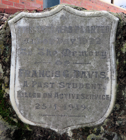
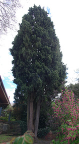 Federation University Historical Collection
Photograph - Colour, Memorial to Francis Davis in the grounds of Federation University, SMB Campus, 2012, 20/09/2012
Francis Gordon Davis was born in Ballarat on 09 August 1899. He is the only former student of the Ballarat Junior Technical School who was killed on service during World War One. Davis enlisted into the Australian Flying Corps, Laverton, on 12 April 1918 at which time he was 18 and 8 months and served as a second class Air Mechanic. His service number was 3310. He died accidentally from shock resulting from an accident resulting from skidding a Leyland Motor Lorry at Leighterton, Tetbury, Gloucester, England on 28 January 1919 and is buried in Grave 6 in the Soldiers Corner of the Leighterton Cemetery. Francis Davis was accorded a full military funeral, firing party, bugler and pallbearers. The coffin was draped in the Union Jack and surmounted in several beautiful wreathes sent from his brother 2/A.M. E.H. Davis (A.F.C Leighterton), officer of the A.F.C. Leighterton, Gloucester, Cadets of A.F.C. and many other personal friends of the deceased. The "Last Post" was sounded at the graveside, and the Rev. Major K.D. Norman C. of E. A.I.F. officiated. The grave was to be turfed and an oak cross erected by the A.I.F. London. Administrative Headquarters A.I.F. London were represented at the funeral. (http://bih/index.php/Francis_G._Davis) In June 1922 Alfred Davis, the father of Francis Davis, planted a tree in the grounds of the Ballarat Junior Technical School in honour of hos son. It was the first tree of six planted in the grounds of the Ballarat School of Mines on Arbor Day 1922. Speaking of the planting of the tree by Mr Davis the Chief Secretary (Mr M. Baird M.L.A.), said he trusted the memory would ever remain green at the school. Had he and others not given their lives nothing that we could have done to-day could have retrieved the time. Australians had indeed done splendidly, but they should take a wider outlook than Australia, and reading the history of the Genoa Conference he had been struck by what had been done ... We should honor such men as he in whose memory that tree was planted, and the schools that sent them out to fight for us. He hoped the empire would always be able to produce such men, so that the Empire would always be able to lead the World's struggle for the benefit of humanity. The last post was then sounded by Mr. H. Green. ... (Ballarat Courier, 19 June 1922)A number of photographs of a tree and marble plaque in the grounds of the Ballarat School of Mines. It was a memorial to Francis Davis, a former student of the Ballarat Junior Technical School, who died on active service during World War One.ballarat school of mines, ballarat junior secondary school, world war one, memorial, marble plaque, marble memorial, tree, memorial tree, davis, francis davis -
 Federation University Historical Collection
Photograph, Clare Gervasoni, Memorial to Francis Davis in the grounds of Federation University, SMB Campus, 2019, 20/01/2019
Francis Gordon Davis was born in Ballarat on 09 August 1899. He is the only former student of the Ballarat Junior Technical School who was killed on service during World War One. Davis enlisted into the Australian Flying Corps, Laverton, on 12 April 1918 at which time he was 18 and 8 months and served as a second class Air Mechanic. His service number was 3310. He died accidentally from shock resulting from an accident resulting from skidding a Leyland Motor Lorry at Leighterton, Tetbury, Gloucester, England on 28 January 1919 and is buried in Grave 6 in the Soldiers Corner of the Leighterton Cemetery. Francis Davis was accorded a full military funeral, firing party, bugler and pallbearers. The coffin was draped in the Union Jack and surmounted in several beautiful wreathes sent from his brother 2/A.M. E.H. Davis (A.F.C Leighterton), officer of the A.F.C. Leighterton, Gloucester, Cadets of A.F.C. and many other personal friends of the deceased. The "Last Post" was sounded at the graveside, and the Rev. Major K.D. Norman C. of E. A.I.F. officiated. The grave was to be turfed and an oak cross erected by the A.I.F. London. Administrative Headquarters A.I.F. London were represented at the funeral. (http://bih/index.php/Francis_G._Davis) In June 1922 Alfred Davis, the father of Francis Davis, planted a tree in the grounds of the Ballarat Junior Technical School in honour of hos son. It was the first tree of six planted in the grounds of the Ballarat School of Mines on Arbor Day 1922. Speaking of the planting of the tree by Mr Davis the Chief Secretary (Mr M. Baird M.L.A.), said he trusted the memory would ever remain green at the school. Had he and others not given their lives nothing that we could have done to-day could have retrieved the time. Australians had indeed done splendidly, but they should take a wider outlook than Australia, and reading the history of the Genoa Conference he had been struck by what had been done ... We should honor such men as he in whose memory that tree was planted, and the schools that sent them out to fight for us. He hoped the empire would always be able to produce such men, so that the Empire would always be able to lead the World's struggle for the benefit of humanity. The last post was then sounded by Mr. H. Green. ... (Ballarat Courier, 19 June 1922)A number of photographs of a tree and marble plaque in the grounds of the Ballarat School of Mines. It was a memorial to Francis Davis, a former student of the Ballarat Junior Technical School, who died on active service during World War One.ballarat school of mines, ballarat junior secondary school, world war one, memorial, marble plaque, marble memorial, tree, memorial tree, davis, francis davis, centenary -
 Bendigo Military Museum
Literary work - POEM, FRAMED, 1916
Norman Graham, No 551 enlisted in the AIF in B Coy 38th Battalion on 1.6.1916 age 22 years 11 months. Embarked for England 20.6.1916, promoted to Cpl 22.8.1916, promoted to L/Sgt 18.11.1916, embarked for France 22.11.1916, KIA 7/9.6.1917, no known grave.Poem, gold printing on yellow background, frame is black with silver edging. Poem titled "Christmas Thoughts 1916" by Cpl. N. Graham 551. military history - souvenirs, frame accessories, 38th -
 Bendigo Military Museum
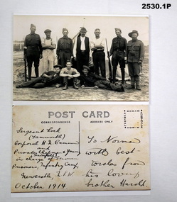
Postcard - POSTCARDS WW1, c.1914
.1) H.N.Cummin. Harold Nesbit Cummin had prior Military service (unclear) to joining the AIF. No 1239 he enlisted on 17.8.1915 in the 6th reinforcements to the 11th Light Horse Regt age 20 years. Embark for Egypt 27.10.1915, hospital 3.1.1916 with Bronvhitis, rejoin unit 15.1.1916, over some 7 months from 4.4.1916 he transfers 4 times until 2.11.1916 and listed as 4th Australian Camel Regt, by 16.2.1917 he is classed as being with 11th Coy 3rd Anzac Batt 1st Camel Brigade, WIA 1.12.1917 GSW’s, DOW’s at 2nd L.H.Brigade Field Ambulance 1.12.1917 in Jaffa. Refer 2535P re his brother Alexander Norman. The photo obviously refers to his previous service as the photo is dated “Oct 1914”. The Germans are possibly people interned after outbreak of the war. .1) Photo of 4 armed Australian Soldiers with 6 civilians, verso postcard has hand written description. .2) Generic postcard from Egypt to a brother, verso letter from Harold to Norman. .3) Photo of 2 WWI German Servicemen with no headgear, verso addressed to a German lady - see Inscriptions & Markings. .1) SGT LOCK (Tamworth), CPL H N CUMMIN & PTES CHAPMAN & YOUNG (Tenterfield) in charge of German prisoners, Infantry Camp, Newcastle, NSW, October 1914. Address: To Norman with best wishes from his loving brother Harold. .2) Dated 5.10.1917 Dear Norman, .... 17 lines .... Your loving brother Harold. .3) To Frau A Muxfeldt Niendorf (Kr Tinneberg) Gaustedterueg No 19, Gesebrieben d 18 Juli 1918. Absender Hugu Muxfeldt No 252 15 Prisoner of War Coy France C/o GPO London Englandpostcards, photographs, 38th -
 Bendigo Military Museum
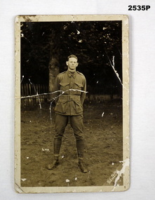
Postcard, c.1916
Alexander Norman Cummin (Sandy) No 18 enlisted in the AIF in the 38th Batt HQ on 22.2.1916 age 19 years 4 months. Embark for England 20.6.1916, embark for France 22.11.1916, WIA 11.8.1918 Shell wounds (unclear), rejoin unit 23.9.1918, hospital while on leave 1.12.1918 with Bronchitis, return too Australia 24.12.1918 with Influenza, discharged from the AIF 21.3.1919 medically unfit.Portrait black & white of soldier standing. Australian soldier has no head dress, name Sandy. ALEXANDER NORMAN CUMMIN.On photo itself is a small number 4072. The bottom RHS has T L FULLER AMESBURY. The rear: Larkhill Camp Amesbury Salisbury Plain England. To Mr Harvey with love and best wishes Sandy 29.8.16. Sailed June 20/16documents - postcards, photography-photographs, military history - army -
 Bendigo Military Museum
Postcard, c.1916
Item in the collection relating to Alexander Norman Cummin No 18, 38th Batt AIF. Refer 2535P for his service details.Black & white photo of large number of Australian Soldiers, 4 rows seated & standing. There is a large galvanised shed behind them. Front: Has a fine engraved number, E.8234 Rear: B Coy No 5 Platoon - B Coy 38th taken Larkhill 1916 Englandphotography-photographs, documents - postcards, military history - army -
 Bendigo Military Museum
Photograph - PHOTOGRAPHS WW1, c. 1915 - 1919
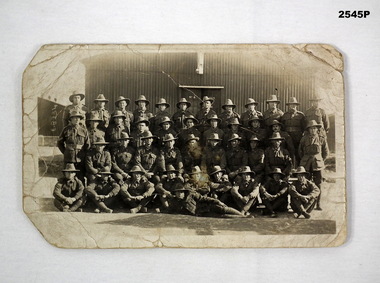
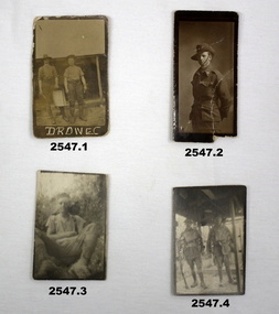
Items relating to the collection re Alexander Norman Cummin No 18, 38th Batt AIF, his brother Harold Nesbit Cummin No 1239 Camel Corp. Refer 2535P (Alexander) 2530.3P (Harold) for their service details. .6) Graves photo. On the left, Sydney Graham Issell. He had 4 years pre war service in Senior cadets and Citizens Forces reaching the rank of Sgt. Enlisted on 8.2.1916 No 912 with the rank of Cpl, C Coy 38th Batt age 21 years 11 months. Embark for England 20.6.1916, promoted L/Sgt, embark for France 22.11.1916, hospital 13.5.1917 (NYD) rejoin unit 19.5.1917, WIA 29.5.1917 GSW chest then restated GSW Back, severe, rejoin unit 12.3.1918, KIA 1.8.1918. On the right, Harold James Fraser. He had 5 years pre war service in the Cadets and Citizens Forces. Enlisted on 27.10.1916 No 2802 6th reinforcements 38th Batt age 22 years. Embark for England 16.12.1916, moves through 10th, 14th Training Batt’s then 66th Batt on 28.4.1917, promoted Sgt and alloted No 2802A, embark for France 25.8.1917 as reinforcement 38th Batt, awarded the Military medal (MM)) 12.10.1917 East of Eypres, KIA 1.8.1918. Both were buried at Vaire Wood near Corbie. .1) 2 Australian soldiers in fatigues with what looks like a cooking apparatus, with letters below DROW EC (stylised). .2) 1/2 length portrait of an Australian soldier. .3) Casual portrait of a soldier sitting in fatigues, probably Sandy. Boots look muddy, scrub in background. .4) Portrait of 2 soldiers (allied) fully armed & wearing helmets. .5) Portrait of a soldier (allied) fully armed & dangerous. .6) Black & white photo of 2 graves with white crosses. Soldiers left cross: No 912 SGT SG ISSELL 38 BN AIF, Soldier right cross: No 2802 SGT HJ FRASER 38 BN AIF. .7) Black & white photo showing 2 Australian soldiers casually dressed in the ruins of an old factory. .8) Black & white mini photo showing building ruins & what appears to be derelict boilers. .9) Black & white mini photo showing what appears to be a WWI German soldier kamerading (surrendering). This is probably posing in captured enemy clothing. 10.) Black & white mini photo showing camels at rest. .11) Black & white mini photo showing a blown up British pattern tank MK1 on sandy terrain. A track has detached & curled up over the front of the tank. .1) verso: “Me & Sandy Port De Nieppe May 1917” .2) verso: “Taken in Liverpool, England while on <> leave Jan 1918. To Mother Father & all at home with love from Sandy”photography-photographs, military history - army, 38th -
 Surrey Hills Historical Society Collection
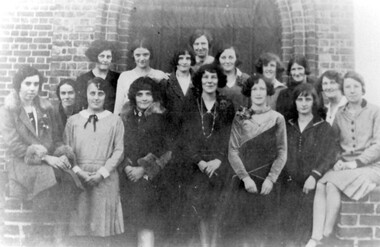
Photograph, Holy Trinity Kindergarten Sunday School teachers, 1920s
Miss Patience Cornell, the leader of the group, is in the centre. Training classes were held for leaders at St Pauls Cathedral and St Johns, concluding with examinations. They then trained their assistants. Holy Trinity was known for implementing new ideas and programs for their 70 children. Far right is Miss Joy Dicker, who was leader from 1930 for 30 years. Identified as: Back LtoR: Doris Wiles, Doris Hearne, Beryl Hearne, …, Mary Chipperfield, Lal Clark, … Centre: Patience Cornell Front: … Wilson, Jessie Collins, Muriel Chipperfield, Una Blakie, Marj Andrews, Myra Lock, Joy Dicker Patience Cornell was the daughter of Frank and Blanche Cornell. Frank Cornell was first listed in Surrey Hills in 1906 at (6) Lorne Parade. In 1908 the listing gives his occupation as a clerk. He was born in 1869 in Richmond, Victoria and died 15 April 1917 in Surrey Hills from a stroke. His wife Blanche Annie Parsons Cornell (nee Bracher) was born in 1869 in Hokitika, New Zealand; she died on 21 January 1940. Children were: Gilbert Frank Cornell (b1894, Hawthorn; d1908, at Frankston beach, an accidental drowning) Ruth Amelia Cornell (b 1899, Kew; d 29 May 1977, Kew) Lorna Amy Cornell (b 1906, Surrey Hills; d unknown) Patience Blanche Cornell (b1907, Surrey Hills; d unknown). Ruth Amelia married David Ellis, c1922 in Surrey Hills. David was a dentist who practised in Surrey Hills for many years. Patience (Pat) Blanche married Norman Henry Brewer (1893–1975) in 1931 in Surrey Hills. A black and white photograph of sixteen girls standing in the doorway of a church.(miss) patience cornell, (miss) joy dicker, (ms) doris wiles, (ms) doris hearne, (ms) beryl hearne, (ms) mary chipperfield, (ms) lal clark, (ms) -, wilson, (ms) jessie collins, (ms) muriel chipperfield, (ms) una blakie, (ms) myra lock, holy trinity church of england, kindergarten teachers, clothing and dress, 1920-1929, (ms) marj andrews -
 Surrey Hills Historical Society Collection
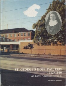
Book, St George's Hospital Kew; an early Anglican hospital, 1981
St. George's Hospital, Kew was founded in 1912 by the Church of England. In 1925 a maternity wing was added and the hospital was registered as a Midwifery Training School. After WWII the Church of England decided to sell it. The book deals with its development up until 1980.St. George's Hospital, Kew was founded in 1912 by the Church of England. In 1925 a maternity wing was added and the hospital was registered as a Midwifery Training School. After WWII the Church of England decided to sell it. The book deals with its development up until 1980.st. george's hospital, kew, 1912, hospitals, medical services, nurses, health establishments, ellerslie, church of england, midwifery training school, world war, 1939-1945, health professionals -
 Kew Historical Society Inc
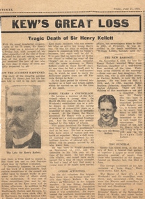
Newspaper - Newspaper Article, Kew's Great Loss, 27/06/1924
Sir Henry de Castres Kellett (1851-1924) the son of a hereditary baronet, was born at Mt Gambier, South Australia in 1851. His English title had been created in Ireland in 1801, but the family was originally Norman with the later branches living in England and Ireland. Sir Henry Kellett assumed the title in 1906. Henry Kellett was a prominent Kew retailer, continuing his father’s newspaper and stationery business in Bulleen Road (now High Street). At various stages, he also acted as an insurance, postal and real estate agent. He lived in Walpole Street and later at Lota Begg (now demolished) in Westbrook Street, East Kew. In 1884, Henry Kellett was elected to the Kew Borough Council and served for 40 years; a remarkable example of public service. He was elected Mayor for a single term in 1888-9. Sir Henry de Castres Kellett died in St George’s Hospital in 1924 following a tragic car accident in Cotham Road, Kew while on Council business. The vehicle, in which he was travelling with fellow councillors and the Town Clerk, collided with a tram. Sir Henry Kellett is commemorated in the naming of Kellett Reserve and Kellett Grove.Newspaper report in The Sentinel reporting the death of Cr Sir Henry Kellett in 1924mayors of kew (vic), sir henry de castres kellett -
 Kew Historical Society Inc
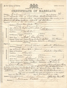
Certificate - Certificate of Marriage, Henry de Castres Kellett & Joan Harrison, 1880, 09/11/1880
Sir Henry de Castres Kellett (1851-1924) the son of a hereditary baronet, was born at Mt Gambier, South Australia in 1851. His English title had been created in Ireland in 1801, but the family was originally Norman with the later branches living in England and Ireland. Sir Henry Kellett assumed the title in 1906. Henry Kellett was a prominent Kew retailer, continuing his father’s newspaper and stationery business in Bulleen Road (now High Street). At various stages, he also acted as an insurance, postal and real estate agent. He lived in Walpole Street and later at Lota Begg (now demolished) in Westbrook Street, East Kew. In 1884, Henry Kellett was elected to the Kew Borough Council and served for 40 years; a remarkable example of public service. He was elected Mayor for a single term in 1888-9. Sir Henry de Castres Kellett died in St George’s Hospital in 1924 following a tragic car accident in Cotham Road, Kew while on Council business. The vehicle, in which he was travelling with fellow councillors and the Town Clerk, collided with a tram. Sir Henry Kellett is commemorated in the naming of Kellett Reserve and Kellett Grove.Original Marriage Certificate of Henry de Castres Kellet and Joan Harrosn, in Richmond on 9 November 1880mayors of kew (vic), sir henry de castres kellett -
 Kew Historical Society Inc
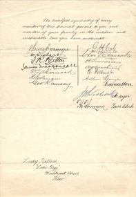
Letter - Letter of Condolence, Lady Kellett, Lota Begg, Westbrook Street, Kew, 1924
Sir Henry de Castres Kellett (1851-1924) the son of a hereditary baronet, was born at Mt Gambier, South Australia in 1851. His English title had been created in Ireland in 1801, but the family was originally Norman with the later branches living in England and Ireland. Sir Henry Kellett assumed the title in 1906. Henry Kellett was a prominent Kew retailer, continuing his father’s newspaper and stationery business in Bulleen Road (now High Street). At various stages, he also acted as an insurance, postal and real estate agent. He lived in Walpole Street and later at Lota Begg (now demolished) in Westbrook Street, East Kew. In 1884, Henry Kellett was elected to the Kew Borough Council and served for 40 years; a remarkable example of public service. He was elected Mayor for a single term in 1888-9. Sir Henry de Castres Kellett died in St George’s Hospital in 1924 following a tragic car accident in Cotham Road, Kew while on Council business. The vehicle, in which he was travelling with fellow councillors and the Town Clerk, collided with a tram. Sir Henry Kellett is commemorated in the naming of Kellett Reserve and Kellett Grove.Original official document from a noted event in Kew's historyOne page undated, handwritten letter of condolence to Lady Kellett on her husband's accidental death in 1924 while serving as a Kew Councillor. The latter is signed by his fellow councillors, the Mayor and the Town Clerkmayors of kew (vic), sir henry de castres kellett -
 Kew Historical Society Inc
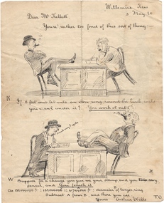
Drawing - Visual Vignettes, Sir Henry de Castres Kellett & Arthur Wills / by Arthur Wills, 1920
Sir Henry de Castres Kellett (1851-1924) the son of a hereditary baronet, was born at Mt Gambier, South Australia in 1851. His English title had been created in Ireland in 1801, but the family was originally Norman with the later branches living in England and Ireland. Sir Henry Kellett assumed the title in 1906. Henry Kellett was a prominent Kew retailer, continuing his father’s newspaper and stationery business in Bulleen Road (now High Street). At various stages, he also acted as an insurance, postal and real estate agent. He lived in Walpole Street and later at Lota Begg (now demolished) in Westbrook Street, East Kew. In 1884, Henry Kellett was elected to the Kew Borough Council and served for 40 years; a remarkable example of public service. He was elected Mayor for a single term in 1888-9. Sir Henry de Castres Kellett died in St George’s Hospital in 1924 following a tragic car accident in Cotham Road, Kew while on Council business. The vehicle, in which he was travelling with fellow councillors and the Town Clerk, collided with a tram. Sir Henry Kellett is commemorated in the naming of Kellett Reserve and Kellett Grove.Original artwork by Arthur Wills, descendent of a noted pioneer family, and former mayor of Kew.Two sided illustrated humorous vignettes featuring two noted Kew citizens: Henry de Castres Kellet and Arthur Wills. The latter is the illustrator. The item was illustrated in 1920.mayors of kew (vic), sir henry de castres kellett, arthur wills, willsmere, wills family