Showing 40 items matching "parish of port melbourne"
-
 City of Moorabbin Historical Society (Operating the Box Cottage Museum)
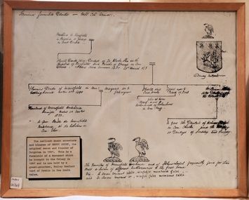
Document - Genealogy Chart Henry Dendy (Photocopy), 19 thC
... dendy henry, dendy's special survey brighton 1841, governor gipps, captain lonsdale, super-intendant latrobe, port phillip, melbourne, new south wales, squatters, emmigrants, county of bourke, parish of moorabbin, early settlers, pioneers, market gardeners, dairy farmers, fruit farms, moorabbin, bentleigh, brighton, cheltenham, were jonathan binn,...Melbourne. In 1840 Henry Dendy, a farmer in Surrey, England acquired a "Special Survey" from the Commissioners for Land and Emigration which gave Dendy the right to choose land in Port Phillip for the price of only £1 per acre for 5120 acres. This land was called Brighton in the Parish ...In 1840 Henry Dendy, a farmer in Surrey, England acquired a "Special Survey" from the Commissioners for Land and Emigration which gave Dendy the right to choose land in Port Phillip for the "bargain basement" price of only £1 per acre for 5120 acres, (an area of 8 square miles). The Special Survey also included the right to "the shipment of a worker for every £20 spent on land, whose free passage was paid by the Crown, equalling a total of 100 workers ". Accordingly Dendy sold his English holdings and paid the required £5120 and arrived in Melbourne in February 1841. However by this time land in the new colony was selling for £5 - £40 per acre. Because Henry Dendy possessed the order from the Colonial Office in London he was able to successfully oppose Super-intendant LaTrobe's attempts to alter the price of the land. Dendy appointed Jonathan Were, (an entrepreneur, who had arrived in 1839), as his Manager and who later became a partner. Together, Dendy and Were decided on an area 5 miles south from Melbourne, bounded by North Road, East Boundary Road, South Road and to the west by Port Phillip Bay. Were and Dendy pitched their tents in the area now known as ' Park St, Brighton' and sank a well near the corner of 'St Andrew's St and Wells St'. By 1845 J.B Were and Company had bought almost half of Dendy's land and Were built himself "Moorabbin House" in Were St Brighton made from stone, quarried from local cliffs. It was still standing in 1924. Legend records Moorabbin is named after the Aboriginal word for ' Mother's Milk ' The soil is very fertile and well supplied with water especially in the area called 'East Brighton' - now known as Bentleigh and East Bentleigh - By 1850 the area had developed with numerous market gardens, dairy farms, fruit gardens and vineyards supplying food for the growing population of Melbourne.In 1840 Henry Dendy, a farmer in Surrey, England acquired a "Special Survey" from the Commissioners for Land and Emigration which gave Dendy the right to choose land in Port Phillip for the price of only £1 per acre for 5120 acres. This land was called Brighton in the Parish of Moorabbin, County of Bourke and emigrants developed the land establishing market gardens , dairy and poultry farms that provided the food for the growing population of Melbourne. A photocopy of the Genealogy Chart of the Dendy Family that Henry Dendy brought with him when he emigrated to Melbourne 1841Genealogy signs and descriptionsdendy henry, dendy's special survey brighton 1841, governor gipps, captain lonsdale, super-intendant latrobe, port phillip, melbourne, new south wales, squatters, emmigrants, county of bourke, parish of moorabbin, early settlers, pioneers, market gardeners, dairy farmers, fruit farms, moorabbin, bentleigh, brighton, cheltenham, were jonathan binn, -
 City of Moorabbin Historical Society (Operating the Box Cottage Museum)
Document, Henry Dendy family Shield
... dendy henry, dendy's special survey brighton 1841, governor gipps, captain lonsdale, super-intendant latrobe, port phillip, melbourne, new south wales, squatters, emmigrants, county of bourke, parish of moorabbin, early settlers, pioneers, market gardeners, dairy farmers, fruit farms, moorabbin, bentleigh, brighton, cheltenham, were jonathan binn,...Legend records Moorabbin is named after the Aboriginal word for ' Mother's Milk ' The soil is very fertile and well supplied with water especially in the area called 'East Brighton' - now known as Bentleigh and East Bentleigh - By 1850 the area had developed with numerous market gardens, dairy farms, fruit gardens and vineyards supplying food for the growing population of Melbourne. dendy henry, dendy's special survey brighton 1841, governor gipps, captain lonsdale, super-intendant latrobe, port phillip, melbourne, new south wales, squatters, emmigrants, county of bourke, parish of moorabbin, early settlers, pioneers, market gardeners, dairy farmers, fruit farms, moorabbin, bentleigh, brighton, cheltenham, were jonathan binn, Document, Henry Dendy family Shield ...In 1840 Henry Dendy, a farmer in Surrey, England acquired a "Special Survey" from the Commissioners for Land and Emigration which gave Dendy the right to choose land in Port Phillip for the "bargain basement" price of only £1 per acre for 5120 acres, (an area of 8 square miles). The Special Survey also included the right to "the shipment of a worker for every £20 spent on land, whose free passage was paid by the Crown, equalling a total of 100 workers ". Accordingly Dendy sold his English holdings and paid the required £5120 and arrived in Melbourne in February 1841. However by this time land in the new colony was selling for £5 - £40 per acre. Because Henry Dendy possessed the order from the Colonial Office in London he was able to successfully oppose Super-intendant LaTrobe's attempts to alter the price of the land. Dendy appointed Jonathan Were, (an entrepreneur, who had arrived in 1839), as his Manager and who later became a partner. Together, Dendy and Were decided on an area 5 miles south from Melbourne, bounded by North Road, East Boundary Road, South Road and to the west by Port Phillip Bay. Were and Dendy pitched their tents in the area now known as ' Park St, Brighton' and sank a well near the corner of 'St Andrew's St and Wells St'. By 1845 J.B Were and Company had bought almost half of Dendy's land and Were built himself "Moorabbin House" in Were St Brighton made from stone, quarried from local cliffs. It was still standing in 1924. Legend records Moorabbin is named after the Aboriginal word for ' Mother's Milk ' The soil is very fertile and well supplied with water especially in the area called 'East Brighton' - now known as Bentleigh and East Bentleigh - By 1850 the area had developed with numerous market gardens, dairy farms, fruit gardens and vineyards supplying food for the growing population of Melbourne. dendy henry, dendy's special survey brighton 1841, governor gipps, captain lonsdale, super-intendant latrobe, port phillip, melbourne, new south wales, squatters, emmigrants, county of bourke, parish of moorabbin, early settlers, pioneers, market gardeners, dairy farmers, fruit farms, moorabbin, bentleigh, brighton, cheltenham, were jonathan binn, -
 City of Moorabbin Historical Society (Operating the Box Cottage Museum)
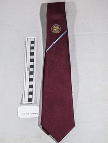
Clothing - Clothing, City of Moorabbin Tie, Circa 1960s
... City of Moorabbin Historical Society (Operating the Box Cottage Museum) Joyce Park Jasper Road Ormond melbourne The City of Moorabbin existed from 1934 until 1994. Henry Dendy's Special Survey in 1841 of 5,120 acres in the Parish of Moorabbin , extended from Port Phillip Bay , then East to Boundary Road, South to South Road and North to North Road and became known as Brighton. 1859 Brighton became a Borough with its boundary Thomas Street ,and Bluff Road. ...The City of Moorabbin existed from 1934 until 1994. Henry Dendy's Special Survey in 1841 of 5,120 acres in the Parish of Moorabbin , extended from Port Phillip Bay , then East to Boundary Road, South to South Road and North to North Road and became known as Brighton. 1859 Brighton became a Borough with its boundary Thomas Street ,and Bluff Road. In 1862 The Moorabbin Roads Board was formed and the extended area now included Cheltenham, Hampton, Sandringham, Black Rock, Beaumaris, Mentone and Mordialloc .and Little Brighton became known as Bentleigh. In 1871 the area became known as The Shire of Moorabbin. Gradually the area was separated into The Borough of Sandringham 1917, ( Black Rock, Beaumaris , Sandringham and Hampton ) Borough of Mentone and Mordialloc 1920, ( Parkdale ). In 1934 The City of Moorabbin was established for the area from South East corner of Thomas Street and North Road , East to Warrigal Road, Clayton Road, Kingston Road , Lower Dandenong Road, then South along Nepean Highway to Balcombe Road and along Bluff Road, Cummins Road, Nepean Highway, Thomas Street to North Road In the 1994 Amalgamation of Councils the City of Moorabbin was divided between the new City of Kingston in the South ( from South Road) and the new City of Glen Eira to the North . It was the largest Municipality in Victoria with a population of 118,865 in 1974This tie c 1960 is a memento of the City of Moorabbin 1934 - 1994Maroon colour, polyester, man's tie with the crest of City of Moorabbin woven on front.around circle enclosing Coat of Arms ; CITY OF MOORABBIN city of moorabbin, moorabbin roads board, moorabbin, brighton, dendy's special survey 1841, early settlers, pioneers, market gardners, dendy henry, were jonathan b, cheltenham, bentleigh, mentone, sandringham, mair william, bent thomas -
 Port Melbourne Historical & Preservation Society
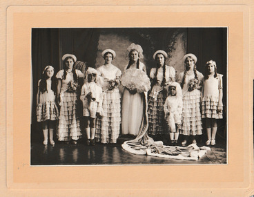
Photograph - Coronation of the Holy Trinity Carnival Queen 1931, 28 November 1931
... The purpose of the annual Port Melbourne Holy Trinity Church Queen and King competition was to raise Parish funds. ...The purpose of the annual Port Melbourne Holy Trinity Church Queen and King competition was to raise Parish funds. ...The purpose of the annual Port Melbourne Holy Trinity Church Queen and King competition was to raise Parish funds. The ceremony held on Saturday 28th November 1931 was to Crown Miss Dulcie SMITH as the Carnival queen. As Queen of the Sunday School, she gained the most votes. On the church tower each day leading to the crowning a coloured flag was flown representing the group which was currently leading in the voting. the flying of the orange flag announced Dulcie's win. Back row from L to R - Valda SMITH, Keitha (Treasure) ALLISON, -?- , Dulcie SMITH, -?- , -?- , Edith DURSTAN. Front row from L to R - Albert SMITH, Bill RACHINGER.Mounted on yellow card, the sepia photograph shows seven female figures in long dresses and hats. The central figure holding a large fan wears an elaborate headdress and has a long train. In front are two young boys in fancy dress.religion - anglican (holy trinity), port melbourne holy trinity church king & queen carnival, celebrations fetes and exhibitions, dulcie smith, valda smith, keitha (treasure) allison, albert smith, edith durstan, bill rachinger -
 Bayside Gallery - Bayside City Council Art & Heritage Collection
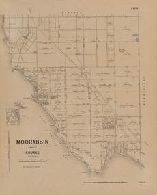
Map, Department of Crown Lands and Survey, Moorabbin, County of Bourke, c. 1918
... melbourne The cadastral map of the Parish of Moorabbin in Victoria (L.6104) shows parish boundaries and land ownership c. 1918 when Sandringham was a Borough. Moorabbin County of Bourke Map Plan land subdivision land titles Foreshores Sndringham Hampton Beaumaris Highett Cheltenham Department of Lands and Survey Land owners cartographic material Borough of Sandringham Brighton Photolithograph. Printed in black ink on cream paper, the map shows street names, subdivision of blocks, sizes of the blocks and the names of the landowners. Port ...The cadastral map of the Parish of Moorabbin in Victoria (L.6104) shows parish boundaries and land ownership c. 1918 when Sandringham was a Borough.moorabbin, county of bourke, map, plan, land subdivision, land titles, foreshores, sndringham, hampton, beaumaris, highett, cheltenham, department of lands and survey, land owners, cartographic material, borough of sandringham, brighton -
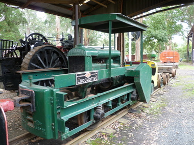 Puffing Billy Railway
TACL - Erica State Sawmill Rail Tractor, 1928
... TACL-Tractor Appliance Company Limited TACL rail tractors manufactured by Malcolm Moore of Port Melbourne Located in the Parishes of Moondarra and Telbit, Gippsland, the tramway terminated at Collins Siding on the Moe Walhalla 2'6"gauge branch of the Victorian Railways. ...Puffing Billy Railway 1 old monbulk road Belgrave yarra-valley-and-the-dandenong-ranges TACL-Tractor Appliance Company Limited TACL rail tractors manufactured by Malcolm Moore of Port Melbourne Located in the Parishes of Moondarra and Telbit, Gippsland, the tramway terminated at Collins Siding on the Moe Walhalla 2'6"gauge branch of the Victorian Railways. ...TACL-Tractor Appliance Company Limited TACL rail tractors manufactured by Malcolm Moore of Port Melbourne Located in the Parishes of Moondarra and Telbit, Gippsland, the tramway terminated at Collins Siding on the Moe Walhalla 2'6"gauge branch of the Victorian Railways. Its construction by the Forests Commission of Victoria was to facilitate the extraction of timber from the Southern and Western slopes of Mount Erica and to replace the outlet tramways destroyed during the disastrous forest fires of February 1926. Tyers Valley Tramway The line, following the Eastern arm of the river, passed Ingrams Siding (7m.) to terminate at a forest area, known as "Ten Acre Block", 8m. 60c. from Collins Siding. The western branch of the line followed the Western Tyers Valley to Growlers Creek, 13m. 40c. from Collins Siding. THE T.A.C.L. TRACTORS at Tyers Valley tramway. On the 19th January 1928, T.A.C.L. locomotive, purchased from Tractor Appliance Co. Ltd. (Malcolm Moore), was delivered. This unit had a 20 h.p. Fordson engine coupled by a chain drive to the two axles, providing a tractive effort of approx. 2000lbs. Wheelbase was 5’ and weight was four tons. It was intended that the two tractor locomotives, working with the grade, would deliver timber from the branch lines to Tyers Junction, from which place it would be steam hauled out to the Collins Siding transfer point. Following a breakdown of the steam locomotive, haulage during the early months of 1928 was carried out by the T.A.C.L. unit, supplemented by the Nattrass, which was, by this time, becoming unreliable. During April 1928, after ensuring that no suitable locomotive was available in Australia, an order was placed with the Climax Manufacturing Co., U.S.A. for the supply of a geared locomotive. A second T.A.C.L. engine was purchased during May and, on the 27th, the local mill owners, having obtained running rights on the tramway, commenced haulage with the Harman. The three tractor units worked the branch lines and transported ballast, whilst the Harman hauled the timber to Collins Siding in rakes of eight trucks (56 tons). The weekly loading of the line for the first, second and third weeks were 54, 62 and 71 trucks respectively. info from : http://www.nmra.org.au/tyersvalley/Tyers-Tram.html Historic - Industrial Narrow gauge Railway - Timber working - Rail Tractor used by the the Forests Commission of Victoria on the Tyers Valley TramwayRail Tractor with Fordson engine coupled by a chain drive to the two axles - made of steel and wrought ironerica sawmill, puffing billy, tacl, rail tractor, tractor appliance co. ltd. (malcolm moore), industrial narrow gauge railway, tyers valley tramway, forests commission of victoria -
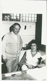 Uniting Church Archives - Synod of Victoria
Photograph, Ron Croxford & Peter Mulheisen, 09/1986
... Ron Croxford had been ordained in 1966, and parishes included Yirrakala (1961-64), Caulfield (1967-68), Mt Waverley (1969-74), Sth & Port Melbourne Mission (1975-77), South-Port-Parks 1977-?...Uniting Church Archives - Synod of Victoria 54 Serrell Street Malvern East melbourne The photo was part of the September 24 1986 edition of C&N as the 'cover story', entitled "House of fallen angels", and the article was about Moreland Hall (in 2015 renamed as ReGen) and its work with alcohol and other drug addictions. Croxford was the executive director and Mulheisen the pharmacist at Moreland Hall. The Rev. Ron Croxford had been ordained in 1966, and parishes included Yirrakala (1961-64), Caulfield (1967-68), Mt Waverley (1969-74), Sth & Port ...The photo was part of the September 24 1986 edition of C&N as the 'cover story', entitled "House of fallen angels", and the article was about Moreland Hall (in 2015 renamed as ReGen) and its work with alcohol and other drug addictions. Croxford was the executive director and Mulheisen the pharmacist at Moreland Hall. The Rev. Ron Croxford had been ordained in 1966, and parishes included Yirrakala (1961-64), Caulfield (1967-68), Mt Waverley (1969-74), Sth & Port Melbourne Mission (1975-77), South-Port-Parks 1977-?Ron Croxford is shown standing by a seated Peter Mulheisen.Their names.croxford, ron, mulheisen, peter, moreland hall (regen) -
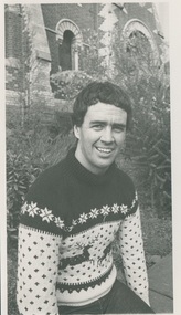 Uniting Church Archives - Synod of Victoria
Photograph, Cliff Barclay, 1988
... Port-Parks parish mission. The church in the background of this photograph is the South-Port-Parks church, Dorcas Street, South Melbourne....Uniting Church Archives - Synod of Victoria 54 Serrell Street Malvern East melbourne Cliff Barclay was a youth worker at the South-Port-Parks parish mission. ...Cliff Barclay was a youth worker at the South-Port-Parks parish mission. The church in the background of this photograph is the South-Port-Parks church, Dorcas Street, South Melbourne.B & W waist length photograph of Cliff Barclay, with a bluestone church in the background.Cliff Barclay, youth worker at South-Port-Parks.cliff barclay, south-port-parks parish mission -
Whitehorse Historical Society Inc.
Newspaper - Article, Blood's Cottage, Box Hill, 2/12/1992
... Whitehorse Historical Society Inc. 2-10 Deep Creek Road Mitcham melbourne Bloods Cottage Box Hill Blood Robert Oxford Childrens Theatre Mudge Joy Port Ian Blood's Cottage [ the oldest surviving house in the Parish of Nunawading] recently used by Oxford Childrens Theatre. ...Blood's Cottage [ the oldest surviving house in the Parish of Nunawading] recently used by Oxford Childrens Theatre.bloods cottage, box hill, blood, robert, oxford childrens theatre, mudge, joy, port, ian -
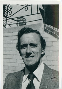 Uniting Church Archives - Synod of Victoria
BW photo, Undated
... Parishes: Cobram 1952, Wedderburn 1953, Foster 1956, Foster-Torra 1957–59, Womboota-Mathoura 1960–61, Port Melbourne 1962, Albert Park 1963–66, Cohuna 1967–70, Bendigo West 1971–78, Albury 1979–02/85, Black Rock 03/85. ...Parishes: Cobram 1952, Wedderburn 1953, Foster 1956, Foster-Torra 1957–59, Womboota-Mathoura 1960–61, Port Melbourne 1962, Albert Park 1963–66, Cohuna 1967–70, Bendigo West 1971–78, Albury 1979–02/85, Black Rock 03/85. ...Ordained 1961. Parishes: Cobram 1952, Wedderburn 1953, Foster 1956, Foster-Torra 1957–59, Womboota-Mathoura 1960–61, Port Melbourne 1962, Albert Park 1963–66, Cohuna 1967–70, Bendigo West 1971–78, Albury 1979–02/85, Black Rock 03/85. Retired 1996. One time Chairperson of Loddon-Campaspe Presbytery.Rev. John (Jock) McOrist: Head & shoulders portrait, standing adjacent to some steps. Wearing coat and tie.J McOrist, Chairman Loddon Campaspe Presbytery. Church and Nation 24 May ? p8rev. john (jock) mcorist; cobram, wedderburn, foster, melbourne, albert park, bendigo west, albury, black rock; retired 1996