Showing 1023 items matching "planning department"
-
 University of Melbourne, Burnley Campus Archives
Plan - Coloured plan, Plan of Burnley Gardens, 1929?
... Part of larger plan (Lands Department Parish Plan). Partly... of larger plan (Lands Department Parish Plan). Partly hand-drawn ...Layout of gardens, farm buildings, orchard, etc. overlaid on part of Lands Department map. See paper catalogue for full descriptionPart of larger plan (Lands Department Parish Plan). Partly hand-drawn. Area bounded by Yarra River, Swan St, Glen Iris railway line. Shows Burnley Gardens layout, handwritten amendments and explanation of existing and proposed structures including: Pavilion, sketch of unbuilt Administrative Building, poultry yard, contours of old orchard, sketch for Plant Research Institute, ditch, silo, milking shed, laying pens. See aboveburnley gardens, pavilion, burnley school of horticulture, farm buildings, poultry -
 Eltham District Historical Society Inc
Document - Property Binder, 736 Main Road, Eltham
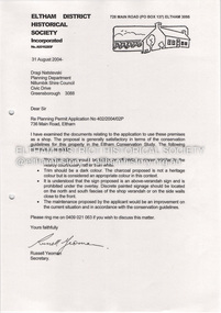
... to Dragi Natstevski Planning Department Nillumbik Shire Council... to Dragi Natstevski Planning Department Nillumbik Shire Council ...Letter 31 August 2004 Eltham District Historical Society to Dragi Natstevski Planning Department Nillumbik Shire Council commenting on Planning Permit Application No 402/2004/02P, Part Shire of Eltham Heritage Study, pages 1440-1243, re brick shop and side dwelling 738 Main Road. Entry in Victorian Heritage Database for 738 Main Road Eltham. Newspaper article: Beacons of light, Marguerite Marshall; Copperline Inaugural Edition, October 2022 Newspaper article: Beacons of light update, Marguerite Marshall; Copperline Edition 7, July 2023main road, eltham, property, houses, shops, zen den cafe, 736 main road eltham -
Glenelg Shire Council Cultural Collection
Letter - Letter - Ray Tonkin to Vanda Savill, 28/10/1992
... Buildings Council, Department of Planning and Housing...., Historic Buildings Council, Department of Planning and Housing ...Letter to vanda Savill, from Ray Tonkin, director, Historic Buildings Council, Department of Planning and Housing.vanda savill, heywood, historic building -
 Eltham District Historical Society Inc
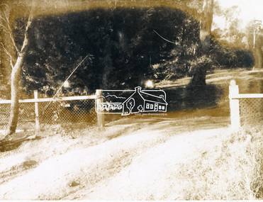
Photograph, 19 Rockcliffe Street (Brougham Street entrance), Eltham, 3:30pm, 5 July 1967, 1967
... Brougham Street Photo taken by Russell Yeoman, Planning Department... Brougham Street Photo taken by Russell Yeoman, Planning Department ...Lot 6 L.P. 9499 at eastern most end of Brougham Street Property has since been subdivided and this access end is now 146 Brougham Street Photo taken by Russell Yeoman, Planning Department, Shire of Eltham In the 1954 Electoral Roll Ella Dunkel was listed as living in Diamond Street, Home Duties. In the 1963/1967/1968/1972/1977 electoral rolls she was listed at 19 Rockcliffe Road, Home Duties. Probate was granted 18 July 1979 (Wills and Probate Records. VPRS 28 (Probates) and VPRS 7591 (Wills). Public Record Office Victoria, North Melbourne, Victoria.)Polaroid photographPolaroid Manufacturer Code K603831 #7brougham steet, houses, rockcliffe street, eltham, ella dunkel -
 Eltham District Historical Society Inc
Photograph, 19 Rockcliffe Street (Brougham Street entrance), Eltham, 3:30pm, 5 July 1967, 1967
... Brougham Street Photo taken by Russell Yeoman, Planning Department... Brougham Street Photo taken by Russell Yeoman, Planning Department ...Lot 6 L.P. 9499 at eastern most end of Brougham Street Property has since been subdivided and this access end is now 146 Brougham Street Photo taken by Russell Yeoman, Planning Department, Shire of Eltham In the 1954 Electoral Roll Ella Dunkel was listed as living in Diamond Street, Home Duties. In the 1963/1967/1968/1972/1977 electoral rolls she was listed at 19 Rockcliffe Road, Home Duties. Probate was granted 18 July 1979 (Wills and Probate Records. VPRS 28 (Probates) and VPRS 7591 (Wills). Public Record Office Victoria, North Melbourne, Victoria.) 35mm colour positive transparency blue Agfacolour Service plastic mountSlide is marked 19 July 1967 but identical to Polaroid taken by Russell Yeoman at 3:30pm on 5 July 1967 Slide also inscribed E-B and Gp PSCbrougham steet, houses, rockcliffe street, eltham, ella dunkel -
 Rutherglen Historical Society
Image, 1970s
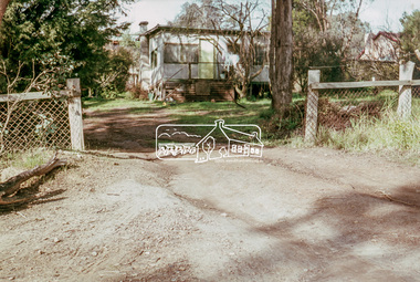
... planning department of Davis. The board had decided it wished... planning department of Davis. The board had decided it wished ...Photo of Harry Tinson who was winemaker at Baileys in Glenrowan from 1968 until 1982. An ageing Alan Bailey (greatgrandson of founder Richard Bailey) sold the winery to Davis Consolidated Industries (mainly a gelatine producer). At the time Harry Tinson, with a Master’s degree in physical engineering, was in the corporate planning department of Davis. The board had decided it wished to diversify into wine production and Tinson was charged with the responsibility of finding a suitable target. He came up with Baileys, and was instructed to negotiate the purchase of a 50 per cent share in the business. Bailey said “all or nothing” ! (James Halliday – news article 22/01/2011)Colour transparency photograph of a man standing in front of a timber panelled wall, featuring an advertising poster for Baileys Bundarra Vineyardswineries, north east victoria, wine industry, baileys, winemaker -
Glenelg Shire Council Cultural Collection
Letter - Letter - Vanda Savill to Frances Hall, n.d
... Hall, Historic Buildings Council, Department of Planning... to Frances Hall, Historic Buildings Council, Department of Planning ...Two photocopies of a letter from Vanda Savill to Frances Hall, Historic Buildings Council, Department of Planning and Housing.historic buildings, heywood, vanda savill -
 Whitehorse Historical Society Inc.
Map - Nunawading scaled Map, Nunawading, 1864
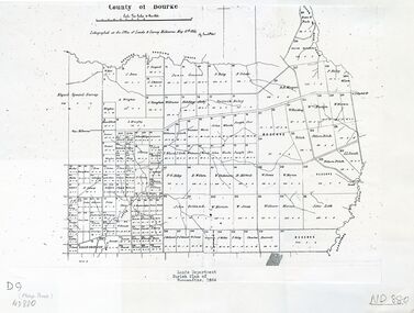
... Parish plan of Nunawading, Lands Department, 1864, showing... plan of Nunawading, Lands Department, 1864, showing names ...Parish plan of Nunawading, Lands Department, 1864, showing names of first purchasers of land. Copy also at NP215.parish of nunawading, land settlement, maps -
University of Melbourne, Burnley Campus Archives
Plan, Alton-Hascombe Feature Survey, c. 1990
... 1 tracing paper and 2 paper copies of plan by Department... tracing paper and 2 paper copies of plan by Department ...1 tracing paper and 2 paper copies of plan by Department of Conservation, Forests and Lands, Division of Survey and Mapping, of adjoining gardens Alton and Hascombe at Mount Macedon, Victoria. Scale 1:1000. Plan of properties includes buildings, gardens and paddocks. 1 copy has significant buildings coloured.feature survey, mount macedon, gardens, alton, hascombe -
Whitehorse Historical Society Inc.
Document, Suggestions for Light Protection of Victoria's Heritage, 1/07/1993
... Department of Planning and Development... of Victoria's heritage drafted by the Heritage Branch of the Department... of the Department of Planning and Development in July 1993 Suggestions ...Sixteen suggestions for local government for the protection of Victoria's heritage drafted by the Heritage Branch of the Department of Planning and Development in July 1993local government, heritage branch, department of planning and development -
 Ringwood and District Historical Society
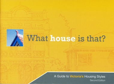
Booklet, What house is that? A Guide to Victoria's Housing Styles
... and it was produced by the Department of Planning and Community Development... was the funder of the project and it was produced by the Department ...The Heritage Council was the funder of the project and it was produced by the Department of Planning and Community DevelopmentYellow covered booklet with photographs and printing of design features with coloured schemes for houses from Early Victorian to Post War Modern. 31 pages forward by Hon. Justin Madden MLC Minister for planning. -
 University of Melbourne, Burnley Campus Archives
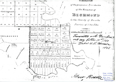
Plan - Photocopy, Sketch of the Proposed Boundaries of the Village of Richmond, 1843
... site as "Reserve. Survey Department." original in Central Plan... site as "Reserve. Survey Department." original in Central Plan ...Sketch of the proposed boundaries of the village of Richmond in the County of Bourke Parish of Jika-Jika. Handwritten on original: "Transmitted with Description and my letter No 43/150 Dated 11th November 1843 Robert Hoddle." Shows Burnley Gardens site as "Reserve. Survey Department." original in Central Plan Office, Department of Natural Resources and EnvironmentIn ink: From Central Plan Office Dept. Nat. Resources & Environmentrichmond, jika-jika, survey department, yarra river, robert hoddle -
 Eltham District Historical Society Inc
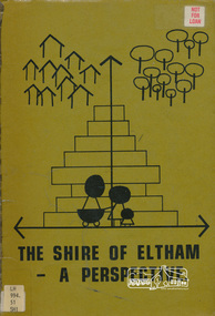
Book, Shire of Eltham, The Shire of Eltham - A Perspective, July 1981
... This report was produced by the Shire of Eltham (Planning... melbourne This report was produced by the Shire of Eltham (Planning ...This report was produced by the Shire of Eltham (Planning Department) following a population study of the Shire. It also includes other areas of general interest. The Document contents includes Present and Future - Population - Housing - Residential Lands - Social Characteristics - Development and History. Includes maps, tables and diagrams. Part 1: The Existing situation - introduction, the Shire of Eltham, physical characteristics, historical development, population growth. Characteristics of the population - size and distribution, age / sex, natural increase, migration. Socio-Economic Factors: socio-economic status, employment/workforce, education, other social factors. Housing/ building statistics: characteristics of Housing stock, current residential trends, other types of building activity. Residential Land: existing vacant lots, estimated additional lots. Part 2: The Future. Land availability, the future population.The Shire of Eltham Council resolved on publication of this report "to commend it to the ratepayers as a most valuable resource document". It provides a comprehensive statistical review of the Shire of Eltham, Victoria in 1981 with some population and development predictions for the future.Spiral bound, soft cover, includes indexBarcode and identification markings including stamped "WITHDRAWN" from Heidelberg Regional Library Serviceshire of eltham, planning, population -
Canterbury History Group
Document - Emulation Hall, Report Recommendation for inclusion in Heritage Register, Built Heritage, 1/12/2011 12:00:00 AM
... Department of Planning and Community Development..., Department of Planning and Community Development on the cultural... Masonic Lodges Symbols Department of Planning and Community ...Built Heritage report to the Victorian Government, Department of Planning and Community Development on the cultural heritage significance of the Emulation Hall. Includes black and white photographscanterbury, emulation hall, rochester road, built heritage, masonic lodges, symbols, department of planning and community development -
 Bacchus Marsh & District Historical Society
Map, Bacchus Marsh Region Parish Plans: Folded set of maps
... Set of Victorian Lands Department Parish Plans covering... Interim Record Set of Victorian Lands Department Parish Plans ...Set of Victorian Lands Department Parish Plans covering the township of Bacchus Marsh and surrounding districts. Folded. BMDHS Location: AR/SU27/D2: Map Drawersmaps bacchus marsh region, bacchus marsh victoria maps, interim record -
Lakes Entrance Historical Society
Book, Victoria Buildings and Builders - Gippsland, 1998
... Architectural drawings by Victorian Public Works Department... Works Department. Lists plans of many public Buildings ...Architectural drawings by Victorian Public Works Department. Lists plans of many public Buildings in Gippsland, and illustrates examples of schools, courthouses and Latrobe Bridge. Contains bibliography.architecture -
 Melbourne's Living Museum of the West
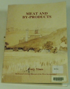
Booklet, Melbourne's Living Museum of the West, Meat and By-Products, 1993
... ", with the assistance of the Department of Planning and Development, Victoria... the Cultural Landscape", with the assistance of the Department ...The meat industry and animal by-product works of Melbourne's West, in the series "Interpreting the Cultural Landscape", with the assistance of the Department of Planning and Development, VictoriaThe Australian Meat Preserving Company was established on the banks of the Maribyrnong River in 1870 on the site of boiling works dating from the 1840s.32 page booklet, A5, Cover illustration of Raleigh's boiling down works on the Maribyrnong River, from water-colour by Greeves C. 1850s Title: Meat and By-Products Author: Gary Vines Melbourne's Living Museum of the West Inc.western suburbs, meat industry -
 Bendigo Historical Society Inc.
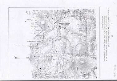
Document - DIAMOND HILL AREA MAP
... Map copy, 2 pages, from 'Old Mines Department Plan, Dept... Department Plan, Dept of Conservation and Environment File No W91006 ...Map copy, 2 pages, from 'Old Mines Department Plan, Dept of Conservation and Environment File No W91006, 16.6.1972' Map shows Golden Gully area with 'Town and Country Hotel' on north side and further south, with shafts and mine names marked.bendigo, mining, diamond hill -
Bialik College
Document (series) - Box of strategic planning booklets and documents
... Improvement Plan 2014, Hebrew Studies Department Strategic Plan 2008... Improvement Plan 2014, Hebrew Studies Department Strategic Plan 2008 ...strategy, elc, religion, 2000s, 1990s, 1980s, 2010s, promotionstrategy, elc, religion, 2000s, 1990s, 1980s, 2010s, promotion -
 Flagstaff Hill Maritime Museum and Village
Document - Plans, Lighthouse Keeper's Quarters Warrnambool, 1858-1909
... , Lighthouse Quarters, Warrnambool, General Plan’ (2375.8)* Department..., Lighthouse Quarters, Warrnambool, General Plan. Department of Public..., Warrnambool, General Plan’ (2375.8)* Department of Public Works ...The set of seven 1858 plans shows proposed plans for the original Lighthouse Complex that was built on Middle Island in 1858-1859. The whole complex was then transferred to Flagstaff Hill in 1871. The plan, dated 1909, is for proposed additions and repairs to the Quarters at Flagstaff Hill. The plan 'Alterations and Additions' shows alternate plans for changes to the quarters at the Flagstaff Hill location. This plan has no date. The Complex comprised the Lighthouse, the Lighthouse Keepers’ Quarters, the Store (now called the Chart Room) and a Privy, which was not included in these plans. The Keeper’s bluestone Quarters was a cottage divided into two compartments, one for each keeper and his family. The bluestone Store was divided into three; a store, a workshop an oil store (or office). The Privy comprised of a small building also divided into two separate, back-to-back toilets, one for each Keeper and his family. The Flagstaff Hill Keeper's Quarters have had extensions and additions at various times, and these have also been removed at various other times. THE PLANS - *Dec. 1858 (12/58) ‘Lighthouse Keepers Quarters No.2 Warrnambool’ (2375.01)* Public Works Office Melbourne – Front and Back elevations, sections, and floor plan. The drawing shows timber walls. [The floor plan is the closest plan to the current building, however, the walls are timber in this plan.] *Nov. 1858 – No.3 ‘Lighthouse Keepers Quarters Warrnambool’ (2375.02)* Office of Public Works, Melbourne – Back and End elevations and section through. The drawing shows stone walls. One side; Senior Keeper’s bedroom, living room and kitchen with storeroom. Another side; is the Assistant’s bedroom, living room and storeroom. *Nov. 1858 - No.4 ‘Lighthouse Stores Warrnambool’ (2375.03)* Office of Public Works – Front, Side and end elevations, centre section. The drawing shows stone walls. *Nov. 1858 – No.4, ‘Lighthouse Stores No. 2 Warrnambool’ (2375.04)* Office of Public Works – Front, side and end elevations, centre section. The drawing shows timber walls. *Nov. 1858 – ‘Details Lighthouse Keepers Quarters No. 2 Warrnambool’ (2375.05)* Public Works Office Melbourne. The plan shows the foundations, joists and eaves. The drawing shows timber walls. (Nov. 1858 – ‘No.4 ‘Lighthouse No. 2 – Warrnambool’ (2375.06)* Public Works Melbourne (Part of the paper is missing). This plan shows an octagonal tower, internal stairs, a balcony landing, and a weather vane on top. *November 1858 – No. 1, ‘Lighthouse – Warrnambool’ (2375.07)* Office of Public Works Melbourne. This plan shows a round tower, including the stairs, windows on the tower and the weather vane on the top. *4/3/9 [1909] – ‘Additions and Repairs, Lighthouse Quarters, Warrnambool, General Plan’ (2375.8)* Department of Public Works Melbourne’s official stamp is signed by Croft. It shows the floor plans of the Store, Upper Lighthouse and the Quarters. The Store building has three sections; a Store, Work-Shop and Office, with an internal wall between them and separate entries. The Quarters are divided into two dwellings. The Senior Keeper’s side on the left has fireplaces in two of the three bedrooms and there is a pantry and wash house. The Assistant’s side has no fireplaces in the bedrooms and there’s no pantry or washhouse. These plans include proposed changes to the buildings. The Senior Keeper’s Quarters would have a partition on bedroom 2, a bath with plumbing and drainage, a wall moved and a built-in side porch. The Store would also have a built-in porch. The undated plan 'Additions and Alterations' (2375.9) shows alternative arrangements for water tanks, plumbing and such. WARRNAMBOOL'S LADY BAY LIGHTHOUSES- In the 1800s ships sailing from England to Australia began to use Bass Strait as a faster route to Melbourne. Small navigation errors led to many tragic shipwrecks. From 1848 lighthouses were operating along Victoria’s southern coast as a guide for sailors. Coastal towns such as Warrnambool grew and the exchange of trade and passengers were of great benefit. However, the uncertain weather changes, relatively shallow waters and treacherous, hidden rocky reefs were not suitable for a Harbour and in the 1840s and 1850s there were many shipwrecks in the area, with some even stranded in its Lady Bay harbour. A jetty was built in 1850 and a flagstaff to guide seafarers was placed up high on what became known now as Flagstaff Hill. In November 1857 the Victorian Government recommended that Warrnambool Harbour had beacons and two lighthouses to guide vessels into and out of the Harbour safely. The white light of the Middle Island lighthouse was to be used for the first time on September 1, 1859. The red light of the Beach Lighthouse, a wooden obelisk structure, was first operated on March 25, 1860, but in 1868 this light was ‘discontinued’ due to it being too low. Melbourne’s Department of Public Works decided to relocate the Middle Island Lighthouse Complex - Lighthouse, Keeper’s Quarters, Privy, Store Room and even water tanks - to Flagstaff Hill. The lower obelisk was shortened, and a protruding gallery, railing, and external ladder were added, as well as the light from the Beach Lighthouse. A green guiding light was erected on the end of the jetty. The transfer of the Complex began in March 1871. Each shaped stone of the lighthouse was carefully numbered, removed then reassembled on Flagstaff Hill. In 1872 the well was sunk behind the Lighthouse Keeper’s Cottage. The Keepers and families had left Middle Island in April and moved to Flagstaff Hill in October 1871. Vessels entering Lady Bay align the Upper and Lower Lighthouse towers during the day and the lights at night. The Upper Lighthouse is a round tower, the Lower Light is square. The Lighthouses were categorised as harbour lights rather than coastal lights, so they remain under the control of the Victorian Government’s Ports and Harbours section. The lights were originally powered by oil, then acetylene gas, later by electricity, and then converted to solar power in 1988. In 1993 the solar panel was replaced by a battery charger. A decision was made in 1936 to replace the lighthouses’ lights with unattended lights that no longer required Keepers and Assistants. At least 29 Keepers had attended to the lighthouse from its opening in 1859 to when the last official Lightkeepers left In April 1916. The Warrnambool Harbour Board rented out the Quarters from 1916 to 1936. The Board closed down but the rentals continued with other unknown landlords. In the 1970s the Flagstaff Hill Planning Board was set up under the chairmanship of John Lindsay. The Board was to make recommendations to the Warrnambool City Council regarding the use of the buildings and the rest of the Crown Land on the site. The Flagstaff Hill Maritime Village opened in 1975 and began renovating the Cottage in stages, during which time evidence of a 1920s fire was found in the eastern section of the cottage. Additions of a porch on the west and a washroom on the east were made in the 1980s. The western part of the building is now a Shipwreck Museum and the east has returned to a late 19th-century Lighthouse Keeper’s cottage and includes the screen made by Assistant Lighthouse Keeper Thomas Hope during one of his two periods of service there. THE LIGHTHOUSE KEEPERS Lighthouse Keepers were responsible for keeping their Lighthouse’s lights shining at night. They kept a lookout for passing vessels and changes in weather. They were expected to clean, polish and maintain the equipment and buildings. They kept regular and detailed records of who was on watch, and the time the light was lit, trimmed and extinguished. They kept a journal about other events that occurred. They keep regular, accurate Meteorological Logs. It was expected that they were competent in Morse code signalling. They would be called to help in times of disasters and shipwrecks, and to give official statements about these events. Many Lighthouse Keepers also volunteered as members of the lifeboat crew. The Lady Bay lighthouses were officially classified as small, so the Keepers had the official titles of Senior Assistant Lighthouse Keeper and Assistant Lighthouse Keeper. They were employed by the Public Service and paid rent to live in the Lighthouse Quarters. They were compulsorily retired at the age of 60, with most receiving a superannuation payment. Despite their time-consuming duties, there was time to follow hobbies and crafts such as growing vegetables, playing musical instruments, making models of buildings including lighthouses, and crafting furniture pieces. An example of a keeper’s skills is the carved fire screen made by /assistant Keeper Thomas Hope in the early 20th century and displayed in the Lighthouse Keeper’s cottage at Flagstaff Hill. The last occupants of the Middle Island Complex were Senior Keeper Robert Deverell, his Assistant Keeper, Andrew Farncombe, and their families. They all became the first occupants at the Lady Bay Lighthouse Keepers’ Quarters on Merri Street. The Warrnambool Lighthouse Complex plans are the origin of what is now the Lady Bay Lighthouse Complex. They are a record of the people, process and departments involved in bringing the complex into fruition. The plans are significant to the Complex, which is now listed on the Victorian Heritage Register, H1520, for being of historical, scientific (technological) and architectural significance to the State of Victoria. The Complex is significant as an example of early colonial development. The plan are significant for their connection with the important navigational function of the Lighthouses, a function still being performed to this day. The plans are also significant as an example of a product from the Public Works Department in Victoria in the mid-to-late 19th century. The structures built to these plans still stand strong. Plans for the Lighthouse Complex in Warrnambool, including Lighthouses, Keeper's Quarters and Stores. Seven of the plans are on thin fragile paper, one is on thicker, stronger paper. The drawings have been made in pens coloured red and black. They originate from Public Works in Melbourne. Seven were drawn in 1858, one in 1904, the other is not dated.Dec. 1858 - Lighthouse Keepers Quarters No.2 Warrnambool. Public Works Office Melbourne. Nov. 1858 - No.3 ‘Lighthouse Keepers Quarters Warrnambool. Public Works Office Melbourne. Nov. 1858 - No.4 ‘Lighthouse Stores Warrnambool. Office of Public Works. Nov. 1858 - No.4, ‘Lighthouse Stores No. 2 Warrnambool. Office of Public Works. Nov. 1858 - Details Lighthouse Keepers Quarters No. 2 Warrnambool. Public Works Office Melbourne. Nov. 1858 - No.4 ‘Lighthouse No. 2 – Warrnambool. Public Works Melbourne. Nov. 1858 - No. 1, Lighthouse - Warrnambool. Office of Public Works Melbourne. 4/3/9 [1909] - Additions and Repairs, Lighthouse Quarters, Warrnambool, General Plan. Department of Public Works Melbourne. SIGNED "Croft" "15A" on reverse [no date] - Lighthouse Quarters Warrnambool, Additions and Alterations. "9A" on reverseflagstaff hill, warrnambool, lighthouse keeper's cottage, lighthouse residence, lighthouse, plans, public works, melbourne, flagstaff hill maritime museum, maritime museum, shipwreck coast, flagstaff hill maritime village, chart room, quarters, privy, middle island, beach lighthouse, obelisk, lighthouse keeper, assistant keeper, lighthouse complex, lady bay, lady bay complex, keepers, upper lighthouse, lower lighthouse, ports and harbours, cottage, harbour board, flagstaff hill planning board, meteorological record, robert deverell, andrew farncombe, warrnambool port, warrnambool harbour, residence, alterations, repairs, department of works -
University of Melbourne, Burnley Campus Archives
Plan, Burnley Gardens Site Works, 1961
... Coloured plan by Public Works Department, Chief Engineers... Coloured plan by Public Works Department, Chief Engineers Branch ...Coloured plan by Public Works Department, Chief Engineers Branch. Burnley Gardens, Site Works No 61.263. Drawn and traced by W. Walker Engineer, dated 30.05.1961. Folded to fit into boxburnley gardens, buildings, public works department, w. walker -
National Wool Museum
Book, Belgenny Farm
... "Belgenny Farm" - Department of Planning, Sydney, 1988...-and-the-bellarine-peninsula "Belgenny Farm" - Department of Planning, Sydney ..."Belgenny Farm" - Department of Planning, Sydney, 1988. History of the buildings of Belgenny Farm, part of the Camden Park Estate which was formerly owned by John and Elizabeth Macarthur.merino sheep - history sheep breeding - history sheep stations - history, macarthur, mr john macarthur, mrs elizabeth, belgenny farm, nsw, camden park estate, merino sheep - history, sheep breeding - history, sheep stations - history -
University of Melbourne, Burnley Campus Archives
Map, Melbourne Metropolitan Planning Scheme, c. 1978
... of Melbourne, prepared by the Drafting Department, Planning Branch... by the Drafting Department, Planning Branch, MMBW. (1) Map No 36, coloured ...Maps showing Zones and Reservations in the Merri Creek area of Melbourne, prepared by the Drafting Department, Planning Branch, MMBW. (1) Map No 36, coloured. (2) Map No 37, coloured. (3) Map No 38, not coloured. (4) Map No 46. Scale 1:9600. May have been used in planning the Native Garden Woodland Area. merri creek, melbourne and metropolitan board of works, melbourne metropolitan area -
 Surrey Hills Historical Society Collection
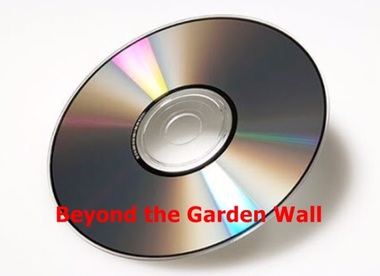
Compact disc, Susan Jane Mercy Barnett et al, Beyond the garden wall: twenty-two gardeners and their gardens, 2008
... Neighbourhood Centre Inc. with funding from the Victorian Department... from the Victorian Department of Planning and Community ...This film documents part of the project "Beyond the Garden Wall". It was devised and managed by a team at Surrey Hills Neighbourhood Centre Inc. with funding from the Victorian Department of Planning and Community Development under the "Images of Age' grant 2007.This video presentation focuses on gardening and its place in the lives of 22 seniors from across the City of Boroondara. The owners of the gardens speak about their earliest recollections of gardens and gardening, influences and inspiration, benefits and frustrations and above all its pleasures.gardening, boroondara, anecdotes, (ms) jo reitze, (ms) susan barnett, taxidermist, gardens, glenburn bend park, birds, (ms) julie morrison, (ms) ann scally, (mr) gary hegedus, (ms) nola sharp, (ms) carol blackett-smith, (ms) sheryl pascoe -
University of Melbourne, Burnley Campus Archives
Plan, Glenferrie PR. S. No. 1508: Detail Survey, 1982
... plans of Glenferrie Primary School for the Department... copies of Public Works Department, Victoria plans of Glenferrie ...Original and 2 copies of Public Works Department, Victoria plans of Glenferrie Primary School for the Department of Education SU 2241.2. Shows site plan of area bounded by Manningtree Road and Wattle Road. Pit Schedule of storm water and sewer pits.glenferre primary school, survey, victoria public works department, storm water, trees, p. manley (draftsman) -
 Greensborough Historical Society
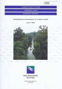
Pamphlet, Lower Plenty River concept plan, summary report: Maroondah Pipetrack to Yarra River, 1992_07
... and Department of Planning and Housing.... Valley, City of Heidelberg, the EPA and Department of Planning ...This draft concept plan covers the lower Plenty River from the Maroondah Pipe track in Greensborough to where the Plenty meets the Yarra. Melbourne Water was the lead agency, assisted by the Shires of Eltham and Diamond Valley, City of Heidelberg, the EPA and Department of Planning and Housing.Coloured pamphlet, photograph and plans 12 pages. 2 copies.plenty river, maroondah aqueduct, melbourne water -
Melbourne Tram Museum
Document - Digital Image, Department of Transport, "Melbourne's Tram Plan", Oct. 2023
... during Oct. 2023, outlining the Department's planing... Oct. 2023, outlining the Department's planing for the future ...Document produced by the Victorian Department of Transport during Oct. 2023, outlining the Department's planing for the future. Has a Ministerial Forward by The Hon Ben Carroll MP. Includes a Table of Contents - looking at Why Trams, Challenges, Strategic Response, future state, and three Key Actions and Timeframes. Does not provide details of any new routes and timelines. See item 7365 for a response by the Victorian Transport Action Group.Yields some information about the future planning for Melbourne Tramways from a Vic Govt viewpoint at the time.Digital copy of a 36 A4 page document produced by the Victorian Dept of Transport Oct. 2023tramways, victorian government, department of transport, planning, ben carroll -
Whitehorse Historical Society Inc.
Newspaper - Article, The Nunawading Post, Housing for low income people
... Victoria. Department of Planning and Development... by the Department of Planning and Development at Rooks Rd... Council Victoria. Department of Planning and Development Atkinson ...Article in Nunawading Post. official opening of 12 room rooming house in Rooks Road, Nunawading on site of the previous Eastbridge Migrant hostel. The rooming house is just part of the multi-million dollar housing complex being developed by the Department of Planning and Development at Rooks Rd, it will be for low income single people.accommodation, outer east regional housing council, victoria. department of planning and development, atkinson, bruce, cameron, athol, baker, heather -
 Whitehorse Historical Society Inc.
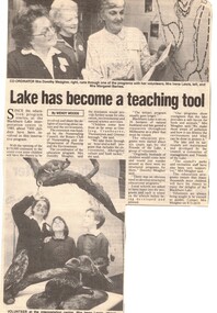
Article, Lake has become a teaching tool, 1/07/1992 12:00:00 AM
... victoria. department of planning and the environment..., Rotary Club of Nunawading and the Victorian Department.... department of planning and the environment rotary club of nunawading ...Nunawading Gazette, 1 July 1992 about Blackburn Lake Interpretation Centre which commenced in 1985.An article in Nunawading Gazette, 1 July 1992 about Blackburn Lake Interpretation Centre which commenced in 1985. $170,000 extension has been opened to teach children about nature and the environment. The extension was funded by the City of Nunawading, Rotary Club of Nunawading and the Victorian Department of Planning and the Environment. The coordinator is Dorothy Meagher. Nunawading Gazette, 1 July 1992 about Blackburn Lake Interpretation Centre which commenced in 1985.primary education, city of nunawading, victoria. department of planning and the environment, rotary club of nunawading, meagher, dorothy, aborigines, blackburn lake sanctuary, friends of the lake, lewis, irene, barnes, margaret, hopkins, sophie, oettinger, marc -
 Bendigo Historical Society Inc.
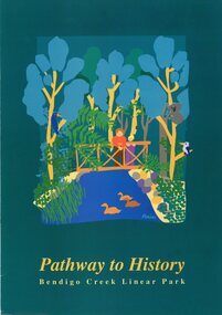
Pamphlet - MERLE HALL COLLECTION: ROSALIND PARK CREATIVE VILLAGE BENDIGO PROJECT PAMPHLET, 1993
... of Greater Bendigo and the Department of planning and development... Bendigo and the Department of planning and development. Production ...MERLE HALL COLLECTION: ROSALIND PARK CREATIVE VILLAGE BENDIGO PROJECT PAMPHLET Pathway to History Bendigo Creek Linear Park Inside pages - Graphic image of the Linear Park from Alexandra Fountain to the Botanical Gardens, includes Rosalind Park, Golden Dragon Museum, Shamrock Hotel, Bendigo Gas Works, Chinese Joss House, Chinese Tea House, Lake Weroona, Wetlands, White Hill Cemetary and mine sites. On outside pages, cover, historical notes on Bendigo and Notes on the Bendigo Creek Linear Park. Notes on the back cover: A joint project of the City of Greater Bendigo and the Department of planning and development. Production by the Publick Affairs Branch, Department of Planning and Development. Printed in Bendigo June 1993 4360/93.