Showing 443 items
matching plotting
-
 Bendigo Historical Society Inc.
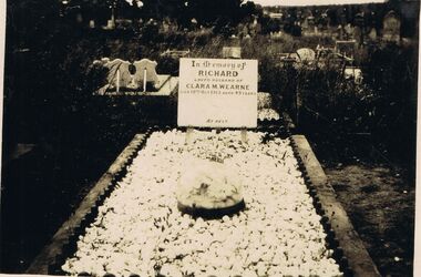
Photograph - BLACK AND WHITE PHOTO MOUNTED ON CARDBOARD
BLACK AND WHITE PHOTO mounted on cardboard. Cemetery plot in the name of Richard Wearne.photograph, building, church -
 Bendigo Military Museum
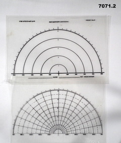
Accessory - PROTRACTOR
... Plotting ...Item in the collection re Craig Triffett. Refer Cat No 5997.5 for his service details.1. This is a clear piece of flexible plastic. It has 180 degree arc markings on it. The reference line is at the bottom. Internal rings have numbers marked on them, i.e. 1,2,3,4,5. The outside ring has graduations in 1*. At the bottom are words "Observers Location - Grid", and "Altitude". Scale 1:50000 Army Form B 6716 (1971). 2. Similar to above, but slightly cropped. No explanatory notes.artillery, plotting, protractor, -
 University of Melbourne, Burnley Campus Archives
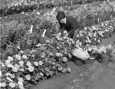
Photograph - Black and white print, Student Picking Flowers, c. 1969
Black and white photograph. Student picking flowers and placing them in buckets in the student plots.students, flowers, publicity, students working outside -
 University of Melbourne, Burnley Campus Archives
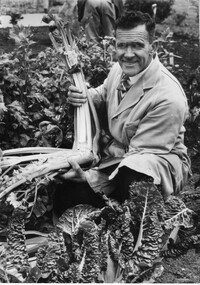
Photograph - Black and white print, College photographs, W.J. Nicholls, 1946-1979
Black and white photograph. Bill Nicholls (Field Superintendent) holding a bunch of celery in the vegetable plots.w.j. nicholls, bill nicholls, field superintendent, vegetables, orchard, publicity -
 University of Melbourne, Burnley Campus Archives
Photograph - 35mm Colour slides, Vege Plots, 1963-1979
6 slides labelled Aug 63: 22. "Veg Plots" 24. "Vege Plots 1963 Russel B.H.C.". 27. "1963 Vege Plots Weighing in Colin Harris" (1965). 32. Jack Russel (Staff) Max Jeffery (1965) Gwen Pump (1964) Students Dip II 1962". Jun 78 "Balling Street Trees". 14 Mar-Aug 79 unidentified. 1.Almond tree in blossomvegetable plots, burnley horticultural college, colin harris, jack russel, staff, max jeffery, gwen pump, students mar-aug 79 unidentified., arboriculture -
 Bendigo Military Museum
photograph - AUTOMAP 1 Production – Army Survey Regiment, Fortuna, Bendigo, c1980
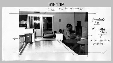
This collection of 20 photos was most likely taken in 1980. The AUTOMAP 1 computer assisted cartography and mapping system was introduced in 1975. The components of AUTOMAP 1 were the Input Sub-System of four Wild B8s stereoplotters and three Gradicon digitising tables, the Optical Line Following Sub-System – Gerber OLF, the Verification Sub-System – Gerber 1442 drum plotter, the General Purpose Sub-system – HP21MX computer and the Output Sub-System – Gerber 1232 flatbed plotter). The first map was published in 1978 (Strickland 3665-3, 1:50,000). AUTOMAP 1 was the first computer assisted cartography and mapping system utilised by the Survey Corps and was the first system used by Australian mapping organisations. The history of the AUTOMAP 1 system is covered in more detail with additional historic photographs, in pages 116-118 of Valerie Lovejoy’s book 'Mapmakers of Fortuna – A history of the Army Survey Regiment’ ISBN: 0-646-42120-4. See items 6410.24P, 6183.19P, 6184.20P, 6200.5P, and 6222.17P for additional photographs of the AUTOMAP 1 system.This is a set of 20 photographs of Air Survey Squadron military and civilian personnel operating AUTOMAP 1 equipment at the Army Survey Regiment at Fortuna, Bendigo, c1980. The photographs were on 35mm negative film and were scanned at 96 dpi. They are part of the Army Survey Regiment’s Collection. Photos .19P and .20P are printed on photographic and scanned at 300 dpi. .1) - Photo, black & white, c1980, Gerber plotter. .2) - Photo, black & white, c1980, Gerber plotter, LT Rob John .3) - Photo, black & white, c1980, Gradicon edit table, SPR Jamie McRae .4) - Photo, black & white, c1980, Gradicon edit table, SPR Steve Linane .5) - Photo, black & white, c1980, 1130 System administration, unidentified. .6) - Photo, black & white, c1980, Wild B8 stereo plotter, SPR Van Dalen? .7) - Photo, black & white, c1980, Wild B8 stereo plotter, SPR Van Dalen? .8) - Photo, black & white, c1980, Gerber Optical Line Follower (OLF). .9) - Photo, black & white, c1980, Gerber OLF. .10) - Photo, black & white, c1980, Gerber OLF. .11) - Photo, black & white, c1980, Gerber OLF. .12) - Photo, black & white, c1980, Gerber OLF. .13) - Photo, black & white, c1980, Data management, CPL Greg Gilbert. .14) - Photo, black & white, c1980, Data management, CPL Greg Gilbert. .15) - Photo, black & white, c1980, 1130 Operating System administration, SGT Denis Marshall. .16) - Photo, black & white, c1980, Programming System, L to R: unidentified, SGT Alan Toogood. .17) - Photo, black & white, c1980, Programming System, L to R: Robert Cox, WO1 Bob Mason, John Dean. .18) - Photo, black & white, c1980, Programming System, L to R: Robert Cox, WO1 Bob Mason, John Dean. .19) - Photo, black & white, c1980, Gradicon edit table, CPL Chris Carter. .20) - Photo, black & white, c1980, Gerber plotter, LT Rob John..1P to .18P - No personnel are identified .19P - ‘CPL Chris Carter’ annotated on backroyal australian survey corps, rasvy, army survey regiment, army svy regt, fortuna, asr, air survey, automap -
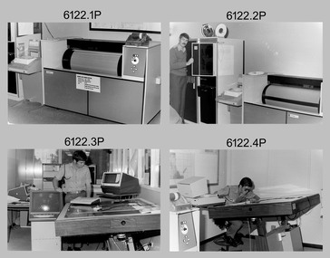
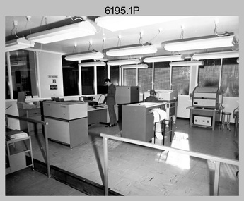
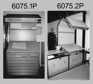 Bendigo Military Museum
Photograph - Equipment used in Map Production at the Army Survey Regiment, 1991
These nine photographs of technical equipment were provided to the Directorate of Survey as input to the 1990-1991 Annual Report. The equipment in Photos .1P and .2P were used to evaluate/validate colour values on printed maps. The equipment in Photo .3P is a daylight film processor. The Optronix 5040 Laser Scanner/Plotter was shown in Photos .4P to .6P. The Print Room’s Map Handling Station in photo .7P provided ergonomic benefits to the Printer Technician and improved despatching productivity. The Optical Disk Archive and Retrieval System (ODARS) equipment in .8P was optical "platter" disk technology for the secure and long term archive storage of large amounts of digital map data. Map data was transferred from large reels of magnetic tape. As most map type (letters and names) generation was done in Automap 2, The ITEK Typesetter shown in photo .9P was close to obsolete in 1991. At this time it was used to generate map type for other RASvy units, contractors and sections still performing manual map production at Army Svy Regt.This is a set of photographs of Army Survey Regiment technical equipment taken in 1991. The photographs were printed on photographic paper and are part of the Army Survey Regiment’s Collection. The photographs were scanned at 300 dpi. .1) - Photo, black & white, 1991, Colour Evaluation Workstation No 1, Lithographic Squadron .2) - Photo, black & white, 1991, Colour Evaluation Workstation No 2, Lithographic Squadron .3) - Photo, black & white, 1991, Daylight film processor, Lithographic Squadron, Daylight Working Contacting Frames in background. .4) - Photo, black & white, 1991, Optronix 5040 Laser Scanner/Plotter, Lithographic Squadron .5) - Photo, black & white, 1991, Optronix 5040 Laser Scanner/Plotter, Lithographic Squadron .6) - Photo, black & white, 1991, Optronix 5040 Laser Scanner/Plotter, Lithographic Squadron .7) - Photo, black & white, 1991, Map Handling Station, Lithographic Squadron .8) - Photo, black & white, 1991, Optical Disk Archive and Retrieval System (ODARS), Cartographic Squadron .10) - Photo, black & white, 1991, Optronix 5040 Laser Scanner/Plotter, Lithographic Squadron .9) - Photo, black & white, 1991, ITEK Typesetter, Cartographic Squadron.1P, .2P, .4P to .10P – equipment description annotated on back .3P - no annotation.royal australian survey corps, rasvy, army survey regiment, army svy regt, fortuna, asr, litho, automap -
 University of Melbourne, Burnley Campus Archives
Album - Colour 35mm slides, D-B Plots Nowa-Nowa, 1969
Box of slides labelled "D-B Plot Nos 1 & 2 Nowa-Nowa August 1969.nowa-nowa, 1969, db plots -
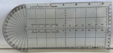 Moorabbin Air Museum
Instrument (item) - Plotter, Bearing And Distance Mark 1 A
Store Ref. No. 6B/135 No 362/40 -
 Bendigo Historical Society Inc.
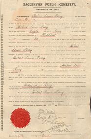
Document - GERTRUDE PERRY COLLECTION: CERTIFICATE OF TITLE BURIAL PLOT, 1911
Document. Certificate of title Burial plot. Eaglehawk Public Cemetery Certificate of Title and receipts for Burial Plot purchased by Herbert Louis Perry. 15th December 1911. Register No. 7310 Compartment No. 02, 11 Baptist Section. Document has Municipality of Eaglehawk Red Seal.document, certificate, gertrude perry collection, gertrude perry collection, herbert louis perry, eaglehawk pupblic cemetry, certificate of title burial plot -
 Dandenong/Cranbourne RSL Sub Branch
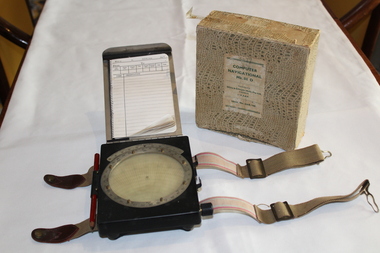
Equipment - RAAF Navigational Computer, White and Gillespie (Melb.) Pty Ltd, Possibly 1940
WWII Historical significanceRAAF Navigational computer MK111 D used in WW11 in aircraft for plotting direction and wind speed with original box.Identification number G6B/145. Serial No WG/2677*. Contains original pencil from 1940 and navigational notebook. -
 Bendigo Historical Society Inc.
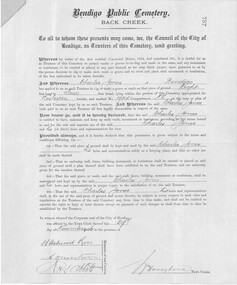
Document - RECEIPT & TITLE FOR CEMETERY PLOT FOR CHARLES JONES, WESLEYAN SECTION, PLOT NUMBER 19114, DATED 29 NOVEMBER 1906
Receipt and Title for a cemetery plot at the Bendigo Public Cemetery in the name of Charles Jones, dated 29 November 1906. Plot number 19114 in the Wesleyan Section, eight feet by four feet Title numbered 787 Receipt on blue paper numbered 3553, for two pounds from Charles JonesBendigo Public Cemetery Trust -
 Buninyong Visitor Information Centre
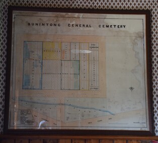
Plan - Cemetery Plan, Buninyong General Cemetery
Plan of the complete layout of the Buninyong General Cemetery drawn by Robert [surname unclear] on 6 April 1871.Framed and glazed original large hand drawn plan of the Buninyong General Cemetery, showing the locations of denominational sections and plots. Buninyong General Cemeterycemeteries, historic sites, buninyong -
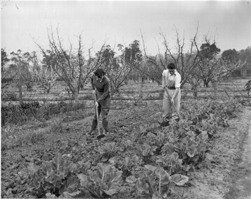 University of Melbourne, Burnley Campus Archives
Photograph - Black and white print, Hoeing Cabbages, 1951
Black and white photograph. Margot George and Peter Smith in the vegetable plots hoeing weeds. In the background the fruit trees are in blossom.margot george, peter smith, vegetable plots, students working outside, orchard, cabbages, fruit trees -
 Bendigo Military Museum
Photograph - Aerotriangulation Production – Army Survey Regiment, Fortuna, Bendigo, c1979
This collection of 19 photos was most likely taken in 1979 in Air Survey Squadron. The PDP 11/70 minicomputer shown photos .2P to .3P was the operating system introduced in 1977 as the mainframe system for the control of the APC4, aerial triangulation block adjustments, SORA OP Analytical Orthophoto control, APR Analytical Terrain Profile Recorder computation, graphics, and general computing. The Zeiss (Jena) Stecometer analytic stereocomparator for air photography shown in photos .5P to .9P was introduced at Air Survey Squadron in 1963. Aerotriangulation production was expedited using computers for analytical photogrammetric processes. The technician accurately measured between pass, tie, and survey control points on aerial photographs. The OMI/Nistri AP/C-3 analytical plotter shown in photos .10P and .11P was introduced in 1972–1973. Photo .11P shows a coordinatorgraph attached to the AP/C-3. The Zeiss D2 Planimat Stereoplotter shown in photo .12P was used for analytical orthophoto control. Wild PUG4 point transfer devices shown in photos .17P to .19P were introduced in c1968 superseding the PUG2 devices. PUG4 devices were used by technicians to stereoscopically view the photography containing the survey control points and the mapping aerial photography. The Control points were transferred from the control photography to the mapping diapositives of aerial photography by drilling their locations into the photographic emulsion.This is a set of 19 photographs of Air Survey Squadron personnel operating aerotriangulation equipment at the Army Survey Regiment at Fortuna, Bendigo, c1979. Black and white photos are on photographic paper and were scanned at 300 dpi. They are part of the Army Survey Regiment’s Collection. .1) - Photo, black & white, c1979, Aerotriangulation tasks, unidentified technicians. .2) to .3) - Photo, black & white, c1979, PDP-11 minicomputers tasks, unidentified technician. .4) - Photo, black & white, c1979, Aerotriangulation tasks, unidentified technician. .5) - Photo, colour, c1979, Zeiss (Jena) Stecometer, unidentified technician. .6) to.9) - Photo, black & white, c1979, Zeiss (Jena) Stecometer, unidentified technician. .10) - Photo, black & white, c1984, OMI/Nistri APC/3-1 analytical stereoplotter, SPR Kristin (Isaac) Skidmore. .11) - Photo, colour, c1979, OMI/Nistri APC/3-1 analytical stereoplotter, unidentified technician. .12) - Photo, colour, c1979, Zeiss D2 Planimat Stereoplotter, unidentified technician. .13) - Photo, black & white, c1979, Aerotriangulation tasks, unidentified technician. .14) - Photo, black & white, c1979, Aerotriangulation tasks, unidentified technician. .15) - Photo, black & white, c1979, Aerotriangulation tasks, CPL Ken Talbot-Smith .16) - Photo, black & white, c1979, Aerotriangulation tasks, SPR David Jobe. .17) - Photo, black & white, c1979, Wild PUG4 point transfer device, WO2 Brian Mead. .18) - Photo, black & white, c1979, Wild PUG4 point transfer device, CPL Andy Wilson. .19) - Photo, black & white, c1979, Wild PUG4 point transfer device, unidentified technician..5P is annotated ‘OMI-Nistri AP/C Analytical Plotter’ and ’Topo 36’. .12P is annotated ‘Zeiss Jena Stecometer Stereocomparator’ and ’Topo 35’. There are no annotations on the other photos.royal australian survey corps, rasvy, army survey regiment, army svy regt, fortuna, asr, aerotrig, air survey -
Whitehorse Historical Society Inc.
Newspaper - Article, Kids Plot A Story, 1991
Kids Plot A Story - 'Cluey Writing' project at Blackburn Lake Primary School under guidance of author Hazel Dean. With photo.blackburn lake state school, no. 4860, cluey writing, artists in schools project, dean, hazel, primary schools -
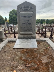 Kew Historical Society Inc
Photograph (Item) - Native Digital Image, Judd Family Grave, Boroondara General Cemetery, 2020, 31/03/2020
thomas judd, parkhill, 20 hillcrest avenue -
Whitehorse Historical Society Inc.
Document, The Wakefields
Wakefield family tree and burial plot of John Wakefield in Boroondara General Cemetery, High Street, Kew.Wakefield family tree and burial plot of John Wakefield in Boroondara General Cemetery, High Street, Kew. The family lived in Blackburn North,Wakefield family tree and burial plot of John Wakefield in Boroondara General Cemetery, High Street, Kew. wakefield family, wakefield, john -
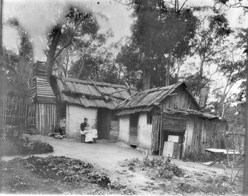 University of Melbourne, Burnley Campus Archives
Photograph - Black and white print, Early Settlers's House, Unknown
Black and white photograph. Hand constructed house in a bush setting. Woman seated in front with 2 children. Garden/vegetable plots in the foreground.hand constructed house, bush setting, garden, vegetable gardens -
 City of Moorabbin Historical Society (Operating the Box Cottage Museum)
Certificate - Document, receipt burial 1890 Martha Jones, c1880
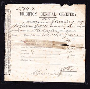
James Jones was the son of Philip Jones, a Chairmaker, and Ann Jones who settled in East Brighton after the sale of land c1852 in the area of the Henry Dendy Special Survey of 1841. Mary Ann Moore was the daughter of Thomas Moore, a Gardener, and Sarah Harris who also settled in Brighton c1852. James and Mary Ann Jones settled and raised their family in East Brighton now Bentleigh. Mr John Herron resided at 4 Vickery St Bentleigh until 1989. Sadly Martha Jones born 1888 died in 1890 and James Jones had to purchase a plot at Brighton General Cemetery for her burial. A further 2 children were interred in 1893 and 1900 then Mary Ann in 1903 and James in 1940James Jones and Mary Ann Moore were born in Brighton c1857 and c 1859 into pioneer market gardener families in the area of the Dendy Special Survey of 1841. They married in 1883 and raised their family in East Brighton, now Bentleigh. Sadly infectious diseases took the lives of many infants throughout the Colony of Victoria due to the poor state of water supply and sewerage disposal and locally the swamps of the Elster Creek were a constant breeding ground. Martha Jones born 1888 died 1890 and was interred in Brighton General Cemetery in a family plot purchased by her father James Jones. An original paper receipt No. 2844 for payment 22 January 1890 by James Jones to Brighton General Cemetery of 3 pounds 1 shilling for burial of Martha Jones aged approx. 2 years in a plot 4 feet x 8 feet. Fees include family grave at 2 pounds 2 shillings, Sinking to 7 feet at 14 shillings and Label 5 shillings .No. 2844( hand written) / BRIGHTON GENERAL CEMETERY / RECEIVED 22 January 18 90 / of Mr James Jones ( hand written ) the sum of £3. 1 being the / following charges in Wesleyan Portion No. / Compt. Name of deceased Martha Jones / Signed S Simmonds (handwritten) Secretary Along left side G.H Orford Printer “ Southern Cross Office” Bay St. Brighton melbourne, brighton, moorabbin, water supply, pioneers, bentleigh, dendy henry, market gardeners, early settlers, jones mary ann, wesleyan church, jones james, vaccination, typhoid, dendys special survey 1841, infectious diseases, elster creek, jones martha, brighton general cemetery, orford g h, printers, southern cross office, bay street brighton -
 City of Moorabbin Historical Society (Operating the Box Cottage Museum)
Certificate - Document, receipt Burial 1893 Ethel May Jones, c1890
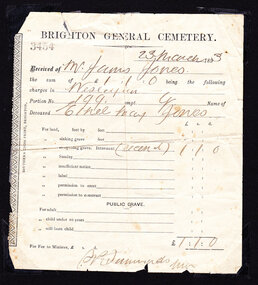
James Jones was the son of Philip Jones, a Chairmaker, and Ann Jones who settled in East Brighton after the sale of land c1852 in the area of the Henry Dendy Special Survey of 1841. Mary Ann Moore was the daughter of Thomas Moore, a Gardener, and Sarah Harris who also settled in Brighton c1852. James and Mary Ann Jones settled and raised their family in East Brighton now Bentleigh. Mr John Herron resided at 4 Vickery St Bentleigh until 1989. Sadly Martha Jones born 1888 died in 1890 and James Jones had to purchase a plot at Brighton General Cemetery for her burial. Baby Ethel May was interred in 1893 and another baby in 1900 then Mary Ann in 1903 and James in 1940James Jones and Mary Ann Moore were born in Brighton c1857 and c 1859 into pioneer market gardener families in the area of the Dendy Special Survey of 1841. They married in 1883 and raised their family in East Brighton, now Bentleigh. Sadly infectious diseases took the lives of many infants throughout the Colony of Victoria due to the poor state of water supply and sewerage disposal and locally the swamps of the Elster Creek were a constant breeding ground. Martha Jones born 1888 died 1890 and was interred in Brighton General Cemetery in a family plot purchased by her father James Jones. In 1893 another daughter Ethel May died and was buried in the family plot. An original paper receipt No. 3454 for payment on 23 March 1893 by James Jones to Brighton General Cemetery of £1 . 1s For the burial of baby Ethel May Jones in a plot 4 feet x 8 feet, in the Wesleyan section portion 199 compartment G. Fee was for reopening the grave he had purchased in 1890 for the burial of his daughter Martha, aged 2 years . BRIGHTON GENERAL CEMETERY / 3454 ( stamped) / 23 March 1893 ( hand written ) / Received from Mr James Jones ( hand written ) / the sum of £1 . 1s being the following / charges in Wesleyan (hand written) / Portion No, 199 compt.G Name of / deceased Ethel May Jones ( handwritten) / for re-opening grave internment recent ( hand written) £1 . 1s / Signed S Simmonds ( ?manager) Along left side of receipt is printed SOUTHERN CROSS PRINT, BRIGHTON melbourne, brighton, moorabbin, water supply, pioneers, bentleigh, dendy henry, market gardeners, early settlers, jones mary ann, wesleyan church, jones james, vaccination, typhoid, dendys special survey 1841, infectious diseases, elster creek, jones martha, brighton general cemetery, orford g h, printers, southern cross office, bay street brighton, jones ethel may -
 Whitehorse Historical Society Inc.
Photograph, Nunawading Community Garden
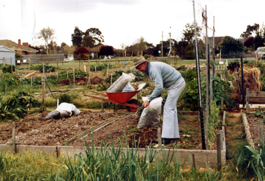
Coloured photograph of gardener attending his plot at the Nunawading Community Gardens in Jolimont Road, Forest Hill c1980. the gardens were opened in 1977community gardens, city of nunawading, nunawading community garden, parks and reserves -
 Bendigo Military Museum
Photograph - AUTOMAP 1 Production – Army Survey Regiment, Fortuna, Bendigo, c1978-1980
This collection of 20 photos was most likely taken in c1978. The AUTOMAP 1 computer assisted cartography and mapping system was introduced in 1975. The components of AUTOMAP 1 were the Input Sub-System of four Wild B8s stereoplotters and three Gradicon digitising tables, the Optical Line Following Sub-System – Gerber OLF, the Verification Sub-System – Gerber 1442 drum plotter, the General Purpose Sub-system – HP21MX computer and the Output Sub-System – Gerber 1232 flatbed plotter). The first map was published in 1978 (Strickland 3665-3, 1:50,000). AUTOMAP 1 was the first computer assisted cartography and mapping system utilised by the Survey Corps and was the first system used by Australian mapping organisations. The history of the AUTOMAP 1 system is covered in more detail with additional historic photographs, in pages 116-118 of Valerie Lovejoy’s book 'Mapmakers of Fortuna – A history of the Army Survey Regiment’ ISBN: 0-646-42120-4. See items 6122.20P, 6410.24P, 6183.19P, 6200.5P, and 6222.17P for additional photographs of the AUTOMAP 1 system.This is a set of 20 photographs of Air Survey Squadron military and civilian personnel operating AUTOMAP 1 equipment at the Army Survey Regiment at Fortuna, Bendigo, c1978-1980. Black and white photos .1P to .18P are on photographic paper and were scanned at 300 dpi. Photo .4P is in colour and mounted with a duplicate on manilla card. Black and white photos .19P to .20P are on 35mm negative film and scanned at 96 dpi.They are part of the Army Survey Regiment’s Collection. .1) - Photo, black & white, c1978-1980, Gerber Optical Line Follower (OLF), SSGT John Bennett. .2) - Photo, black & white, c1978-1980, HP21MX computer General Purpose Sub-system. .3) - Photo, black & white, c1978-1980, Gerber OLF .4) - Photo, colour, c1978-1980, unidentified digitising on Gradicon edit table. .5) - Photo, black & white, c1978-1980, Gerber verification drum plotter. .6) - Photo, black & white, c1978-1980, Gerber OLF, CAPT Rob Bridge. .7) - Photo, black & white, c1978-1980, Programming and system administration, SGT Alan Toogood. .8) - Photo, black & white, c1978-1980, Unidentified digitising on Gradicon edit table. .9) - Photo, black & white, c1978-1980, CPL Rick Downie digitising on Gradicon edit table. .10) - Photo, black & white, c1978-1980, SPR Dave Irving digitising on Gradicon edit table. .11) - Photo, black & white, c1978-1980, Gerber OLF and CPL Rick Downie. .12) - Photo, black & white, c1978-1980, 1130 Computer System administration, L to R: unidentified, SSGT Les Dixon, SPR Geoff Havelberg. .13) - Photo, black & white, c1978-1980, AUTOMAP 1 tape administration, Maryanne De Groot. .14) - Photo, black & white, c1978-1980, AUTOMAP 1 tape drive. .15) - Photo, black & white, c1978-1980, HP21MX computer General Purpose Sub-system. .16) - Photo, black & white, c1978-1980, digitising topographic features with a Wild B8 stereo plotter, L to R: unidentified, CPL John Smith. .17) - Photo, black & white, c1978-1980, digitising topographic features with a Wild B8 stereo plotter, CPL John Smith. .18) - Photo, black & white, c1978-1980, digitising topographic features with a Wild B8 stereo plotter, CPL Adrian Rynberk. .19) - Photo, black & white, c1978-1980, Programming and system administration, SGT Alan Toogood. .20) - Photo, black & white, c1978-1980, Gerber OLF, CPL Chris Edwards. .1P to .20P - No personnel are identified.royal australian survey corps, rasvy, army survey regiment, army svy regt, fortuna, asr, automap 1 -
Federation University Historical Collection
Plan - Drawing, Engineering Drawing - Surveying, c1995
A set of 3 sgeets of field data, plotted on a 360 degree protractor grid. .1) Station 4 .2) Station 5 .3) Station 6surveying examination, field date, protractor grid, griffiths pryor -
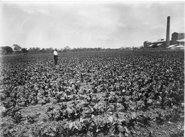 University of Melbourne, Burnley Campus Archives
Photograph - Black and white print, H.B. Hammond Photo, A Crop of Sugar Beet. Maffra, Unknown
Black and white photograph. Crop of sugar beet in a paddock with a man standing in the middle of it and a draught horse in the background. Sugar beet mill on right side.Caption on front, "A Crop of Sugar Beet. Maffra." On reverse, "A Government experimental plot of beets grown near the factory."crop, sugar beet, maffra, government experimental plot, mill, government factory, sugar beet mill -
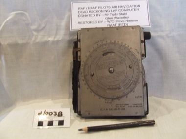 Waverley RSL Sub Branch
RAAF Navigation Computer
Used by RAF and RAAF during WWII Believed to have been used in the battle of britainMetal faced bakelite box with rotating dial on front and a paper graph sheet enclosed in front cover a pencil for plotting course and position is attached to the side of the unitNavigational Computer ICANican computer, battle of britian computer, aircraft computer, mechanical computer -
Glenelg Shire Council Cultural Collection
Certificate - Certificate - Right of Burial Portland Cemeteries, Portland, Victoria, 20/08/1928
Certificate of Right of Burial, Portland Cemeteries. Purchase of burial plot by William Vivian from trustees of the Portland Cemeteries. Printed form details handwritten in black ink. -
Stawell Historical Society Inc
Map, Western Mining Corporation Limited, Shaft Location Plan April 1981, 1981
Western Mining Corporation Ltd Shaft Location Plan 1981 Very Large Plot Showing Contours and Streets Without names. Sheet 1 0f 2 stawell, mining -
Stawell Historical Society Inc
Map, Western Mining Corporation Ltd Shaft Location Plan 1981, 1981
Western Mining Corporation Ltd Shaft Location Plan 1981 Very Large Plot Showing Contours and Streets Without names. Sheet 2 0f 2 stawell, mining -
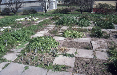 University of Melbourne, Burnley Campus Archives
Slide - 35mm Colour slides, Burnley Bulb Bed, C. 1998
bulbs, field station, growing trials