Showing 55 items matching "public highways"
-
 Ballarat Heritage Services
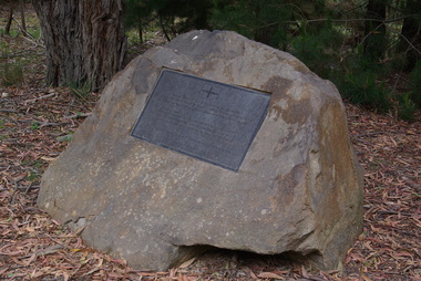
Photograph - Photograph - Colour Digital, Ballarat Reform League Inc Monument at Buninyong, 12/11/2012
Before the end of August 1851 the government had decided to charge a large licence fee for the right to search for gold. When news of that decision reached the Buninyong diggings, the first protest on the Victorian goldfields was held. The monument to that meeting has been placed at the site where it is believed that the meeting took place, in Hiscock Gully Road, about 400 metres from the Midland Highway.Colour photograph of a rock with a commemorative plaque outlining goldfields agitation at Buninyong.The plaque on the monument reads:- "Plaque on the Ballarat Reform League Inc. Monument at Buninyong, 2012. After the discovery of gold at Buninyong in August 1851 the government announced that the diggers would be charged a large licence fee. The injustice of that decision sparked a public protest here at the diggings. 'Buninyong 26 August - Tonight for the first time since Australia rose from the bossum of the ocean, were men strong in their sense of right, lifting up a protest against an impending wrong, and protesting against the Government. (Melbourne Argus, 20 August 1851)"ballarat reform league inc, goldfields agitation, buninyong monument, eureka stockade -
 Bayside Gallery - Bayside City Council Art & Heritage Collection
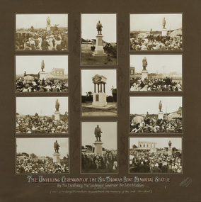
Photograph - gelatin silver photograph, R. McGeehan, Unveiling Ceremony of the Sir Thomas Bent Memorial Statue, 1913
politician, mayor, premier, bust, sculpture, margaret baskerville, speaker, member of parliament, member of lower house, local government, councillor, brighton, public art, bayside, thomas bent, unveiling, ceremony, mayoress, sculptor, councillor wilson, crowd, 1913, nepean highway, mrs bent, elizabeth bleazby, fountain, memorial, john madden, lieutenant governor -
 Bayside Gallery - Bayside City Council Art & Heritage Collection
Map - print, Melbourne and Metropolitan Board of Works, Interim development order: Brighton, Moorabbin and Sandringham, 1959
The Melbourne and Metropolitan Board of Works (now Melbourne Water) was established in 1891. From that time, as part of their work laying water and sewerage connections, they created detailed plans of houses and other buildings in the Melbourne metropolitan area. In 1956 it acquired powers to construct and maintain highways and bridges, protect and improve the foreshores and create and maintain parks within the metropolitan region. This Interim development order comprises part of the municipalities of Brighton, Moorabbin and Sandringham and was made on 20 October 1959.brighton, moorabbin, sandringham, melbourne and metropolitan board of works, map, town planning, cartographic material, interim development order, bayside -
 Bayside Gallery - Bayside City Council Art & Heritage Collection
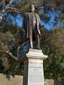
Sculpture, Margaret Baskerville, Sir Thomas Bent, 1913
Arguably Margaret Baskerville’s most famous work, the bronze statue of politician and land speculator Sir Thomas Bent was Baskerville’s first public commission and a significant turning point in her career. Originally located in the centre of the Nepean Highway, in Brighton, it became somewhat of signpost for many Melbournians until it was relocated to the corner of Bay Street in 1980.The statue of Sir Thomas Bent is of historic and social significance to the State of Victoria. The statue is historically significant for commemorating Bent's long, active and infamous political career in Victoria. He was responsible for many important speculative ventures both within his electorate and in the wider context of Victoria. Although not without thought for personal gain, Bent was a committed advocate of public utilities, railways, roads, tramways and gasworks. The statue is historically significant as the first large public commission given to a woman sculptor in Victoria. This work helped the sculptor, Margaret Baskerville, preserve her name as Victoria's first professional woman sculptor. The statue is socially significant as testimony to the late nineteenth century land boom and the financial and political corruption and scandals that accompanied it. https://vhd.heritagecouncil.vic.gov.au/places/12614bronze and granite thomas bent, politician, mayor, premier, bust, sculpture, margaret baskerville, speaker, member of parliament, member of lower house, local government, councillor, brighton, public art, bayside -
 Bayside Gallery - Bayside City Council Art & Heritage Collection
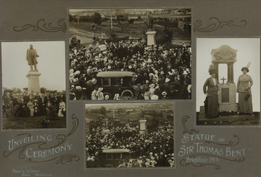
Photograph - gelatin silver photograph, Frazer & Vallance, Unveiling Ceremony, Statue of Sir Thomas Bent, Brighton, 1913
politician, mayor, premier, bust, sculpture, margaret baskerville, speaker, member of parliament, member of lower house, local government, councillor, brighton, public art, bayside, thomas bent, unveiling, ceremony, mayoress, sculptor, councillor wilson, crowd, 1913, nepean highway, mrs bent, elizabeth bleazby, fountain, memorial -
 Glen Eira City Council History and Heritage Collection
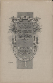
Booklet, "AVENUES OF HONOUR The Councils of the Municipalities of the CITY OF CAULFIELD TOWN OF BRIGHTON acting in conjunction PUBLIC DEMONSTRATION SAT 3rd AUG. 1918 AT 3oCLOCK"
Souvenir Programme from the Councils of the Municipalities of the City of Caulfield and the Town of Brighton for a Public Demonstration to be held on Sat 3rd August 1918 at 3 o'clock for the proposed Avenues of Honour to be planted in memory of fallen WWI soldiers. From Honour Roll Display 2019 interpretation panel - Brighton-Caulfield Avenue of Honour It is hard to imagine but a grand arboreal Avenue of Honour once lined parts of North Road, McMillan Street and Point Nepean Road (now Nepean Highway). The Avenue of Honour was a distinctly Australian phenomenon with hundreds being constructed throughout Australia during and following World War One, most of these in Victoria. Consisting of tree lined streets with each tree representing a solider, the Avenue of Honour signalled a more egalitarian approach to commemoration where rank was not a consideration. Arguably the most famous Avenue of Honour in Victoria still exists at Ballarat. Stretching for nearly 22 kilometres, the entrance to the Avenue is marked by the imposing Arch of Victory. Smaller in scale, the Brighton-Caulfield Avenue of Honour was dedicated to the ‘memory of (Brighton and Caulfield’s) kith and kin who came from (the) district and who died in the Great War’. A joint project between the neighbouring Councils, the idea was first reported in The Argus on 1 July 1918. Plans moved along quickly and on 3 August 1918 the Governor of Victoria Arthur Stanley planted the first Australian flowering gum. The next of kin were then invited to plant trees for lost sons, brothers, uncles, nephews and husbands. In all, over 400 trees were planted. Intensely personal, the Avenue also acted as a focus of grief and remembrance for the wider community. For many years, the annual civic Anzac Day service was held at the Avenue on Point Nepean Road, near Glen Huntly Road, Elsternwick. The service was moved to Caulfield Park upon the completion of the Cenotaph in 1930. Due to road widening and disease the last original tree was replaced in the 1980s, however a plaque in Caulfield Park records the Avenue’s plantation. Commemorative booklet, grey cover with text printed on the grey textured paper cover and an image of four trees and a wreath. Image of a kookaburra on the back. Inside, 28 numbered pages with b/w text and photographic images including a transparent paper representation of the proposed Avenues of Honour on Brighton Road and Point Nepean Road. Souvenir programme for a Public Demonstration for the Avenues of Honour as detailed on the front.city of caufield, world war one, first world war, anzac, remembrance, town of brighton, brighton, caulfield, avenue of honour -
 Glen Eira City Council History and Heritage Collection
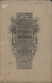
Booklet, D. W. Paterson Co. Pty. Ltd, "AVENUES OF HONOUR The Councils of the Municipalities of the CITY OF CAULFIELD TOWN OF BRIGHTON acting in conjunction PUBLIC DEMONSTRATION SAT 3rd AUG. 1918 AT 3oCLOCK SOUVENIR"
Souvenir Programme from the Councils of the Municipalities of the City of Caulfield and the Town of Brighton for a Public Demonstration to be held on Sat 3rd August 1918 at 3 o'clock for the proposed Avenues of Honour to be planted in memory of fallen WWI soldiers. One of two known copies, this copy has "Town Clerk" stamped in the upper corner, rhs.Commemorative booklet, grey cover with text printed on the grey textured paper and an image of four trees and a wreath. Image of a kookaburra on the back. Inside, 28 numbered pages with b/w text and photographic images including a transparent paper representation of the proposed Avenues of Honour on Brighton Road and Point Nepean Road. Souvenir programme for a Public Demonstration for the Avenues of Honour as detailed on the front. From Honour Roll Display 2019 interpretation panel - Brighton-Caulfield Avenue of Honour It is hard to imagine but a grand arboreal Avenue of Honour once lined parts of North Road, McMillan Street and Point Nepean Road (now Nepean Highway). The Avenue of Honour was a distinctly Australian phenomenon with hundreds being constructed throughout Australia during and following World War One, most of these in Victoria. Consisting of tree lined streets with each tree representing a solider, the Avenue of Honour signalled a more egalitarian approach to commemoration where rank was not a consideration. Arguably the most famous Avenue of Honour in Victoria still exists at Ballarat. Stretching for nearly 22 kilometres, the entrance to the Avenue is marked by the imposing Arch of Victory. Smaller in scale, the Brighton-Caulfield Avenue of Honour was dedicated to the ‘memory of (Brighton and Caulfield’s) kith and kin who came from (the) district and who died in the Great War’. A joint project between the neighbouring Councils, the idea was first reported in The Argus on 1 July 1918. Plans moved along quickly and on 3 August 1918 the Governor of Victoria Arthur Stanley planted the first Australian flowering gum. The next of kin were then invited to plant trees for lost sons, brothers, uncles, nephews and husbands. In all, over 400 trees were planted. Intensely personal, the Avenue also acted as a focus of grief and remembrance for the wider community. For many years, the annual civic Anzac Day service was held at the Avenue on Point Nepean Road, near Glen Huntly Road, Elsternwick. The service was moved to Caulfield Park upon the completion of the Cenotaph in 1930. Due to road widening and disease the last original tree was replaced in the 1980s, however a plaque in Caulfield Park records the Avenue’s plantation. Inkstamp upper corner rhs: "TOWN CLERK" -
 City of Kingston
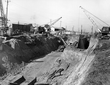
Photograph - Black and white, c. 1958
Moorabbin station sits on the Frankston line which first opened in 1882 when the line was extended from Mordialloc. Moorabbin station opened in 1881 and was originally called South Brighton station. It was renamed Moorabbin station in 1907. In 1958 the station was relocated below street level which coincided with other construction works on Nepean Highway and South Road. This image is part of a larger collection of images from the Public Transport Corporation displaying train stations and streetscapes in what is now the City of Kingston.Black and white photograph showing excavations for Moorabbin station to be moved below street level. Stamped in blue ink on reverse: COPYRIGHT / Public Transport Corporation / For re-ordering photographs / Please quote negative No M6004 / Enquiries C/- PTC Photographic Unit / Telephone switchboard 619 111moorabbin, railway station, construction works, suburbs, nepean highway -
 City of Kingston
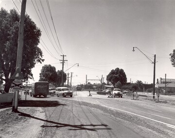
Photograph - Black and white
This photograph depicts the road diversion on Nepean Highway that was implemented to allow construction of the railway line underneath the Nepean Highway at Moorabbin. An "Allourie" Cheese, Honey Canned Ham van is prominent on the left of the image, the railway gates are central and the old Moorabbin Station is visble. Beyond the dates, pedestrians are visible crossing the Nepean Highway. This image is part of a larger collection of images from the Public Transport Corporation displaying train stations and streetscapes in what is now the City of Kingston.In 1958 excavations began for the removal of the level crossing gates at the southern end of the Moorabbin shopping centre on Nepean Highway. The station was also lowered below ground. A diversion route was created to enable the flow of traffic in both directions along the highway.Black and white photograph of road diversion on Nepean Highway, Moorabbin to allow the construction of the railway line below the Nepean Highway at Moorabbin and also to trench the station. This image is part of a larger collection of images from the Public Transport Corporation displaying train stations and streetscapes in what is now the City of Kingston.White adhesive dot sticker: Printed black 199 Handwritten in red ink: 80% Handwritten in black ink on yellow Post-It Note: [indecipherable] 199 - Diversion for Crossing Stamped in blue ink: COPYRIGHT Public Transport Corporation, For reordering photographs, Please quote negative No m 5687, Enquiries C/- PTC Photographic Unit, Telephone switchboard 619 1111railway crossing, railway station, city of moorabbin -
 City of Kingston
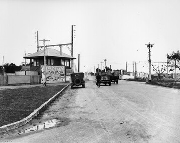
Photograph - Black and white, c. 1930
This image is part of a larger collection of images from the Public Transport Corporation displaying train stations and streetscapes in what is now the City of Kingston.The Nepean Highway is a major highway running through the City of Kingston. This image is one of many that depicts its importance to the local community as it undergoes many changes over time.Black and white photograph depicting the level crossing at Moorabbin. While the gates at the level crossing are open, two cars are making their way across the crossing, while a third car is parked on the side of the road, in front of a large billboard/hoarding for ham and bacon products. There is a man standing on the road as if watching the cars go through the crossing. The road appears to be unsealed. Black printed text on a round white sticker adhered to the reverse: 148 Handwritten in red ink: 60% Blue ink stamped on reverse: COPYRIGHT / Public Transport Corporation / For re-ordering photographs / Please quote negative No ADU907 / Enquiries C/- PTC Photographic Unit / Telephone switchboard 619 111moorabbin, trains, railway crossing, level crossing, cars, roads, nepean highway -
 City of Kingston
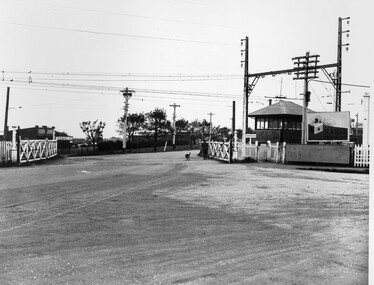
Photograph - Black and white, c. 1930
This image is part of a larger collection of images from the Public Transport Corporation displaying train stations and streetscapes in what is now the City of Kingston.The Nepean Highway is a major highway running through the City of Kingston. This image is one of many that depicts its importance to the local community as it undergoes many changes over time.Black and white photograph depicting railway crossing at Nepean Highway Moorabbin. The level crossing gates are open and a man is walking through with his dog. To the right of the crossing is a billboard/hoarding promoting what appears to be a brand of radio/wireless.White round sticker with indecipherable black printed text which has been scribbled over with black pen. White round sticker with black printed text: 175 Handwritten in red ink: 50% Blue ink stamped on reverse: COPYRIGHT / Public Transport Corporation / For re-ordering photographs / Please quote negative No ADV 903 / Enquiries C/- PTC Photographic Unit / Telephone switchboard 619 111moorabbin, trains, railway crossing, level crossing, nepean highway -
 City of Kingston
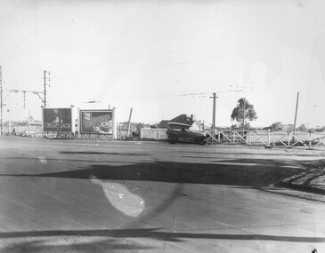
Photograph - Black and white, c. 1930
This image is part of a larger collection of images from the Public Transport Corporation displaying train stations and streetscapes in what is now the City of Kingston.The Nepean Highway is a major highway running through the City of Kingston. This image is one of many that depicts its importance to the local community as it undergoes many changes over time.Black and white photograph of the level crossing at Neapean Highway Moorabbin. Photograph is a slightly side view, with a blurred image of a car approaching the level crossing. The gates are closed. To the left of the image is a pair of billboards. The billboard on the left is promoting Creamoata, a New Zealand brand of oats, and the billboard on the right is promoting Kraft cheese.White round sticker on reverse with black printed text: 147 Handwritten in red ink on reverse: 100% Blue ink stamped on reverse: COPYRIGHT / Public Transport Corporation / For re-ordering photographs / Please quote negative No ADV 1030 / Enquiries C/- PTC Photographic Unit / Telephone switchboard 619 111moorabbin, level crossing, railway crossing, cars, advertising, nepean highway -
 Lakes Entrance Historical Society
Photograph, 1999
In late 1958 bore put down in an attempt to obtain good quality water for a reticulated town water supply. Water unsuitable, but during drought years when water supply from Nicholson River was restricted, water from this bore available for public use. Bore plugged, structure removed December 2000. Site marked with plaque March 2001, by Lakes Entrance Historical Society.Colour photograph of the head works including feed pipe of water bore sunk in late 1958 on the Public Reserve bound by Marine Parade and the highway approach to North Arm Bridge, Lakes Entrance, Victoria.water supply, public utilities -
 Ringwood and District Historical Society
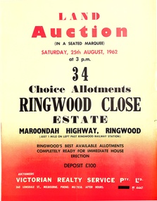
Pamphlet, Land Auction Brochure - Ringwood Close Estate, Ringwood, Victoria - 1962
Brochure advertising public auction of 34 allotments on Saturday 25th August, 1962. Brochure includes terms of sale, description of subdivision features and local facilities, with locality map. Subdivision includes Anthony Court, Nina Court and Wingrove Place, off Maroondah Highway, Ringwood.Auctioneer - Lindsay Lord, Victorian Realty Service Pty Ltd., 360 Lonsdale Street, Melbourne. Phone MU7858, After hours XF4447. Map includes handwritten pricing notations for some allotments. -
 Melbourne Tram Museum
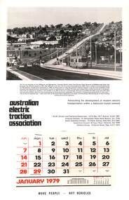
Document - Calendar, AETA 1979 featuring the new Burwood Highway tram line
The AETA published calendars on an annual basis through to 2005, promoting electric transport in Public Transport. The MMTB photo features Z25 inbound on Burwood Highway. The caption gives a description of the project.Yields information about the AETA promotional activities.Australian Electric Traction Association (AETA) Calendar for 1979, featuring a photograph of Burwood Highway with Z class tram 25. Gives contact details for the AETA divisions. Stapled to the sheet is a 12 sheet preprinted calendar for 1979 with various details of holidays etc. Printed on card with a punched hole on the top edge. calendars, aeta, z class, burwood highway, new tramway, tram 25 -
 Falls Creek Historical Society
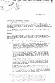
Document - Circular to Lessees and Licensees - Parking and other arrangements for the 1968 season
... . Beauty and the Omeo Highway becoming a public road called... of the road between Mt. Beauty and the Omeo Highway becoming a public ...Bob (Herman) Hymans (a former member of the Royal Netherlands Navy) was born in Bloemendaal, Holland on 30th September 1922. During World War II he fought against the Japanese in the Dutch East Indies (now Indonesia) and was imprisoned in Changi and on the Burma Railway. After gaining qualifications as a Ski Instructor, Bob arrived in Falls Creek in July 1950. Working as an Instructor and Supervisor at Bogong Lodge, Bob decided his future was in accommodation. He was successful in negotiating an indenture for land from the State Electricity Commission (SEC). It took Bob two years to build his Grand Coeur Chalet but, tragically, it was burned down in August 1961. Bob also built the first Chairlift in Australia. This was a single chairlift and the structure was built from wooden electricity poles. He was constantly full of new ideas and proposals for the village. Bob Hymans died on 7th July 2007. This Collection of documents and letters tells the story of Bob's endeavours to develop Falls Creek into the ski village it is today.This item is significant because it documents actions taken by the Falls Creek Tourist Area Management Committee in their role overseeing the Tourist Area.A detailed circular in preparation for the 1968 winter season. Key topics included:- the rezoning of car parking and some roads also involving the opening of the road between Mt. Beauty and the Omeo Highway becoming a public road called the Bogong High Plains Tourist Road; snow clearing on roads and the use of chains; use of "Yellow Horse" shuttle service: slope preparation and the "Ratrac" snow packing machine; chair lift ticket prices; concerns re straying cattle and a water supply and sewerage update. Over the summer some new buildings had been constructed bringing beds available on the mountain to about 1,350 and a clean up of the Village would be organised before the season began. Tobogganing areas were discussed, The need for publicity was stressed and the Committee saw this as the responsibility of those who would benefit most. Consistent approaches to snow reporting, loutishness and garbage were called for. Oversnow transport, Ski School, Snow Patrol were outlined. Finally the need to foster positive relations and a coordinated approach towards public relations was called for.falls creek tourist area management committee, falls creek administration -
 Melbourne Tram Museum
Newspaper, The Emerald Hill, Sandridge and St Kilda Times, "Light Rail: A matter where agreement is hard to get", 23/04/1987 12:00:00 AM
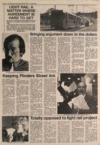
Newspaper cutting from The Emerald Hill, Sandridge and St Kilda Times - 23/4/1987 titled "Light Rail: A matter where agreement is hard to get" about the conversion of the St Kilda and Port Melbourne rail lines to Light Rail. Has three sub-articles, quote the General Manager of The Met Mr. Ed Dotson, Mr Patrick O'Connor Public Transport Users Association about the keeping of the Flinders St link and Mr Noel Willis, the President of the Bayside Public Transport Association who was opposed. Has photos of each of the people involved and a B class tram on route 75 in the Burwood Highway.trams, tramways, light rail, st kilda, port melbourne, conversion, east burwood, route 75 -
 Melbourne Tram Museum
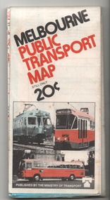
Map, Ministry of Transport, "Melbourne Public Transport Map", c1977
... back to the highway. "Melbourne Public Transport Map" Map ...Fold out map (27 sections 9 across x 3 deep), coloured of Melbourne's Tram and Bus routes, route numbers, rail lines, detailed for the central part of Melbourne and insert section for Frankston. On rear description of routes, private bus routes and map of Melbourne metro lines. Has contact details for bookings and lost property etc. Priced 20c Dated 1977, says No. 6 on bottom of rear cover. Note shows route 59 being cut back to the highway.trams, tramways, melbourne, map, tram & bus services, railways, mmtb, minister for transport -
 Melbourne Tram Museum
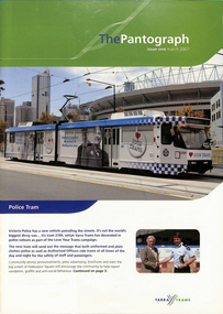
Magazine, Yarra Trams, "The Pantograph", 2007 to 2010
1 - Issue 1 - March 2007 - with photo of the Police Tram (2109) - Welcome message from the CEO Dennis Cliche, Good Friday appeal, Burwood highway works, new sub-stations at Coburg, Royal Park, Brunswick depot, Camberwell depot, East Preston, Essendon, Bundy Clock, Glenhuntly, Kew Depot, Malvern, Southbank,, Safety, events, Lunar Festival .2 - issue 2 - June 2007 - 18 pages, Malvern Depot (a green depot), Paul Matthews profile, trackwork at Glen Huntly and Essendon depots, Depot news, Joyce Barry tribute, Hawthorn depot museum, fund raising. .3 - issue 3 - Octr. 2007 - 16 pages - fund raising - Melbourne city romp, Des Davies retirement, CPR rescue of a collapsed driver, depot news, retirements and a chemical and fire incident on the Vermont South line. .4 - issue 4 - Jan. 2008 - 12 pages - fundraising, family events, depot news, retirements, TramTracker Jake .5 - issue 11 - Winter 2010 - 16 pages - St Kilda Road Superstops, Michel Mason - CEO, Malvern depot centenary, Transformation, new maps on trams, fundraising, the leadership team, depot news, uniforms, South Caulfield Junction upgrade. .6 - 20 pages issue 12, Summer 2010, published soon after Keolis took over operations of Yarra Trams. The first 10 pages, look at Trams on the Fringe, Feedback, Football trams, staff matters, and features a story on page 10 of the Hawthorn Tram Depot museum and Driver Shaun McCarthy wearing the brown uniform in front of tram 1041. Fully Scanned. The second ten pages are reversed (upside down) and titled "Le Pantographer", featuring a Bordeaux tram on the cover. Provides details of Keolis operations such as Lyon, Bordeaux, Lille, Le Mans, Caen, Angers, Dijon and other operations. .7 - issue 6 - Spring 2008 - Meerkats, fleet operations, training, Art Alive, Kew depot - new inspection pits, Long Lay Malvern, Did You Know campaign, and looking for Cricket players - part scanned. .8 - issue 13 - Autumn 2011 - Michel Masson CEO, visit of French Media, Ron Scholten Retirement, photo of Geoff Dean of Camberwell, - part scanned. .9 - issue 5 - June 2008 - Tram works Swanston and Flinders, tram 111, cricket .10 - issue 8 - Autumn 2009 - Good Friday appeal, public transport ombudsman, Malvern centenary, my friend Mike .11 - issue 9 - Spring 2009 - Chris Cairns safety campaign, route 48, Myki, Tramtracker, Jake.Demonstrates Yarra tram staff newslettersEleven issues of Yarra Tram's internal newsletter "The Pantograph", all A4, center stapled. Issues not fully scanned, unless noted.trams, tramways, keolis, yarra trams, fohtd, hawthorn, uniforms, coburg, substation, royal park, burwood highway, fund raising, bundy clock, environment, glenhuntly depot, essendon depot, malvern depot, south caulfield, tram 2109, tram 84, route 48, tram 111, good friday -
 Melbourne Tram Museum
Letter, Australian Electric Traction Association (AETA), "Proposal to build a tramline down Nepean Highway to Southland", May. 1977
Letter with supplementary document - "Proposal to build a tramline down Nepean Highway to Southland", advocating residents support a study into a possible tram line to Southland, May 1977. The Nepean Highway was being widened at the time. Produced by the AETA. Printed by duplicating process on white foolscap paper.trams, tramways, public transport, mmtb, proposals, moorabbin -
 Stawell Historical Society Inc
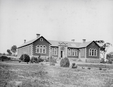
Photograph, Pleasant Creek Hospital 1866
Pleasant Creek Hospital. Part of a collection of Photographs by Mr. O.G. Armstrong as commissioned by the Shire of Stawell for the Inter-colonial and Paris Exhibition in Melbourne in 1866. Due to a public outcry for medical services on the goldfield a public meeting was held in the Olympic Theatre at Deep Lead on the 7th of August 1858. It appointed a 50 man committee to establish a hospital at Pleasant Creek. A temporary Tent structure was soon erected at Doctors Hill, situated midway between Deep Lead and Commercial Street Pleasant Creek, just South of the later Western Highway. The site is now marked by a commemorative stone. Within two months the committee had collected £600 in subscriptions, a government Grant for £2500 and acquired 10 acres of land. The foundation stone of the hospital building was laid on 21st December 1860 and the building completed and occupied by 21st June 1861. In the 1930’s the hospital moved to the centre of Stawell in Sloane Street and the buildings then taken over by the Pleasant Creek Training Centre. Brick hospital building with two ward wings and central front door. Man standing on steps.stawell health -
 Charlton Golden Grains Museum Inc
Photograph, Dunstan Gates, Charlton Showgrounds, c.1960
Dunstan Gates, Charlton Showgrounds. c.1960. Entrance gates to the Showgrounds (Charlton Park) on the Calder Highway. Named after Albert Dunstan, Victorian Premier. A public meeting was reported in the Charlton Tribune 1950, 19/05 deciding to erect a memorial to the late Sir Albert Dunstan. Setting an objective of 5000 pounds. The shire council had given 500 pounds as a lead. It was decided that a memorial gateway with a suitable plaque would be erected in front of Charlton Park in recognition of his service to Charlton, the electorate and the State.B/w photo of the Dunstan Gates c.1960. There are markings left by tape adhesive on the left and right of the photo.charlton, parks, dunstan, charlton park, memorial -
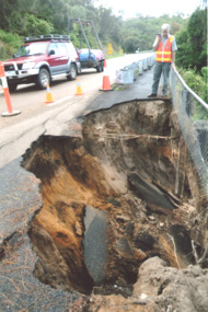 Lakes Entrance Historical Society
Photograph - Princes Highway Lakes Entrance, Lakes Post Newspaper, Landslip Jemmys Point, 1/04/2014 12:00:00 AM
Traffic was reduced to single land temporary traffic lights were installedColour photograph showing a Vic Roads staff member standing beside a landslip on the Princes Highway at Jemmys Point Lakes Entrance Victoriaroads and streets, public works, engineering -
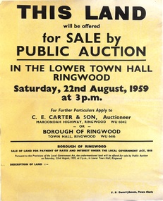 Ringwood and District Historical Society
Poster, Land for Sale by Public Auction, Lower Town Hall, Ringwood - Saturday 22nd August, 1959
Yellow poster and smaller attachment with auction details and summary of four properties offered under Borough of Ringwood instructions for unpaid rates, some with handwritten monetary notations.Lot 49 Patterson Street, East Ringwood (Opp. station). Made Road, Water and E.L. 60'x220' approx. Lot 48 Stoda Street, Heathmont. Water and E.L. 50'x150'. Lot 86 Cnr Heatherbrae & Burwood Avenues, Ringwood. Made roads, Water and E.L. 54'x140' approx. Lot 13 Tagell Road Ringwood. 64'x1130' approx. For further particulars apply to C.E. Carter & Son, Auctioneer, Maroondah Highway, Ringwood (Phone) WU6042, WU6830, or Borough of Ringwood, Town Hall, Ringwood (Phone) WU6616. F.P. Dwerryhouse, Town Clerk. -
 Federation University Historical Collection
Book, Final recommendations Ballarat Study Area Land Conservation Council, Victoria, 1982, 1982
Yellow soft covered report of 95 pages . The contents of the report include: Parks, reference areas, wildlife reserves, water production, hardwood production, softwood production, flora Reserves and Flora and Fauna reserves, bushland reserves, historic area and reserves, rivers and streams, Roadside conservation and Highway parks, Education areas and School Plantations, Lake Reserves, geological reserves, recreation, scenic reserves, agriculture, mineral and stone production, utilities and survey, township land, Uncommitted Land, military training, other reserves and public land. Maps include: The Study area 1: 250 000 Supplementary Mapsland conservation authority, ballarat, endowment plantations, pine plantations, langi ghiran state park, mount buangor state park, enfield state park, ballarat-creswick regional park, rossbridge, black lake, flax mill swamp, dereel lagoon, lake bolac, lake wongan, langi ghiran reservoir, gong gong reservoir, pincotts reservoir, beales reservoir, wilsons reservoir, moorabool reservoir, korweinguboora, korweinguborra reservoir, learmonth bores, sago hill, illabarook reservoir, ballarat water commission, dunneworthy, mount cole, mont lonarch, ben major, waterloo, trawalla, linton, ross creek, canadian, shepherds flat, lal lal, mount doran, raglan, chute, carngham, buninyong, watsons hill, enfield, cape clear, illabrook, rokewood junction, mount warrenheip, nerrina, jubilee, golden stream, australasian deep lead mine, happy valley school, piggoreet, berringa, bulldog, ballarat common, wildlife, water, timber, flora, rivers, geology, agriculture, warrenheip, biodiversity