Showing 232 items
matching railway terminus
-
 Orbost & District Historical Society
black and white photograph, C1914
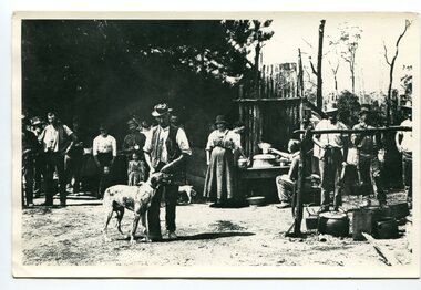
... on Monday 10 April 1916 as the terminus of the Orbost railway line... on Monday 10 April 1916 as the terminus of the Orbost railway line ...This is a photograph of a railway camp, set up to house workers and their families when building the Bairnsdale to Orbost Railway from 1914-1916. The man in the foreground was one of three men killed in an explosion "noon on the railway construction works at Hagen's Cutting, about two miles from Orbost, three men being killed. The victims were John Carroll, con- tractor, his son, Peter Carroll, and John Sullivan, a navvy. The gang had just finished work, and the three stayed behind to draw a blasting charge, which had missed fire yesterday. J. Carroll was using a pick, and it is presumed that the tool struck a percussion cap, and fired the charge. He and Sullivan were killed instantly, Carroll being literally blown to pieces. Fragments of his body and garments were recovered from the surrounding bush, and the main portion of the trunk, with leg attached, was hurled a distance of 200 yards. Peter Carroll was terribly- injured, and he died before medical aid arrived." (from The Mercury Saturday March 114 1914) The Bairnsdale-Orbost railway was opened in 1916 to serve the agricultural and timber industry. Because of the decline in traffic and heavy operating costs, the line was finally closed in August, 1987. Orbost Railway Station was opened on Monday 10 April 1916 as the terminus of the Orbost railway line, and closed in 1987. The station was located on the west side of the Snowy River despite the town of Orbost being on the east side of the river, in order to save on the costs of a bridge over the river, which at the time had highly variable levels. This item is associated with the history of the Orbost-Bairnsdale railway line and therefore reflects the role that the rail line played in the social and economic history of Orbost.A black / white photograph of a campsite. There is a kitchen outside a rough construction. Men and women are standing in the backgroundd with one man and a dog in the foreground.on back - "Man with dog killed in explosion"orbost-railway transport railway-bairnsdale-orbost explosion-railway -
 Orbost & District Historical Society
black and white photograph, 1916
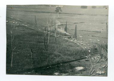
This photograph shows the pile drivers at work in the construction of the viaduct across the Snowy River flats. The Snowy River Floodplain Railway Bridges, two sequential and exceptionally long and low timber railway bridges on the Snowy River floodplain just west of Orbost, were built in 1916, and provided the original terminus point for the Bairnsdale-Orbost railway. The bridges are 770 metres and 183 metres long respectively. The shorter bridge is of uniformly 4.57 metre timber-beam construction, and has a sweeping curve in its deck. The longer bridge has a combination of 4.57 metre and 6.1 metrespans, and two 3.66 metre spans. The bridges are constructed from 'Southern Mahogany', Eucalyptus Botryoides, which grew along the coast east of Bairnsdale. The Snowy floodplain bridges were initially built in the context of an early twentieth-century interest in American-style 'Developmental Railways', designed to open remote areas to closer settlement, even if that meant running at a loss. The line was closed in August 1987. (information from Victorian Heritage Database)This item is associated with the history of the Orbost-Bairnsdale railway line and therefore reflects the role that the rail line played in the social and economic history of Orbost.A black / white photograph of the farming flats at Orbost during the construction of the East Gippsland railway.orbost-railway east-gippsland-railway viaduct-orbost transport railway -
 Orbost & District Historical Society
black and white photographs, Jude, Ray, 1915 - 1969
... 1916 as the terminus of the Orbost railway line, and closed... 1916 as the terminus of the Orbost railway line, and closed ...These photographs relate to the East Gippsland Railway. The Bairnsdale-Orbost railway was opened in 1916 to serve the agricultural and timber industry. Because of the decline in traffic and heavy operating costs, the line was finally closed in August, 1987. Orbost Railway Station was opened on Monday 10 April 1916 as the terminus of the Orbost railway line, and closed in 1987. The station was located on the west side of the Snowy River despite the town of Orbost being on the east side of the river, in order to save on the costs of a bridge over the river, which at the time had highly variable levels. These photographs are associated with the history of the Orbost-Bairnsdale railway line and therefore reflects the role that the rail line played in the social and economic history of Orbost.Seven black / white photographs and one postcard print.3103.1 on back - " Orbost- Snowy River flats viaduct 22-2-1964 ARHS special train Ray Jude photo" 3103.2 - on back -" Orbost Snowy River flats viaduct A.R.H.S. special train 22.2.1969" 3103.3 - on back - " A.R.H.S. special across bridge between Waygara & Nowa Nowa 22-2-1964 3103.4 - on back - " Nowa Nowa Boggy Creek Bridge A.R.H.s. Orbost tour Ray Jude photo" 3103.5 - on back - " Orbost 22-2-1969 SM office & goods shed Ray Jude photo" 3103.6 - on back - " Orbost Railway Yards - 22 February 19369 Ray Jude photo" 3103.7 - on back - " Orbost May 27 -1936 Orbost Rail Station" 3103.8 - on front - caption - Unloading Ballast Orbost line near Newmerella 1915 - J. Sullivan Colin ?orbost-railway east-gippsland-railway bairnsdale-orbost-railway -
 Eltham District Historical Society Inc
Photograph, Bendigo Tramways No. 7 about to arrive at its terminus in North Bendigo near the intersection of Thunder Street and Moray Crescent, January 1972, Jan 1972
The tram line proceeds up to the left just pass Moray Crescent where it terminated alongside the railway line in North Bendigo in 1972Digital TIFF file Scan of 35mm Ilford FP3 black and white negative transparencybendigo, bendigo tramways no. 7, george coop collection, moray crescent, north bendigo, railway crossing, railway line,thunder street, tram -
 Wycheproof & District Historical Society Inc.
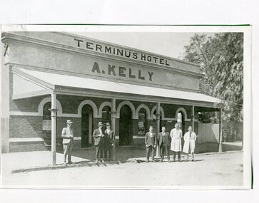
Photograph, Maker Unknown, Terminus Hotel, 1930 (estimated)
The Terminus Hotel opened in January 1884, coinciding with the opening of the railway. The hotel had a close connection with the railway, catering for travellers and relieving railway workers. In December 1903 the original wooden structure burnt to the ground. The hotel was rebuilt in 1904 in much the same form see Record No 00306. Mr Andrew Kelly of Nullawil took over the enterprise circa 1930 giving it a new look in the 'Art Deco' style of the period. Mr Kelly and family ran a successful hotel business for forty years.Copy of a B&W photograph of the Terminus Hotel, situated in Broadway Wycheproof circa 1930s. Of brick construction, featuring arch entrance doorways and windows. A verandah protects the street facade. The architecture represents the 'Art Deco' period.Nonehotel wycheproof broadway, men clothing, art deco 1930s -
 Warrnambool and District Historical Society Inc.
Document, Gauley contracts .1 & .2, C 1878
In 1858 a tramway was constructed to move goods between Warrnambool township and jetty on Lady Bay which was over a mile away The terminus was established on the southern side of Merri Street. and the track went around the edge of Lake Pertobe reserve. Large stores were also built near where the present railway station is situated to hold produce and carriages. These documents relate to contracts between Marion Gauley ,contractor of Warrnambool and the borough of Warrnambool for the operation of horse work with the tramway. John McDermid sadler,and William Stevens farmer of Russell's Creek are acting as surety for the contract.The tramway was an important part of Warrnambool's infrastructure and history and the documents also include names of local people. Of particular interest is the fact that the contract in this case was given to a woman which would have been a little uncommon at that time.001259.1 Pale blue lined paper with red lined outline.Hand written in black pen with names and some other words underlined in red. Two signatures on bottom right with red seal beside each. Witness signature below on left hand side. One page only 001259.2 Pale blue lined paper with red lined outline.Hand written in black pen with names and some other words underlined in red. Two signatures on bottom right with red seal beside each. Witness signature below on left hand side. Of the four pages of the document , only the first page is used. 001259.1 Signed Roady Carew and Moses Daly. Richard Daly is crossed out in the document and Marion Gauley is inserted in greylead. September 1878 001259.2 John McDermid saddler William Stevens, Marion Gauley. Ninth of December 1878. warrnambool, warrnambool tramway, marion gauley, john mcdermid, william stevens -
 Warrnambool and District Historical Society Inc.
Document, Warrnambool Tramways-William Bell, C 1881
In 1858 a tramway was constructed to move goods between Warrnambool township and jetty on Lady Bay which was over a mile away The terminus was established on the southern side of Merri Street. and the track went around the edge of Lake Pertobe reserve. Large stores were also built near where the present railway station is situated to hold produce and carriages.This document is is a surety between John McDermit a saddler of Liebig Street Warrnambool along with Henry Phillips hay and corn dealer of Liebig Street Warrnambool, acting as surety in the amount of fifty pounds to William Bell a contractor to perform horse work for the Warrnambool tramways. for a period of one year, 1881-1882. This contract has a strong historical link to one of Warrnambool's earliest infrastructure projects . It contains the names of local people and provides an insight into the links between people and the types of work they undertook Pale blue lined paper with red lined outline.Hand written in black pen with names and some other words underlined in red. Two signatures on bottom right with red seal beside each. Witness signature below on left hand side. Of the four pages of the document , only the first page is used.Signed John McDermid, Henry Phillips. 1st October 1881.warrnambool,, warrnambool history, warrnambool tramways, william bell contract,, john mcdermid, henry phillips -
 Warrnambool and District Historical Society Inc.
Document, Gallagher, C 1881
In 1858 a tramway was constructed to move goods between Warrnambool township and jetty on Lady Bay which was over a mile away The terminus was established on the southern side of Merri Street. and the track went around the edge of Lake Pertobe reserve. Large stores were also built near where the present railway station is situated to hold produce and carriages. These documents relate to the contract to perform the horse work for the tramway for a period of one year. The horse work involved the transporting of goods by horse drawn tram trucks, all repairs to the tracks , shunting and delivery duties. The tramway operated from 7 am to 6 pm six days a week and a team of six horses was required to perform the work.The tramway was an important part of Warrnambool's infrastructure and history and the documents also include names of local people.001261.1 Pale blue lined paper with red lined outline.Hand written in black pen with names and some other words underlined in red. Two signatures on bottom right with red seal beside each. Witness signature below on left hand side. Of the four pages of the document , only the first page is used. 001261.2 Cream paper lined in blue with heavy black ink writing. A red seal attached beside the tenderer's mark and name. on right side of page. Witness's signature at bottom centre of page.001261.1 James Roberts hay and corn dealer ,Fairy Street Warrnambool, Martin Callaghanfarmer and contractor Raglan Parade Warrnambool. Daniel Gallagher, contractor of Warrnambool. September 1881. 001261.1 Daniel Gallagher .James Roberts Martin Callaghan September 12, 1881.warrnambool, warrnambool history, daniel gallagher, james roberts -
 Warrnambool and District Historical Society Inc.
Document, Conditions of contract for Horse work Tramway Department, C1881
In 1858 a tramway was constructed to move goods between Warrnambool township and jetty on Lady Bay which was over a mile away The terminus was established on the southern side of Merri Street. and the track went around the edge of Lake Pertobe reserve. Large stores were also built near where the present railway station is situated to hold produce and carriages. According to these documents , the horses were required for many different tasks in the operation of the tramways including the moving of freight, removal of sand from the area, shunting of trucks and ballasting and repairing lines when necessary.The contractors had a list of conditions imposed including the provision of six horses of strong working ability and sufficient finances. The contract period was for 1 year and payment was monthly in arrears and hours of operation were from 7 am to 6 pm. These handwritten documents provide an insight into the type of work done in the early days of Warrnambool and the working conditions at the time. Five folded grey paper with red lines around edges. Written in black ink. Only front page of each piece has writing on it. 001262.1 Borough of Warrnambool Tramway Department Specification of Duties Contractor for Horse Work Signed William Bell 28/09/1881 001262.2 Borough of Warrnambool Tramway Department Conditions of contract for Horse Work. Signed Daniel Gallagher 20/09/1881 001262.3 Borough of Warrnambool Tramway Department Specification of Duties Contractor for Horse Work Signed Daniel Gallagher 20/09/1881. 001262.4 Borough of Warrnambool Tramway Department Specification of Duties Contractor for Horse Work Signed Michl Daly 5th September 1878 crossed out 001262.5 Borough of Warrnambool Tramway Department Conditions of contract for Horse Work Signed William Bell 28/09/1881warrnambool, warrnambool tramway, horse work, tramway contract -
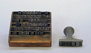 Orbost & District Historical Society
stamp holder and numbers, Victorian Government Railways, c. 1930s- 1980s
... 1916 as the terminus of the Orbost railway line, and closed... 1916 as the terminus of the Orbost railway line, and closed ...Used on the Orbost-Bairnsdale railway line which closed in 1987. The Bairnsdale-Orbost railway was opened in 1916 to serve the agricultural and timber industry. Because of the decline in traffic and heavy operating costs, the line was finally closed in August, 1987. Orbost Railway Station was opened on Monday 10 April 1916 as the terminus of the Orbost railway line, and closed in 1987. The station was located on the west side of the Snowy River despite the town of Orbost being on the east side of the river, in order to save on the costs of a bridge over the river, which at the time had highly variable levels This item is associated with the history of the Orbost-Bairnsdale railway line and therefore reflects the role that the rail line played in the social and economic history of Orbost.A stamp holder made of aluminium into which numbers and possibly letters can be inserted. Also a square shallow wooden box containing numbers which are used with the stamp. The numbers appear to be made of rubber.possibly V G R railway-history orbost-bairnsdale-railway -
 Orbost & District Historical Society
railways envelope, Victorian Railways, c. 1970s-1980s
... Railway Station was opened on Monday 10 April 1916 as the terminus... as the terminus of the Orbost railway line, and closed in 1987 ...Used at Orbost railway station for the consignment of goods/freight, in this case, timber to Westall. The Bairnsdale-Orbost railway was opened in 1916 to serve the agricultural and timber industry. Because of the decline in traffic and heavy operating costs, the line was finally closed in August, 1987. Orbost Railway Station was opened on Monday 10 April 1916 as the terminus of the Orbost railway line, and closed in 1987. The station was located on the west side of the Snowy River despite the town of Orbost being on the east side of the river, in order to save on the costs of a bridge over the river, which at the time had highly variable levels. This item is associated with the history of the Orbost-Bairnsdale railway line and therefore reflects the role that the rail line played in the social and economic history of Orbost.An unused brown/buff coloured goods/freight consignment envelope used by Victorian Railways, this one for timber from Orbost to Westall. 2498-78 VICTORIAN RAILWAYS From ORBOST to WESTALL Contents TIMBER railway-history orbost-bairnsdale-railway -
 Orbost & District Historical Society
Victorian Railways pencil, Victorian Railways, c. 1960s-1980s
... on Monday 10 April 1916 as the terminus of the Orbost railway line... on Monday 10 April 1916 as the terminus of the Orbost railway line ...Used by Victorian Railways at stations on the Orbost-Bairnsdale line. The Bairnsdale-Orbost railway was opened in 1916 to serve the agricultural and timber industry. Because of the decline in traffic and heavy operating costs, the line was finally closed in August, 1987. Orbost Railway Station was opened on Monday 10 April 1916 as the terminus of the Orbost railway line, and closed in 1987. The station was located on the west side of the Snowy River despite the town of Orbost being on the east side of the river, in order to save on the costs of a bridge over the river, which at the time had highly variable levels. This item is associated with the history of the Orbost-Bairnsdale railway line and therefore reflects the role that the rail line played in the social and economic history of Orbost.A thick, hexagonal shaped pencil made of wood, painted dark blue, containing blue graphite marker.VICTORIA RAILWAYS written in gold lettering Emperor, Made in Australia railway-history victorian-railways orbost-bairnsdale-railway -
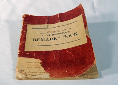 Orbost & District Historical Society
Victorian Railways remarks book, Victorian Railways, c. 1940s
... Used at Orbost Railway Station, possibly by the Station... gippsland Used at Orbost Railway Station, possibly by the Station ...Used at Orbost Railway Station, possibly by the Station Master, between 1944 and 1984. The Bairnsdale-Orbost railway was opened in 1916 to serve the agricultural and timber industry. Because of the decline in traffic and heavy operating costs, the line was finally closed in August, 1987. Orbost Railway Station was opened on Monday 10 April 1916 as the terminus of the Orbost railway line, and closed in 1987. The station was located on the west side of the Snowy River despite the town of Orbost being on the east side of the river, in order to save on the costs of a bridge over the river, which at the time had highly variable levels. This item is associated with the history of the Orbost-Bairnsdale railway line and therefore reflects the role that the rail line played in the social and economic history of Orbost.Book with a red cover. On the front cover VICTORIAN RAILWAYS Audit Inspectors Remarks Book, Orbost. Inside are numbered and lined pages with hand written information dating from 28/3/1944-13/8/1984, dated and signed by various station masters. Cover has a section missing from the bottom left.VICTORIAN RAILWAYS Audit Inspectors Remarks Book, Orbost.railway-history orbost-bairnsdale-railway -
 Ringwood and District Historical Society
Pamphlet, G.A. Green, Auction Sale Brochure - Garden Farms Estate, Ringwood, Victoria - 1919, 1919
Multi-fold brochure advertising public auction of one-acre, 2-acre, 5-acre and 8-acre allotments in Ringwood and Bayswater on Saturday 12th April, 1919. Brochure includes terms of sale, description of subdivision features and local facilities, and photographic images of the area.Subdivison includes Canterbury Road Heathmont, Armstrong Road Heathmont, Armstrong Road Bayswater, Bungalook Road Heathmont, Bungalook Road Bayswater, and Orchard Road Bayswater. Road shown as Bayswater Road to Bayswater became Mountain Highway Bayswater. Vendor: H.E.B.Armstrong, Auctioneers: Coghill & Haughton, 79 Swanston Street Melbourne, Telephone Central 2793, in conjunction with J.B. McAlpin, Ringwood, Opposite Station, Telephone Ringwood 7. (Map) Woodcock & McCormack, Civil Engineers Architects & Surveyors, 430 Little Collins Street, Melbourne, Phone 3241 Central. MOST OF THE MONEY COMES OUT OF THE LAND. And more money can be obtained from anb acre of fruit than from an acre of any other produce. But you do not have to grow fruit on Garden Farms Estate. You can go in for - Outer Suburban Home - Market Garden - Orchard - Pig Raising - Poultry Farm - Small Dairy Farm - Small Fruits - Floral Culture - Scent and Bee Farm - Or just for a Week-end Home. RINGWOOD - THE PLACE TO LIVE. The Beautiful Ringwood District has so many natural attractions, that half a Land Agent's work is done in just showing a prospective buyer round and about. Ringwood has a pull of its own that attracts folk, proved beyond doubt by its rapid development within the last decade (spite the war). First, it is high and healthy, picturesque and undulating, convenient of access, sufficiently close to the Metropolis for City and Business folk to live at Ringwood. Its development is solid, because most of its people are industrious husbandmen, real producers, who have turned idle hills into smiling gardens. These are the kind of real people to live amongst; ones who wear out their spades. The rapidly-developing town has excellent Stores, Trade and Repair Shops Churches, Banks, Telephone Exchange, Weekly General Market, Cool Stores, and good Private and State Schools, etc.; is Electrically lit, has Metropolitan Water Supply, and generally provides so that practically all shopping can be done locally. WHY RINGWOOD MUST GROW. Ringwood is a great centre and must be a greater. Two rapidly-developing railways junction here. The passengers from Ringwood Station cityward, in one year, number 250,000. Ringwood will be the terminus of the Outer Suburban Electric Eastern Railway. Its natural boundaries are the River Yarra on the North, Dandenong Creek on the South, the popular town of Croydon on the East, and the suburb of Mitcham on the West. This is a large territory that is steadily being converted from intense culture, and then it might be called (as regards its gardens) "The Devon Territory of Victoria." ARMSTRONG ROAD. This new road traverses Garden Farms Estate from its northern boundary on the main Canterbury Road, across Dandenong Creek, to its southern boundary on the main Bayswater Road, and will provide a long-desired additional link of communication between Bayswater and Ringwood. The 1-acre building sites on Bayswater Road are within 8 minutes' walk of the Bayswater Railway Station, and the Canterbury Road frontages are only 1-1/2 miles from Ringwood Station, and 1/2 mile from the Railway Station site of Canterbury Road; therefore, the whole Estate is easy of access and there should be a large demand for land so favourably placed. (Image) Cultivation Field - Potatoes on Lot 28 (Image) Picture of Bayswater Creek Flats. (Image) View from "Korumbeen" where Mr. Armstrong lived on Garden Farms Estate. Estate outlined in white ring. (Image) Site of New Bridge over Dandenong Creek. (Image) On one of the timbered lots adjoining railway. (Image) This Dandenong Creek traveres the Estate. (Image) Main Fern Tree Gully Line bisects the Estate. -
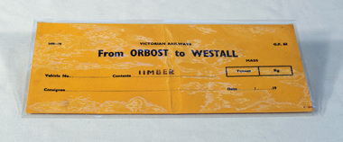
 Orbost & District Historical Society
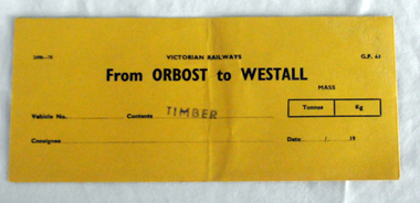
railways envelope, C 1980's
... on Monday 10 April 1916 as the terminus of the Orbost railway line... on Monday 10 April 1916 as the terminus of the Orbost railway line ...This item was used by Victorian Railways 1970's/1980's. It was used at Orbost Railway Station for the consignment of timber from Orbost to Westall.. Westall was a major timber-receiving depot near Dandenong, Victoria. Westall railway station is located on the Pakenham and Cranbourne lines in Victoria, Australia. It serves the south-eastern Melbourne suburb of Clayton South, opening on 6 February 1951. Westall station was opened as a workers only platform on 16 October 1954. It was provided for the adjacent Martin & King railway coachbuilding factory. The station was opened to the public on 1 June 1959 when all trains on the line began stopping there. The Bairnsdale-Orbost railway was opened in 1916 to serve the agricultural and timber industry. Because of the decline in traffic and heavy operating costs, the line was finally closed in August, 1987. Orbost Railway Station was opened on Monday 10 April 1916 as the terminus of the Orbost railway line, and closed in 1987. The station was located on the west side of the Snowy River despite the town of Orbost being on the east side of the river, in order to save on the costs of a bridge over the river, which at the time had highly variable levels. This item is associated with the history of the Orbost-Bairnsdale railway line and therefore reflects the role that the rail line played in the social and economic history of Orbost.An unused brown/buff coloured goods/freight consignment envelope used by Victorian Railways, this one for timber from Orbost to Westall. It is DL size.2497-78 VICTORIAN RAILWAYS G.F 63 From ORBOST to WESTALL MASS Tonnes kg Vehicle No Contents TIMBER Consignee Date orbost-bairnsdale-railway westall -
 Orbost & District Historical Society
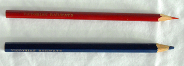
pencils, 1960's
... Railway Station was opened on Monday 10 April 1916 as the terminus... Railway Station was opened on Monday 10 April 1916 as the terminus ...These pencils were supplied to the Orbost railway Station office to be used for clerical work. They were used by Victor Smithers who was the Assistant Station Master at Orbost from 1957 - late 1960's. He was also a reliever until the 1970's after which he returned to Ormond Station on the Frankston line where he worked until his death in 1979. The Bairnsdale-Orbost railway was opened in 1916 to serve the agricultural and timber industry. Because of the decline in traffic and heavy operating costs, the line was finally closed in August, 1987. Orbost Railway Station was opened on Monday 10 April 1916 as the terminus of the Orbost railway line, and closed in 1987. The station was located on the west side of the Snowy River despite the town of Orbost being on the east side of the river, in order to save on the costs of a bridge over the river, which at the time had highly variable levels. This item is associated with the history of the Orbost-Bairnsdale railway line and therefore reflects the role that the rail line played in the social and economic history of Orbost.Two coloured pencils. 2580.1 is a hexagonal blue pencil and has "Wolff's Emperor MADE IN AUSTRALIA". 2580.2 is a round red pencil with "Wolff's Fintorex MADE IN AUSTRALIA coloured copying". Both have "VICTORIAN RAILWAYS" marked in gold lettering on the sides. orbost-railway-station smithers-victor -
 Orbost & District Historical Society
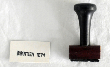
stamp, C 1960's
... 1916 as the terminus of the Orbost railway line, and closed... 1916 as the terminus of the Orbost railway line, and closed ...This stamp was used at the Orbost Railway Station. The Bairnsdale-Orbost railway was opened in 1916 to serve the agricultural and timber industry. Because of the decline in traffic and heavy operating costs, the line was finally closed in August, 1987. Orbost Railway Station was opened on Monday 10 April 1916 as the terminus of the Orbost railway line, and closed in 1987. The station was located on the west side of the Snowy River despite the town of Orbost being on the east side of the river, in order to save on the costs of a bridge over the river, which at the time had highly variable levels This item is associated with the history of the Orbost-Bairnsdale railway line and therefore reflects the role that the rail line played in the social and economic history of Orbost.A stamp with a black plastic handle. The bottom is wood and the stamp rubber. It has "BRUTHEN 1879" on it."BRUTHEN 1879"orbost-railway-station -
 Orbost & District Historical Society
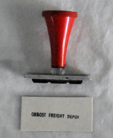
stamp, 1970's
... as the terminus of the Orbost railway line, and closed in 1987... as the terminus of the Orbost railway line, and closed in 1987 ...This stamp was used at the Orbost Railway Station. The Bairnsdale-Orbost railway was opened in 1916 to serve the agricultural and timber industry. Because of the decline in traffic and heavy operating costs, the line was finally closed in August, 1987. Orbost Railway Station was opened on Monday 10 April 1916 as the terminus of the Orbost railway line, and closed in 1987. The station was located on the west side of the Snowy River despite the town of Orbost being on the east side of the river, in order to save on the costs of a bridge over the river, which at the time had highly variable levels, This item is associated with the history of the Orbost-Bairnsdale railway line and therefore reflects the role that the rail line played in the social and economic history of Orbost.A stamp with a red plastic handle and a white stamping face - "ORBOST FREIGHT DEPOT".VUESTAMP AUSTRALIAorbost-railway -
 Orbost & District Historical Society
handsaw, C mid 20th century
... 1916 as the terminus of the Orbost railway line, and closed... 1916 as the terminus of the Orbost railway line, and closed ...The Bairnsdale-Orbost railway was opened in 1916 to serve the agricultural and timber industry. Because of the decline in traffic and heavy operating costs, the line was finally closed in August, 1987. Orbost Railway Station was opened on Monday 10 April 1916 as the terminus of the Orbost railway line, and closed in 1987. The station was located on the west side of the Snowy River despite the town of Orbost being on the east side of the river, in order to save on the costs of a bridge over the river, which at the time had highly variable levels. This item is associated with the history of the Orbost-Bairnsdale railway line and therefore reflects the role that the rail line played in the social and economic history of Orbost.A handsaw with a wooden handle and a metal blade with serrated teeth which continue around the nose of the blade.Marked V an upward pointing arrow Rsaw carpentry orbost-bairnsdale-railway orbost-railway-station -
 Orbost & District Historical Society
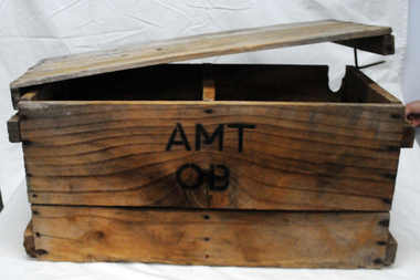
box, first half 20th century
... by rail - C 1940's -1950's. The Bairnsdale-Orbost railway... by rail - C 1940's -1950's. The Bairnsdale-Orbost railway ...This box was used by Lindsay Thomson's mother, Annie M. Thomson for the transport of hen eggs from Orbost to Melbourne by rail - C 1940's -1950's. The Bairnsdale-Orbost railway was opened in 1916 to serve the agricultural and timber industry. Because of the decline in traffic and heavy operating costs, the line was finally closed in August, 1987. Orbost Railway Station was opened on Monday 10 April 1916 as the terminus of the Orbost railway line, and closed in 1987. The station was located on the west side of the Snowy River despite the town of Orbost being on the east side of the river, in order to save on the costs of a bridge over the river, which at the time had highly variable levels. This item is associated with the history of the Orbost-Bairnsdale railway line and therefore reflects the role that the rail line played in the social and economic history of Orbost. A wooden box with two inside sections and a wooden lid which is secured on both ends by large nails/spikes which are fitted into a groove and are then turned. On front and back in black stencilled letters A M T O B container railway eggs -
 Orbost & District Historical Society
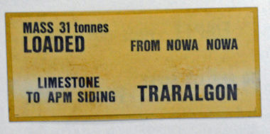
label / sign, 1970's -1980's
... as the terminus of the Orbost railway line, and closed in 1987... as the terminus of the Orbost railway line, and closed in 1987 ...This item was used by Victorian Railways in 1980's. It was inserted onto the side of railway freight wagons. The Bairnsdale-Orbost railway was opened in 1916 to serve the agricultural and timber industry. Because of the decline in traffic and heavy operating costs, the line was finally closed in August, 1987. Orbost Railway Station was opened on Monday 10 April 1916 as the terminus of the Orbost railway line, and closed in 1987. The station was located on the west side of the Snowy River despite the town of Orbost being on the east side of the river, in order to save on the costs of a bridge over the river, which at the time had highly variable levels This item is associated with the history of the Orbost-Bairnsdale railway line and therefore reflects the role that the rail line played in the social and economic history of Orbost.A double -sided rectangular shaped label / sign, heavily laminated.Black print on light brown background. On one side : "MASS 31 tonnes LOADED; FROM NOWA NOWA; LIMESTONE TO APM SIDING; TRARALGON". On reverse : "EMPTY FROM TRARALGON; TO APM LIMESTONE SIDING ; NOWA NOWA".freight orbost-bairnsdale-railway -
 Orbost & District Historical Society
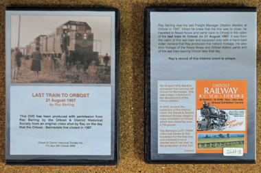
D.V.D. s, Last Train to Orbost, 21.8.1987
... as the terminus of the Orbost railway line, and closed in 1987... as the terminus of the Orbost railway line, and closed in 1987 ...These are copies of an original video shot by Ray Barling on the day that the Orbost-Bairnsdale line closed in 1987. He used a hand-held video camera from his cabin on the train, The video was shown at the 2016 Centenary Exhibition in Orbost. The Bairnsdale-Orbost railway was opened in 1916 to serve the agricultural and timber industry. Because of the decline in traffic and heavy operating costs, the line was finally closed in August, 1987. Orbost Railway Station was opened on Monday 10 April 1916 as the terminus of the Orbost railway line, and closed in 1987. The station was located on the west side of the Snowy River despite the town of Orbost being on the east side of the river, in order to save on the costs of a bridge over the river, which at the time had highly variable levels. This item is associated with the history of the Orbost-Bairnsdale railway line and therefore reflects the role that the rail line played in the social and economic history of Orbost. On April 10 1916, the first scheduled train service left Orbost for Bairnsdale. The Bairnsdale-Orbost railway was opened to serve the agricultural and timber industry. Because of the decline in traffic and heavy operating costs, the line was finally closed in August, 1987. Orbost Railway Station was opened on Monday 10 April 1916 as the terminus of the Orbost railway line, and closed in 1987. The station was located on the west side of the Snowy River despite the town of Orbost being on the east side of the river, in order to save on the costs of a bridge over the river, which at the time had highly variable levels, The video was shown for the first time at the Centenary Exhibition held in Orbost, by the Orbost & District Historical Society, t created much interest leading to the production of the videos.Two copies of a D.V.D. titled"Last Train To Orbost 21 August 1987". The cover is a photo of the last train.rail-closure orbost-bairnsdale-railway -
 Glen Eira Historical Society
Document - LAND SUBDIVISIONS 1880-1938
This file contains various subdivisions’ advertising flyers and cards. 1/Advertising announcement for auction sale of land (15 lots) at Glenhuntly Tram Terminus, to be held on 29/03/1924. Verso is map of the area (21.5cm x 29cm) 2/Advertising announcement for Trustees’ Auction sale of corner shop sites at Caulfield South near Glenhuntly Road and Hawthorn Roads, 15/11/1927 (21cm x 31cm) 3/Advertising pamphlet (A3) for auction of Cantala Estate, East St. Kilda (32 allotments), between Dandenong, Waiora, and Alma Roads, 21/05/1938 (15.5cm x 28.5cm) 4/Seven advertising postcards relating to auctions of land in Caulfield and Elsternwick. Only one (10 December 1881) with a year on it. (Each 13.5cm x 9cm) 5/Four more advertising postcards relating to auctions of land in Caulfield. One is dated 31/11/1880(?); another 09/02/1905. A third has no date. A fourth postcard is a map of allotments between Orrong, Kooyong, Seymour and Alison Roads, Caulfield, no date (each 13.5cm x 9cm) 6/Large advertising poster (41cm x 52.5cm) for ‘Carnegie Land Sale’ auction of the Egan Estate (near Carnegie Railway Station) on 12 April, no year given, but appears to be circa1900 7/‘Riddell Estate – Plan of Subdivision – Parish of Prahran’ mounted map, no date, probably c. 1900 (16cm x 21cm)auctions, house auctions, land subdivision, land development, subdivisions, caulfield, land subdivisions, east st. kilda, glenhuntly, carnegie, map, ‘new glenhuntly tram terminus estate’, ‘cantala estate’, ‘strathnaver estate’, ‘range estate’, ‘egan estate’, ‘riddell estate’ -
 Bendigo Historical Society Inc.
Photograph - BASIL MILLER COLLECTION: TRAM - BENDIGO TRAMWAYS
... No. 11 tram departing Nt. Bendigo terminus, steam... terminus, steam on railway line on RH side of tram. Photograph ...No. 11 tram departing Nt. Bendigo terminus, steam on railway line on RH side of tram.person, individual, basil miller -
 Bendigo Historical Society Inc.
Photograph - TED BEATTIE COLLECTION: PHOTOGRAPHS, Pre 1980s
Four coloured photographs of Bendigo. a. Photo taken from the town hall tower looking over Bull Street towards Camp Hill. b. Conservatory and Gardens looking towards Bridge Street. c. Tram at North Bendigo Terminus with Steam Train on Railway Crossing. d. Fountain at Charing Cross looking towards Rosalind Park -
Port Melbourne Historical & Preservation Society
Photograph - Port Melbourne light rail terminus, 2002
Further updates from Ron Laing's photograph collection of Port Melbourne.(4) colour photographs of the Port Melbourne tram terminus showing its location in relation to the old Port Melbourne railway station, now a medical centre.transport - tramways, ron laing -
 Tramway Heritage Centre
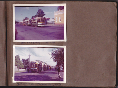
Photograph Album (part of), Ray Pearson's Photo Album - Trams of Victorian Railways, Ballarat, Bendigo, Geelong
Page 9 of Ray Pearson's Photo Album. Brown card page with two photographs (landscape format) placed on page using clear plastic photo corners. Both photographs depict trams around Bendigo. Hand written inscriptions are located beneath each photo. The brown paper has some minor damage to top and bottom right corners from what appears to be the removal of adhesive photo corners.Hand written inscription in biro - Between top and bottom photograph: GOLDEN SQUARE 4/3/72 At base of page: QUARRY HILL TERMINUS 4/3/72 -
 Bendigo Historical Society Inc.
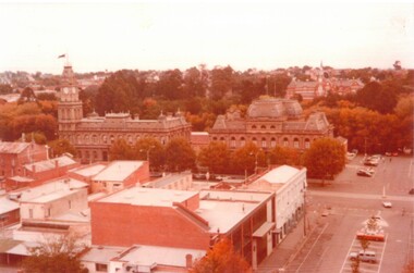
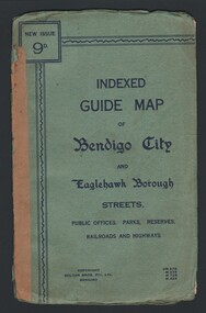
Map - INDEXED GUIDE MAP OF BENDIGO CITY & EAGLEHAWK BOROUGH, Early to mid 1920's
Map. Indexed Guide Map of Bendigo City & Eaglehawk Borough. Folded map contained within blue booklet. Booklet is light blue printed with dark blue ink. Copyright Bolton Bros. Pty. Ltd. Bendigo. Printed on front. Map shows the location of Sailors Gully, Peg Leg Gully, California Gully, Long Gully, Eaglehawk Creek, Bendigo Creek, Ironbark Creek. Shows location of Showgrounds between Park St, Baxter Street, Barnard St and Bridge Lane. Shows location of Golden Square Railway Station between Panton St and Allingham St. Shows what is now known as Creek St. Nth & Sth as Clark St Nth & Sth. Also shows Tramway Terminus along Carpenter St and Golden Square Tram Terminus on High St, Golden Square. Map has a street index and an index for Public Offices, Parks and Reserves.map, bendigo, township, indexed guide map of bendigo city and eaglehawk borough -
 Bendigo Historical Society Inc.
Document - GOLD RUSHES AROUND BENDIGO
... a bell and shouting to all that the tram terminus at the Railway... and shouting to all that the tram terminus at the Railway Station ...Typed and hand written notes on 'Gold Rushes around Bendigo', Eaglehawk Police Station, Bells In and Around Bendigo, Bendigo Historical Society Newsletter, Mr Henry Jones - Gold Buyer, and Sir John Quick. Gold Rushes Around Bendigo tells of some gold finds around Bendigo. Eaglehawk Police Station tells of the Building of the Log Lockups at Eaglehawk and White Hills and where the idea came from. Also the cost of building and source of logs. Bells In and Around Bendigo tell of a tram employee ringing a bell and shouting to all that the tram terminus at the Railway Station was discontinued. When this was sufficiently known the bell went to the Bridge Street Methodist Church. The BHS Newsletter mentions business men's names and connection with their trade. Mr Henry jones - Gold Buyer mentions where his office was and that you could buy gold and money could be exchanged as well. Sir John Quick page tells of the early life of Sir John Quick and his self-education, of the A. N. A. opening in Victoria.document, names of bendigo pioneers, bendigo goldfields, gold rushes around bendigo, caltex oil co, matt egan, thos fleck, knight's brick kiln, water commission, work shops, l king, r king, j mumberry, a kelly, 'auld dart', robert fallon, mrs jane stinton, joch, vol 1 gold nuggets literary society files (manuscript written 1852-1882.), john o'c hattam, eaglehawk police station, mr w perry, log lock-ups, john fry, charles fry, bendigo advertiser 30/3/1949, alex h stone, bendigo advertiser 20/41949, milburn's coffee palace, shell service station, bridge street methodist church, mr don hargreaves, bendigo historical society newsletter, mr buzza, mr ankle, mr foote, mr scales, mr bull, mr mutton, mr body, mr satori, mr tankard, mr punch, mr snowball, mr sweet, mr goody, mr pallett, mr frame, mr henry jones, bendigo advertiser centenary of bendigo supplement 1951, sir john quick, a w llewelyn, australian natives association, friendly society, virginia battery, commonwealth parliament, federation league, mr alfred deakin, mr d'esterre taylor, mr peacock, mr barret, mr george reid, corowa conference 1893, poet gay, bendigo cemetery, centenary history ana 1871-1971, john e menadue -
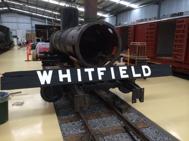 Puffing Billy Railway
Station Sign, whitfeild Station sign
... Historic - Victorian Railways Station sign used... was the small terminus for the Whitfield railway line The station had ...Historic - Victorian Railways Station sign used at Whitfield Station Whitfield Station The terminus of the line. Whitfield was the most distant narrow gauge station from Melbourne Opened 1899 Closed 1953 Whitfield was the small terminus for the Whitfield railway line The station had a moderately long passenger platform, small goods yard, goods shed, ticket office and locomotive shed. Platforms 1 Tracks 3 Historic - Victorian Railways Station sign used at Whitfield StationStation Sign - Whitfield large black wooden backing board with white letteringWhitfieldpuffing billy, victorian railways, station sign, whitfield