Showing 213 items
matching ramp
-
 Moorabbin Air Museum
Booklet (Item) - Ansett Technical Training Centre Ramp Safety And Ground Equipment
-
Moorabbin Air Museum
Manual (Item) - Collins Avionics 475D-1 DME Ramp Test Set
-
 Ringwood and District Historical Society
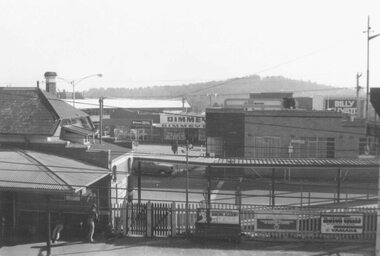
Photograph, Maroondah Highway Central, Ringwood. Pedestrian ramp at railway station, 1976
Black and white photograph.Date written on back of photograph: "Mid 1976". -
 Ringwood and District Historical Society
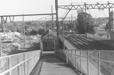
Photograph, Ringwood Railway Station - ramp leading down to No. 2 platform looking west, combined with the station car park bordering Station St
Black and White PhotographDesciption of location on rear of photo -
Lakes Entrance Historical Society
Book, Clark, Vincent and Anderson Tsari, Ocean Access Boat Ramp Bastion Point Mallacoota, 2005
Cultural Heritage Investigation. Report to East Gippsland Shire Council. Cultural Heritage Investigation.waterways, township -
 Ringwood and District Historical Society
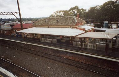
Photograph, Ringwood Railway Precinct in 2009, showing heritage Station building on platform no. 1, taken from foot ramp on opposite platform
-
 Ringwood and District Historical Society
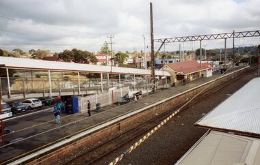
Photograph, Ringwood Railway Precinct circa 2008, showing the heritage building and ramp on platforms 2 & 3
-
 Ringwood and District Historical Society
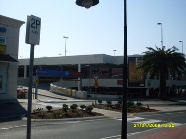
Photograph, Looking along Eastland access road looking northeast, on 21 April 2009. Showing entrance ramp to Eastland multi-level carpark
Ron Brons photographic study of Ringwood. -
 Stawell Historical Society Inc
Photograph, Magdala Cum Moonlight Gold Mining company and Workers c1890
Magdala cum Moonlight Mine. Group of mine workers c1890 against the background of the mine. The wooden ramp built on trestles was used by horse drawn drays to deliver the Quartz for treatment in the cyanide vats.Dark photo of mine workers lined up in front of ore ramp. Horses and drays would go up the ramp to dump the crushed sand into the cyanide vats. Building is on right."Elite" Studio Co. Melbournestawell gold mining -
 Lakes Entrance Historical Society
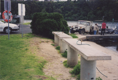
Photograph - North Arm near Apex Park Lakes Entrance Victoria, Tidy Town Committee, 1995c
fish cleaning benches at North Arm boat ramp near Apex Park Lakes Entrance VictoriaColour photograph showing fish cleaning benches at North Arm boat ramp near Apex Park Lakes Entrance Victoriaclubs, fishing, recreation, sports, harbour facilities, recreation facilities -
 Port of Echuca
Colour Photograph, 04/03/1983
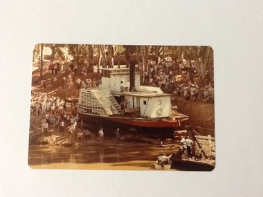
This coloured photograph shows the re-floating of the P. S. Adelaide on a soil ramp, being encouraged (rear entry) down the temporary slipway onto the river. The temporary slipway is clearly visible with a workman (possibly Kevin Hutchinson) standing at thelast log as the boat nears the waters' edge. A winching float and an outboard motor boat are at the right. Spectators line the banks of the ramp. Part of a photo sequence no.P000041; P000045; P000046; P000047; P000048 of P. S. Adelaide re-floating.The re-floating of the P. S. Adelaide was a Significant community social event evident by the number of spectators in the photograph. The community had invested a great deal of time and money into re-floating the paddlesteamer. The newspaper covered the event in detail with a number of action shots as the boat made its rear entry from the temporary slipway onto the river. Part of a photo sequence no.P000041; P000045; P000046; P000047; P000048 of P. S. Adelaide re-floating.Colour photograph of the P. S. Adelaide on a soil ramp, being encouraged (rear entry) onto the river. A winching float and an outboard motor boat are at the right front. Spectators line the banks of the ramp. Temporary slipway constructed of logs is clearly visible before the boat enters the water. -
 Kew Historical Society Inc
Photograph - Flooding of the Yarra River in North Kew, 1934
North Kew, now divided between Kew and Kew East, bordered the Yarra River. As such, it was a region subject to flooding in the Yarra Valley. Development beyond this point (ie Kellett Grove) was limited by the City of Kew's planning regulations. Prior to urban development, the area since European settlement and the first land sales in the district in the 1840s, had been used for dairy farming. Small sepia snapshot taken from the river ramp of a house at 8 Kellett Grove, in what was then known as North Kew. The point of view is from a backyard looking towards Fairfield. Beyond the fence line are two almost submerged houses. A number of people are in a motor driven boat midstream. Fairfield at this period, (ie 1934) was noted for its limited river side development. Verso: 2/12/34 / TAKEN FROM OUR RAMPyarra river -- north kew, floods -- yarra valley, floods -- north kew, floods -- 1929, floods -- 1934, natural disasters -- kew -
 Lakes Entrance Historical Society
Photograph - Fishing Club Lakes Entrance, Lakes Post Newspaper, 1995c
Fishing Club building entrance Lakes Entrance Victoria. Also black and white photograph of toilet block for Fishing Club boat ramp 1992 July number 04058.1 size 2.5 x 3 cm. Also black and white photograph of toilet block for Fishing Club boat ramp 1992 July number 04058.1 size 2.5 x 3 cmBlack and white photograph of Fishing Club building entrance Lakes Entrance Victoria. Also black and white photograph of toilet block for Fishing Club boat ramp 1992 July number 04058.1 size 2.5 x 3 cmrecreation, sports, fishing, clubs -
 Lakes Entrance Historical Society
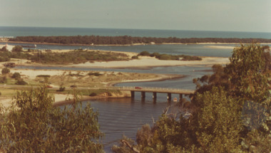
Photograph - North Arm Bridge, road to Bullock Island, build up of sand spit later site for Fishing Club and boat ramp, Lakes Entrance Victoria, G W Holding, 1/04/1979 12:00:00 AM
North Arm Bridge, road to Bullock Island, build up of sand spit later site for Fishing Club and boat ramp, Lakes Entrance Victoria. Taken during the King of the Straits eventColour photograph taken from Kalimna Heights showing North Arm Bridge, road to Bullock Island, build up of sand spit later site for Fishing Club and boat ramp, Lakes Entrance Victoria waterways, islands, bridges -
Glenelg Shire Council Cultural Collection
Photograph - Photograph - Ramp to load sheep onto ship secured into position, n.d
Port of Portland Authority archivesFront: (no inscriptions) Back: (no inscriptions) -
 Sunbury Family History and Heritage Society Inc.
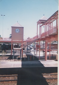
Photograph, Shannon Richards, Sunbury Station, March 2001
In 2000 major renovation works were carried out on the Sunbury Bendigo Rail line to accommodate new and larger carriages which were going to replace older trains. Major work at Sunbury included extending the platforms and replacing an old wooden pedestrian bridge with a larger one the included a series of ramps and a clock tower as well as a new pedestrian bridge.A non-digital coloured photograph of a series of ramps over railway tracks with a clock tower. The photograph was an entry in the Junior section of a photographic competition organised by the Sunbury & District Heritage Association in March 2001. sunbury railway station, sunbury, railways, bendigo rail line -
 Lakes Entrance Historical Society
Photograph - Bullock Island Lakes Entrance, Holding M, 2000 c
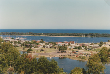
photographs showing view of town from across North Arm from western boat ramp east to Orme Street continued from 04216 number 04216.1 and 04216.2 size 10 x 15 cm|. Colour photograph of town from Kalimna Heights showing Hill 60 on Hummocks taken 1975 c printed from slide number 04216.3Colour photograph of western end of town taken from Kalimna Heights showing cars parked near western boat ramp and North Arm, hummocks and Bass Strait in distance, Lakes Entrance Victorialookouts, topography, buildings, islands -
 St Kilda Historical Society
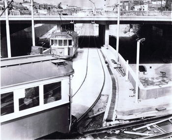
Photograph, Wellington St bypass, c. 1968
picture shows ramp from St Kilda Road to by-pass road filed 22.10.68black and white photographAge photo V18369 (titled 22.10.68). Trams using Wellington St by-pass for first time. Picture shows ramp from St Kilda Rd to by-pass road. Copyright. This photo may not be reproduced without permission in writing from the editorof "The Age". 250 Spencer Street, Melbourne and 39/41 York Street, Sydney. -
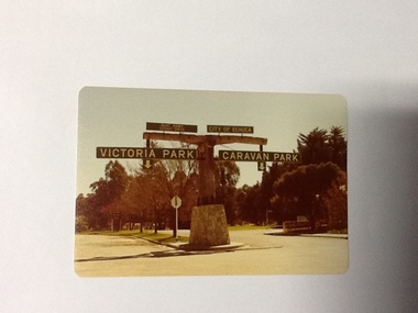 Port of Echuca
Colour Photograph, Approx.1979
In 1869 the Council moved to name this park "Victoria Park. The cricket pitch construction began in 1873 and major improvements to the ground were undertaken in 1881. It is still the primary sporting ground in Echuca, offering AFL football oval, cricket pitch and nets, athletics and entry to the Echuca boat ramp and the natural bush land of the scenic drive. It also houses Echuca Council caravan park. The signage in this photograph is no longer there and the enterance to the caravan park has moved.This area of Echuca has historically been a major recreational area for the town. Being the primary sporting ground since its establishment in 1869., the area has a number of sporting and recreational facilities for the people of Campaspe Shire, from natural bush walks in and along the Murray river to more formal facilities such as AFL football ground, firefighting training area, netball courts, cricket pitch and nets, and grass tennis courts. Colour photograph (post-card size) of directory signs to entrance of Victoria Park, Echuca taken facing north. Two driveways are shown, to the east "Caravan Park" and to the west , "Victoria Park", "Boat ramp", " Scenic drive"Printed in black on the reverse:"this paper manufactured by Kodak"echuca, port of, echuca council caravan park, victoria park, echuca, echuca-tourist attraction -
Glenelg Shire Council Cultural Collection
Photograph - Photograph - Ramp to load sheep onto ship, n.d
Port of Portland Authority archivesFront: (no inscriptions) Back: (no inscriptions) -
Glenelg Shire Council Cultural Collection
Photograph - Photograph - Ramp to load sheep onto ship, n.d
Port of Portland Authority archivesFront: (no inscriptions) Back: (no inscriptions) -
Glenelg Shire Council Cultural Collection
Photograph - Bromide Photograph - Concrete ramp next to building, n.d
Port of Portland Authority Archivesport of portland archives -
Phillip Island and District Historical Society Inc.
Photograph
Vehicular Ferry SS "Killara". Also took stock and passengers between Stony Point, French Island and Cowes from 1933 - 1942.Close up of vehicle on ramps being unloaded.local history, photography, photographs, slides, film, steam ships, transport, black & white photograph, transport, steam ships -
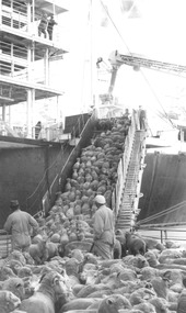 Glenelg Shire Council Cultural Collection
Photograph - Photograph - Sheep being loaded onto live transport ship, n.d
Port of Portland Authority archivesFront: (no inscriptions) Back: (no inscriptions)port of portland archives -
 Glenelg Shire Council Cultural Collection
Photograph - Photograph - Ramp to load sheep onto ship secured into position, n.d
Port of Portland Authority archivesFront: (no inscriptions) Back: (no inscriptions)port of portland archives -
Glenelg Shire Council Cultural Collection
Photograph - Photograph - Stone Crusher, Cape Grant Quarry, n.d
Port of Portland Authority Archivesport of portland -
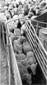
Glenelg Shire Council Cultural Collection
Photograph - Photograph - Sheep loaded onto live transport ship, n.d
Port of Portland Authority archivesFront: (no inscriptions) Back: p. 6 (circled, blue pen, upper centre) Sheep (circled, blue pen, centre) Reduce to 90%/ -2/col (circled, blue pen, centre) -
 Glenelg Shire Council Cultural Collection
Photograph - Photograph - Sheep loaded onto live transport ship, n.d
Port of Portland Authority archivesFront: (no inscriptions) Back: p. 6 (circled, blue pen, upper centre) Sheep (circled, blue pen, centre) Reduce to 90%/ -2/col (circled, blue pen, centre)port of portland archives -
Glenelg Shire Council Cultural Collection
Photograph - Photograph - Sheep loaded onto live transport ship, n.d
Port of Portland Authority archivesFront: (no inscriptions) Back: (no inscriptions)port of portland archives -
 Glenelg Shire Council Cultural Collection
Photograph - Photograph - Ramp to load sheep onto ship moved into position with crane, n.d
Port of Portland Authority archivesFront: (no inscriptions) Back: (no inscriptions)port of portland archives