Showing 67 items
matching red bluffs
-
 Kiewa Valley Historical Society
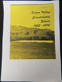
Booklet - Kiewa Valley Consolidated School x5, Kiewa Valley Consolidated School 1953 - 1974
... Upper, Red Bluff, Charleroi and Gundowing North schools on a 10... Dederang North, Kergunyah, Gundowring, Kiewa, Gundowring Upper, Red ...Kiewa Valley Consolidated School was established in 1953 combining Dederang North, Kergunyah, Gundowring, Kiewa, Gundowring Upper, Red Bluff, Charleroi and Gundowing North schools on a 10 acre site with 11 rooms at Kiewa.The above schools are in the Kiewa Valley. The date and number of combined schools give insight into the change in population and families in the Kiewa Valley before and after 1953.Five A4 photocopied pages of a yellow and black booklet including the first 9 pages.kiewa valley consolidated school; dederang; kiewa valley; education -
 Tatura Irrigation & Wartime Camps Museum
Photographs, Kormoran Crew at Carnarvon, 1941
... red bluff... from the lifeboat which landed at Red Bluff, W.A. were... survivors from the lifeboat which landed at Red Bluff, W.A. were ...Photographs taken at the time when the Kormoran survivors from the lifeboat which landed at Red Bluff, W.A. were transported to gaol at Carnarvon, then transported to Harvey POW. Camp. Original photos enlarged and donated to Tatura Museum.Black and white photoshsk "kormoran", hmas "sydney", red bluff, wa, carnarvon, photography, photograph, slides, film -
 Kiewa Valley Historical Society
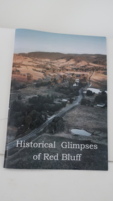
Book - Red Bluff, Historical Glimpses of Red Bluff by Karral Miller
... Book - Red Bluff...Historical Glimpses of Red Bluff by Karral Miller...red bluff...A4 book with glossy colored cover showing the area of Red... Centre 31 Bogong High Plains Rd Mt Beauty high-country red bluff ...A4 book with glossy colored cover showing the area of Red Bluff and the title written in white across the bottom. The back cover is white. There are 50 pages including some with black and white photos.On the title/cover page Karral's signature and date 'February 2021'red bluff, karral miller, kiewa valley -
 Lakes Entrance Historical Society
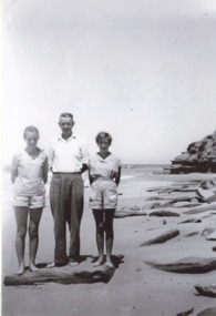
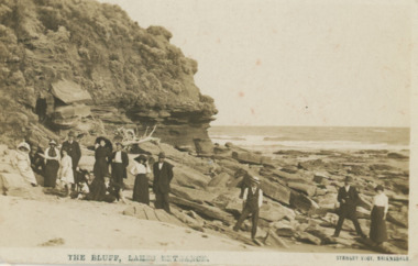
Photograph - Scarce/Fisher at Red Bluff, H D Bulmer, 1956 c
... Scarce/Fisher at Red Bluff...Black and white photograph of west side of Red Bluff... Photograph Scarce/Fisher at Red Bluff H D Bulmer ...Black and white photograph of west side of Red Bluff showing rocks strewn along beach, three people on beach Heather Scarce, Keith Scarce and Kaye Fisher Lake Tyers Beachenvironment -
 St Kilda Historical Society
Photograph, Red Bluff, c. 1906
... Red Bluff ...Red Bluff taken in 1906 by L.W. Brownlie. Copy courtest...Red Bluff, Elwood, Victoria, Australia... Red Bluff taken in 1906 by L.W. Brownlie. Copy courtest ...Copy courtesy LaTrobe Librarycopy of black and white photographRed Bluff taken in 1906 by L.W. Brownlie. Copy courtest of Latrobe Library, Melbourne. St Kilda Historical Collection. 50 Carlisle st, St Kilda. -
 Lakes Entrance Historical Society
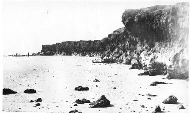
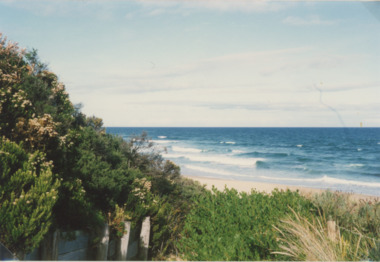
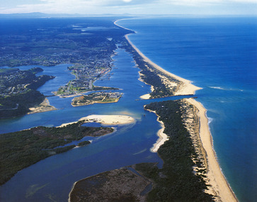
Photograph - Red Bluff, 1992
... Red Bluff...Colour photograph taken from the base at the Red Bluff... the base at the Red Bluff looking to the south east shows low ...Colour photograph taken from the base at the Red Bluff looking to the south east shows low shrubbery on higher elevation above sandy beach, surf breaking with ocean beyond Lake Tyers Victoriaocean, waterways, sand dunes -
 Lakes Entrance Historical Society
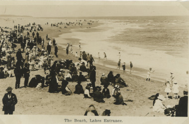
Postcard - People on beach Lakes Entrance Victoria c1910, H D Bulmer, 1910 c
... small boys paddling on waters edge. Glimpse of Red Bluff... small boys paddling on waters edge. Glimpse of Red Bluff ...Sepia toned postcard showing a crowd of excursionists on beach near Eastern Pier all dressed in Sunday Best clothes a few small boys paddling on waters edge. Glimpse of Red Bluff in background Lakes Entrance VictoriaThe Beach Lakes Entrancebeaches, social history, people, recreation -
 Lakes Entrance Historical Society
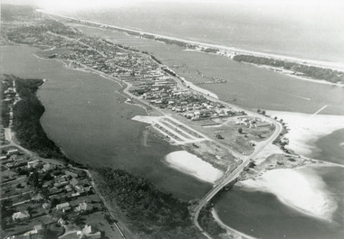
Photograph - Lakes Entrance, 1975c
... as far as Red Bluff. Lakes Entrance Victoria..., boat harbour, sand hummocks and beach as far as Red Bluff ...Black and white photograph of an aerial view of township and Kalimna Heights, showing the North Arm bridge and boat ramp, sand buildup in the lake system, boat harbour, sand hummocks and beach as far as Red Bluff. Lakes Entrance Victoriaaerial photograph, topography, township -
 Lakes Entrance Historical Society
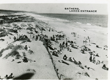
Postcard - Ocean Beach, 1950c
... , remains of a brush fence, Southern Ocean and Red Bluff in distance..., remains of a brush fence, Southern Ocean and Red Bluff in distance ...2 other copiesBlack and white small format postcard of bathers at the ocean beach. It shows a crowd of people on the sand dunes, remains of a brush fence, Southern Ocean and Red Bluff in distance. Taken from original tower, built for Royal Lifesaving Club. Lakes Entrance VictoriaBathers, Lakes Entrance topography, people, beaches, recreation -
 Wodonga & District Historical Society Inc
Domestic object - Lady's Pen and ink set, c1920s
... , Gundowring, Kiewa, Red Bluff, Charleroi and Gundowing North on a 10..., Kiewa, Red Bluff, Charleroi and Gundowing North on a 10 acre ...This pen and ink set is part of a collection donated by Mrs. Jean Raper. It was used by the teacher at Upper Gundowring Primary school, Victoria. The school, number 2733, opened on 13 July 1886. Due to changing demographics in the region, in 1953 the school was merged with schools from Dederang North, Kergunyah, Gundowring, Kiewa, Red Bluff, Charleroi and Gundowing North on a 10 acre site with 11 rooms at Kiewa to become Kiewa Valley Consolidated School.This item is from Raper Collection donated to the Wodonga Historical Society by Mrs. Jean Raper. A china pen and ink set painted with a floral design.pen and ink, personal items, teacher supplies, upper gundowring primary school -
Glen Eira Historical Society
Document - Glen Huntly Pioneers
... to an early quarantine station at Red Bluff, now point Ormond.... Kilda relating to an early quarantine station at Red Bluff, now ...Two items about the fever ship Glen Huntly tragedy of 1840. A typed article from the Historical Society of St. Kilda relating to an early quarantine station at Red Bluff, now point Ormond. A document downloaded from Friends of St. Kilda Cemetery website by Margaret Dunbar dated 01/02/01, who was looking for information on Glen Huntly. The name of the fever ship was memorialized as the names of a Melbourne suburb, railway station and road.glen huntly, glen huntly road, glenhuntly station, diseases, glen huntly pioneers, ships, migrants, typhus road -
 Lakes Entrance Historical Society
Photograph - Lakes Entrance, 1985c
... Island. Glimpse of Red Bluff, Lake Bunga and Lake Tyers in far... Island. Glimpse of Red Bluff, Lake Bunga and Lake Tyers in far ...Photo was cut from Tourist brochureColour photograph showing aerial view of township and the Ninety Mile Beach. Pecks factory on Bullock Island, Old North Arm bridge, bitumen for carpark for future. Fishermen's Club near North Arm Bridge. Photo shows East end of Rigby Island and Snake Island. Glimpse of Red Bluff, Lake Bunga and Lake Tyers in far east. Lakes Entrance Victoriabridges, coast, waterways, topography, township -
 Lakes Entrance Historical Society
Postcard - Red Bluff 1910 c, Stanley Vogt, 1910c
... Red Bluff 1910 c...Sepia toned postcard west side of Red Bluff showing a group... The Bluff Lakes Entrance Sepia toned postcard west side of Red Bluff ...Paired with image 03731.1 for display in 150 years Lakes Entrance 1858 to 2008 held in October 2008Sepia toned postcard west side of Red Bluff showing a group of eight men and five women and a child. Sand washed away exposing vast rocky beach, short vegetation on rocky bluff. Women wearing full length skirts and wide brim hats with veils, men in three piece suits dark in colour on ninety mile beach Lake Tyers VictoriaThe Bluff Lakes Entrancetopography, fashion -
 Federation University Historical Collection
Document, Ken Clements, Peterborough Puzzles, 2009, 2009
... , and is in the centre of the Bay of Martyrs. The bay consists of 20 m high, red..., and is in the centre of the Bay of Martyrs. The bay consists of 20 m high, red ...Massacre Bay is located on Victoria's Great Ocean Road, and is in the centre of the Bay of Martyrs. The bay consists of 20 m high, red limestone bluffs. This paper by Ken Clements considers the origin of the term martyr in connection to this location, and where the Aboriginal massacre may have taken place. Thirteen page document by Ken Clements relating to Peterborough, Victoria. Contents include coastal features, local Aborigines, Bay of Martyrs, Massacre Bay, Massacre Hill, Buckley Creek Run, Pioneer Pastoralists, British Traversers, settlers, Peterborough, Maps, tourism, history method. Photographs by Laurie Moore.aborigines, bay of martyrs, massacre bay, massacre hill, buckley creek run, pioneer pastoralists, british traversers, settlers, peterborough, maps, tourism, history method, childers cove, barque children, murnane bay, sandy bay, dog trap bay, buckley creek, viviennes lookeout, stanhope bay, buttres bay, burnies beach, armstrong creek, flaxman hill, antares rock, lovers nook, crofts bay, clements, worm bay, halladale point, the well, wold dog cove, james irvine monument, curdies inlet, squirrel creek, wallaby creek, boggy creek, whiskey creek, pioneer beach, schomberg rock, young australia, spit, crown of thorns, newfield bay, the grotto, london bridge, point hesse, high cliffs, the arch, cape martyr, little massacre bay, aboriginal massacre, ken clements -
 Kiewa Valley Historical Society
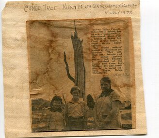
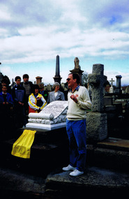
Newspaper clipping 11/7/72 Canoe tree in Kiewa & Photo-Tawonga Homestead
... Upper, Red Bluff, Charleroi and Gundowing North schools on a 10... Dederang North, Kergunyah, Gundowring, Kiewa, Gundowring Upper, Red ...1. Kiewa Valley Consolidated School was established in 1953 combining Dederang North, Kergunyah, Gundowring, Kiewa, Gundowring Upper, Red Bluff, Charleroi and Gundowing North schools on a 10 acre site with 11 rooms at Kiewa. The bark was cut from the canoe tree, by aboriginal craftsmen, to produce a canoe for fishing in the rivers running through the Kiewa Valley either before or just after the 1800's. The tree trunk, located at Kiewa, would have been used at the beginning of European settlement in the Kiewa Valley or just before contact was made. 2. Pictorial record of the graves of early pioneers C Ibbotson, Mrs Elizabeth Eyre and John Eyre who died between 1858 – 1904, all located at Tawonga Homestead 1. The above schools are in the Kiewa Valley. The date and number of combined schools give insight into the change in population and families in the Kiewa Valley before and after 1953. The tree was found along the Kiewa River and indicates that Aborigines lived by the river and used tree bark to craft canoes to cross rivers and to fish in the deeper sections of the river. 2. Pictorial record of the early history of Kiewa Valley pioneers whose descendants have lived and worked in the Kiewa Valley for many years 1. Newspaper article of local school children visiting a canoe tree in Kiewa July 11, 1972. mounted on buff card 2. Black and white photo of pioneer graves at old Tawonga Homestead. Mounted on buff card 1. Handwritten in black ink above newspaper clipping ‘Canoe Tree Kiewa Valley Consolidated School. 11 July, 1972’ Handwritten in pencil at bottom of article ’10 Nov. ‘72’ 2. Handwritten in black ink above photo ‘Tawonga Homestead graves’ Handwritten below photo ‘T Ibbotson D. 1858, Elizabeth Eyre D. 1879, John Eyre D 1879, John Eyre D. 1904 tawonga homestead, canoe tree at kiewa, tawonga graves -
 Wodonga & District Historical Society Inc
Domestic object - Ceramic ink pen cleaner, 1900 - 1920s
... with schools from Dederang North, Kergunyah, Gundowring, Kiewa, Red... with schools from Dederang North, Kergunyah, Gundowring, Kiewa, Red ...Pen-wipers or pen-cleaners were invented to prolong the usefulness of their pens by keeping them clean and dry between uses. This helped to prevent rusting of the nib from water-based inks. In the 1890s and 1900s, with the rise of the fountain pen, pen-cleaners remained a popular desktop accessory, since they could still be used to wipe away the excess ink from the nib and feed of a pen, once it had been refilled in an inkwell. Pen-cleaners died out in the second half of the 1900s when people started using ballpoint pens. This wiper was used by the teacher at Upper Gundowring Primary school, Victoria. The school, number 2733, opened on 13 July 1886. Due to changing demographics in the region, in 1953 the school was merged with schools from Dederang North, Kergunyah, Gundowring, Kiewa, Red Bluff, Charleroi and Gundowing North on a 10 acre site with 11 rooms at Kiewa to become Kiewa Valley Consolidated School.This item is was donated by Mrs. Betty Barberis, a well-known artist in the Wodonga district.ThIs ceramic pen wiper/ cleaner was produced to clean and maintain the nib on an ink pen. It has a blue line pattern at the base, middle and inside the rim.domestic items, writing implements, pen and ink -
 Wodonga & District Historical Society Inc
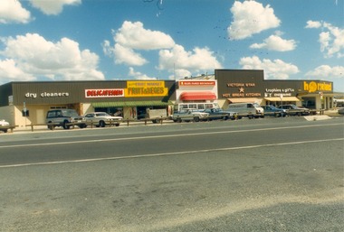
Photograph - Codling Collection 01 - Dunstan’s Corner - Thomas Mitchell Drive, c1987
... mills at Red Bluff on the Mitta and a timber yard at Wodonga. He... Codling. Arthur Dunstan Arthur Dunstan established mills at Red ...These Wodonga photos are part of a collection donated by Miss Olive Codling. Arthur Dunstan Arthur Dunstan established mills at Red Bluff on the Mitta and a timber yard at Wodonga. He also built a sawmill at Glen Wills in 1931 which operated for about 16 years. A larger and more modern sawmill with drying kilns was erected at Eskdale in 1947. He was contracted to build Wodonga’s Municipal sale yards in 1935, followed by the Wangaratta sale yards. This created so many forward orders that he bought a large block of land on the corner of Beechworth and Tallangatta Roads and opened a timber mill and hardware store. The business stood on this corner for about 40 years. A large proportion of the company's timber output was processed at the Wodonga yards into flooring, weatherboards, mouldings etc. and practically the whole output was distributed locally and throughout the Riverina and eastern areas of New South Wales, and Canberra. At its peak Dunstan’s was one of the biggest sawmilling businesses in Victoria and in Wodonga employed 150 people and milled l6,000,000 super feet of timber annually. A super foot is a measurement for timber, equal to one foot square by one inch thick. Arthur Dunstan also built Tower Place in High Street. He died in Wodonga in 1963 and the business was continued on by his sons. Dunstan’s timber yards in Wodonga were sold to Ezerd Industries in 1987 with the retail section being bought by BBC Hardware.This photo collection is significant as it documents how the businesses and buildings in Wodonga have evolved and contributed to community throughout the 20th century.The first business at this location was a timber will and hardware store established by Arthur Dunstan in 1935. It operated there for about 40 years. Businesses from left to right: Dry Cleaner, Delicatessen, Twin Cities Fruit & Vege Market, Ollies Family Restaurant, Victoria Star Hot Bread Kitchen, Trophies and Gifts, and Horseland. This area is not referred to as Southside and the former Horseland premises are not occupied by an Italian restaurant.wodonga businesses, dunstan's corner wodonga, thomas mitchell drive -
 Wodonga & District Historical Society Inc
Photograph - Codling Collection 01 - Dunstan’s Corner and Beechworth Road Roundabout, Mid 1980s
... mills at Red Bluff on the Mitta and a timber yard at Wodonga. He... Codling. Arthur Dunstan Arthur Dunstan established mills at Red ...These Wodonga photos are part of a collection donated by Miss Olive Codling. Arthur Dunstan Arthur Dunstan established mills at Red Bluff on the Mitta and a timber yard at Wodonga. He also built a sawmill at Glen Wills in 1931 which operated for about 16 years. A larger and more modern sawmill with drying kilns was erected at Eskdale in 1947. He was contracted to build Wodonga’s Municipal sale yards in 1935, followed by the Wangaratta sale yards. This created so many forward orders that he bought a large block of land on the corner of Beechworth and Tallangatta Roads and opened a timber mill and hardware store. The business stood on this corner for about 40 years. A large proportion of the company's timber output was processed at the Wodonga yards into flooring, weatherboards, mouldings etc. and practically the whole output was distributed locally and throughout the Riverina and eastern areas of New South Wales, and Canberra. At its peak Dunstan’s was one of the biggest sawmilling businesses in Victoria and in Wodonga employed 150 people and milled l6,000,000 super feet of timber annually. A super foot is a measurement for timber, equal to one foot square by one inch thick. Arthur Dunstan also built Tower Place in High Street. He died in Wodonga in 1963 and the business was continued on by his sons. Dunstan’s timber yards in Wodonga were sold to Ezerd Industries in 1987 with the retail section being bought by BBC Hardware.This photo collection is significant as it documents how the businesses and buildings in Wodonga have evolved and contributed to community throughout the 20th century.The first business at this location was a timber will and hardware store established by Arthur Dunstan in 1935. It operated there for about 40 years. In this photo Horseland occupies the corner premises including a video outlet. On the left is the Victoria Star Hot Bread Kitchen. This area is now know as Southside.wodonga businesses, dunstan's corner wodonga, thomas mitchell drive -
 Wodonga & District Historical Society Inc
Photograph - Mann Collection Album - Dunstan's Corner, Wodonga, C. 1970s
... . Arthur Dunstan Hardware Arthur Dunstan established mills at Red... Dunstan Hardware Arthur Dunstan established mills at Red Bluff ...These town photos are part of a collection donated by Elaine Mann. Elaine was married to David Mann, a successful Wodonga businessman and community leader who passed away in Wodonga in June 2012. David was a member of the Mann family who began their business in Wodonga in 1920. Elaine was a teacher in Wodonga for many years and an active member of the community. Arthur Dunstan Hardware Arthur Dunstan established mills at Red Bluff on the Mitta and a timber yard at Wodonga. He also built a sawmill at Glen Wills in 1931 which operated for about 16 years. A larger and more modern sawmill with drying kilns was erected at Eskdale in 1947. He was contracted to build Wodonga’s Municipal sale yards in 1935, followed by the Wangaratta sale yards. This created so many forward orders that he bought a large block of land on the corner of Beechworth and Tallangatta Roads and opened a timber mill and hardware store. The business stood on this corner for about 40 years. A large proportion of the company's timber output was processed at the Wodonga yards into flooring, weatherboards, mouldings etc. and practically the whole output was distributed locally and throughout the Riverina and eastern areas of New South Wales, and Canberra. At its peak Dunstan’s was one of the biggest sawmilling businesses in Victoria and in Wodonga employed 150 people and milled l6,000,000 super feet of timber annually. A super foot is a measurement for timber, equal to one foot square by one inch thick. Arthur Dunstan also built Tower Place in High Street. He died in Wodonga in 1963 and the business was continued on by his sons. Dunstan’s timber yards in Wodonga were sold to Ezerd Industries in 1987 with the retail section being bought by BBC Hardware.This photo collection is of significance as it documents how the businesses and buildings in Wodonga have evolved and contributed to community throughout the late 20th century. A. Dunstan & Sons Hardware was located at the roundabout on the corner of High Street and Thomas Mitchell Drive (Formerly Tallangatta Road). "Southside Terrace" now occupies this site.wodonga businesses, high st wodonga, dunstan's hardware wodonga -
 St Kilda Historical Society
Photograph, 'Glen Huntley' Passengers Memorial Restoration 1992 - images collection, 1992
... suffering from fever were landed at the Red Bluff St Kilda on 24th... of the passengers suffering from fever were landed at the Red Bluff St Kilda ...The memorial grave was dedicated on 16 April, 1899. Following the 150th anniversary of the arrival of the barque, descendants of John Craig and other "Glen Huntly" passengers restored the memorial. Descendants gathered in 1992 for the unveiling of a plaque marking the restoration.Colour photographRear of each photograph: SK Cemetery 1992 Glenhuntly Descendants. Inscription on memorial: On December 13th 1839, the emigrant ship "Glen Huntly" left Greenock, Scotland and arrived in Hobson`s Bay on 17th April 1840. Many of the passengers suffering from fever were landed at the Red Bluff St Kilda on 24th April 1849. That being the first quarantine station in Victoria. A few days later John Craig James Mathers George Armstrong succumbed to the disease and were interred at The Bluff. Owing to the encroachment of the sea their remains were exhumed and removed to the St Kilda Cemetery on 27th August 1898 by the Board of Public Health.This memorial was erected by public subscription, to mark a notable event in the early history of the colony. Inscription on plaque, unveiled in 1992: This memorial grave was restored by descendants of John Craig and of other "Glen Huntly" passengers. In April 1990 they commemorated the 150th anniversary of the arrival of the barque in Melbourne in 1840. 25th August 1991st kilda cemetery, glen huntly, john craig, james mathers, george armstrong, 1992, glen huntley -
Glen Eira Historical Society
Document - Bakewell Family
... Red Bluff... and Company Ltd. Glaziers Squatters Burnewang Mantons Tooradin Red ...There are 3 items about this family of early European settlers in Victoria: 1/A photocopy of an extract “Early Pioneer Families of Victoria and Riverina” – Henderson Page 441-442 The Bakewell Family of Burnewang and Tooradin”. It includes a photo of John Bakewell (1807-1888). It contains two pages and describes Bakewell’s property expansion. 2/An original copy of handwritten, unsigned undated research notes on John Bakewell property holdings taken from St Kilda Rate Book (1859-1873). It describes the land allotment. 3/A typed, unsigned, undated extract from 'The Howitts in Australia by Mary Howitt' - Mary Howitt, Vic Hist Mag 1913 Vol 3 No. 1. Reference – Memoirs of a Stockman, Harry Peck, 1853 Map, Foot Plot CCXLVI at Kooyong & Glen Eira Road. It provides a brief outline of the lives of brothers Robert and John Bakewell.the bakewell family, early pioneer families, henderson, bakewell john, port phillip, burnewang, bakewell robert, howitt godfrey dr, lord goderich, tooradin, phoebe, friends' school ackworth, yorkshire, nottingham, shaw john wyberg, plenty river, businesses, goldsbrough richard, goldsbrough mort and company ltd., glaziers, squatters, burnewang, mantons, tooradin, red bluff, torbinurruck, great swamp, brenanah, westernport, numerella, snowy river, orbost, green hills b, caramut, lyall william, mickle john, buckland john, notts, england, balderton, weddings, jane emily, howitt emanuel, farnsfield, lever mary, howitt thomas, heanor, derbyshire, howitt godfrey, scales john, exeter college oxford, downing college cambridge, guerard von, wayne john, south warnborough manor, harrison robert, lord john, jamaica, mary alice, dr. miller, miller john francis compton, emmie joan, mary emily, clifton hotel welbeck street, phoebe alice, anne edith, british museum, land values, settlements, st. kilda, elsternwick, inkerman street, st. kilda east, kew, memoirs of a stockman, harry peck -
Glen Eira Historical Society
Newspaper - Falconbridge, Mrs
... Red Bluff... 20/06/1931 Point Ormond Red Bluff Huntly Glen Huntly ...Two items. 1) Photocopy of cutting from The Age, dated 20/06/1931, memories by A Vincent, recalling events in c 1860’s around Ormond and Glen Huntly area. Includes photo of James Bevan and photo of Mrs Falconbridge in the first house in Caulfield. 2) Two enlarged photocopies from The Age cutting, dated 20/06/1931point ormond, red bluff, huntly, glen huntly, shipwreck, elsternwick, st kilda, falconbridge mr, sailors, caulfield, huntly road, glen huntly road, bevan mr, east caulfield, bambra road, grosemont, native plants, house names, cobb and co, coach transport, falconbridge mrs -
Glenelg Shire Council Cultural Collection
Souvenir - Sticker - Portland, n.d
Badge shaped vinyl sticker with depiction of lighthouse on Whaler's Bluff Portland and Harbour in background. Red print 'PORTLAND' across top of sticker; "VICTORIA' around bottom. Mounted on green card. Sticker in clear cellophane packet, '$1.25' in texta, bottom left corner.souvenir sticker, portland -
Glenelg Shire Council Cultural Collection
Souvenir - Glass Ashtray, 1930s
... Portland seafront Whalers Bluff Portland Baths Back: Red and black ...Glass ashtray, rectangular, View Ware. Image is of Railway Line, Whaler's Bluff and walkway to sea baths. Underside of base painted royal blue.Back: Red and black sticker 'EM JENKIN, BENTINCK ST, PORTLAND. NEWSAGENCY & LIBRARY'souvenir of portland, portland seafront, whalers bluff, portland baths -
 Ballarat Tramway Museum
Ephemera - Ticket/s, Melbourne and Metropolitan Tramways Board (MMTB), Set of 11mixed Melbourne and Metropolitan Tramways Board, late 1960's
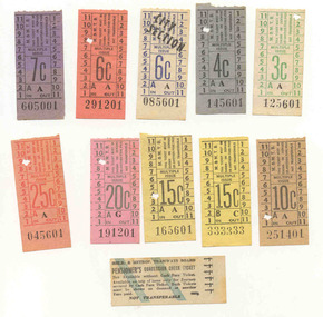
Set of tickets collected by Ray Hall, possibly in his days as a MMTB crew member - conductor? - all have starting numbers in "01", except for two with 6 numerals the same. Shows MMTB style tickets of the time - 1966/67?Set of 11mixed Melbourne and Metropolitan Tramways Board tickets with Ray Hall's papers. May have come from time he worked for the MMTB - all decimal. Tickets have been used . Tickets have not been individually numbered with the Registration Number, but can be identified by their ticket number and denomination. See image btm3465i.jpg See Reg Item 3456 for details of his history. 3c - A125601 - green on white paper 4c - A145601 - black on grey paper 6c - City section - A085601 - blue on white paper 6c - A291201 - black on orange paper 7c - A605001 - black on purple paper 10c - A251401 - black on bluff paper 15c - C333333 - black on yellow paper. 15c - A165601 - black on yellow paper 20c - G191201 - green on pink paper 25c - A045601 - red on light red paper. Pensioners Concession Check Ticket - 444444trams, tramways, tickets, mmtb, melbourne, used tickets -
 Bayside Gallery - Bayside City Council Art & Heritage Collection
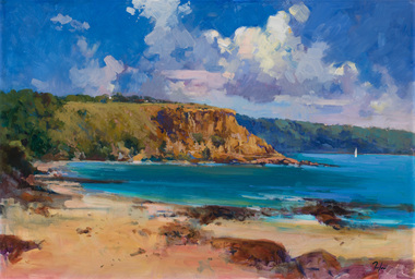
Painting - oil on board, Kevin Taylor, Red Bluff Cliffs, 2003
... Red Bluff Cliffs...red bluff... kevin taylor red bluff cliffs black rock port phillip bay half ...kevin taylor, red bluff, cliffs, black rock, port phillip bay, half moon bay, bayside, coast, beach, boat -
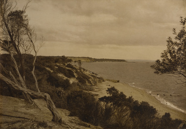
 Bayside Gallery - Bayside City Council Art & Heritage Collection
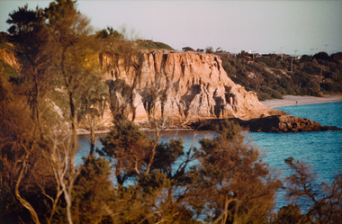
Photograph - type C photograph, Red Bluff Cliffs
... Red Bluff Cliffs...red bluff... photograph red bluff cliffs bay port phillip bay black rock bayside ...photograph, red bluff, cliffs, bay, port phillip bay, black rock, bayside, coast -
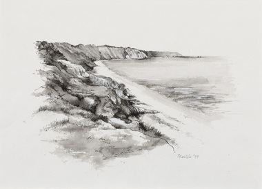 Bayside Gallery - Bayside City Council Art & Heritage Collection
Work on paper - ink and watercolour, Annette Meikle, Coastline and Red Bluff, 1977
... Coastline and Red Bluff...Coastline and Red Bluff... phillip bay Coastline and Red Bluff Red Bluff Cliffs Coast ...In 1977, artist Annette Meikle undertook a commission to illustrate a book recording stories of places and people in the Bayside area. It was published in 1978 as Sandringham Sketchbook, with text by Elizabeth Waters. The sketches were intended to record remaining examples of Bayside’s early architecture and environment, as well as reflect newer architectural changes. Meikle went on to donate 22 of these sketches to Bayside City Council in 2003.Annette Meikle, Coastline and Red Bluff 1977, ink and watercolour, 25.9 x 25.5 cm. Bayside City Council Art and Heritage Collection. Donated by the artist, 2003annette meikle, sandringham sketchbook, elizabeth waters, bay, port phillip bay, coastline and red bluff, red bluff cliffs, coast -
 Bayside Gallery - Bayside City Council Art & Heritage Collection
Photograph - sepia photograph, Sandringham
... red bluff... Sandringham Beach Coast red bluff Port Phillip Bay Ti-tree sepia ...sandringham, beach, coast, red bluff, port phillip bay, ti-tree -
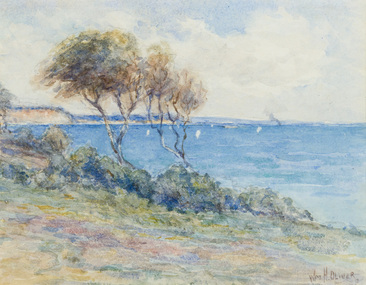 Bayside Gallery - Bayside City Council Art & Heritage Collection
Work on paper - watercolour, William Oliver, Red Bluff at Half Moon Bay, Sandringham, 1929
... Red Bluff at Half Moon Bay, Sandringham...red bluff... coast water landscape boat red bluff half moon bay sandringham ...watercolourcoast, water, landscape, boat, red bluff, half moon bay, sandringham, cliffs, william oliver, bayside, port phillip bay