Showing 75 items matching "reef lines and mines"
-
 Bendigo Historical Society Inc.
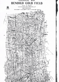
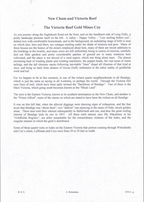
Map - BENDIGO GOLDFIELD VERTICAL PROJECTIONS
... reef lines...reef lines... written top left hand side. Lines of reef described: Christmas...BENDIGO Gold mining reef lines Geological Survey ...Map of Bendigo Gold Field in two sections showing 'vertical projections along several anticlinal axial planes showing pitch, stratigraphical zones, faultlines, shafts and etc.'. Bulletin No 47 written top left hand side. Lines of reef described: Christmas line Lancashire line Nell Gwynne line New Chum line Hustlers line Garden Gully line Sheepshead line Mines along the reef lines are listed. This map forms part of the Geological Survey of Victoria, Structure of Bendigo Goldfield report, No. 47, 1923. H.Herman, late Director of Geological Survey. On bottom of second section : Prepared in the Geological Survey Office, Bendigo, under the direction of H. Herman, late Director of Geological Survey, from surveys by H.S. Whitelaw, Field Geologist, assisted by E.S. Usher, A.J.J. Moore and R.A. Keble.Geological Survey of Victoriabendigo, gold mining, reef lines -
Bendigo Historical Society Inc.
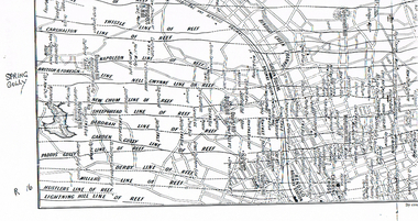
Map - SECTIONS ACROSS BENDIGO GOLDFIELD
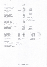
... zones and mines along the reef lines. Key shows rock types... zones and mines along the reef lines. Key shows rock types ...Map in three sections showing sections across Bendigo Gold Field, showing anticlines, synclines, faults, stratigraphical zones and mines along the reef lines. Key shows rock types Castlemaine, Bendigo B1, B2, B3 and B4, and Lancefieldian. First part of map shows sections A-A, B-B and C-C. Reef lines drawn with mines listed: Fault line shown are the Carshalton, Stafford, New Chum, Virginia and Clarence. A datum line shows 600 ft above sea level. On bottom of plan: ' Prepared in the Geological Survey Office, Bendigo, under the direction of H. Herman, late Director of Geological Survey, from surveys by H.S. Whitelaw, Field Geologist, assisted by E.S. Usher, A.J.J. Moore and R.A. Keble.' Second section of map shows sections D-D, and E-E. Fault lines listed are the Tambour Major fault, Carshalton fault, Stafford fault, Nell Gwynne fault, New Chum fault, Deborah fault. Third section shows sections F-F and G-G. Fault lines listed are the Bird Reef fault, Kangaroo Gully fault, Langdon fault, Carshalton fault, Nell Gwynne fault, Spring Gully fault, Hustlers fault, Gravel Hill fault, Ordes fault, Thanet fault. This map forms part of the Geological Survey of Victoria, Structure of Bendigo Goldfield report, No. 47, 1923. H.Herman, late Director of Geological Survey.Geological Survey of Victoriabendigo, gold mining, reef line maps -
Bendigo Historical Society Inc.
Map - MAP PORTION OF BENDIGO GOLDFIELD, Circa 1912
... , Deborah, Garden Gully, Paddy's Gully and Derby lines of reef..., Paddy's Gully and Derby lines of reef. Showing statistical records ...Map: Portion of Bendigo Goldfield showing Sheepshead, Deborah, Garden Gully, Paddy's Gully and Derby lines of reef. Showing statistical records of all the Companies on these lines. Issued by Wood and McNair, Sharebrokers, Bendigo and Eaglehawk. The map illustrates the main lines of reef as they appeared with mines and details of their calls and dividends as well as gold produced. Drawn by mining surveyor and geologist William Henry Cundy, who trained and worked for the Tasmanian Mines Department until 1893, when he moved and settled in Bendigo. Cundy was responsible for the surveying of the southern end of the field of Diamond Hill and beyond.topic, mining, companies, bendigo goldfield, sheepshead , deborah, garden gully, paddy's gully derby, wood and mcnair -
 Bendigo Historical Society Inc.
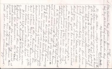
Document - ALBERT RICHARDSON COLLECTION: VICTORIA REEF, TRY ME WELL REEF AND HERCULES REEF
... , 1861. Document details the location of the reef lines and some... details the location of the reef lines and some of the mines ...Three page handwritten document transcribed by Albert Richardson. On top of document: The Victoria Reef, Victoria Spurs, East Victoria Reef, Try McWell Reef and the Hercules Reef. Reference Dickers Mining Record, Vol 1, No. 1 Page g. November 23, 1861. Document details the location of the reef lines and some of the mines and claims along them. For example, page one: 'The main Victoria, really a continuation of the South Victoria, commences at a point to the west of the Mt Korong Road, where the high portion of the ranges is intersected by the head of the Iron Bark Gully, the southern most claim being Ballerstedt and Son's. This line of reef is remarkable from the extraordinary richness of the lodes, not less than from the singular manner in which the gold has been distributed'.Albert Richardsonbendigo, mining, victoria reef line -
 Bendigo Historical Society Inc.
Map - LONG GULLY HISTORY GROUP COLLECTION: MAP OF REEFS AND MINES
... LONG GULLY HISTORY GROUP COLLECTION: MAP OF REEFS AND MINES...The Long Gully History Group - Map of Reefs and Mines...Two pages with lines of reef and mines from Spring Gully... with lines of reef and mines from Spring Gully Reservoir to north ...BHS CollectionTwo pages with lines of reef and mines from Spring Gully Reservoir to north of the Eaglehawk Railway Station. Shown on the map are the lines of reef, the Thistle, Carshalton, Napoleon, British & Foreign, Nell Gwynne, New Chum, Sheepshead, Deborah, Garden Gully, Paddy's Gully, Derby, Miller's, Hustlers, Lightning Hill, Myers Flat, Lancashire, Cook's, Maiden Gully, Johnson's and Millers. Also shown are the Golden Square, Bendigo and Eaglehawk Railway Stations as well as the hills.bendigo, history, long gully history group, the long gully history group - map of reefs and mines, spring gully reservoir, thistle, carshalton, napoleon, british & foreign, nell gwynne, new chum, sheepshead, deborah, garden gully, paddy's gully, derby, miller's, hustlers, lightning hill, myers flat, lancashire, cook's, maiden gully, johnson's, millers, golden square railway station, bendigo railway station, eaglehawk railway station -
 Bendigo Historical Society Inc.
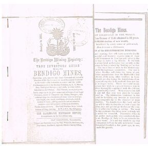
Document - THE BENDIGO MINING REGISTRY
... bendigo mines 1851 - 1883.... Twelve Lines of Reefs. The Gold Problem Scare Solved. Success... and present - of the main situations. Twelve Lines of Reefs. The Gold ...Photocopy of The Bendigo Mining Registry or True Investors guide to all the Bendigo Mines in 1851 and up to 1883. Contains an original poem, Index, names and addresses of Legal Managers, names of Companies and Mining Managers, and reference page to a description of every mine in Bendigo, with length, size, depth, machinery, dividends, capital, number of shares, paid-up, and historical and scientific sketches - past and present - of the main situations. Twelve Lines of Reefs. The Gold Problem Scare Solved. Success of Deep Sinking. E - W & N. S. Parallelograms.document, gold, bendigo mines 1851 - 1883, the bendigo mining registry, r a murray, hay kirkwood, wm welch, district survey office, geological survey of victoria -
 Bendigo Historical Society Inc.
Document - MINING REPORTS - BENDIGO GOLDFIELD PRODUCTION
... Lines of Reef. Also the Napoleon Syncline and Mary McDonald... and Christmas Lines of Reef. Also the Napoleon Syncline and Mary ...Handwritten notes by Albert Richardson, (typed copy) detailing tons of ore and ounces of gold it produced for mines on the Hustlers, Paddy's Gully, Garden Gully, Deborah, Sheepshead, New Chum, Nell Gwynne, Napoleon, Lancashire, Thistle and Christmas Lines of Reef. Also the Napoleon Syncline and Mary McDonald Spurs. Also mentioned is the average per ton.document, gold, mining reports, mining reports, bendigo goldfield production, m d, q r & a r, bendigo advertiser, b m l, burrell's records -
 Bendigo Historical Society Inc.
Document - MCCOLL, RANKIN AND STANISTREET COLLECTION: SUNDRY REPORTS, 1930's
... . Map with lines of reef showing the position of the New Moon.... Map with lines of reef showing the position of the New Moon ...Manilla Folder containing reports from various mines in Bendigo and surrounding areas. 1. 4 page typewritten report on the Balaclava Hill Mine at Rushworth and some newspaper clippings about the mine with a plan of the underground workings; 2. Page from the Árgus' dated 2nd August 1900 featuring an article on the survey of the Garden line of Reefs; 3. 5 page report with maps on the Tooleen Gold Field; 4. Single page report about an unnamed mining area claimed to be on the southern end of the Deborah line of reef. (this could be the 'Three Jays' mine in Sedgwick. P. Wilkin); 5. Hand written report on the Coronation Mine, 2 miles east of Walhalla.; 6. Hand written report dated 1935, of the Queen Mary mine, St. Arnaud.; 7. 1932 report on the North Neangar lease.; 8 4 page report on the Kings Prize Gold Mining Syndicate.; 9. Description of the plant of the Marong Alluvial Company? Also a guide for marking out leases.; 10. Crushing details (1 page) from the 'Enterprise' Mine South of and adjacent to Perseverence.; 11. 1 page crushing details from Rowe Brothers, Mosquito Mine, Fryerstown.; 12 hand written report mentions Arthur Hatfield, Scarsdale.; 13. Map with lines of reef showing the position of the New Moon Consolidated and the New Moon United shafts.; 14, Large scale map from Harrison/Victoria street to Havilah Road showing the positions of the Carlisle, North Garden and Unity Shafts.gold mining, miners' safety cage, sundry reports, mining. bendigo, rushworth, balaclava hill, garden line of reef, toolleen, coronation mine, walhalla, queen mary mine, st. arnaud. north neangar, kings prize gold mining syndicate, marong, enterprise mine, perseverence, rowe brothers, mosquito mine, fryerstown, arthur hatfield, scarsdale, new moon consolidate, new moon united, carlisle, north garden, unity. -
 Bendigo Historical Society Inc.
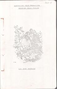
Document - MINING IN BENDIGO COLLECTION: BENDIGO GOLD FIELDS, 1968
... School of Mines... for the years 1851 to 1890, lines of reef, mine shafts and depth..., yield for the years 1851 to 1890, lines of reef, mine shafts ...Typed copy of the Bendigo Gold Fields , collected and arranged by V. R. Dwyer, 1968. On front cover: Australian Gold Production Bendigo Gold Field. Image of tin dish washing. Cover has an image of two people tin dish washing. Notes include a brief history of gold in Australia, Bendigo Goldfield yields, Bendigo Gold Nuggets, Victorian Nuggets, gold prices, yield for the years 1851 to 1890, lines of reef, mine shafts and depth, location, public buildings and organisations and mines listed for each reef. Typed copy of this document is held in Folder 130, number 3621.18.cottage, miners, mining in bendigo, bendigo gold fields index, v r dwyer, strzelecki, edward hargreaves, thomas hancock, henry frenchman, wittscheibe, ballerstedt, fortuna villa, george lansell, the rocks, victoria nugget, dascombe nugget, welcome stranger, welcome nugget, canadian nugget, sarah sands, lady hotham, maryborough, heron nugget, blanche barkley, vicount canterbury, precious nugget, poseidon, gold prices, gold yield 1851 - 1890, location of shafts, mechanics institute, old masonic hall, court, st killians, forrest st methodist church, hospital, baptist church, bendigo gas company, st andrews presbyterian church, bendigo benevolent home, railway, st marys church of england, bendigo m p building society, st pausl church of england, high school, city family hotel, fire brigade, b u f s dispensary, synagogue, beehive store, school of mines, bendigo miners association, st marys convent, dr backhaus, st mathews long gully, salvation army, post office, art gallery, sacred heart cathedral, eaglehawk town hall -
 Bendigo Historical Society Inc.
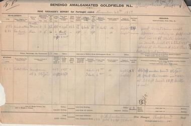
Administrative record - Bendigo Amalgamated Goldfields N.L. Mine Manager's Reports, 1917 - 1920
... , Sheepshead, Deborah and Derby lines of reef hoping to increase..., Sheepshead, Deborah and Derby lines of reef hoping to increase ...In 1917 Bendigo Amalgamated Goldfield Ltd was formed from the amalgamation of 35 companies with operations on the Garden Gully, Sheepshead, Deborah and Derby lines of reef hoping to increase profits of these existing operations through economies of scale. This was difficult to achieve as the shafts involved were spread throughout the goldfield. Diamond drilling and good geological practices were introduced (Pabst was Chief Geologist) leading to some exploration success. However costs were rising rapidly and in 1923 the directors, deciding that mining would soon become unprofitable, dissolved the company returning assets to the original vendors. J.H. Lenten, Mine Manager, received his second class Mine Manager's certificate in September, 1914 at an examination held at the Bendigo Law Courts. One hundred pages of fortnightly manager's reports for Bendigo Amalgamated Goldfields N.L., Sheepshead Shaft. Reports consist of two pages for each fortnight, signed by J.H. Lenten, Mine Manager. Dates of reports range from November 20th, 1917 to 5th May 1920. Categories reported on include: development, stoping, tons from tributors, tons Company's stone, plant and machinery, underground workings, number of rock drill shifts, firewood used, coal burnt, and general remarks. charcoal burnt., lifting waterbendigo, margaret roberts, , goldmining, bendigo amalgamated goldfields, sheepshead shaft, j.h. lenten, mine manager -
 Bendigo Historical Society Inc.
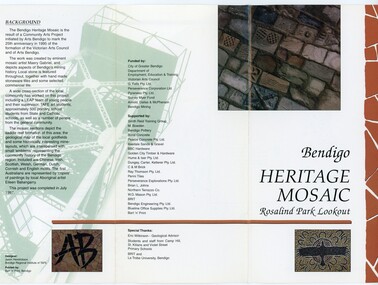
Pamphlet - MERLE HALL COLLECTION: ROSALIND PARK CREATIVE VILLAGE BENDIGO PROJECT PAMPHLET, 1995
... ). It shows the lines of reef, including the famous Hustlers, Garden... the lines of reef, including the famous Hustlers, Garden Gully ...Merle Hall Collection: Rosalind Park Creative Village Bendigo Project Pamphlet for Rosalind Park Lookout - two copies. One side of the pamphlet has a layout image of the five sections of the mosaic and the poppet head base. The sections are numbers 1 to 5 Section 1: A stylised representation of the main Bendigo Goldfield based on a geological plan (Publish in 1992). It shows the lines of reef, including the famous Hustlers, Garden Gully and New Chum. Section 2: A typical cross section of the Bendigo Goldfields Section 3: The mine layout shown in this design features part of the Garden Gully line of reef. Section 4: Shown here is the Iron Bark mine on the Sheepshead reef. It has an interesting pattern of drives, stopes and winzes. Section 5: In this section the artist uses gold as her inspiration. The larger mosaic shows quartz veins winding through the earth containing gold in its various forms. The smaller mosaic represents the atomic structure of gold. It shows the the nucleus, the six shells of the atom, their electrons and orbits. The other side of the pamphlet describes the background of the community arts project, the artist, and volunteer workers, also notes mentioning the Bendigo community history. It also lists the donors for funding and business's that supported the project, with special thanks to Eric Wilkinson - Geolpogical advoser, the students and staff from Camp Hill, St Killians and Violet Street primary schools. BRIT and La Trobe University, bendigo. -
Bendigo Historical Society Inc.
Map - HUSTLER'S & CHRISTMAS LINES OF REEFS - PLAN OF LINES OF SECTION OF REEFS
... and Christmas Lines of Reefs. 8/3/99. Signed ?. Transverse Section... MINING Parish Map Hustler's & Christmas Lines of Reefs Plan ...Underground Survey of Mines Bendigo. Plan of Cross Section Lines Shewing Connections with Trigonometrical Stations and Base Lines. 13/3/99 Signed ? Stirling. Places and mines mentioned Speciman Hill, Tambour Major, Lansell's 180, Victory and Pandora, Great Extended Hustler's, Windmill Hill on Victoria Reef. Next part of map is a Plan of Lines of Section between the Hustler's and Christmas Lines of Reefs. 8/3/99. Signed ?. Transverse Section. Shows Tambour Major Co., near the Christmas Line of Reef, Crosscuts and their depth, geological features and stone encountered. Then shows Thistle Line, Charshalton Line, Napoleon Line, Nell Gwynne Line, New Chum Line, Lansell's No 180 with levels, depths and geological features. Drawing is continued in three parts to fit on paper. Lansell's East Shaft with levels and depths, geological features and stone encountered. Sheepshead Line, Old Shaft, Garden Gully Line, Victory and Pabndora Co with crosscuts, depths, geological features and stone encountered. Paddy's Gully Line, Derby Line, Millers Line, Hustler's Line, Great Extended Hustler's Co with levels, depths, geological features and stone encountered. A note beside a Saddle Reef: 360,000 pounds paid in dividends from this reef. Average ounces per ton gold noted where found. Reference Table for stone and geological features. Datum Line 700 feet above Sea Level Unscannedmining, parish map, hustler's & christmas lines of reefs, plan of lines of section of reefs, ? stirling, specimen hill, tambour major, lansell's 180, victory & pandora, great extended hustler's, windmill hill, victoria reef, tambour major co, christmas line, hustler's line, thistle line, carshalton line, napoleon line, nell gwynne line, new chum line, lansell's no 180, lansell's east shaft, sheepshead line, old shaft, garden gully line, paddy's gully line, derby line, miller's line, hustler's line, great extended hustler's co -
 Federation University Historical Collection
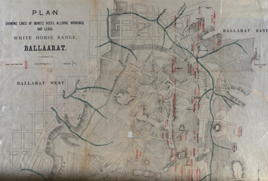
Plan, White Horse Range Ballarat, 1885, 06/1885
... mines...mines... .2) Plan showing lines of quartz reefs, alluvial workings... ballarat plan white horse range white horse goldfields mines reefs ...Two plans .1) Plan of the Ballarat Goldfields showing leads, rivers, streets and topography. Quartz reefs include: Yorkshire, Try Again, Promised Land, Western Slates, Norwegian, Robert's Lode, Finn's, Band and albion, Rothschild, Old Post Office, Queen Lode. Leads include: Navy jacks, Gays, Canadian, Prince Regent, Sailors Gully, White Horse, Little White Horse, Milkmans, Nightingale, Golden Point, Gravel Pits. Scale is 8 Chains to 1 inch .2) Plan showing lines of quartz reefs, alluvial workings and leads, White Horse Range, Ballarat. Leads include White Horse LEad, Little White Horse Lead, One Eye Gully, Terrible Lead, Sailor's Gully, Canadian Lead, Prince Regent Gully, Canadian Lead, Cavs Lead, Navy jacks Lead, Eureka Lead, Old Gravel Pits Lead, Gravel Pits Lead, Nightingale Lead, Malakoff Lead, Milkmans Lead, Redan Lead, Woolshed Lead, Jacksons Lead, Winters Lead, SCtochman's Lead, Canadian Lead. Reefs include: Promised Land, Daniash, Sir Garnet Wolsley, Norwegian, Rothschile, Band and Albion, Finns, Llanberis, Roberts Lode, Tynworths and Black Hill, Oregan, Yorkshire, Try Again, Yorkshire, Post Office, Clarke's, Western Slates, Black Slate, Danks Slates, Eastern Slates, Queen's Lode, Fire Brigade. Mines include Red Streak, New Chum, Tinworths, Woah Hawp, Normanby, Speedwell, Llanberris Extended, Llanberis, Last Chance, Major, Countess, Pioneer and a number of batteries along Main Road Hills include: Mount Clear, Pennyweight Hill, Sovereign Hillballarat, plan, white horse range, white horse, goldfields, mines, reefs, indicators, leigh river, cgt, tinworth, mining -
Bendigo Historical Society Inc.
Document - MINING IN BENDIGO COLLECTION: NOTES ON MINING IN BENDIGO
... the size of the Bendigo Goldfield, the number of lines of reef... mention the size of the Bendigo Goldfield, the number of lines ...Handwritten notes on mining in Bendigo. Notes mention the size of the Bendigo Goldfield, the number of lines of reef and a brief history of goldmining in Bendigo.document, gold, mining in bendigo, mining in bendigo, notes on mining in bendigo, ravenswood sheep run, survey regiment, california hill state school, lansell's 222, mr lansell, camp hill school, high school, park mine (royal hustler's reserve no 1), memorial hall, city mine ( royal hustlers reserve no 2), mining stock exchange, beehive buildings, allan's walk, buckell & jeffrey, fortuna hustlers, great extended huatlers, garden gully united, mining exchange, garden gully united, wattle gully mine, ironbark mine, manchester arms hotel, extended hustlers mine, south belle vue, new chum railway, eureka extended, shenandoah, victoria quartz, the big 180, old chum, gt extended hustlers -
 Bendigo Historical Society Inc.
Document - NEW CHUM, VICTORIA AND HUSTLERS HILL AND REEF LINES
... NEW CHUM, VICTORIA AND HUSTLERS HILL AND REEF LINES... CHUM, VICTORIA AND HUSTLERS HILL AND REEF LINES ...Five page typed document. On top in handwriting ' Original, for self tour'. New Chum Hill is situated in Golden Square, Marong Road on north side, Lilly Street to the east, Chum Street on souther slope and Lansell's Fortuna on the wesern side. Mines on the hill are listed: Lansell's 180, The New Chum and Victoria, the Old Chum, the Lazarus, the New Chum United, the New Chum Consolidated and the Garibaldi. The Mungo group of mines on the New Chum Line of Reef at Eaglehawk are listed: Ellenborough, St. Mungo, Lady Barkly and South Sth Mungo. Victoria Hill mines: Rae's, Wittscheibe and Co., Lansell's 180.Albert Richardson -
 Bendigo Historical Society Inc.
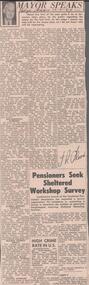
Newspaper - ALBERT RICHARDSON COLLECTION: THE MAYOR SPEAKS: MINE SITES
... reef lines and mines... BENDIGO Mining reef lines and mines Newspaper article 'The Mayor ...Newspaper article 'The Mayor Speaks' dated 12th August 1967, Bendigo Advertiser. Article by J.R. Flood. Mayor of Bendigo, detailing the location of mines including the Duchess of Edinburgh on the New Chum line, the mines on the Christmas line of reef, the Deborah reef mines, and the Sheepshead reef. Mine reclamation schemes are also addressed in the articlebendigo, mining, reef lines and mines -
 Bendigo Historical Society Inc.
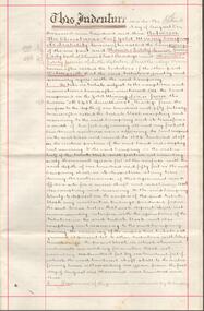
Document - CHRISTMAS REEF GOLD MINING CO. COLLECTION: TRIBUTE AGREEMENT
Hand written agreement for five years from 1st August 1903 and dated 15th August 1903. Lease of land for mining purposes between Christmas Reef Gold Mining Co. and Messrs Eddy and party. Christmas Reef Gold Mining Co. would take a percentage of the gold. Signed by Fred Douglas Jones, Solicitor, Thomas Eddy Senior, James Herbert Eddy, Thomas Donald Eddy, Mr J James, R ?all, Clerk to Mr F D Jones. Document has two purple ink stamps and three red seals. Written on heavy paper with double red lines 1.5 cm from the edges.mine, gold, christmas reef gold mining company, christmas reef gold mining company n. l., fred douglas jones, thomas eddy senior, james herbert eddy, thomas donald eddy, r ?all, mr j james -
 Bendigo Historical Society Inc.
Map - LONG GULLY HISTORY GROUP COLLECTION: GEOLOGICAL MAP - BENDIGO GOLD FIELD
... Mines Department... shows Lines of Reef, Anticlines, Synclines, Shafts, Alluvial... of a Geological Map of the Bendigo Gold Field. Map shows Lines of Reef ...Copy of a Geological Map of the Bendigo Gold Field. Map shows Lines of Reef, Anticlines, Synclines, Shafts, Alluvial Contours Gullies and some street names. Copy is hard to read. There are two pages.bendigo, history, long gully history group, the long gully history group - geological map - bendigo gold field, mines department, h herman, lightning hill line, hustlers line, derby line, paddy's gully line, garden gully line, deborah line, sheepshead line, new chum line, nell gwynne line, british and foreign line, napoleon line, carshalton line, thistle line, christmas line, lancashire line -
 Bendigo Historical Society Inc.
Document - Hustlers, Sheepshead and Deborah lines of reef
... Hustlers, Sheepshead and Deborah lines of reef...Hustlers Hill group of mines... Sheepshead line of reef, Lansell's South Red, White and Blue, shaft ...Albert Richardson was a mining historian who wrote widely on the mines of the Bendigo Goldfield. The park opposite the Goldmines Hotel in Marong Road, is named in his honour. Five page document, hand written by Albert Richardson on lined foolscap and edited with cross-outs and insertions, . The mines along the Hustlers line of reef and the Sheepshead line of reef are described. Mines listed on Hustlers line of reef: Fortuna Hustlers (1888 - 1913), shaft 2,240 feet at rear of Buckell and Jeffrey's offices; Royal Hustlers Reserve No. 2 - two shafts 'City" 860 feet, now covered by R.S.L. building Pall Mall, steel poppet legs 60 ft high and 'Park Shaft" at rear of Camp Hill School, 1,775 feet, steel poppet legs 60 feet high; Hustlers Hill Group first worked by Jonathan Harris in 1853 and bounded by Valentine, Anderson and Ironbark Creek to the north and Milroy Street to the east, one of first areas worked for quartz reefing. It with Garden Gully line west and Victoria Hill Ironbark, formed by far the richest cross section of the Bendigo Goldfield. Great Extended Hustlers (1865-1921) close to intersection of Anderson Street and Hustlers Road, mullock heap against road and shored up around shaft, steel poppet legs now at Wattle Gully mine, Chewton, large winding machine, air compressor south of shaft and 36 head crushing battery. Hustlers Reef (Old Hustlers) and Hustlers Reef No. 1, two shafts, main 2,210 feet, about 220 yards east of Moran Street and against Fenton Street. , No. 1 shaft 1,140 feet and about 155 yards east of Moran Street. Lansell's Comet, Lightining Hill line, 2.100 feet, on Comet Hill approx 70 yards west of Holmes Road, near Comet Creek, steel poppet legs. United Hustlers and Redan (1876-1918), main Redan, 1,830 feet about 155 yards west of Sandhurst Roead, in line with Comet Hill State School, this hill known as Redan Hill. North, or New Hustlers, once known as Agnew Hustlers, wooden poppet legs, south side, Kneebone Street, Eaglehawk. Derby line, Johnson's No. 3, South Johnson's (east shaft of Collman and Tacchi) 439 feet on west wide of Woods Street, south of Wetherall Street. Paddy's Gully Line, south to north, some shafts - Lansell's 'Sandhurst" ('Needle") Eaglehawk Road shaft 2,425 feet, about 50 yards east of Needle Loops, a brick square sided chimney with Cleopatra Needle top. British American, 789 feet, just south of Holdsworth Road. Collman and Tacchi, main shaft 2,588 feet, 60 yards west of Eaglehawk Road, California Gully. Deborah Line of Reef, The Deborah (1932-1954) shaft 2.017 feet, west of Adams Road and south of Abel Street, Quarry Hill. North Deborah (1937 - 1954) shaft 1,151 feet, Breen Street, Quarry Hill, steel poppet legs. Central Deborah (1939-1954) shaft 1,347 feet Sheepshead line of reef, Lansell's South Red, White and Blue, shaft 2,124 feet, north east of Bellevue Road and 220 yards east of Adams Road. The New Red, White and Blue Consolidated (Big Blue) main shaft 2,416 feet. Lansell's Bendigo Battery 105 head, north of 'Big Blue" on his freehold lease, commenced crushing on 24th February 1895. After closing was erected as the Showground's Industrial Hall, July 1926. North Red, White and Blue, burnt down February 1926, new company 1934, closed 1938. Document is part of the Albert Richardson Collection of Bendigo mining history. bendigo, gold mining, deborah line of reef, sheepshead line of reef, hustlers line of reef, royal hustlers reserve mine, hustlers hill group of mines, great extended hustlers, hustlers reef no. 1, lightning hill line, old comet, collman and tacchi, lansell's comet, north deborah, central deborah, dhrrpdhrsf linr og trrg, new red, white and blue consolidated mine, big blue, lansell's bendigo battery, north red, white and blue mine, albert richardson collection -
 Bendigo Historical Society Inc.
Document - South New Moon Syncline Gold Mine No Liability 1934, James Phillips, January 20th 1934
... reef lines...reef lines... Phillips George Phillips gold mine reef lines Two page document ...Two page document, carbon copy typed on flimsy paper. On first page ' South New Chum Syncline Gold Mine No Liability', Bendigo. January 20th 1934. Mine Manager's report, Jas. Phillips typed on bottom of second page. Content includes: 'The level south at the 110 ft was driven over 35 years ago by the late Geo Phillips who had a 20 head mill on the lease and as far as I can remember its about 200 ft south and of course the reef iow well above a few feet in on account of it rising in that direction and thousands of tons has been taken out of that particular block and crushed.... the writer worked on that reef in his younger days and we connected with some old workings above us known as the German's Workings collapsed and closed up from the 100 ft level to the surface'. Document is part of the Margaret Roberts Mining Collection. south new moon syncline gold mine, geo phillips, james phillips, george phillips, gold mine, reef lines -
 Bendigo Historical Society Inc.
Administrative record - East Moon Gold Mining Company Mine Manager's Report Book, 1919 - 1920
... on the Paddy’s Gully and Derby lines of reef at Eaglehawk. A shaft... on the Paddy’s Gully and Derby lines of reef at Eaglehawk. A shaft ...February 1933: East Moon Gold Mining Co. N.L. has been formed with a capital of £25,000 in 36,000 shares of 10/- each issued at 1/-. The company will work an extensive lease on the Paddy’s Gully and Derby lines of reef at Eaglehawk. A shaft was sunk on the Paddy’s Gully line in the property of the New Moon Co. some years ago to a depth of 380 ft. and another shaft was sunk by the same company on the Derby line of reef to 134 ft. In the Paddy’s Gully shaft a large body of spurs 10ft wide at the 256ft plat was exposed and continued downward for 36 ft (56ft?) before passing out of the shaft to the east. A little gold was seen in the stone but no work was done. The development of this formation will be the first work undertaken by the new company. (The Sun News Pictorial Monday 20th February 1933, page 23) Black hard cover book, red binding on spine, one hundred and eighty eight pages of which sixty five are used. Label on front cover: 'East Moon G.M.C . N.L.' Book contains: a. handwritten reports from Alfred Jorgensen regarding the installation of the plant and machinery at the mine b. reports from E.G. Robertson, the Manager of the East Moon Gold Mining Company. Typed report by E.G. Robertson, 8th July 1935 reports on the Paddy's Gully shaft, the Derby shaft and the Hustlers shaft. Entries date from 20th July 1933 to 22nd. August 1935. Mine Manager's book forms part of the Margaret Roberts Collection of Mining records.bendigo, margaret roberts, legal managers, mine manager, east moon gold mining company n.l., e.g. robertson mine manager, alfred jorgensen contractor, paddy's gully shaft, derby shaft, hustler's shaft, -
 Federation University Historical Collection
Map, Ballaarat Gold Field, 1861, 1861
... mines...mines.... Blue dots indicate gold leads, and red lines indicate..., and red lines indicate auriferous quartz reef and outcrops ...A party of surveyors camped by Yuille's Swamp (later Lake Wendouree) and surveyed the countryside for a map to be produced by the Geological Survey of Victoria. In November 2004 the Central Highlands Regional Library presented a special edition of 200 copies of the 1861 map reproduced from a copy in their collection. Original 1861 map of Ballarat showing streets and leads. Blue dots indicate gold leads, and red lines indicate auriferous quartz reef and outcrops of quartz veins."Compiled & Drawn from the Survey of Mining Surveyors Davidson, Fitzpatrick and Cowan & the Plans in the Surveyor General's Office by J. Brahe, 21st October 1861. R. Brough Smyth, Secretary for Mines. The Honourable J.B. Humffray, M.L.A. Commr of Mines.”ballarat, map, ballarat east, lake wendouree, survey, mines, robert davidson, ballarat gold field 1861, yuille's swamp, wendouree swamp, little bendigo diggings, gold leads, old post office hill, specimen hill, bakery hill, black hill, dead horse creek, brown hill, pennyweight hill, clayton hill, soldiers hill, golden point, gum tree flat, white flat, poverty hill, chinese village, robert brough smyth, ballarat map 1861, ballaarat vineyard, dead horse gully, deadhorse creek, invermay, black hill flat, gaelic church, police reserve, magpie range, dalton's flat, caadian lead, rifle butts, powder magazine, bathing house, government camp, gold office, chinese, llanberrris, victoria theatre, charlie napier hotel, united states hotel, grape's hoel, clayton's hill, cattleyard hill, free trade hotel, esmond lead, bakery hill, black hill lead, juvenile reformatory, ballarat orphanage, lady barkly lead, triffet's slaughter yard, little bendigo, melbourne road, t. cowan, thomas cowan -
 Bendigo Historical Society Inc.
Document - TYSON'S LINE - EASTERN LINES
BHS CollectionTyped carbon copy and typed copy of General notes on the lines East of the Hustlers. Lines mentioned are: Hustler's, New Chum, Lightning Hill, Tysons, Slaughteryard, Isabella Mine, Ironstone Hill Reef, Nicholson Reef, on which a mine owned by a man named Stevenson mined a fair amount of gold. Ref. Anon; 1899. Spec. Ed. Aust. Min. Stand. June 1st 1899: p 61. Notes prepared by Albert Richardson.mining, parish map, tyson's line, eastern lines, hustler's, new chum, slaughteryard line, lightning hill, tyson's, isabella mine, ironstone hill reef, nicholson reef, mr stevenson, aust min stand 1 june 1899 -
 Bendigo Historical Society Inc.
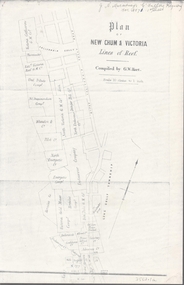
Map - NEW CHUM & VICTORIA LINES OF REEF - PLAN OF NEW CHUM & VICTORIA LINES OF REEF
... NEW CHUM & VICTORIA LINES OF REEF - PLAN OF NEW CHUM...New Chum & Victoria Lines of Reef...Two pages of a Plan of New Chum & Victoria Lines of Reef...MAP goldfields New Chum & Victoria Lines of Reef Victoria ...Two pages of a Plan of New Chum & Victoria Lines of Reef, compiled by G. W. Hart. Taken from J. N. Macartney's G'Fields Registry for 1871. Plan shows leases from High Street to California Gully. Location of the Manchester Arms, British & American Hotel and the Quartz Miners Arms are shown. Townships of Long Gully and Ironbark are shown.map, goldfields, new chum & victoria lines of reef, victoria catharine g m coy, thornton & co, extd victoria reef g m co, ural tribute compy, nil desperandum compy, koch, north victoria g m co, danger hill coy, north endeavour coy, wheadon & co, pilot co, north energetic co, energetic compy, endeavour company, hercules co, victoria gold mines compy, iron duke g m co, golden fleece united, ballerstedt, alfred co, confidence co, prince alfred co, canterbury co, advance co, wells, humboldt co, adventure co, try me well, sterry & co, gibbs & ballerstedt, handy andy, wells?, south adventure co, w rae, victoria reef quartz m co, myra co, jackson, wybrants, burrows & sterry, new chum & victoria tribute, old chum co, ballerstedt, lazarus, watson, koch & hildebrand, lansell & hunt, dennis, abe lincoln co, bonati & co, ellesmere co, moore late menzies, british co, british tribute co, garibaldi, c c co, new chum trib, dobson & co, young chum co, little chum co, old chum co, new chum trib, little chum trib, g w hart, j n macartney's g'fields registry for 1871, manchester arms, british & american, quartz miners arms -
 Bendigo Historical Society Inc.
Document - NEW CHUM & VICTORIA LINES OF REEF - NOTES ON THE VICTORIA REEF GOLD MINES COY
... NEW CHUM & VICTORIA LINES OF REEF - NOTES ON THE VICTORIA...New Chum & Victoria Lines of Reef...DOCUMENT Gold New Chum & Victoria Lines of Reef Notes ...Handwritten notes describing the journey along Eaglehawk Road from the houses, poppet heads and mine tailings, etc. When the alluvial diggings were showing signs of exhaustion, and the fear arose that Bendigo was 'about done', two 'darkies' One named Dido, struck golden stone. They sold out to Ballerstedt and Son, and thus gold mining was revived. These areas were remarkable for the extraordinary richness of the lodes, and the singular manner in which the gold is distributed.document, gold, new chum & victoria lines of reef, notes on the victoria reef gold mines coy, gavan duffy, victoria hill, black lead, prince alfred, ballerstadt & son, goldfields registry, mr macartney, wittscheibe, luffsman -
 Bendigo Historical Society Inc.
Document - NEW CHUM & VICTORIA LINES OF REEF - PRODUCTION OF GOLD (OUNCES)
... NEW CHUM & VICTORIA LINES OF REEF - PRODUCTION OF GOLD...New Chum & Victoria Lines of Reef...DOCUMENT Gold New Chum & Victoria Lines of Reef Production ...Handwritten notes with production of gold from some of the mines. Some have the number of ounces per ton and the average per ton of ore. Mines mentioned are Lazarus, Old Chum 7 Early Grou?, New Chum & Victoria, North Old Chum, Lansell's 180, Victoria Quartz, Gt Central Victoria, Victoria Colsols, South Adventure Group, Adventure, Advance, Try - Me - Well, Prince Alfred, Alfred Co, Ironbark Co, Herc & Energetic.document, gold, new chum & victoria lines of reef, production of gold (ounces), lazarus, new chum & victoria, north old chum, lansell's 180, victoria quartz, gt central victoria, victoria consols, sou;th adventure group, adventure, advance, try - me - well, prince alfred, j r evans, ironbark co, herc & energetic -
 Bendigo Historical Society Inc.
Document - NEW CHUM & VICTORIA LINES OF REEF - NOTES ON VICTORIA HILL
... NEW CHUM & VICTORIA LINES OF REEF - NOTES ON VICTORIA HILL...New Chum & Victoria Lines of Reef...DOCUMENT Gold New Chum & Victoria Lines of Reef Notes ...Handwritten notes describing where the crushing battery was at Victoria Hill. Mentions Wallerstedt's open cut mine. John Brown factory built on the sand dumps. Mentions the views from the Hill of the City of Bendigo, Golden Square and the ranges beyond. Note written by A Richardson.document, gold, new chum & victoria lines of reef, notes on victoria hill, mr weatheritt, new chum & victoria crushing battery, victoria hill, ballerstadt, wittscheibe, john brown factory, a richardson -
 Bendigo Historical Society Inc.
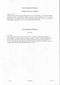
Document - NEW CHUM & VICTORIA LINES OF REEF - NEW CHUM & VICTORIA MINE MANAGER'S REPORTS
... NEW CHUM & VICTORIA LINES OF REEF - NEW CHUM & VICTORIA...New Chum & Victoria Lines of Reef...DOCUMENT Gold New Chum & Victoria Lines of Reef New Chum ...Handwritten copies of four Mine Manager's reports for the New Chum & Victoria dated 13/12/1879, Manager Wm H Grainger, 13/3/1884, Manager W. H. G., 15/3/1886, and 21 /6/1886. Reports mention equipment, costs, and a new Winding Plant where they hauled water before allowing the men to descend. Notes on testing boilers.document, gold, new chum & victoria lines of reef, new chum & victoria mine manager's reports, wm h grainger -
 Bendigo Historical Society Inc.
Document - NEW CHUM & VICTORIA LINES OF REEF - BENDIGO GOLDFIELD
... NEW CHUM & VICTORIA LINES OF REEF - BENDIGO GOLDFIELD...new chum & victoria lines of reef...DOCUMENT Gold new chum & victoria lines of reef New Chum ...Handwritten notes listing Bendigo Mines, their years of operation, ounces of gold taken out, Dividends, Calls, and depth of shaft. Some of the mines only have the year they ceased operations mentioned. Dated 1/3/67. Also, a typed copy.document, gold, new chum & victoria lines of reef, new chum & victoria lines of reef, bendigo goldfield, mines dept, new chum cons, new chum united, eureka extd, south belle vue, old chum, new chum & victoria, lansell big 180, ellenborough, st mungo, sth st mungo, little 180, mining register 1893 - 1902 m d annual reports 1902 on, mines dept quarterly to 1892, south new moon, hercules, ironbark, ironbark south, central r w & blue, stanfield, hercules no 1, north nell gwynne, new chum syncline, central nell gwynne, carshalton b m l, napoleon bml, nell gwynne bml, nell gwynne reefs, monument hill, central deborah, north deborah, deborah, south deborah, neangar, lightning hill, alliance, shellbach, south virginia, catherine reef united, belmont & saxby, lady barkly, unity, vict quartz, new argus, new chum railway, garden gully united -
 Bendigo Historical Society Inc.
Document - NEW CHUM & VICTORIA LINES OF REEF - NEW CHUM RAILWAY MINE MANAGER'S REPORT 1880 - 84
... NEW CHUM & VICTORIA LINES OF REEF - NEW CHUM RAILWAY MINE...New Chum & Victoria Lines of Reef...DOCUMENT Gold New Chum & Victoria Lines of Reef New Chum ...Handwritten excerpts from Mine Manager's Reports from January 1880 to May 1884. Mine Manager Mr. J Alderson. Items mentioned: telephones, mechanical breakdowns, air supply, trouble with flat ropes, water problems, leaning and testing boiler engines.document, gold, new chum & victoria lines of reef, new chum railway mine manager's report 1880 - 84, mr j alderson, o'rourke and henderson, allingham, aitkens, pandora, richard heals, flat ropes, young chum co, horwood's, old chum, harkness, crushing mill, g armstrong, roberts & sons, eureka coy