Showing 36 items
matching residential course
-
 Northern District School of Nursing. Managed by Bendigo Historical Society Inc.
Document - A short list of memories of attending the NDSN nursing course at Lister House Bendigo by Marlene Perriman (Dates and PTS unspecified)
The Northern District School of Nursing opened in 1950 in to address the issues around nurse recruitment, training and education that had previously been hospital based. The residential school was to provide theoretical and in-house education and practical training over three years. The students would also receive practical hands-on training in the wards of associated hospitals. The Northern District School of Nursing operated from Lister House, Rowan Street, Bendigo. It was the first independent school of nursing in Victoria and continued until it closed in 1989. The book "The First of its Kind" was published in 2015. Printed in Bendigo by "Bendigo Modern Press". A short list of memories of attending the NDSN nursing course at Lister House Bendigo by Marlene Perriman (Dates and PTS unspecified). A short list of memories of attending the NDSN nursing course at Lister House Bendigo by Marlene Perriman (Dates and PTS unspecified).all documents were regarding the compilation of the ndsnga inc. book "the first of its kind" -
 Northern District School of Nursing. Managed by Bendigo Historical Society Inc.
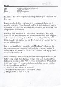
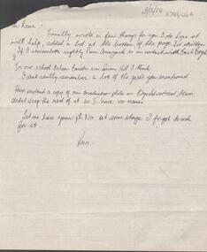
Document - Handwritten (four pages) of memories of attending the NDSN nursing course at Lister House Bendigo by Ann Peters (nee Hassett) PTS 59 (1963 intake)
The Northern District School of Nursing opened in 1950 in to address the issues around nurse recruitment, training and education that had previously been hospital based. The residential school was to provide theoretical and in-house education and practical training over three years. The students would also receive practical hands-on training in the wards of associated hospitals. The Northern District School of Nursing operated from Lister House, Rowan Street, Bendigo. It was the first independent school of nursing in Victoria and continued until it closed in 1989. The book "The First of its Kind" was published in 2015. Printed in Bendigo by "Bendigo Modern Press". Handwritten (four yellow pages) of memories of attending the NDSN nursing course at Lister House Bendigo by Ann Peters (nee Hassett) PTS 59 (1963 intake). Handwritten (four yellow pages) of memories of attending the NDSN nursing course at Lister House Bendigo by Ann /Annie Peters (nee Hassett) PTS 59 (1963 intake). Undated Bendigo Advertiser graduation photograph. Completed her course with PTS 60 after failing a subject.all documents were regarding the compilation of the ndsnga inc. book "the first of its kind" -
 Northern District School of Nursing. Managed by Bendigo Historical Society Inc.
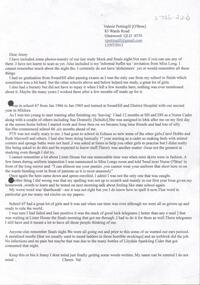
Document - Typed memories of attending the NDSN nursing course at Lister House Bendigo by Val Pettingill (ne O'Bree); PTS 67 (Jan 1966 - Jan 1969
The Northern District School of Nursing opened in 1950 in to address the issues around nurse recruitment, training and education that had previously been hospital based. The residential school was to provide theoretical and in-house education and practical training over three years. The students would also receive practical hands-on training in the wards of associated hospitals. The Northern District School of Nursing operated from Lister House, Rowan Street, Bendigo. It was the first independent school of nursing in Victoria and continued until it closed in 1989. The book "The First of its Kind" was published in 2015. Printed in Bendigo by "Bendigo Modern Press". Typed memories of attending the NDSN nursing course at Lister House Bendigo by Val Pettingill (ne O'Bree); PTS 67 (Jan 1966 - Jan 1969. Typed memories of attending the NDSN nursing course at Lister House Bendigo by Val Pettingill (ne O'Bree); PTS 67 (Jan 1966 - Jan 1969). Referenced photograph and her "invitation to an "informal buffet tea" from Miss Long not attached. Val Pettingill, 83 Wards Road, Glenwood Queenslandall documents were regarding the compilation of the ndsnga inc. book "the first of its kind" -
 Ringwood and District Historical Society
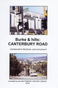
Book, Burke & Hills: Canterbury Road Camberwell to Montrose, by Heathmont History Group - 2014
Soft cover book of 40 pages with spiral wire spine. Compilation of images and descriptive timeline of the geology, geography and European settlement history of Canterbury Road.Soon after beginning at Burke Road Camberwell, Canterbury Road moves into the gentle hills of Canterbury, then on to Surrey Hills, Box Hill and Forest Hill. Further along past these three "hills" come three "monts" - Vermont, Heathmont and at its other end, Montrose, by then in the foothills of the Dandenongs. Grand homes and churches at one end, major and minor shopping centres along the 25km, factories now where farms were, big box stores, fast food outlets, train stations, resrvoir, traffic, residential stretches, modern apartment blocks, parklands, child-minding centres, sporting ovals, a sewage farm, hotels, quarries, commercial developments, plant nurseries, a golf course, bridges, memorials, Asian food shops, telecommunication towers, bushland, creeks, crossroads, traffic lights, mansions, orchards, swamps ... Delaneys Road, renamed Canterbury Road after a 19th century Victorian Governor, is a fascinating study in land use and history as suburban Melbourne has continually diversified and pushed outwards. Compiled by Heathmont History Group, Rita James, Les Prato, Betty Colbert, Jeff Leipold, Gerry Robinson (convenor). -
 Melbourne Tram Museum
Photograph - Digital Image, Kevin O'Reilly, series of three images of the Hawthorn Bridge over the Yarra, c1930, c1930's
Image from CD (Compact Diskette for use in computers) - see Reg Item 135. A series of three images of the Hawthorn Bridge over the Yarra, c1930, during the era with problems with the bridge. See separate article for more details. Richmond 6, Richmond, Richmond 3 on the CD as original files. .1 - Looking from the south west, at the Hawthorn bridge with the temporary wooden bridge being constructed on the south side. Has the cable tram depot in the photo and part of the Burnley racing course. Temporary track on the north side of the steel bridge and crossings can be seen. .2 - Looking along Bridge Road to the east with Hawthorn Bridge in the middle of the photograph. Shows the industrial and residential areas, Hawthorn Railway Station and part of the Burnley Race course, the cable tram depot building. W class tram in Church St Hawthorn and W class tram crossing the bridge on the north side temporary track. Note the cable tram used as a shelter on the north east corner of the bridge. .3 - Looking south along River St towards Bridge Road, with the Yarra River and Hawthorn Bridge on the left side of the photograph. Shows the industry in the area at the time, wool and skin Merchants, north side of the cable depot, housing and the outlook to the river!trams, tramways, hawthorn, yarra river, burnley, richmond, hawthorn bridge -
 City of Kingston
Photograph - Colour, Circa 1993
Edithvale is a suburb in the City of Kingston. It is located between Aspendale and Chelsea on the Port Phillip Bay and built within remnant areas of the Carrum Carrum swamp. The foreshore precinct comprises a wide sandy beach, with low sand dunes and numerous historic boat sheds. The suburb consists of older style dwellings and former holiday houses, combined with mid-century housing and newer homes. The large blocks are increasingly subdivided and the existing dwellings demolished to accommodate units and townhouses, thus changing the landscape of the area and reducing the tree canopy.The beachside suburb of Edithvale was previously part of the extensive Carrum Carrum Swamp. The area was once a source of fish and eels for the Mayone-Bulluk clan of the Bunurong people. Over time the area was drained and predominantly devoted to dairy farming and holiday houses. The farms were gradually sold and subdivided with a large number of homes built after World War II and in the 1960s. Edithvale is mainly residential with a shopping strip along Nepean Highway but little significant industry was ever established in the area apart from a plaster works and confectionary factory, both now closed.Aerial colour photograph of Edithvale as viewed from Alexandra Avenue in the north to Ella Grove Chelsea/Edithvale in the south. The area is built-up with residential housing and facilities including Edithvale Primary School, numerous churches and the Edithvale Railway station. Large sections depict the remnant Carrum Carrum swamp. Edithvale Common and the former "Duck Inn" (Melbourne Water/Friends of Edithvale Seaford Wetlands) can be seen. Edithvale Recreational reserve, the velodrome and Edithvale Public Golf Course are prominent. The image shows vacant land in the area now known as Aspendale Gardens and the newer residential section of Chelsea Heights is not developed. A bike path has been established to cover the secondary drain. The Golf Links Court residential development located off Hughes Avenue is a large vacant block.Yellow circular adhesive sticker on plastic Black ink (marker): * (asterisk) Black type on white adhesive sticker: P000108edithvale, aspendale, chelsea, carrum carrum swamp