Showing 163 items
matching river mouth
-
 Ballarat Heritage Services
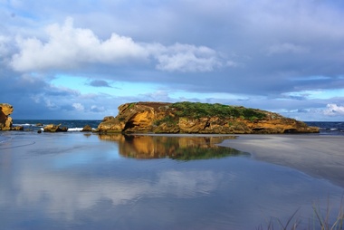
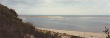
Photograph - Digital photographs, L.J. Gervasoni, Middle Island, Warrnambool, 2012
... victoria river mouth coast ocean island middle middle ...Digital images of Middle Island Stingray Bay warrnamboolvictoria, river, mouth, coast, ocean, island, middle, middle island, warrnambool, merri, merri river -
 Ballarat Heritage Services
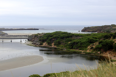
Photograph - Digital photographs, L.J. Gervasoni, Stingray Bay and the Mouth of the Merri River, 2016
... Stingray Bay and the Mouth of the Merri River...Digital image of the mouth of the Merri River at Stingray... stingray bay merri river mouth Digital image of the mouth ...Digital image of the mouth of the Merri River at Stingray Bay. landscape, seascape, geology, warrnambool, coast, coastal, stingray bay, merri river, mouth -
 Glenelg Shire Council Cultural Collection
Postcard - Postcard - Nelson, Victoria, n.d
... , showing the bridge, township and river mouth. Rose Series De Luxe..., township and river mouth. Rose Series De Luxe colorview NO 1213 ...Coloured photo postcard, aerial view of Nelson, Victoria, showing the bridge, township and river mouth. Rose Series De Luxe colorview NO 1213Back: Maker details. 'Aerial view of Nelson Victoria'postcard, nelson -
 Warrnambool and District Historical Society Inc.
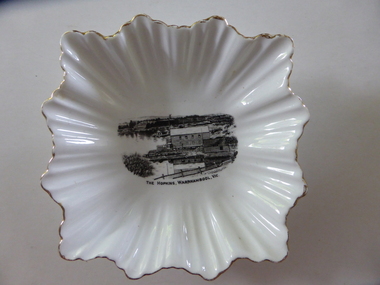
Plate, The Hopkins Warrnambool
... , England. The scene depicting the Hopkins River mouth shows... River near its mouth. On the base is a blue stamp of the maker.... The scene depicting the Hopkins River mouth shows the Lyndoch ...This is a dish sold to tourists visiting Warrnambool in the 1920s as a souvenir of Warrnambool and the Hopkins River. It was made by the Royal Stafford Bone China Company which was founded in the mid 1800s and based in Stoke-on-Trent in Staffordshire, England. The scene depicting the Hopkins River mouth shows the Lyndoch windmill, the Lyndoch bungalow built in the early 1920s by Florence Lake, Proudfoots Boathouse and the Rowing Club building. This dish is an interesting example of the high-quality souvenirs sold to tourists in the mid 1920s. Local Warrnambool residents may also have purchased an item such as this. Souvenir items depicting local scenes are still sold today in most places in Australia.This is a square-shaped white china dish with a fluted edge and gold colouring on the edge of the fluting. In the centre of the dish is a black and white image of the mouth of the Hopkins River near its mouth. On the base is a blue stamp of the maker of the dish. ‘The Hopkins, Warrnambool, Vic.’ ‘Guaranteed Royal Stafford English Bone China, Made in England’ hopkins river, warrnambool, lyndoch, warrnambool, history of warrnambool -
 Phillip Island and District Historical Society Inc.
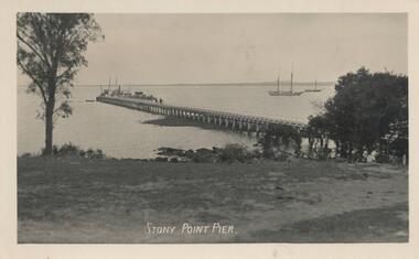
Photograph - Post Card, Stoney Point
... : Postcard of the Powlett River near the mouth....Stony Point Pier Breakers Kilcunda 182 Powlett River near... at Kilcunda. 450-25: Postcard of the Powlett River near the mouth ...Three from a collection of Postcards donated by Mary Karney450-23: Postcard of the Stony Point Pier on Mornington Peninsula. Ferries went from Cowes to Stony Point often via French Island. 450-24: Postcard of the Breakers at Kilcunda. 450-25: Postcard of the Powlett River near the mouth.Stony Point Pier Breakers Kilcunda 182 Powlett River near the mouth 86stony point pier, mary karney, kilcunda, powlett river -
 Lakes Entrance Historical Society
Photograph - Mouth of Snowy River, M Fish, Cape Conran Road Marlo Victoria, 2000 c
... Mouth of Snowy River...Colour photograph of mouth of Snowy River from Cape Conran...Waterways Rivers Colour photograph of mouth of Snowy River ...Colour photograph of mouth of Snowy River from Cape Conran Road Marlo Victoria. Also a second colour photograph of Snowy River mouth taken from a different anglewaterways, rivers -
 Mission to Seafarers Victoria
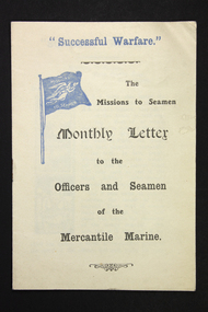
Flyer - Newsletter, Mission to Seafarers, "Successful Warfare" - The Missions to Seamen Monthly Letter to the Officers and Seamen of the Mercantile Marine, 1914-1918
... black and white printed hand drawn graphics of a river mouth... black and white printed hand drawn graphics of a river mouth ...The newsletter was published to address the Mercantile Marine primarily officers in the service. This is the number 19. The term "Merchant Navy" was coined in 1919 by King George V. So this foyer predates 1919.An unusual example of newsletter circulated by the Missions to Seamen (UK) during WW1. The aim may well have been to boost morale but clearly targeting Merchant mariners.Small paper and ink (2 colours, black and blue) 4 page stapled paper pamphlet/booklet. First page features some small black and white printed hand drawn graphics of a river mouth and a decorative angel or female. ww 1, mercantile marine service, mercantile marine, ww1, first world war, great war -
 Flagstaff Hill Maritime Museum and Village
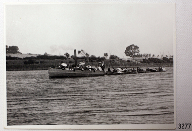
Photograph - Vessel, Steam Launch, Mrs. A. Dawson, Lady Loch, Feb 1907 - Jun 1910
... Jubilee Park towards Warrnambool and the river mouth. A similar... Jubilee Park towards the river mouth. There are many figures... Jubilee Park towards Warrnambool and the river mouth. A similar ...The photograph shows the steam launch Lady Loch towing five rowing boats full of passengers on the Hopkins River at Warrnambool. The boat is travelling downstream from the riverbank near Jubilee Park towards Warrnambool and the river mouth. A similar trip in 1909 was a fund-raising excursion when the Lady Loch was to tow boats from Flett & Sons' boating establishment on the Hopkins River, travelling towards Jubilee Park. The photograph was taken between February 1907 and June 1910 by Mrs A. G. Dawson from the Hopkins River Bank at “Allandale”, which she was leasing. She took another photograph that day, which was published in the Warrnambool Standard on 24th March 1973. At the time of the photograph the launch Lady Loch was owned by James Flett & Son who operated a boatshed on the bend of the Hopkins River. The boat was described as “a fine little steamer”. In 1916 it was licenced to carry 42 passengers. The LADY LOCH: - In February 1884 Mr Sutton’s steam launch had the name of Lady of the Lake. The boat was part of the entertainment for a Sunday school picnic at Ballarat Lake and Gardens. In October 1884 Mr Ivey from Lake Wendouree purchased two vessels, the steamer Ballarat and Mr Sutton’s well-known and popular launch, Lady of the Lake, to join his own fleet of pleasure boats. In November 1887 Mr Mark Hooper’s purchase of a ‘new’ pleasure boat, Lady of the Lake, arrived in Colac to be an addition to his boating business. The launch had been transported by road from Ballarat, but the boiler and the engine had travelled by rail the previous day. In June 1888, Fanny Nelson purchased the steam launch Lady of the Lake for her Nelson’s Boating and Fishing Establishment on the Hopkins River, Warrnambool. She renamed it Lady Loch. People have suggested the mane was in honour of the wife of the then-current Governor of Victoria, Sir Henry Loch, and the local paper stated that Lady Loch flew the Governor’s colours of yellow, black and blue on her first trip under Nelson’s ownership, Sunday 12th August 1888. In 1890 Fanny Nelson sold her complete business, including Lady Loch, to Mr Chapman. in January 1897 James Flett & Sons, already involved in boating, purchased the business from Chapman. In January 1916, Flett advertised everything for sale, including the boatshed and the steam launch Lady Loch. NOTE: - at least three vessels in Victoria were named Lady Loch; a river launch (ca 1884-ca 1916), a steamer ferry (1884-1920s) and a government steam lighthouse tender HMS Lady Loch (1886-1962)The photograph of the Lady Loch pleasure steamer represents the social and recreational activities of late 19th-century people from Warrnambool and the local district. It shows an example of the pleasure craft of that era. The history of the Lady Loch includes the history of fishing and boat hire businesses of that period. The photograph is also connected with an early Warrnambool buat builder James Flett & Sons. representing the maritime history of the town.Photograph, black and white, of the steam launch Lady Loch towing five rowing boats downstream on the Hopkins River from Jubilee Park towards the river mouth. There are many figures on the boats. The photograph was taken from a property called Allandale on the south river bank between February 1907 and June 1910. The photographer was Mrs A. G. Dawson. The Lady Loch was owned by Mr James Flett & Sons at that time. The photograph is mounted on card.flagstaff hill, warrnambool, shipwrecked-coast, flagstaff-hill, flagstaff-hill-maritime-museum, maritime-museum, shipwreck-coast, flagstaff-hill-maritime-village, lady of the lake, lady of the lake steamer, lady loch steamer, lake colac steamer, hopkins river warrnambool, jubilee park warrnambool, francis maria mann, andrew abernathy nelson iiird, hopkins hotel, nelson's boathouse, chapman's boathouse, flett's boathouse, fanny (francis) nelson, james flett & sons -
 Port Fairy Historical Society Museum and Archives
Photograph
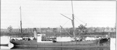
... the vessel was wrecked at the mouth of the Mōkihinui river... mouth. ship boat sea river SS Lawrence Steamer coal New Zealand ...The mining company in Seddonville New Zealand purchased a small steamer, SS Lawrence, to transport coal, but in 1891 the vessel was wrecked at the mouth of the Mōkihinui river. The remains of the ship can sometimes be seen today at low tide on the beach on the south side of the Mōkihinui River mouth.Black & white photographship, boat, sea, river, ss lawrence, steamer, coal, new zealand, mokihinui river, shipwreck -
 Flagstaff Hill Maritime Museum and Village
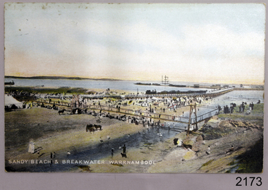
Postcard - Coastal Scene, Joseph Jordan, Sandy beach & breakwater Warrnambool, 1910
... are gathered on the sandy beach beside the river and near the river... the river mouth. They are on and below the footbridge, along ...The coloured postcard depicts the Port of Warrnambool in the early 1900s. It shows the Breakwater, completed in 1890, the Viaduct, and the Merri River footbridge. There are many people on the sandy river banks, beach and bridge, and some are on the rocks of Middle Island. The printed postcard was made in England and is one of the Jordan Series produced by Joseph Jordan, a renowned photographer in Victoria's Western District.The postcard is locally significant as a record of the early footbridge over the Merri River, and the Viaduct before the space between the pylons was filled it. It shows the use of horses as a means of transportation. The photograph is also associated with Joseph Jordan, a renowned Victoria's Western District photographer.Postcard, coloured, showing the Port of Warrnambool. People are gathered on the sandy beach beside the river and near the river mouth. They are on and below the footbridge, along with several horses. Some are on the rocky Middle Island. There is a white ship in port. There is a jetty on the left, and buildings at the start of the breakwater. An inscription is printed at the bottom of the picture. The picture is one of the Jordan Series. It was printed in England in 1910."SANDY BEACH & BREAKWATER AT WARRNAMBOOL" "JORDAN SERIES" "PRINTED IN ENGLAND" "1910"warrnambool, shipwreck coast, flagstaff hill, flagstaff hill maritime museum, flagstaff hill maritime village, postcard, merri river, footbridge, warrnambool breakwater, breakwater, viaduct, middle island, port of warrnambool, jordan series, printed in england, 1910, joseph jordan, jordan photography -
Glenelg Shire Council Cultural Collection
Negative - Negative - Nelson, Victoria, c. 1936
... across the river looking towards mouth of the Glenelg.... and white photo. Nelson Vic. View across the river looking towards ...Transparency for black and white photo. Nelson Vic. View across the river looking towards mouth of the Glenelg. -
Glenelg Shire Council Cultural Collection
Negative - Negative - view of Glenelg River, Victoria, 1934
... across river looking towards mouth of the Glenelg River..... View across river looking towards mouth of the Glenelg River ...Part of a collection of photographs taken by Zillah Maschmedt in 1934. Zillah was a teacher from South Australia.Negative for black and white photo. Nelson Victoria. View across river looking towards mouth of the Glenelg River.zillah maschmedt, photography, glenelg river, nelson -
 Warrnambool and District Historical Society Inc.
Book, The Holy Bible, 1838
... for his paintings of Tower Hill and the Hopkins River mouth. ... of Tower Hill and the Hopkins River mouth. This book is retained ...This book is one volume of a series of six volumes of Bible commentaries. It was a 30 year project for the writer, Adam Clarke. He was the great uncle of Daniel Clarke, a 19th century resident of Warrnambool. Daniel Clarke, as a social worker for the Anglican Church, established the Framlingham Aboriginal Reserve in the 1860s. For thirty years he was a prominent businessman in Warrnambool as a photographer and artist. He is well-known today for his paintings of Tower Hill and the Hopkins River mouth. This book is retained not only because of its antiquarian value but also because of its link with Daniel Clarke, important in Warrnambool’s 19th century history. This is a hard cover book with a black leather spine and black leather trimming on the cover edges. The cover is green with gold lettering and ornamentation on the spine. The pages have a mottled blue and brown pattern on the edges. The cover is a little torn and stained. adam clarke, daniel clarke, bible commentary -
 Warrnambool and District Historical Society Inc.
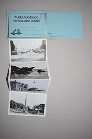
Folding Postcard, Murray Studios, Warrnambool, c.1960
... of Warrnambool scenes – the Hopkins River mouth, the Botanic Gardens... scenes – the Hopkins River mouth, the Botanic Gardens, Liebig ...This is a Warrnambool folding post card sold to tourists and locals in the mid 20th century. The card contains photographs of Warrnambool scenes – the Hopkins River mouth, the Botanic Gardens, Liebig Street, Fletcher Jones gardens etc. Warrnambool has been promoted as a tourist town since the late 1800s and attracts visitors in both the summer months (beaches, coastal scenery etc) and the winter months (visit of Southern Right whales and major sporting events). This card is an example of a local tourist souvenir sold in places such as Warrnambool in the mid 20th century and ensuing decades.This is a postcard with a cover photograph in colour and twelve other colour photographs folding up in concertina fashion. One page has space for a stamp and an address.Warrnambooltourism in warrnambool, history of warrnambool -
 Flagstaff Hill Maritime Museum and Village
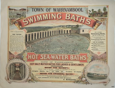
Poster - Recreation, Town of Warrnambool Swimming Baths, ca. May 1884
... and the Merri River Mouth with vessels in the water, The inside... Island and the Merri River Mouth with vessels in the water ...The poster advertises these Swimming Baths as “the most complete in the Southern Hemisphere”. In February 1877 a Baths Company (1050 shares) was formed in the town of Warrnambool for the establishment of the baths at the south end of Gillies Street. The baths were filled with sea water from Lady Bay, originally pumped by a windmill situated near the current Surf Lifesaving Club and carried by iron pipes to the Public Baths; later the water was pumped by a gas motor. Hot and cold fresh water baths were advertised. The gentlemen’s bath was 100 feet long and 50 feet wide, of graduating depth. A second bath, solely for ladies, was 60 feet long by 30 feet wide. Hot Sea water Baths were also part of the institution, and were sought after for their ‘wonderful curative powers’, and ‘incomparable’ as a ‘tonic for the feeble’. In June 1881 the Hot Sea Baths were opened, and both hot and cold water baths were supplied at reasonable charges. Patrons came from near and far to receive the benefits. The manager of the Baths was J. Kirkpatrick. The Baths Company struggled for several years without success, so in 1883 the baths were sold to the Borough Council for 1250 pounds. The original shareholders received nothing for their outlay; the overdraught was over the sale price. In May 1884 the Council announced that an estimated they has spent 1000 pounds in improving the baths since purchasing them and were now returning an income of 11 per cent. Historically significant to Warrnambool and the recreational facilities available in the 1880s to 1900s. The remains of the baths are still visible to the public today.Poster on heavy cream paper, landscape orientation, with coloured print. The poster advertises the Warrnambool Swimming Baths. It has several drawings such as Middle Island and the Merri River Mouth with vessels in the water, The inside of the Baths facility, the men's baths with the adjacent bathing rooms and figures in and out of the water, a cottage with figures in the garden, and fenced buildings with a windmill and aqueduct or pipes. The text describes the location and advantages, the opening times and various costs. It was printed in Ballarat by F.W. Niven & Co. Lithos."TOWN OF WARRNAMBOOL" "SWIMMING BATHS" "HOT SALT-WATER BATHS FOR LADIES AND GENTLEMEN" "HOURS FOR BATHING fROM 7 a.m. to 9 p. m. Closed on Sundays at 10 a.m." Single Bath 1s [1 shilling]; or 10s per Dozen Tickets" "HOURS FOR SWIMMING BATHS: Ladies and Gentlemen, from 6 a.m. to Sunset, Sundays 6 a.m. to 10 a.m." "Every information can be obtained from the Manager, J. Kirkpatrick" "HOT SEA-WATER BATHS ... strongly recommended by the Medical Faculty" "Hot and Cold Fresh Water Baths" "Showers etc." "LIST OF CHARGES ... Single Season Ticket, Single Monthly Ticket, Single Bath without towel ... with towel.. Tickets per dozen without towel, with towel..." "The Baths are situated at the end of Gillies Street, in the rear of the Post Office, and are of salt water pumped by gas motor continuously from the sea. The Swimming Bath is 100 feet long by 50 feet wide, of graduating depth; and a second bath for ladies' use solely, 60 feet long by 30 feet wide. The hot Sea-water Baths in connection with this institution have been extolled far and wide for their wonderfully curative powers in cases of rheumatism, sciatica, and nervous afflictions generally. As a tonic to an enfeebled system, they are incomparable, These Baths, the most complete in the Southern Hemisphere, have been recently re-erected and fitted with marble plunges, and everything provided for the comfort and convenience of invalids and visitors." "F.W. NIVEN & Co, LITHOS, BALLARAT"flagstaff hill, warrnambool, warrnambool swimming baths, hot sea water baths warrnambool, warrnambool baths company, f.w. niven & co, warrnambool therapudic baths, town of warrnambool, swimming baths, hot sea water baths, salt water baths, ladies' baths, gentlemen's baths, warrnambool town baths, j kirkpatrick -
City of Kingston
Photograph - Colour, 29 January 1993
... River marina is prominent and the river mouth as it meets Port... is prominent and the river mouth as it meets Port Phillip Bay ...Bonbeach, Carrum and Patterson Lakes are suburbs in the City of Kingston. Bonbeach and Carrum were holiday destinations in early 20th century and over time the housing has converted to permanent residential structures. In Patterson Lakes, the area consists predominantly of newer housing developments and the tidal canal system which is accessible to many dwellings joins Port Phillip Bay.Bonbeach, Carrum and Patterson Lakes were previously part of the extensive Carrum Carrum Swamp. The area was once a source of fish and eels for the Mayone-Bulluk clan of the Bunurong people. Over time the area was drained and this allowed farming at Carrum and Bonbeach, although the area was prone to flooding. In the early 1920s and 30s the land was converted to residential dwellings. In 1973 investigations commenced nearby to Bonbeach and Carrum into the development of a unique residential area comprising canals and waterways. It was originally proposed to be known as "Gladesville". Circa 1974, the area was rezoned from rural to residential and named Patterson Lakes. Development has been continuous since the 1970s with staged construction of the waterways, residential housing, and supporting infrastructure and facilities.Laminated colour aerial photograph of the Bonbeach, Carrum and Patterson Lakes region within City of Kingston. This 1993 image includes Bonbeach High School prior to demolition, Bonbeach Primary School and Patterson River Golf Club. Sections of Patterson Lakes are not yet developed, including Rhode and Staten Islands. Long Island Point appears to be a recent development with many spare blocks and new houses under construction. The Patterson River marina is prominent and the river mouth as it meets Port Phillip Bay. The Carrum railway station is visible.Black type on white adhesive sticker: No. 6661 Black type on white adhesive sticker: 26E/6661, 29/1/93, 4.25 pm Black type on white adhesive sticker 29-1-93 Yellow circular adhesive stickerbonbeach, carrum, patterson lakes, patterson river, carrum carrum swamp, canals and waterways -
 Lakes Entrance Historical Society
Photograph - Mouth of Yerang River, Fish M, Cape Conran Victoria, 2000
... Mouth of Yerang River...Also a second colour photograph of Yerang river back from...Colour photograph of mouth of the Yerang River east of Cape... mouth 05120.1 9 x 25 cm Waterways Coast Rivers Colour photograph ...Also a second colour photograph of Yerang river back from mouth 05120.1 9 x 25 cmColour photograph of mouth of the Yerang River east of Cape Conran Victoriawaterways, coast, rivers -
 Flagstaff Hill Maritime Museum and Village
Furniture - Table, Ralph Speirs, Warrnambool Triton Woodwork Club, 2009
... to the river mouth. The first Hopkins River bridge was built in 1862... across the river close to the river mouth. The first Hopkins ...The turpentine timber used to construct this table was originally used to build the second Hopkins River bridge in 1895. That long timber truss road bridge was built across the river close to the river mouth. The first Hopkins River bridge was built in 1862. That bridge was replaced by the second bridge, built in 1895. In 2001 the new third bridge was built to replace the 1895 bridge, in a design to look similar to the 1895 bridge. The timber from the second bridge was recycled to make this hall table, a cheeseboard presented to the Mayor at that time, and other mementos. The plaque attached to the table states the table was made in 2009 by Ralph Speirs, Warrnambool Triton Woodwork Club. The table is significant for its connection with the second Hopkins River bridge, built in 1895. The timber used to make the table has been recycled from the second Hopkins River bridge that was destroyed to make way for the new, third bridge. The Timber Truss Hopkins River Bridge was classified with State Significance on 16th April 1996, being the oldest of six surviving timber truss bridges in Victoria and the most intact timber road bridge of any type for its size and age. Its design was unique within Australia. It was the largest timber bridge built in Victoria during the 1890s. The bridge was of importance to the economical development of the region, opening up access to allow ease of trade and social connections between the eastern region of southwest Victoria and the town, later city, of Warrnambool and regions further west.Table made from turpentine timber. The timber was recycled from the second Hopkins River Bridge after the bridge was destroyed. The bridge was built in 1895. The table was constructed in 2009 by Ralph Speirs, Warrnambool Triton Woodwork Club. The front corners of the table are rounded and bthe back corners are straight. A plaque with eight rows of text is attached to the table."TABLE BUILT FROM TURPENTINE TIMBER RECYCLED FROM THE SECOND HOPKINS RIVER BRIDGE, BUILT IN 1895 AND DEMOLISHED IN 2000 TO BE RPLACED BY THE PRESENT THIRD BRIDGE. CONSTRUCTION BY RALPH SPEIRS, MEMBER OF WARRNAMBOOL TRITON WOODWORK CLUB, IN 2009"flagstaff hill, warrnambool, hopkins river, bridge, 1895, 2009, ralph speirs, warrnambool triton club, domestic furniture, table, hall table, side table, timber table, hall stand, furniture -
 Warrnambool and District Historical Society Inc.
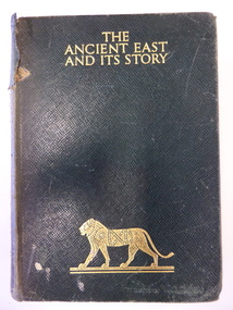
Book, The Ancient East and it's story, Mid 20th century
... of Lyndoch, near the Hopkins River mouth. Miss Lake inherited... of Lyndoch, near the Hopkins River mouth. Miss Lake inherited ...This book was given in 1943 by the Warrnambool Technical School to Joyce Goodall. Considering that World War Two was in progress at the time, the book was an expensive one to be given as a school prize. But the donor was Miss Florence Lake, the daughter of John and Annie Lake and the step-daughter of George Rolfe of Lyndoch, near the Hopkins River mouth. Miss Lake inherited the property and built the residence known as Lyndoch that is today part of the Lyndoch Aged Care Facility. Miss Lake was known for her philanthropy and community work in Warrnambool. John King’s name has been crossed out in the book as he was no longer Principal in 1943. He was the founding principal of Warrnambool Technical School in 1911 and remained there for 29 years. The Goodall family established Wanstead Farm in East Warrnambool in the 19th century and Joyce Goodall was descended from the Mortlake branch of that family.This book is of interest because of its association in 1943 with Joyce Goodall, Florence Lake and Warrnambool Technical School. This is a hard cover book of 472 pages. The cover is brown with gold lettering and the image of a lion on the front cover and a scroll pattern on the spine. The book has a preface, 41 chapters and an index. There are eight colour plates scattered throughout the text. The book plate on the first page is printed and pasted in and it has typed material added to it. Another inscription has been handwritten in pencil. There are also several notes and quotations handwritten in pencil on the back page. The cover is stained and torn in some places and many of the pages are stained. ‘Warrnambool Technical School, Labor to Efficiency, 8th December 1943, for Outstanding Efficiency in Art Subjects, Donated by Miss Lake, Awarded to Joyce Goodall, John King Principal’ (the name ‘John King’ has been crossed out) ‘Joyce Goodall 198 Timor Street Warrnambool’ joyce goodall, florence lake, warrnambool technical school, history of warrnambool -
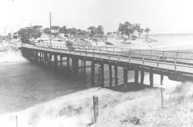 Chelsea & District Historical Society Inc
Photograph - Patterson River, Rail and Road Bridge, c 1910
... the mouth of the river. ..., Carrum near the mouth of the river. Rail and Road Bridge ...The first bridge over the river was built in the early 1880's, prior to this it was a pontoon bridge.Black and white photo of the wooden road bridge (Point Nepean / Nepean Highway), over Patterson River, Carrum near the mouth of the river. patterson river, road bridge, rail bridge, chelsea, transport, patterson river bridge, carrum bridge -
 Chelsea & District Historical Society Inc
Photograph - Patterson River, Rail and Road Bridge
... River. Taken from the mouth of the river.... of the Patterson River. Taken from the mouth of the river. Rail and Road ...The first bridge over the river was built in the early 1880's, prior to this it was a pontoon bridge.Black and white photo of the road bridge (Point Nepean / Nepean Highway) and rail bridge, near the mouth of the Patterson River. Taken from the mouth of the river.patterson river, road bridge, rail bridge, chelsea, transport, patterson river bridge, carrum bridge -
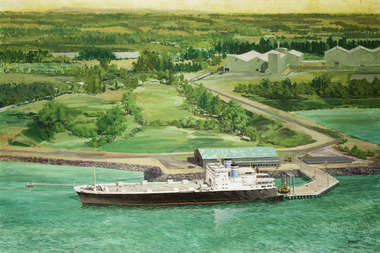 Mission to Seafarers Victoria
Painting - Painting, Acrylic, Ramon Honisett, Untitled, 1990-2000
... or river mouth. The middle ground shows a moderate solid jetty... or river mouth. The middle ground shows a moderate solid jetty ...Ramon (Ray) Francis Honisett (11.04.1931 - 30.08.2019), Fellow RMIT and medallist specialised in philatelic design, marine and military aircraft painting art and was active in the 1960s - 1990s. Ray Honisett used to live in Rye, in the Mornington Peninsula. According to Gavin Fry's book: The painting likely depicts the Lysaght Endeavour loading at Hastings. "The Lysaght Endeavour and its sister ship Lysaght Entreprise were built in Newcastle in 1973 specifically to serve the regional steel industry on the route Port Kembla - Westernport - Adelaide. Even after being lengthened by 17 metres, the two ships had remarkably short working lines, with both being broken up by 1988."Maritime artLarge framed unglazed landscape format painting predominantly green depicting in foreground a merchant vessel, a roll-on roll-off cargo ship moored at a single quayside on a river or river mouth. The middle ground shows a moderate solid jetty leading to large storage sheds at right. The background appears primarily rural with fields and hills in the distance. The location is probably Hastings Western Port in Victoria - notice the forklifts loading rolls of steel produced at the nearby steel rolling mill - the buildings in the distance. You can see the rolls of steel lined up on the hard stand to the right of the ship. The funnel colours suggest the Australian National Line. The frame incorporates a beige fabric slip with gilt edge the actual dark wood frame also with inset banded gilt edge. The back of the painting is covered with brown paper in places damaged. Hangs on a cotton cord threaded between two screw in eyelet hooks.at lower right corner single uc word in black paint : "HONISETT"tankers, marine painting, maritime art, ramon honisett, ray honisett, anl maritime art prize, acta maritime art prize, hastings, western port, victoria, steel, roll on roll off, forklift, mornington peninsula, artwork-paintings -
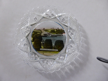 Warrnambool and District Historical Society Inc.
Platter, Transfer Hopkins River
... features a colour illustration of the Hopkins River, Warrnambool... illustration of the Hopkins River, Warrnambool (near its mouth ...This is a souvenir dish or small plate with an illustration of the Hopkins River in Warrnambool. Included in the illustration are the rowing shed, the boathouses and the lambertiana trees in the property of Lyndoch. The souvenir dish would have been sold to tourists visiting Warrnambool or Warrnambool residents in the 1920s and 30s. This type of souvenir was popular at the time in any tourist town or place in Australia. Tourism has been an important industry in Warrnambool since the late 19th century. This item is of interest as an example of the type of souvenir produced for tourists in the 1920s and 30s. It was both a useful and decorative item. It will be useful for display. This is a small glass souvenir dish. The centre of the dish features a colour illustration of the Hopkins River, Warrnambool (near its mouth). The glass around the illustration is heavily patterned and embossed. The bottom of the dish is dark blue. ‘Hopkins River Warrnambool’ tourism in warrnambool, warrnambool history -
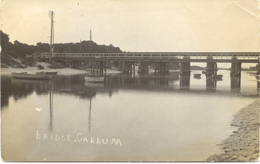
 Chelsea & District Historical Society Inc
Photograph - Patterson River Postcards, Rail and Road Bridge, c 1905
... , with a steam train crossing over Patterson River, near the mouth... , with a steam train crossing over Patterson River, near the mouth ...The first bridge over the river was built in the early 1880's, prior to this it was a pontoon bridge. Dr. Sheldon's Magnetic Liniment was advertised as being able to relieve "at once rheumatism, lumbago, lame back, cuts, bruises or burns, will effect a cure in a remarkably short time. Price 1s 6d and 3s"Two postcards of the road bridge (Nepean Highway) with a horse and cart and people crossing and single line rail bridge , with a steam train crossing over Patterson River, near the mouth of the river. One card has been coloured, the other has been modified to advertise Dr Sheldon's Magnetic Liniment.DR SHELDON'S NEW DISCOVERY 16' & 3' BANISHES ALL PAINS AT CARRUM VICTORIApatterson river, road bridge, rail bridge, dr sheldon's linament, chelsea, steam train, transport, chelsea bridge, patterson bridge -
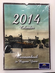 Warrnambool and District Historical Society Inc.
Calendar, Warrnambool in Bygone Years, 2013
... Pavilion and the Hopkins River near the mouth. The photographs... and the Hopkins River near the mouth. The photographs in the calendar come ...This 2014 calendar was produced in Warrnambool and features reproductions of photographs of Warrnambool in past times. The photographs include the Botanic Gardens, the Breakwater, the War Memorial, Proudfoots Boatsheds, Liebig Street, the old Information Pavilion and the Hopkins River near the mouth. The photographs in the calendar come from the collection of the Warrnambool and District Historical Society and were reproduced with the permission of the Society. This calendar is of minor importance but it does demonstrate the popularity of locally-produced yearly calendars and the interest in photographs of times gone. This is a 2014 calendar featuring twelve photographs of Warrnambool in past times. The photographs have been coloured or tinted and the front cover has a copy of the photograph featured for the month of March. The front cover has a brown edging and the inside front cover and the black cover are white. The dates are printed in two colours and vary from month to month. The paper is glossy and the pages have been bound with plastic spiral binding with a tab at the top to append the calendar to a wall. ‘2014 Calendar’ ‘Warrnambool in Bygone Years’ warrnambool photographs of the past, calendar 2014, spectrum print solutions -
 Chelsea & District Historical Society Inc
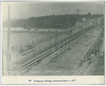
Photograph - Patterson River, Temporary and Old Bridge, c 1927
... River, Carrum near the mouth of the river. Cars using the old... River, Carrum near the mouth of the river. Cars using the old ...The first bridge over the river was built in the early 1880's, prior to this it was a pontoon bridge. In 1927 the construction of a concrete bridge was undertaken.Black and white photo of the old wooden road bridge (Point Nepean / Nepean Highway), and a temporary bridge over Patterson River, Carrum near the mouth of the river. Cars using the old bridge. Rowing boats on shore. Temporary and old bridge, Carrumpatterson river, road bridge, rail bridge, chelsea, transport, patterson river bridge, carrum bridge, temporary bridge, cars -
 Flagstaff Hill Maritime Museum and Village
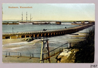
Postcard - Historical, maritime, Breakwater, Warrnambool, ca. 1890
... the Merri River near its mouth, the Viaduct road and the Warrnambool... the Merri River near its mouth, the Viaduct road and the Warrnambool ...The local photograph shows the original footbridge across the Merri River near its mouth, the Viaduct road and the Warrnambool Breakwater with the Titan crane on it. The breakwater's construction was completed in 1890, the year this photograph was taken. The Viaduct has since been filled in to prevent water from passing through the pylons, and the footbridge has been replaced. The postcard has a personal message written on the back to a Dr Scott from May. The photograph is locally significant for recording the completion of the Warrnambool Breakwater, for showing the original design of the Viaduct and for a clear view of the original footbridge across the Merri River. It is also of significance for being used by a female to send a greeting from Warrnambool to a doctor. Postcard, coloured, of the Warrnambool Breakwater, with the Merri River footbridge and the Viaduct in the foreground. Pedestrians and a horse-drawn cart are on the Viaduct, The lifeboat house and other buildings are near the beginning of the Breakwater. A three-masted sailing ship is in port. The photograph was taken from Middle Island. A personal message is written on the back, and a title is printed on the front. Produced in Germany in the 1890s.On the front: "Breakwater, Warrnambool" Written on the reverse: "Warrnambool Wishing Dear Dr Scott the Compliments of the Season With love and best wishes, From May"warrnambool, shipwreck coast, flagstaff hill, flagstaff hill maritime museum, flagstaff hill maritime village, postcard, coloured postcard, warrnambool breakwater, breakwater, viaduct, 1890s, merri river footbridge, dr scott, may -
 Warrnambool and District Historical Society Inc.
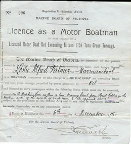
Document, Licence Motor boatman, 1918
... of the Hopkins River near the mouth and to carry passengers... on the western side of the mouth of such river to the opposite shore, 6th... on the western side of the mouth of such river to the opposite shore, 6th ...This is a licence issued to Leslie Palmer in 1918. It gives him authority to operate a motor boat across the banks of the Hopkins River near the mouth and to carry passengers. As there is a bridge at the mouth of the river it is assumed that this motor boat was used to go across the river from a private house, making it more convenient than going by road to cross the bridge. It was, and still is, a common practice to use boats to cross the river from private homes built along the banks of the Hopkins River.This is a significant item as it is an original certificate and is interesting because the licence was a restricted one, for use only in crossing the Hopkins River. This is a paper licence issued by the Marine Board of Victoria in 1918. The certificate has printed material and entries written in black ink. It has the seal of the Marine Board and the signature of the SecretaryWritten material: ‘Leslie Alfred Palmer of Warrnambool, oil, on the Hopkins River within a line bearing east from Point Ritchie on the western side of the mouth of such river to the opposite shore, 6th December 1918’ motor boat licence 1918, warrnambool, leslie palmer, hopkins river -
 Flagstaff Hill Maritime Museum and Village
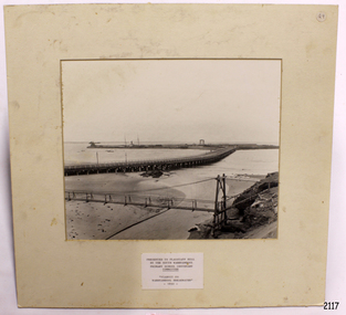
Photograph - Coastal Scene, Warrnambool South Primary School Centenary Committee, Viaduct to Warrnambool Breakwater - 1890, 1977
... the Merri River near its mouth, the Viaduct road and the Warrnambool... footbridge across the Merri River near its mouth, the Viaduct road ...The local photograph shows the original footbridge across the Merri River near its mouth, the Viaduct road and the Warrnambool Breakwater with the Titan crane on it. The breakwater's construction was completed in 1890, the year this photograph was taken. The Viaduct has since been filled in to prevent water passing through the pylons, and the footbridge has been replaced. The photograph was presented to Flagstaff Hill on the centenary of South Warrnambool Primary School, 1877 to 1977, by the school's Warrnambool South Primary School Centenary Committee. The centenary was celebrated during August 12-13-14. The school was decommissioned in the 1990s.The photograph is locally significant for recording the completion of the Warrnambool Breakwater, for showing the original design of the Viaduct and for a clear view of the original footbridge across the Merri River. It also records the date of the presentation of the photograph celebrates the centenary of the 1877 to 1977 Warrnambool Sough Primary School.Photograph, black and white, mounted onto cardboard with a pasted-on label below the photograph. It shows the Merri River footbridge, the Viaduct, the Warrnambool Breakwater with the Titan crane, and the Port of Warrnambool. The label has an inscription. The photograph was taken in 1890 and was presented to Flagstaff Hill by the South Warrnambool Primary School's Centenary Committee ca. 1977. The photograph was taken in 1890 and was presented to Flagstaff Hill Maritime Museum by the South Warrnambool Primary School Centenary Committee in the Centenary year of the South Warrnambool Primary School;1977.Typed onto the label: "PRESENTED TO FLAGSTAFF HILL / BY THE SOUTH WARRNAMBOOL / PRIMARY SCHOOL CENTENARY / COMMITTEE / "VIADUCT TO / WARRNAMBOOL BREAKWATER" / - 1890 - "warrnambool, shipwreck coast, flagstaff hill, flagstaff hill maritime museum, flagstaff hill maritime village, warrnambool breakwater, viaduct, viaduct road, merri river bridge, merri footbridge, original merri foodtridge, titan crane, warrnambool south primary school, warrnambool south primary school centenary commitee, centenary committee, 1890, 1877, 1877-1977, lady bay, port of warrnambool -
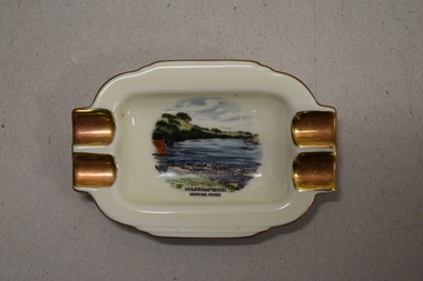 Warrnambool and District Historical Society Inc.
Ashtray, Alka Kunst, Warrnambool Hopkins River, c. 1960
... holiday. The image on the dish shows the Warrnambool Hopkins River.... The image on the dish shows the Warrnambool Hopkins River near its ...This item was bought as a souvenir of Warrnambool in the mid 20th century when cigarette smoking was more widespread and was socially acceptable. Tourism in Warrnambool has been an important industry for over 100 years. In the late 19th century Warrnambool was promoted as a spa resort with its mild climate, sea bathing and its hot and cold sea water baths complex. Today visitors come in winter for the May Racing Carnival and to see the Southern Right whales at Logans Beach and in summer they come for a beach holiday. The image on the dish shows the Warrnambool Hopkins River near its mouth. The boatshed is no longer there with sections of the building being relocated to a site in Henna Street and used for indoor recreational purposes.This ash tray is retained as an example of a local tourist souvenir sold to tourists in the 1960s. This is a small white china dish made in an oval shape and slightly raised from the surface on which it sits. The ends of the dish have four gold coloured indents for stubbing cigarettes. There is a gold rim around the edge of the dish and a coloured image of the old boat shed and jetty on the Hopkins River in Warrnambool. On the base of the dish is the logo of the maker and printed details.Warrnambool Hopkins River Alka Kunst Bavaria tourism in warrnambool, history of warrnambool