Showing 107 items
matching river moyne
-
 Ballarat Heritage Services
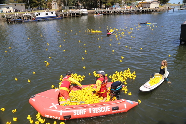
Digital photographs, L.J. Gervasoni, Moyneyana New Years Day Duck Race, 2015, 2015
... Moyne River, Port Fairy, Moyne Shire, Victoria, Australia... victoria moyne river duck race rubber ducks Digital images ...Digital images of the Moyneyana New Years Day Duck Race.moyneyana, festival, port fairy, port, fairy, victoria, moyne, river, duck, race, rubber ducks -
 Ballarat Heritage Services
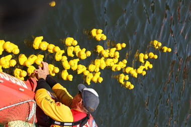
Digital photographs, L.J. Gervasoni, Moyneyana ducks, c2013
... moyne river...Moyne River, Port Fairy, Moyne Shire, Victoria, Australia... slsc surf life saving club port fairy rubber ducks moyne river ...landscape, river, moyneyana, duck race, fundraiser, slsc, surf life saving club, port fairy, rubber ducks, moyne river -
 Port Fairy Historical Society Museum and Archives
Photograph
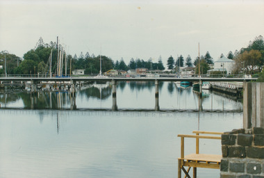
... moyne river...Moyne River Footbridge...Coloured photograph of the Moyne river taken from the West... Street Port Fairy great-ocean-road Moyne River Footbridge moyne ...Moyne River FootbridgeColoured photograph of the Moyne river taken from the West side of the footbridge looking to the wharfmoyne river, foot bridge, jetties, wharf, boats -
 Port Fairy Historical Society Museum and Archives
Photograph
... moyne river...Moyne river bridge photograph taken in 1956 showing...Coloured landscape of the Moyne River bridge taken from... Street Port Fairy great-ocean-road Moyne river bridge photograph ...Moyne river bridge photograph taken in 1956 showing Blakes caravan park in backgroundColoured landscape of the Moyne River bridge taken from the balcony of the house (Riverside) on the corner of Regent Street and Gipps street From Tom Bartlett's Gipps Street looking East over bridge 1956bridge, moyne river, traffic, gipps street -
 Port Fairy Historical Society Museum and Archives
Photograph, 1905
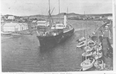
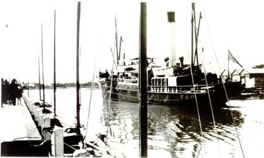
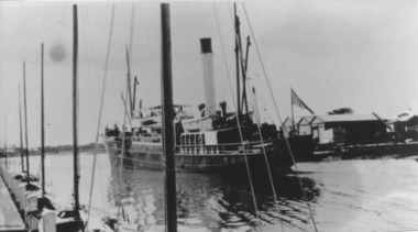
... B&W Photograph Iron Steamship SS Casino in the Moyne River...Moyne River, Port Fairy, Victoria, Australia... in the Moyne River Photograph Photograph ...B&W Photograph Iron Steamship SS Casino in the Moyne Rivership, boat, sea, river, iron steamship ss casino -
 Port Fairy Historical Society Museum and Archives
Photograph, C. 1925
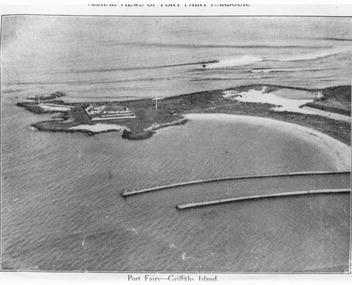
... moyne river...Black and white arial photograph of the Moyne river...Hand written on the back "Port Fairy Moyne River Entrance R... photograph of the Moyne river entrance, the original signed ...Black and white arial photograph of the Moyne river entrance, the original signed by R.W.Golding.Black and white aerial photograph of Griffith island showing the lighthouse keeper’s compound, the large flagstaff and the river training walls in the foregroundHand written on the back "Port Fairy Moyne River Entrance R. W. Golding Handwritten on the back of the copy "Port Fairyb Harbour 1925"local history, photography, photographs, slides, film, arial, moyne river -
 Port Fairy Historical Society Museum and Archives
Photograph
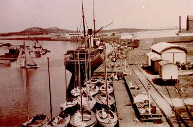
... moyne river...Moyne River wharf, Port Fairy, Victoria, Australia... Street Port Fairy great-ocean-road fishing vessels moyne river ...Black & white photograph of Couta boats moored around ship at wharffishing vessels, moyne river -
 Port Fairy Historical Society Museum and Archives
Photograph, Friendship
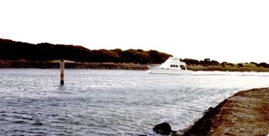
... moyne river...Moyne River, Port Fairy, Victoria, Australia... Street Port Fairy great-ocean-road pleasure craft moyne river ...Colour photographpleasure craft, moyne river, boating -
 Port Fairy Historical Society Museum and Archives
Photograph
... Moyne River, Port Fairy, Victoria, Australia... moyne Black & white photograph of ship in river Photograph ...Coastal steamer sank at Apollo Bay in 1932 Iron Steamship SS Casino Black & white photograph of ship in rivership, sea, river, ss casino, moyne -
 Flagstaff Hill Maritime Museum and Village
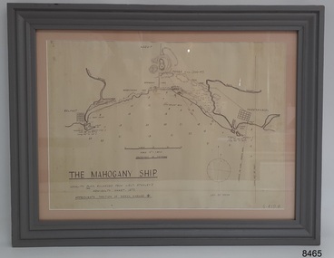
Document - Location Chart, The Mahogany Ship, 2007
... Moyne River... MOYNE" "RIVER MERRI" "ARMSTRONG BAY" " GORMANS LANE" "TOWER HILL... River Moyne River Middle Island Helen Rock Armstrong Bay ...This chart shows a possible site for the fabled wreck called the 'Mahogany Ship'. Flagstaff Hill’s collection includes other objects that some say could be relics from this Ancient Wreck, (also called the Gold Ship, or the Ancient Vessel). The chart shows the coordinates for the Summits of Griffith Island and of Middle Island. It also has the depths of the sea at various intervals and shows the shore and sand dunes, lighthouses and other reference points. The mystery of the Mahogany Ship began in 1836 when two shipwrecked sealers discovered the remains of an “ancient vessel” in the sand dunes about four miles west of Warrnambool. Since the last recorded sightings in the 1880’s the true origin of the Mahogany Ship has remained one of Australia’s most famous historical mysteries or fables. One of the more recent theories is that the vessel was one of the Portuguese ships exploring the Australian coast in 1522. For over one hundred years searchers have attempted to locate and identify the wreck. The search continues for the tangible evidence which will once and for all establish the Mahogany Ship’s place in Australia’s History.The chart represents the worldwide interest in locating the wreck of the Mahogany Ship. Locating the actual wreck or proving the existence of a Portuguese ship's wreck could change the history of the discovery of Australia. A Mahogany Ship committee was formed to gather and research information about the discovery of the wrecked ship. A large amount of money was offered as a prize for finding the wreck or parts of it. People have written books, painted images, made videos and told tales of the ship but it continues to remain a mystery or even a fable. The chart is significant for its possible link to one of Victoria’s and Australia’s maritime mysteries, the Mahogany Ship (also known as the Ancient Wreck). It is one of very few known relics that could give evidence of the existence and history of the vessel. It is listed on the Victorian Heritage Register S438 as it is one of Victoria’s oldest recorded shipwrecks. The identity of the vessel has the potential to change Australia’s history.A chart in a wooden frame, behind glass. The chart shows the approximate position of the mystery Ancient Wreck, later called the "Mahogany Ship". The chart is a copy and is based on the Admiralty Chart by Lieut. Stanley, dated 1872. Lower left: "THE MAHOGANY SHIP" "LOCALITY PLAN, ENLARGED FROM LIEUT. STANLEY'S ADMIRALTY CHART 1872" "APPROXIMATE POSITION OF WRECK MARKED [symbol of a Portuguese cross]" Other labels on chart: "BELFAST" "PORT FIARY" "GRIFFITHS I" "RIVER MOYNE" "RIVER MERRI" "ARMSTRONG BAY" " GORMANS LANE" "TOWER HILL" "KOROIT" "HELEN ROCK" "WARRNAMBOOL" "LADY BAY" "MIDDLE I" "LIGHT HO." Lower right: "G 410 B" Label on the back; "This chart presented to the Mahogany Ship Committee and Flagstaff Hill by Avis Quarrell, April 2007"warrnambool, shipwrecked coast, flagstaff hill maritime museum, shipwreck coast, mahogany ship, ancient vessel, ancient wreck, portuguese ship, coastal reserve, fabled wreck, gold ship, griffiths island, belfast (now port fairy), koroit, location plan, leuit. stanley, admiralty chart 1872, tower hill, merri river, moyne river, middle island, helen rock, armstrong bay, griffiths land -
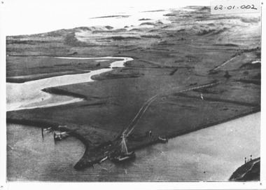
 Port Fairy Historical Society Museum and Archives
Photograph - photograph-mounted, R.W.Golding, 1925
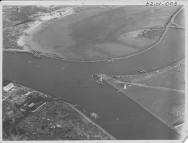
... moyne river...Martins's Point Moyne River... R.W.Golding aerial view martin's point moyne river r.w.golding flight ...Flight taken in 1925 by Mr R.W.Golding Black and white aerial PhotographMartins's Point Moyne Riveraerial view, martin's point, moyne river, r.w.golding, flight -
 Port Fairy Historical Society Museum and Archives
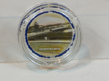
Souvenir - ashtray
... moyne river...Moyne River, Port Fairy... over the Moyne River Port Fairy circa 1940. glass ashtray port ....Photograph of the bridge over the Moyne River Port Fairy circa 1940.Round, glass ashtray.Moyne River, Port Fairyglass, ashtray, port fairy, photograph, moyne river -
 Port Fairy Historical Society Museum and Archives
Photograph
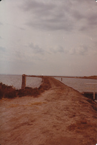
... moyne river...Coloured photograph of Left training wall on Moyne river... Training wall east beach moyne river Coloured photograph of Left ...training wall East sideColoured photograph of Left training wall on Moyne rivertraining wall, east beach, moyne river -
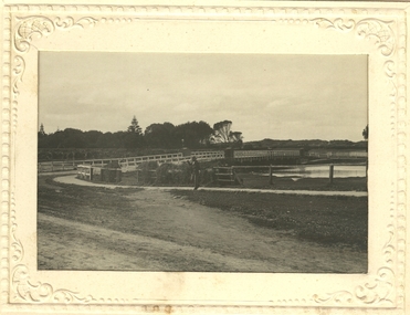
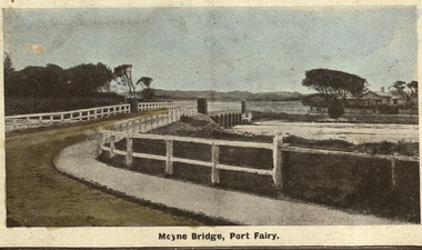
 Port Fairy Historical Society Museum and Archives
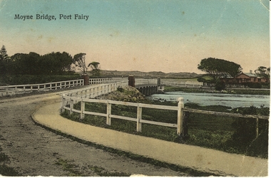
Photograph - Postcard, Moyne Bridge, Port Fairy
... Hand tinted photograph of Moyne river road bridge taken...Moyne River, Port Fairy... Street Port Fairy great-ocean-road moyne bridge 1910 river road ...Hand tinted photograph of Moyne river road bridge taken looking East showing house on Griffith street on the right side in the background taken for use as a PostcardMoyne River, Port Fairymoyne bridge, 1910, river, road, gipps street -
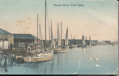
 Port Fairy Historical Society Museum and Archives
Photograph - newspaper photograph
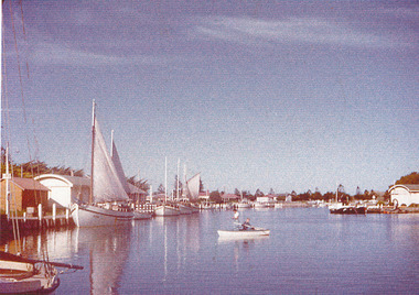
... Moyne river...Moyne river ... Street Port Fairy great-ocean-road Moyne river Moyne river Boats ...Moyne river moyne river, boats, sails -
 Port Fairy Historical Society Museum and Archives
Photograph
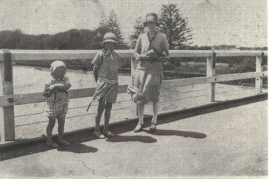
... moyne river...Family standing on Moyne River bridge... Street Port Fairy great-ocean-road Family standing on Moyne River ...Family standing on Moyne River bridgeBlack and white family photograph bridge, moyne river, famiily, children, mother, traffic, car -
 Port Fairy Historical Society Museum and Archives
Photograph
... moyne river... of the West side of the traffic bridge over the Moyne river Postcard... gipps street traffic moyne river Black and white photograph ...Moyne BridgeBlack and white photograph in an embossed card frame of the West side of the traffic bridge over the Moyne river Postcardmoyne bridge, gipps street, traffic, moyne river -
 Port Fairy Historical Society Museum and Archives
Photograph
... moyne river...Martin's Point from battery hill side of Moyne river... hill side of Moyne river Martins point moyne river fence Signal ...Martin's Point from battery hill side of Moyne riverColoured photograph of Martins Point with people fishing on the bankmartins point, moyne river, fence, signal -
 Port Fairy Historical Society Museum and Archives
Photograph - Postcard, Moyne bridge
... moyne river...Photograph hand tinted of the Moyne river road bridge taken... Street Port Fairy great-ocean-road moyne bridge 1910 moyne river ...Photograph hand tinted of the Moyne river road bridge taken from Gipps Street showing house on the far bank on the right side taken for use as a PostcardMoyne Bridgemoyne bridge 1910, moyne river, traffic, gipps street -
 Port Fairy Historical Society Museum and Archives
Photograph, c. 1925
... moyne river...Black and white aerial of Martins Point Moyne River... of Martins Point Moyne River showing dredge. The original signed by R ...Black and white aerial of Martins Point Moyne River showing dredge. The original signed by R. W. Golding.Black and white landscapelocal history, photography, photographs, slides, film, aerial, martins point, moyne river, dredge -
 Peterborough History Group
Newspaper articles pertaining to Peterborough from 1990 to 1999
... Ronald Irvine Curdies River Moyne Council council boundary ...Various newspaper articles kept by Mrs Dawn Irvine, all pertaining to Peterborough - river flooding and quality, concerns over council boundary realignment. Article titles: 6/10/1992 Flooding at Peterborough 28/6/1994 Residents undecided over River 4/7/1994 Letter from Warren Moore. Peterborough is alive, the way residents like it. 26/12/1994 Letter from R. Irvine. Apprehension over changes 17/6/1998 Algae fear prompts call to open Curdies River 13/4/1999 Battlelines on the Curdies 14/4/1999 Peterborough residents urge BHP to find alternative waste disposal optionHistoric overview of the towns' concerns at that time. Seven newspaper cuttings of various sizes all regarding aspects of Peterborough. Includes objection to BHP discharging waste into the Curdies River and flooding. warren moore, ronald irvine, curdies river, moyne council, council boundary realignment, curdies river flooding, floods, peterborough, blue green algae, river quality, bhp waste management, bhp -
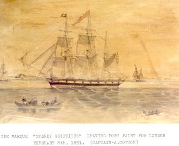 Port Fairy Historical Society Museum and Archives
Photograph, Barque Sydney Griffiths, 1851
... Moyne River, Port Fairy, Victoria, Australia ...Barque built in Launceston by Jonathon Griffiths Bet.1827-1850Sepia photographThe Barque Sydney Griffiths leaving Port Fairy for London 8th February 1851 Captain J Cowton barque, passenger ship -
 Port Fairy Historical Society Museum and Archives
Photograph
... Moyne River wharf, Port Fairy, South West, Victoria ...S.s.Casino moored at the Belfast and Koroit Steam Navigation Company wharf in Port FairyBlack & white photograph of ship at wharfship, boat, sea, river, ss casino -
 Port Fairy Historical Society Museum and Archives
Photograph
... Moyne River, Port Fairy, Victoria, Australia ...SS HellenicBlack & white photographship, boat, sea, river -
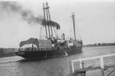 Port Fairy Historical Society Museum and Archives
Photograph, TSS Coramba with record wool cargo
... Moyne River, Port Fairy, Victoria, Australia ...Owned by the Belfast & Koroit Steamship Co. Used primarily for shipping freight between Port Fairy and Melbourne, the Coramba was lost off Phillip Island during a storm on 30th November 1934. Her location was not discovered until 29th May 2011B&W photographship, boat, sea, river -
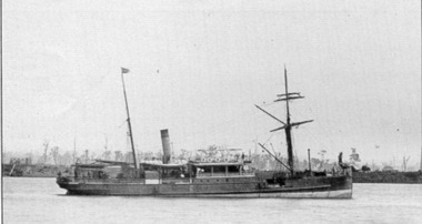
 Port Fairy Historical Society Museum and Archives
Photograph, Iron Steamship SS Casino, 1932
... Moyne River, Port Fairy, Victoria, Australia ...Coastal steamer sank at Apollo Bay in 1932B&W photographship, sea, river, ss casino -
 Flagstaff Hill Maritime Museum and Village
Photograph - S. S. Casino, Early 19th century
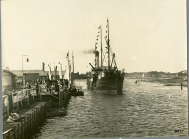
... Wharf and Moyne River, Port Fairy, Great Ocean Road ...This photograph was one of ten photographs donated to Flagstaff Hill Maritime Museum and Village by Fred Trewartha. Frederick John Fox Trewartha (Fred) was a well-known Warrnambool businessman. He was born in Beeac near Geelong in 1920 and came to Warrnambool with his family as a very young child. He was apprenticed to his father John, as a saddler and later opened his own shop on Raglan Parade. He then moved into working with tarpaulins and canvases for the trucking industry. Fred was keenly interested in photography (and was a member of the Warrnambool Cine Club), yachting and boat building. He kept his yacht moored at Port Fairy for many years and participated in sailing events locally and interstate. He also built boats with his sons. He had the opportunity to meet many older sailors and it's thought this photo (and others in the set) may have been given to him by one of these men. Fred Trewartha died in 2016 in Warrnambool. The S.S. Casino was a passenger and freight steamer built in Dundee, Scotland, in 1882 for the Newcastle and Hunter River Steam Navigation Company of N.S.W. She weighed 425 tons gross with a length of 160.4 feet, beam of 24.1 feet and a depth of 10.2 feet. She had saloon accommodation for 35 people, a fore cabin for 25 more people, and she carried 300 tons of cargo. While on her delivery journey on May 30th 1882, the S.S. Casino called in at the Port of Warrnambool for coal, narrowly escaping going ashore in gale force winds due to the quick action of the pilot. At that time, still at anchor, she impressed the directors of the Belfast and Koroit Steam Navigation Company so much that they bought her immediately; she was ideal for trade along the West Coast of Victoria. (The Belfast and Koroit Steam Navigation Company was first managed by Messers. Saltau and Osburne and after the passing of Mr. Osburne, by produce merchants Messers H. Sautau and Sons, who had a hay and corn store and shipping agency on the corner of Liebig and Koroit Streets in Warrnambool. ) The S.S. Casino became “the most famous steamer to operate in Victorian waters along the West Coast” by author Jack Loney. Captain Boyd was her first Master, followed by Captain Chapman, who stayed with her from 1890 until 1924. Captain W. Robertson followed for a short term, and then Captain Middleton then took command from 1925 - 1932. An article published on Monday 11th June 1932 in The Sun News Pictorial (Melbourne) giving a detailed history of S. S. Casino said "owned by Port Fairy interests, she was an integral part of the town's development ... for a long time, her arrival in Port Fairy was an event, the townspeople going down to the wharf to see her come in". It also said "Except when the weather was bad, the Casino hugged the coast on her trips and passengers obtained wonderful views of the sandstone terraces and caves. A little time ago every member of her regular crew except one, was a Scotsman." This particular photograph of the S.S. Casino shows it decorated with numerous flags in "holiday rigging". During the years between 1884 and 1915, the Casino would take locals and holiday makers on excursions around the Port Fairy Bay. Local towns such as Terang, Penshurst and Mortlake held their Picnic Days in Port Fairy and excursions on the Casino would be available for them and in 1906 Terang and District Schools held an excursion to Port Fairy (where the Casino was organised to provide a series of trips around the Bay.) In 1916 new regulations introduced by the Marine Board requiring the Casino to carry enough lifebelts for every passenger on board, prevented the steamer from making trips around the Bay on excursion days. The S.S. Casino had several mishaps during her life. One was on 3rd January 1898 when she collided with the S.S. Flinders in Apollo Bay with minor damage. Another was on 24th October 1924 when she grounded on a reef at Point Hawdon near Grey River and most of her cargo (of Christmas goods) had to be dumped into the sea. Then in February 1929 she was ‘holed’ when she struck a submerged object as she entered Lady Bay, Warrnambool. In the years following the turn of the century, the S.S. Casino remained the only regular trader with normal passenger accommodation along the West Coast. From 1882 she had made at least 2,500 voyages on the one run. On the morning of 10th July 1932, after attempting to berth at Apollo Bay jetty in heavy seas, Captain Middleton decided to take her out into the bay and wait until the seas abated. It was not realised that the anchor used to steady her as she manoeuvred to her berth had pierced her hull. She put about and headed for the beach but sank. Captain Middleton and nine others lost their lives; nine people were rescued including the two female passengers. Captain Middleton had been in charge of the S.S. Casino for seven years. He was the first ship’s Master to lose his life in a shipwreck in the West Coast trade. In June 1932, the directors of the Belfast and Koroit Steam Navigation Company had proposed to celebrate the completion of fifty years of trading by the steamer Casino in August, but tragically the Casino was wrecked only one month later (and "was only one month off completing its fifty years of valuable service between Melbourne and Portland.") Flagstaff Hill’s collection has a photograph of a portrait of Captain Chapman, a ship model of the S.S. Casino that shows both forms of power under which she sailed, steam and sail. The ship is painted green and flies three flags. The inscription across the case of the ship model, incorrectly dated, tells the sad story of the wreck of the ship and the loss of lives on July 10th 1932 at Apollo Bay. A print in the Collection shows S.S. Casino underway in the heavy sea off Point Lonsdale, another two photographs show her at the Port of Warrnambool, leaving from the Breakwater in Lady Bay and another identifies the S.S. Casino as a ship from the Belfast and Koroit Steam Navigation Company. (Belfast is the original name for the township of Port Fairy).This photograph is significant because of its association with the coastal trader S.S. Casino and its significance to trade along Victoria's West Coast in the late 19th and early 20th centuries. The wreck of the S.S. Casino is considered an important part of Victorian and Australian cultural heritage and as such has been declared and protected as an Historic Shipwreck under State and Commonwealth Law in the Commonwealth Historic Shipwrecks Act (1976).A black and white photograph showing a small steamer with decorative flags on both masts, coming into up a river towards a pier where a small crowd is waiting. The pier on the left of the photograph has several buildings and a bell on it. Three small boats are tied up to the dock. Low lying land with several buildings scattered on it can be seen on the right hand side. On the back of the photograph are handwritten labels. One is printed in dark blue ink and one is written in cursive writing in biro. There is also the number 6944 stamped in the centre of the photograph.Back - Donors name, address and telephone number 6944 "CASINO IN HOLIDAY RIG" "at Port Fairy"flagstaff hill maritime museum and village, warrnambool, great ocean road, shipwreck coast, s. s. casino, steamer casino, casino, port fairy, captain chapman, belfast and koroit steam navigation company, saltau and osburne, captain middleton, apollo bay, apollo bay shipwreck, lady bay -
 Port Fairy Historical Society Museum and Archives
Photograph, HMAS Yarra
... moyne river... at the Moyne river wharf ship boat sea river Hmas yarra moyne river ...H.M.A.S. Yarra on goodwill visit to Port Fairy 1921A rare image of a war ship anchored at the Moyne river wharfBlack& White photographship, boat, sea, river, hmas yarra, moyne river -
 Port Fairy Historical Society Museum and Archives
Photograph
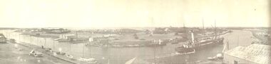
... Black and white panoramic photograph of the Moyne river... Black and white panoramic photograph of the Moyne river ...Black and white panoramic photograph of the Moyne rivership, boat, sea, river, ss casino -
 Port Fairy Historical Society Museum and Archives
Postcard - Photograph, A.C. Aberline, Fishing boats in Mayne River
... Moyne River Port Fairy... fishing town and tourist meca harbour fishing fleet Moyne River ...Shows the fishing fleet in the harbour this postcard was used to send a message home to family and friends regarding their stay in Port FairyA photograph of a busy fishing town and tourist mecaHand coloured photograph/postcardMoyne River Port Fairyharbour, fishing fleet