


Historical information
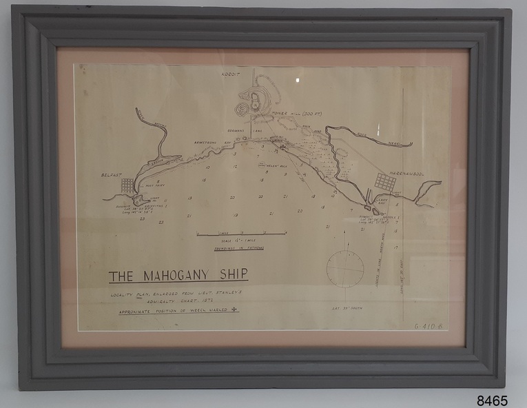
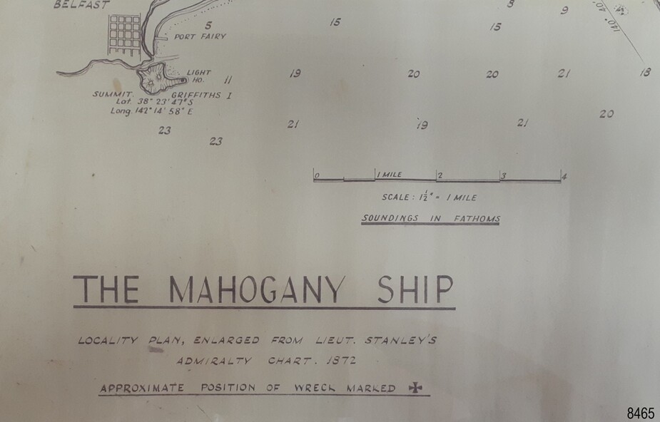
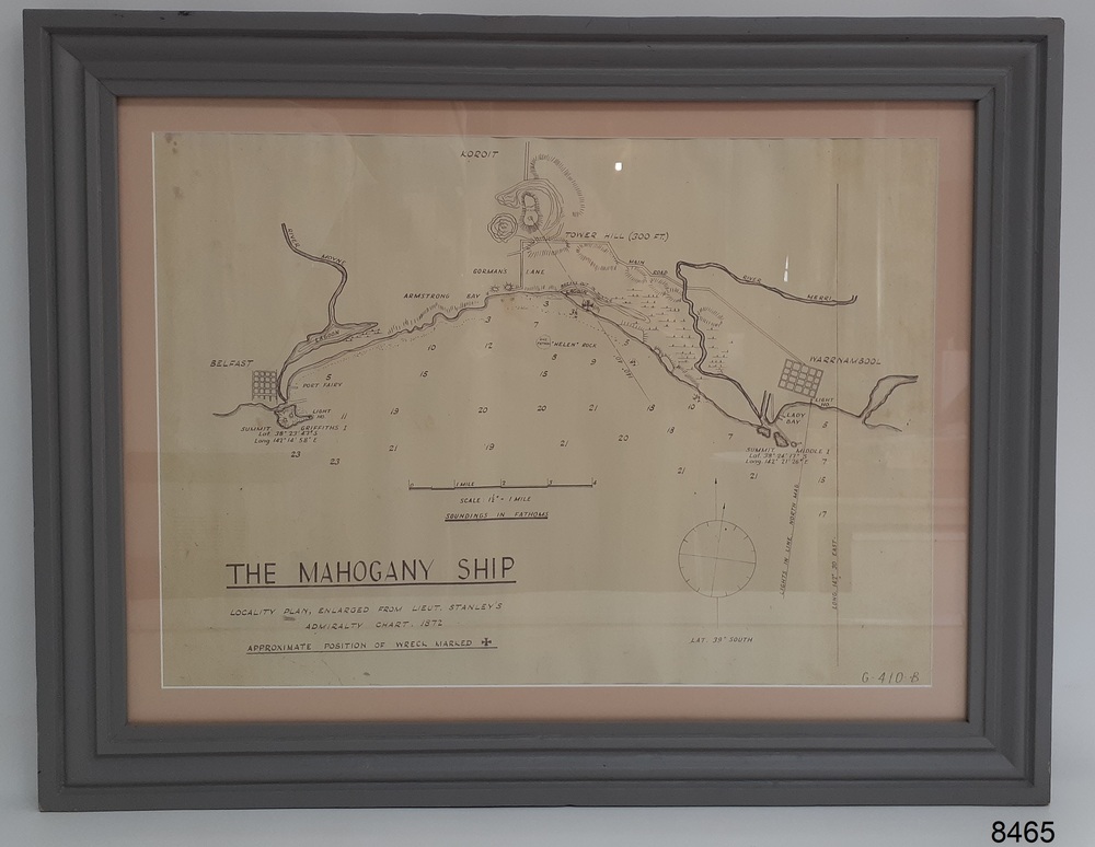
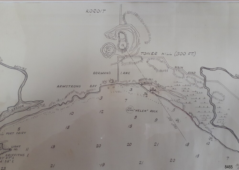
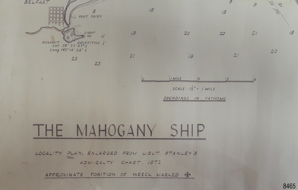
This chart shows a possible site for the fabled wreck called the 'Mahogany Ship'. Flagstaff Hill’s collection includes other objects that some say could be relics from this Ancient Wreck, (also called the Gold Ship, or the Ancient Vessel). The chart shows the coordinates for the Summits of Griffith Island and of Middle Island. It also has the depths of the sea at various intervals and shows the shore and sand dunes, lighthouses and other reference points.
The mystery of the Mahogany Ship began in 1836 when two shipwrecked sealers discovered the remains of an “ancient vessel” in the sand dunes about four miles west of Warrnambool. Since the last recorded sightings in the 1880’s the true origin of the Mahogany Ship has remained one of Australia’s most famous historical mysteries or fables. One of the more recent theories is that the vessel was one of the Portuguese ships exploring the Australian coast in 1522.
For over one hundred years searchers have attempted to locate and identify the wreck. The search continues for the tangible evidence which will once and for all establish the Mahogany Ship’s place in Australia’s History.
Significance
The chart represents the worldwide interest in locating the wreck of the Mahogany Ship. Locating the actual wreck or proving the existence of a Portuguese ship's wreck could change the history of the discovery of Australia.
A Mahogany Ship committee was formed to gather and research information about the discovery of the wrecked ship. A large amount of money was offered as a prize for finding the wreck or parts of it. People have written books, painted images, made videos and told tales of the ship but it continues to remain a mystery or even a fable.
The chart is significant for its possible link to one of Victoria’s and Australia’s maritime mysteries, the Mahogany Ship (also known as the Ancient Wreck). It is one of very few known relics that could give evidence of the existence and history of the vessel. It is listed on the Victorian Heritage Register S438 as it is one of Victoria’s oldest recorded shipwrecks. The identity of the vessel has the potential to change Australia’s history.
Physical description
A chart in a wooden frame, behind glass. The chart shows the approximate position of the mystery Ancient Wreck, later called the "Mahogany Ship". The chart is a copy and is based on the Admiralty Chart by Lieut. Stanley, dated 1872.
Inscriptions & markings
Lower left: "THE MAHOGANY SHIP" "LOCALITY PLAN, ENLARGED FROM LIEUT. STANLEY'S ADMIRALTY CHART 1872" "APPROXIMATE POSITION OF WRECK MARKED [symbol of a Portuguese cross]"
Other labels on chart: "BELFAST" "PORT FIARY" "GRIFFITHS I" "RIVER MOYNE" "RIVER MERRI" "ARMSTRONG BAY" " GORMANS LANE" "TOWER HILL" "KOROIT" "HELEN ROCK" "WARRNAMBOOL" "LADY BAY" "MIDDLE I" "LIGHT HO."
Lower right: "G 410 B"
Label on the back; "This chart presented to the Mahogany Ship Committee and Flagstaff Hill by Avis Quarrell, April 2007"
Subjects
- warrnambool,
- shipwrecked coast,
- flagstaff hill maritime museum,
- shipwreck coast,
- mahogany ship,
- ancient vessel,
- ancient wreck,
- portuguese ship,
- coastal reserve,
- fabled wreck,
- gold ship,
- griffiths island,
- belfast (now port fairy),
- koroit,
- location plan,
- leuit. stanley,
- admiralty chart 1872,
- tower hill,
- merri river,
- moyne river,
- middle island,
- helen rock,
- armstrong bay,
- griffiths land
References
- Victorian Heritage Database VHR S438 Mahogany Ship