Showing 6722 items
matching rivers
-
 Lakes Entrance Historical Society
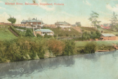
Photograph - Mitchell River Bairnsdale Victoria, 1910 c
... Rivers ...Copy of old hand coloured postcard of Mitchell River showing St Johns Church top right, rowing club boat shed bottom right with steps down to river and landing Bairnsdale VictoriaMitchell River Bairnsdale Gippsland Victoriabridges, rivers, churches -
 Greensborough Historical Society
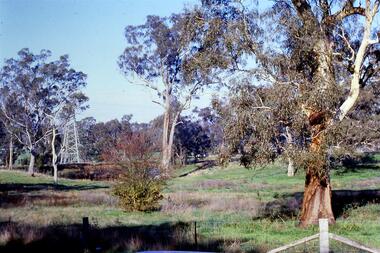
Slide - Photograph, John Ramsdale, Near the confluence of the Plenty and Yarra Rivers, Lower Plenty: Slide 118, 1990s
... Near the confluence of the Plenty and Yarra Rivers, Lower ...Photograph shows a rural scene with gumtrees and pylon. This is near the confluence of the Plenty and Yarra Rivers, Lower PlentyPart of the John Ramsdale collection of slides and audio visual material.Colour photograph scanned from slide.No maker's marks. No caption on slide.yarra river, plenty river, lower plenty -
 Tatura Irrigation & Wartime Camps Museum
Folder, State Rivers & Water Supply Commission - Permanent Staff 1939 -1944, Temporary Staff 1943
... State Rivers & Water Supply Commission - Permanent Staff ...Recording of State Rivers & Water Supply Commission permanent staff 1939-1944 and temporary staff 1943Brown folder, white label, blue writing.irrigation, documents, reports -
Tatura Irrigation & Wartime Camps Museum
Audio Tape, 75th Anniversary of the formation of the State Rivers & Water Supply Commission. Sir Ronald East the guest speaker
... 75th Anniversary of the formation of the State Rivers ...75th Anniversary of the formation of the State Rivers & Water Supply Commission. Sir Ronald East the guest speaker.audio, visual, technology, accessory -
Tatura Irrigation & Wartime Camps Museum
CD, 1961 State Rivers and Water Supply Commission Water Loss Report to Victorian Government Public Works Committee
... 1961 State Rivers and Water Supply Commission Water Loss ...Donor F.L. Burns was a design engineer with State Rivers and Water Supply Commission and wrote, as part of a report, "methods of reducing seepage losses".Silver disc. Black text. Inside a black and clear plastic rectangular cover.irrigation, victoria state rivers and water supply commission -
 Eltham District Historical Society Inc
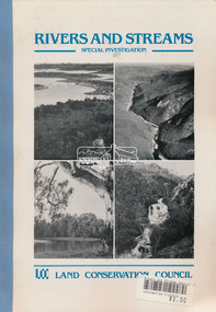
Book, Land Conservation Council, Rivers and Streams: Special Investigation, September 1989
... Rivers and Streams: Special Investigation ...In June 1987, the government directed the LCC to carry out a special investigation of the social, recreational, cultural and ecological values of rivers and streams in Victoria, and to make recommendations on the use of these rivers and how their identified values can best be protected. Notices announcing the commencement of the investigation were published in the Victoria Government Gazette and in Victorian newspapers in November 1987. A descriptive report was published in September 1989. The Council received 75 submissions following the publication of this report. After considering these submissions, the Council formulated its proposed recommendations, which were published in November 1990. The Council received 177 submissions commenting on the proposed recommendations. The Council published its final recommendations in June 1991. While welcomed by many, the study cut across the interests of other groups and was perceived to be particularly threatening to water authorities. The investigation resulted in a legislated system of 17 heritage rivers (with significant natural, recreational, scenic and heritage values) and natural catchment areas across Victoria. -
Tatura Irrigation & Wartime Camps Museum
Audio Tape, State Rivers and Water Supply Commission 75th Anniversary, 1981/05/01
... State Rivers and Water Supply Commission 75th Anniversary ...Tape made of the quarterly senior staff meeting to commemorate the 75th anniversary of the State RIvers and Water Supply Commission - 1st May 1981, speakers - W.E Bromfield, L.J Greenhill, F.C O'Connor, A.L. Tisdall, Sir Ronald East.S.R. & W.S.C 75th Anniversary 1st May 1981irrigation, victoria state rivers and water supply commission, bromfield, greenhill, o'connor, tisdall, sir ronald east -
Federation University Historical Collection
Book, Rivers of Gold: Rivers of Gold International Print Portfolio and Exchange 2017-2020: An Art-Science Collaborative Project, 2018
... Rivers of Gold: Rivers of Gold International Print ...gold covered art catalogue.printmaking, veronica calarco, paul croft, stuart evans, david ferry, wuon gean ho, mary lloyd jones, alison lochhead, jude macklin, ian phillips, gini wade, james pasakos, jimmy pasakos, diana orinda burns, robyn gibson, anne langdon, jan palethorpe, penny peckham, catherine pilgrim, melissa proposch, jacqueline aust, al bell, pauline bellamy, kathy boyle, mark graver, toni hartill, kim lowe, prue macdougall, jenny rock, lynn taylor, julie barratt, blair coffey, carolyn craig, christopher hagen, domenica hoare, tim misely, jude roberts, glenny briggs, jenny sanzaro-nishimura, jennifer stuerzl -
 Lakes Entrance Historical Society
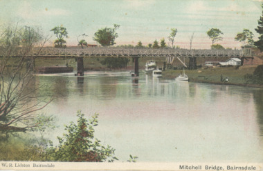
Postcard - Mitchell river, Port of Bairnsdale Victoria, 1900 c
... Rivers ...Wharf on the left side of the image was known as Top Wharf or Upper Wharf. Small house seen on eastern bank was home. Small house seen on eastern bank was home of Mr Healy Orchadist who sold fruit and grafted fruit trees. Big tree next to house was an enormous oak .Information from G ScarceTinted postcard showing first bridge over the Mitchell river, steamers and other boats at wharf on western bank known as Port of Bairnsdale Victoria. Also black and white photo of same view W.R. Lidston Bairnsdale Mitchell River Bairnsdaleboats and boating, rivers -
 Chelsea & District Historical Society Inc
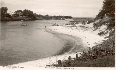
Photograph - Patterson River, Rose Series Postcard
The first bridge over the river was built in the early 1880's, prior to this it was a pontoon bridge.Black and white photo of Patterson River, looking east from the Patterson River Bridge. People in canoes on the river and sitting on the river bank. Houses can be seen on the opposite bank.THE ROSE SERIES P. 2908 - PATTERSON RIVER, CARRUM, VICpatterson river, chelsea, patterson river bridge, carrum bridge, canoes, beach, leisure, the rose series -
![Junction of the Rivers Yarra and Watt, Near Healesville / [by] Nicholas Caire, circa 1876](/media/collectors/550653872162f11fb04854aa/items/577740e5d0cdd10a5c0de011/item-media/57774153d0cdd10a5c0e0662/item-fit-380x285.jpg) Kew Historical Society Inc
Kew Historical Society IncPhotograph, Anglo-Australasian Photographic Company, Junction of the Rivers Yarra and Watt, Near Healesville, c. 1876
... Junction of the Rivers Yarra and Watt, Near Healesville ...Nicholas Caire was born on Guernsey in the Channel Islands in 1837. He arrived in Adelaide with his parents in about 1860. In 1867, following photographic journeys in Gippsland, he opened a studio in Adelaide. From 1870 to 1876 he lived and worked in Talbot in Central Victoria. In 1876 he purchased T. F. Chuck's studios in the Royal Arcade Melbourne. In 1885, following the introduction of dry plate photography, he began a series of landscape series, which were commercially successful. As a photographer, he travelled extensively through Victoria, photographing places few of his contemporaries had previously seen. He died in 1918. Reference: Jack Cato, 'Caire, Nicholas John (1837–1918)', Australian Dictionary of Biography.An original, rare photograph from the series 'Views of Victoria: General Series' by the photographer, Nicholas Caire (1837-1918). The series of 60 photographs that comprise the series was issued c. 1876 and reinforced a neo-Romantic view of the Australian landscape to which a growing nationalist movement would respond. Nicholas Caire was active as a photographer in Australia from 1858 until his death in 1918. His vision of the Australian bush and pioneer life had a counterpart in the works of Henry Lawson and other nationalist poets, authors and painters.Albumen Silver Photograph, mounted on Board.printed in ink on support l.c.: JUNCTION OF THE RIVERS YARRA AND WATT, NEAR HEALESVILLE. / COPYRIGHT REGISTERED. printed in ink on support reverse c.: VIEWS OF VICTORIA. / (GENERAL SERIES.) / No. 3. / JUNCTION OF THE RIVERS YARRA AND WATT, NEAR HEALESVILLE / The junction is situated about 3 miles from Healesville, and 35 miles from the mouth of the Yarra. The souces / of the Watt are to be found at the head of the Black Spur, and, being fed by a number of creeks and springs, its / waters gain considerable force for several miles before joining those of the Yarra. The "Old Bridge," at the junction, / is the name given to this crossing-place, which has been partly swept away by late floods. The depth of the Yarra here / is from 15 to 20 feet; that of the Watt, about 10 feet. printed in ink on support reverse l.c.l.: J.W. FORBES, Agent, printed in ink on support reverse l.c.: ANGLO-AUSTRALASIAN PHOTOGRAPHIC COMPANY, MELBOURNE. printed in ink on support reverse l.c.r.: 10 Temple Court, Collins Street West.nicholas caire (1837-1918), yarra river, watt river, bridge, wooden bridge, healesville -
 Lakes Entrance Historical Society
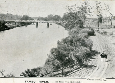
Postcard - Bridges, 1906
First timber road bridge over the Tambo River at Swan Reach officially opened 20 December 1905, after which punt was removed to BairnsdaleBlack and white postcard of the lifting bridge over the Tambo River at Swan Reach, Victoria. Man on horse standing on dirt road to Metung beside the river. Punt previously used to cross river visible against western bank of river.Tambo River (16 miles from Bairnsdale)bridges, waterways -
 Lakes Entrance Historical Society
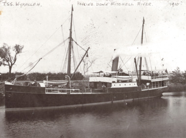
Photograph - TSS Wyrallah, TSS Wyrallah on Mitchell River, Bairnsdale Victoria, 1910
... Rivers ...Black and white photograph of the TSS Wyrallah with crew and passengers standing on after deck while steaming slowly down the Mitchell River near Bairnsdale VictoriaTSS Wyrallah Passing down Mitchell River 1910boats and boating, rivers, gippsland lakes -
 Sunbury Family History and Heritage Society Inc.
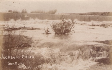
Photograph
... Rivers ...The river in flood is the Jacksons Creek. This section of the river with the waterfall is downstream from the town of Sunbury.A sepia photograph in post card format of a river with waterfalls in flood.rivers, jacksons creek, sunbury -
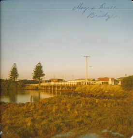 Port Fairy Historical Society Museum and Archives
Photograph
Moyne River Bridge 1970's North sideColoured photograph of Moyne river traffic bridge taken from the North side on the West bankMoyne River Bridge- on frontmoyne river, bridge, west side -
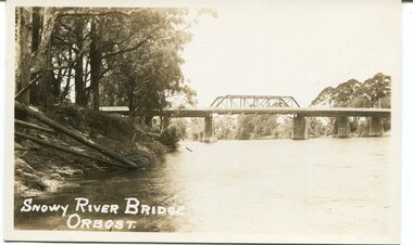 Orbost & District Historical Society
black and white photograph, first half 20th century
This is a photograph of the second Snowy River Bridge at Orbost. The section in the central span could have been built after flood damage. This bridge over the Snowy River was opened on July 4 1922. It was constructed in 1922 alongside the previous suspension bridge. Its building was a combined effort of the Victorian Railways and the Country Roads Board at a cost of 35,000 pounds. It was replaced in 1976 by the present bridge after several major floods.This bridge was replaced in 1976 after several major floods.A black / white photograph / postcard of a bridge over a river. It has what looks like a bo girder in the central section. On the left is the river bank.on front bottom left - "SNOWY RIVER BRIDGE"orbost snowy-river-bridge transport-bridge -
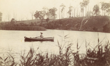
 Lakes Entrance Historical Society
Postcard - Nicholson River, Bulmer and Segenberg Bairnsdale, 1910
Also a second black and white postcard showing two rowboats on river at wide bend 05350.1 8.5 x 13.5 cmBlack and white postcard showing view of Upper Nicholson River with three women shown, water level low Nicholson VictoriaNicholson River waterways, boats and boating -
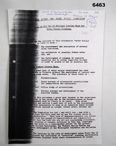 Bendigo Military Museum
Administrative record - Use of Military maps for water supply planning, 1962
... State Rivers and water supply Commision, Division of ...These are typed notes on the use of Military maps for water supply planning. This demonstrates the value of Military Mapping containing accurate relief information that can then be used for water supply planning.5 x A4 pages of typed notes, poorly photocopiedroyal australian survey corps, rasvy, fortuna, army survey regiment, army svy regt, asr, state rivers and water supply commission -
Phillip Island and District Historical Society Inc.
Book, CALTHROP, Dion Clayton, St. Quin, 1912
... Alston Rivers ...Labelled 'Cowes Free Public Library', 'Phillip Island Historical Society, Cleeland Bequest'. Stamped 'Readwell Library Service, Fern Tree Gully Library and Book Club at R.F. Marlan Est. Agt., Alpine St., Lower Fern Tree Gully, Tel. Gully 57'.english literature, fiction -
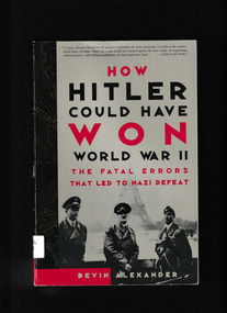 Monbulk RSL Sub Branch
Book, Three Rivers Press, How Hitler could have won World War II : the fatal errors that led to Nazi defeat, 2000
... Three Rivers Press ...Having already drawn both praise & controversy, this main selection for the Military Book Club continues to generate discussion among scholars & readers. Though histories of World War II are abundant, few of them examine the critical errors in Hitler's approach to the war that finally led to German defeat. Joining the ranks of "counterfactual" histories like the bestseller What If?, How Hitler Could Have Won World War II clearly shows what the consequences would have been for Hiltler, the Axis, & the world if he had chosen differently.Index, bibliography, notes, ill, maps, p.337.Having already drawn both praise & controversy, this main selection for the Military Book Club continues to generate discussion among scholars & readers. Though histories of World War II are abundant, few of them examine the critical errors in Hitler's approach to the war that finally led to German defeat. Joining the ranks of "counterfactual" histories like the bestseller What If?, How Hitler Could Have Won World War II clearly shows what the consequences would have been for Hiltler, the Axis, & the world if he had chosen differently.world war 1939-1945 - germany - military strategy, adolf hitler - military leadership -
Koorie Heritage Trust
Book, Bennett, M. M, The Australian Aboriginal as a human being, 1930
... Alston Rivers Ltd. ..." The problem of what to do with the race, the most interesting at present on earth, and the least deserving to be exterminated by us, and the most wronged at our hands, is not a difficult one to solve were a solution really desired." - Dr. Ramsay Smith, Commonwealth Year Book for 1909.146 p. ; index; 19 cm." The problem of what to do with the race, the most interesting at present on earth, and the least deserving to be exterminated by us, and the most wronged at our hands, is not a difficult one to solve were a solution really desired." - Dr. Ramsay Smith, Commonwealth Year Book for 1909.aboriginal australians. | aboriginal australians -- government relations. -
Linton Mechanics Institute and Free Library Collection
Book - Novel, Rivers, Dorothy, Tangled web, 1946
... Rivers, Dorothy ...A tale of romance and deception.188 p. : green cover, section of original dust jacket pasted to front, image of a woman cupping her face with her hands. Title and author's name hand printed on spine.fictionA tale of romance and deception.dorothy rivers, fiction, romance -
 Lakes Entrance Historical Society
Photograph - Mitchell River Bairnsdale Victoria, 1991 c
... Rivers ...taken from across the river looking back towards picnic area on right, site of old swimming pool below Court House. Colour photograph of Mitchell River Bairnsdale Victoria. Also three colour photographs of Mitchell River at Bairnsdale taken autumn 1991 settlement, rivers, topography -
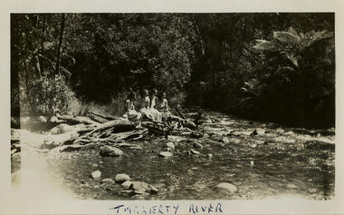 Marysville & District Historical Society
Photograph (item) - Black and white photograph, 1954
A black and white photograph of an unknown group of people at the Taggerty River in Marysville. The photograph was taken in 1954 whilst the group was staying at Roseleigh in Marysville.A black and white photograph of an unknown group of people at the Taggerty River in Marysville. The photograph was taken in 1954 whilst the group was staying at Roseleigh in Marysville.TAGGERTY RIVERmarysville, victoria, australia, roseleigh guest house, grieve family, thomas charles grieve, john arthur grieve, rose grieve, ackerman family, mary moyne, elise ackerman, ken mcleod, george peters, rose emily pullum, beltana, rose lillian smith, ivy may grieve, alexander james ficinus, raymond charles smith, accommodation, photograph, taggerty river -
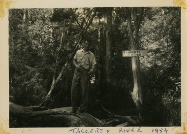 Marysville & District Historical Society
Photograph (item) - Black and white photograph, 1954
A black and white photograph of an unknown man at the Taggerty River in Taggerty. The photograph was taken in 1954 during a stay at Roseleigh in Marysville.A black and white photograph of an unknown man at the Taggerty River in Taggerty. The photograph was taken in 1954 during a stay at Roseleigh in Marysville.TAGGERTY RIVER 1954marysville, victoria, australia, roseleigh guest house, grieve family, thomas charles grieve, john arthur grieve, rose grieve, ackerman family, mary moyne, elise ackerman, ken mcleod, george peters, rose emily pullum, beltana, rose lillian smith, ivy may grieve, alexander james ficinus, raymond charles smith, accommodation, photograph, taggerty river -
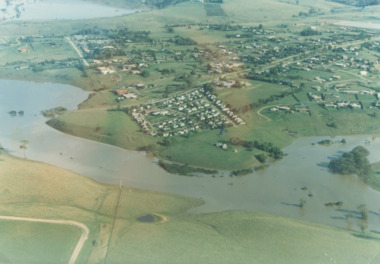 Lakes Entrance Historical Society
Photograph - Mitchell River in flood Bairnsdale Victoria, 1/04/1990 12:00:00 AM
... Rivers ...There was a deluge overnight in headwaters of Mitchell and Avon Rivers so the rivers rose overnight and flooded low lying areasColour aerial photograph of Mitchell River in flood showing Clifton Waters Village in centre and township of Wy Yung near Bairnsdale Victoriarivers, floods -
 Port Fairy Historical Society Museum and Archives
Postcard, The Rose Series / The Rose Stereographs, The Moyne River and bridge Port Fairy
Post card of the Moyne River BridgeBlack and white photograph of the Moyne river and Bridgehe Rose Series P. 10810 The Moyne River and Bridge, Port Fairybridge, moyne river, traffic, road -
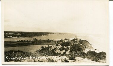 Orbost & District Historical Society
black and white photograph, C 1890s -1910
This is a photograph of the entrance of the Snowy River to Bass Strait. The entrance changes location but remains open for most of the year, although on occasions is closed by the prevailing weather and river water levels. In this photograph the entrance is quite wide and near the Marlo Hotel. This is a pictorial record of the Snowy River entrance at Marlo showing an open entrance.A black / white photograph / postcard of sandhills, river water on left and ocean on right. There is a group of buildings in the background - left. on front - "Snowy River Entrance Marlo"snowy-river-entrance marlo-snowy-river -
Marysville & District Historical Society
Photograph (item) - Black and white photograph, 1954
A black and white photograph of an unknown man at the Taggerty River near Marysville. The photograph was taken in 1954 during a stay at Roseleigh in Marysville.A black and white photograph of an unknown man at the Taggerty River near Marysville. The photograph was taken in 1954 during a stay at Roseleigh in Marysville.TAGGERTY RIVER 1954marysville, victoria, australia, roseleigh guest house, grieve family, thomas charles grieve, john arthur grieve, rose grieve, ackerman family, mary moyne, elise ackerman, ken mcleod, george peters, rose emily pullum, beltana, rose lillian smith, ivy may grieve, alexander james ficinus, raymond charles smith, accommodation, photograph, taggerty river -
 Lakes Entrance Historical Society
Postcard - Sylvia Gasson, Bulmer, 1914 to 1920 c
Also a second photograph of Mrs Gasson rowing a boat on the Nicholson river old road bridge in background showing central lifting span which never worked 05348.1Black and white postcard of woman Sylvia Gasson in a row boaty on Nicholson River Hill opposite shows signs of being cleared of trees Nicholsong VictoriaNicholson Rivertransport, agriculture, genealogy