Showing 519 items
matching small lake.
-
 Lakes Entrance Historical Society
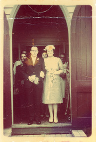
Photograph - Fraser/Edsall, 1963
... long sleeved frock and small floral head dress Lakes Entrance.... Bride in shin length long sleeved frock and small floral head ...Colour tinted photograph of Cyril and Joan nee Fraser Edsall standing in the doorway of St Nicholas Church of England after their marriage on 7 September 1963. Bride in shin length long sleeved frock and small floral head dress Lakes Entrance Victoria genealogy, fashion, celebration -
 Lakes Entrance Historical Society
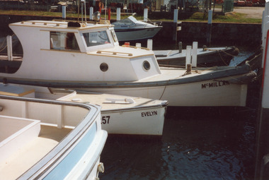
Photograph, 2001
... on Bullock Island. Small cabin cruiser called McMillan, open cockpit... Island. Small cabin cruiser called McMillan, open cockpit ...Date made November 2001Colour photograph of boats tied up at the Ports Jetty on Bullock Island. Small cabin cruiser called McMillan, open cockpit workboat called Evelyn, in foreground transom of larger cabin cruiser and in the background is a small aluminium run about. Lakes Entrance Victoriaships and shipping, dredging, jetties -
 Lakes Entrance Historical Society
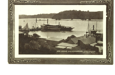
Photograph - New Works Jetty, Cooper, Alexander, 1909c
... on left and another small steamer. P S Tanjil tied to jetty... row boats and small sail boat. Lakes Entrance Victoria ...Also black and white copy with ornamental edge 17 x 26.5 cm, and another copy 19.5 x 30 cmBlack and white photograph showing excursion boats at New Works jetties, people on jetties. S S Gippsland tied to jetty on left and another small steamer. P S Tanjil tied to jetty on right. Roofs of works buildings and twin gable roof of J Carpenter's house on right. Several small row boats and small sail boat. Lakes Entrance VictoriaNew Works from Hummocks Cunninghamships and shipping, jetties, tourism -
 Ballarat Tramway Museum
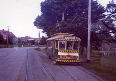
Photograph - Colour Photograph/s, Travis Jeffrey, 14/08/1971 12:00:00 AM
... a Twin Lakes advertising sign on the front of the tramcar. Small... on the front of the tramcar. Small portion of Lake Wendouree visible ...Colour photograph of Ballarat No. 12 entering the Martin Ave loop in Wendouree Parade, taken from the front of another tram. Photo a bit out of focus and has glass reflections from the other tramcar. No. 12 has destination of Mt. Pleasant and has a Twin Lakes advertising sign on the front of the tramcar. Small portion of Lake Wendouree visible in photo. Photo on Agfa Paper and taken on Friday 14 August 1971.Stamps with faded green ink: "Photo by Chris Jeffrey / Number" with number "104PC/11" in blue ink and date stamp "Friday 14 August 1971" also in faded green ink.wendouree parade, martin ave., tram 12 -
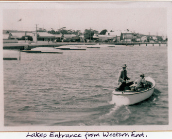 Lakes Entrance Historical Society
Photograph - Boat Harbour, 1925c
... of lake, timber groynes for sand control. On lake a small motor.... On lake a small motor boat containing two men. Lakes Entrance ...Black and white photograph of the western end of Esplanade, showing guest houses, businesses, Police Station, Methodist Church, cars parked in front of buildings, Bluestone wall at edge of lake, timber groynes for sand control. On lake a small motor boat containing two men. Lakes Entrance VictoriaLakes Entrance from western end.police, religion, waterfront, boats and boating, township -
 Lakes Entrance Historical Society
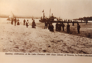
Photograph - Opening Entrance, Eastwood Bros, 1889c
... of wharf is PS Nell, other steamer SS Dargo?. Two small sailing... Dargo?. Two small sailing boats on lake. Lakes Entrance Victoria ...Two other copies in good order - b & w 14 x 20 cm, black and white 20 x 25.5 cm both have tear marksSepia photograph showing steamers at wharf near newly opened Entrance. People on steamers and wharf and on beach. Town on left background hummocks on right background. Steamer on end of wharf is PS Nell, other steamer SS Dargo?. Two small sailing boats on lake. Lakes Entrance VictoriaOpening celebrations at the Lakes Entrance 1889 (State Library of Victoria, LaTrobe Collection) waterfront, people, celebration -
 Lakes Entrance Historical Society
Postcard - Broome's Federal Hotel, 1920c
... aboard, on Lake two smaller craft moored at jetty, on left... with tourists aboard, on Lake two smaller craft moored at jetty, on left ...Also two other smaller postcards Also a larger copyBlack and White copy postcard of Broomes Federal Hotel showing a rambling weather board building. Launch with tourists aboard, on Lake two smaller craft moored at jetty, on left of scene one motor car parked at lake edge, bluestone seawall completed to west of jetty. Lakes Entrance VictoriaLakes Entrance Gippsland lakesguesthouses, boats and boating, waterfront, tourism -
 Lakes Entrance Historical Society
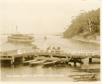
Postcard - Kalimna Jetty, 1920c
... , rustic jetty and small boat in background. Lakes Entrance... Gippsland Lakes Sepia toned small format postcard of the steamer ...also Black and white copy 10 x 12|also Sepia toned copy 10 x 15Sepia toned small format postcard of the steamer Gippsland leaving Kalimna Jetty, Gippsland Lakes Victoria, also showing boat ramps beside jetty, three rowing boats moored at lower landing, persons pushing trolly along jetty, Navigation light on jetty, rustic jetty and small boat in background. Lakes Entrance VictoriaKalimna Jetty Gippsland Lakesjetties, waterways, ships and shipping -
 Lakes Entrance Historical Society
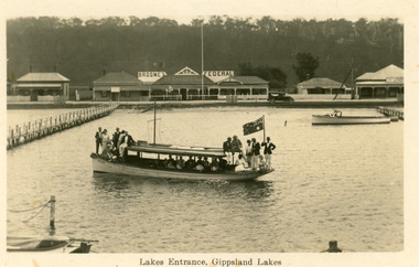
Postcard - SS Gippsland, Bulmer and Segerberg, c1912
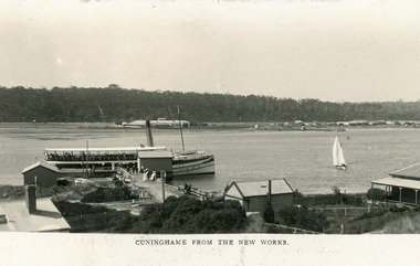
... Gippsland at New Works wharf, with passengers. Small sailing boat... Gippsland at New Works wharf, with passengers. Small sailing boat ...Black and white postcard showing view of township. Background shows Kalimna escarpment. Middle ground shows historic Club Hotel on left. Foreground shows New Works buildings, school building, corner of Harbour Master's house on right. SS Gippsland at New Works wharf, with passengers. Small sailing boat on lake. Lakes Entrance VictoriaCunninghame from the New Worksjetties, township, boats and boating -
 The Beechworth Burke Museum
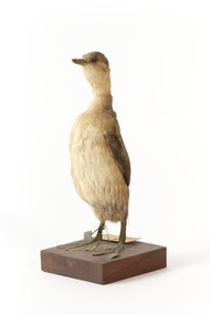
Animal specimen - Australasian Grebe, Trustees of the Australian Museum, 1860-1880
... lakes and ponds, small waterways or sheltered caves and bays... lakes and ponds, small waterways or sheltered caves and bays ...The Australasian Grebe is a small duck-like bird with a hyperactive nature. These birds reside in small, shallow, freshwater lakes and ponds, small waterways or sheltered caves and bays. They can be found throughout Australia and the Pacific region and New Zealand. The Australasian Grebe eat mainly small freshwater fish, crayfish, shellfish and leeches which they catch by diving underwater. This specimen is part of a collection of almost 200 animal specimens that were originally acquired as skins from various institutions across Australia, including the Australian Museum and the National Museum of Victoria, as well as individuals such amateur anthropologist Reynell Eveleigh Johns between 1860-1880. These skins were then mounted by members of the Burke Museum Committee and put-on display in the formal space of the Museum’s original exhibition hall where they continue to be on display. This display of taxidermy mounts initially served to instruct visitors to the Burke Museum of the natural world around them, today it serves as an insight into the collecting habits of the 19th century. This specimen is part of a significant and rare taxidermy mount collection in the Burke Museum. This collection is scientifically and culturally important for reminding us of how science continues to shape our understanding of the modern world. They demonstrate a capacity to hold evidence of how Australia’s fauna history existed in the past and are potentially important for future environmental research. This collection continues to be on display in the Museum and has become a key part to interpreting the collecting habits of the 19th century.This Australasian Grebe is in a standing position on a wooden platform with identification tags tied to the right leg. It has dark glass eyes and pale grey bill and legs. The plumage of this specimen consists of dark greys and browns on the rear with lighter colours on the underside. These colours align with those of the non-breeding season. This species has rufous red colouring on the chest and neck and darker colouring on the head during the breeding season. Paper tag: "34a Dabchick Catalogue, page, 64" Metal Tag: "4496"taxidermy mount, taxidermy, animalia, burke museum, beechworth, australian museum, skin, reynell eveleigh johns, bird, grebe, australasian grebe, dabchick -
 Eltham District Historical Society Inc
Photograph - Digital Photograph, Alan King, Alistair Knox Park, Eltham, 2008
... and a cascade flowing from a small lake to another below. A footbridge... and a cascade flowing from a small lake to another below. A footbridge ...Alistair Knox Park, an oasis of peace and beauty. Covered under National Trust of Australia (Victoria) Landscape Significance and Heritage Overlay, Nillumbik Planning Scheme. Published: Nillumbik Now and Then / Marguerite Marshall 2008; photographs Alan King with Marguerite Marshall.; p173 It is hard to imagine that the Alistair Knox Park, an oasis of peace and beauty beside busy Main Road, Eltham, was once the township’s rubbish dump. It was only in the 1970s that the tip was transformed into this beautiful six hectare space, which later earned it a National Trust Landscape classification. Before its life as a dump, the area was used for small farms. Thanks largely to the foresight and efforts of local environmental builder Alistair Knox, the park was designed sympathetically with the character of the wider Eltham landscape. Then, appropriately, the park was named after Knox, who was an Eltham Shire Councillor from 1971 to 1975 and Shire President in 1975. The park designers were four major forces in the urban bush landscape garden –Knox, landscape designer Gordon Ford, artist Peter Glass and landscaper Ivan Stranger. The National Trust citation for the park, originally called Eltham Town Park, includes the Eltham railway trestle bridge and the Shillinglaw Cottage. The citation states ‘the semi-natural setting of the parkland provides a landscape which is evocative of the history of the area’. Manna Gums (Eucalyptus viminalis) and Candlebarks (Eucalyptus rubida) are significant features. Most of the park’s construction was directed by Bob Grant, Superintendent of the Parks and Gardens Department for the Eltham Shire Council. First plantings occurred in Arbour Week in 1973, then the lake and botanic area were completed in 1975, with Federal Government funding, and the toilet block in 1978. Bounded by the Eltham railway line, Panther Place, Main Road, Bridge and Susan Streets, the park is in a valley about a kilometre wide overlooked by steep hills at the east and west. The Diamond Creek flows through it and the picturesque historic timber trestle railway bridge edges the north. Informal plantings of Australian indigenous and native species in open and undulating grassed settings blend with the natural landscape of the Diamond Creek to the west. The bush-style plants, particularly around the creek, balance with open lawns, paths and a cascade flowing from a small lake to another below. A footbridge over the creek leads to the park’s west. The park includes an adventure playground and barbecue areas. The park stands on part of the land bought from the Crown in 1851 by Josiah Holloway, who subdivided it into allotments and which he called Little Eltham. Most of the land was subdivided into residential lots, but the creek valley, on which the park stands, was subdivided into farm-size lots, used mainly for orchards and grazing. One of the earliest owners was John Hicks Petty, who in 1874 bought a plot from Holloway. Other families who owned properties in that area, included Rees, Clark, Waterfall, Graham, Hill and Morant. In 1901 the railway was built through the area. Jock Read, an Eltham resident since around 1920, remembers several farms in the 1920s and ’30s that occupied the site of today’s park. A poultry farm, which extended from present day Panther Place, was owned by the Gahan family. Next to that farm was another for grazing cattle owned by Jack Carrucan. Beside this was land owned by John Lyon. A doctor lived beside this, and at the north-west corner of Bridge Street and Main Road stood a memorial to the soldiers who died in World War One, which was later moved to the RSL site. Mr Read also remembers other farms and orchards west of the creek In the early 1960s the Eltham Council began buying these farms and in the late 1960s turned the areas east of the Diamond Creek into a garbage tip. When this was filled above the creek’s flood plain, the tip was moved to the west of the creek.This collection of almost 130 photos about places and people within the Shire of Nillumbik, an urban and rural municipality in Melbourne's north, contributes to an understanding of the history of the Shire. Published in 2008 immediately prior to the Black Saturday bushfires of February 7, 2009, it documents sites that were impacted, and in some cases destroyed by the fires. It includes photographs taken especially for the publication, creating a unique time capsule representing the Shire in the early 21st century. It remains the most recent comprehenesive publication devoted to the Shire's history connecting local residents to the past. nillumbik now and then (marshall-king) collection, alistair knox park, eltham -
 Kew Historical Society Inc
Postcard, R McGeehan, The Effect of Storm. Train Passing Through Flood Waters, South Yarra, 25-1-07, 1907
... to the dimensions of a small lake. Several shops were inundated, while... to the dimensions of a small lake. Several shops were inundated, while ...SHARP DOWNPOUR. ONE INCH IN 45 MINUTES. SOUTHERN SUBURBS DELUGED. TRAIN STOPPED AT SOUTH YARRA. One of the sudden downpours of rain which occasionally fall in Melbourne occurred yesterday afternoon, when nearly an inch of rain fell in the course of three quarters of an hour, and caused a flood for an hour or two in certain localities. During the early part of the day, the sky had been clouded over, but there was nothing to indicate a storm of such intensity as that which followed. At about half-past 1 o'clock residents of South Yarra, South Melbourne, Prahran, and St. Kilda noticed a few drops of rain. Still, it appeared unlikely that there would be anything exceptional, until with startling suddenness at about 10 minutes to 1 o'clock, one of the heaviest downpours within the memory of residents burst upon those suburbs. A strange feature of the storm was that it was practically confined to an area of about three miles square. The city was but little affected, though at a spot as close as the Observatory 86 points of rain were recorded in three-quarters of an hour. Thunder and lightning accompanied the downpour, which was cyclonic in character, the rain driving heavily from all points of the compass as the cyclone passed. It was in South Yarra and Prahran that the rain fell heaviest. Within a few minutes after it commenced, the low-lying portions of Toorak-road and practically the whole length of Chapel-street were under water. The depression at the intersection of Toorak-road and Darling-street speedily filled to the dimensions of a small lake. Several shops were inundated, while the water from the higher levels rushed down like a mountain torrent, and in several in-stances swept through the rear of houses and shops, carrying furniture in a floating mass against the further walls. In one case a footbridge was carried bodily away and dashed to pieces. Darling-street itself Great Davis-street, and other low-lying and flat thoroughfares in the vicinity became flooded from kerb to kerb, while on the other side of the railway-bridge the valley between Kensington-road and River-street became filled for some minutes to a depth of several feet. Meanwhile the waters from South Yarra hill, seeking a lower level, found it in the railway cutting, and the excavations from South Yarra station to Prahran on the one line, and to the Chapel-street bridge on the other, were converted into a couple of canals. At the platforms at South Yarra the water was two feet deep on the permanent way, and towards Hawksburn, at the sudden depression under Chapel-street bridge, it was at one time deep enough to cover a tall man's head. Into this swirling mass of water the 1:50 p.m. train from Oakleigh plunged on its way to Melbourne. The impact caused a mighty fountain of water to rise to a height of about 20 feet above the level of Chapel-street and send clouds of spray in all directions. Under the belief that a terrible explosion had occurred residents braved the rain and rushed to the spot, only to find that the train had been brought to a stand-still in the middle of what seemed to be a river. The water was so high that it had entered the fire-box from below, extinguishing the fires and cutting off the steam supply. In the meantime the officials at the South Yarra station had been preparing for emergencies. Inspectors were on duty at intervals along the line, and the moment the alarm was given an extra engine was backed carefully down and continued on to connect with the stranded train without losing its own power. There was a delay of about ten minutes in the service for an hour or two, but by 5 o'clock all the trains were running on time again, and the water had run off all but the spot beneath the Chapel-street bridge. Here the water remained about four feet deep until nightfall, and throughout the afternoon several hundreds of people including biograph operators and photographers, were gathered around watching each train pass through. Even with the water two feet lower, this was a work attended with considerable difficulty. Each train had to absolutely force its way through the weight of water, almost enveloped by the spray thrown up, and it was only just able to negotiate the "ford" by using every ounce of steam. ... The Argus, 26 January 1907, p19.The item forms part of the Laurie Bennett collection of thirty-six postcards and photographs of Kew and early Melbourne, donated to the Kew Historical Society in 1980. The postcards in the Bennett collection, like other images in the Society's holdings date from the 1890s to the present and comprehensively indicate points-of-view or scenes considered historically, aesthetically or socially significant in the period in which they were produced.Postcard depicting a flood at South Yarra Station in 1907. The title and photographer's name are identified on the front of the postcard. Donated by L. Bennett, 1980flood - south yarra, trains - melbourne, postcards, r mcgeehan - prahran -
 The Beechworth Burke Museum
Photograph, c.1927-1930
This image shows the Punt (a kind of small boat) that took residents of Bethanga across the Murray River before the Bethanga Bridge was built. Bethanga Bridge was built between 1927 and 1930, and was made a necessity by the building of the Hume Dam. The Hume Dam, formerly known as the Hume Weir, was in construction between 1919 and 1936, which swelled the Murray River into the floodplain to the East of the dam permanently, creating Lake Hume, and isolating the residents of Bethanga and nearby towns, for whom the trip all the way around the new lake to another river crossing was a massive undertaking. The person who wrote on the back of this card instead chose to cross the river on a boat until the Bethanga Bridge became available. Interestingly, partially submerged trees can be seen in the lake in the background of this photograph, illustrating that the dam had already begun to fill the floodplain even before the bridge was built. This photograph shows the methods the residents of Bethanga used while the Bethanga Bridge was being built. This record is associated with the Heritage Listed sites of the Hume Dam and the Bethanga Bridge, and shows the environment during the process of construction and the creation of Lake HumeSepia rectangular photograph printed on matte photographic paperReverse: 1997.3189 / 84 -19 -1 / This is the snap of the Punt. / Our only means of getting out / of Bethanga for the present / Until the bridge is completed / it is 2 miles above the junction / of the Mitta + Murray. It is / 1/2 a mile wide + runs across / the Murray into NSW / Kodak Print / bethanga, bethanga bridge, hume, hume dam, artificial lake, lake hume, hume weir, flood, floodplain, boat, punt, weir, pier, dock, transport, transportation -
 The Beechworth Burke Museum
Postcard
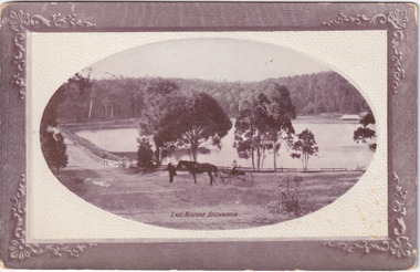
Black and white photograph depicts wide shot of Lake Kerford, where an older man stands with a horse and small carriage. On top of the carriage sits a small child, and both face towards the camera to pose. Photograph does not state when it was captured, but possibly been taken c. 1920.The postcard holds Historic significance due to its connection to Beechworth and its Lake Kerford. It demonstrates the interactions between nature and current European residents, especially how the lake has somewhat been 'protected' with the man made fencing and road. It also presents information on the environmental development or degradation for the area, with possible changes to the environment that may have been caused by human physical forces, natural decay or Global Warming. The social significance is due to the connection between the postcard and the individuals in the photograph.Black and white oval photograph on rectangular postcard, printed on card.Obverse: Lake Kerford / Beechworth Reverse: POST CARD / Stamp Here / Printed in Australia / This space may be used for Correspondence within the Commonwealth without extra postage / THIS SPACE IS FOR NAME AND ADDRESS / 84 - 108 - 1 / BMM3000lakes, lake kerford, beechworth, postcard, horse drawn carriage -
 The Beechworth Burke Museum
Postcard
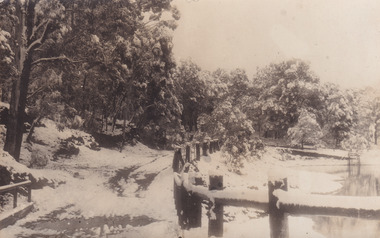
This postcard depicts Lake Kerferd during the winter season. With the photograph possibly been taken in the 1930s.The postcard holds Historic significance due to its connection to Beechworth and its Lake Kerford. It demonstrates the interactions between nature and colonialists, especially how the lake is surrounded by man made fencing and roads. It also shows that there was frequent human interaction with the area, due to the small snow slopes where vehicles would travel across. Black and white rectangular postcard, printed on card.Reverse: 56. / A03092 / 97.2205 POSTCARD / AUSTRALIA / KODAK CORRESPONDENCE / ADDRESS ONLY / KODAK / AUSTRALIA 84 - 134 - 1beechworth, lake, postcard, burke museum, black and white photograph, lake kerford -
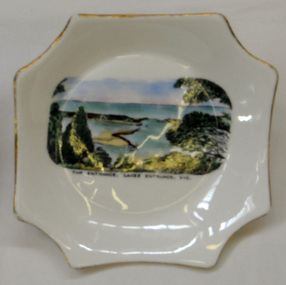 Orbost & District Historical Society
souvenir plate, 1930's-50's
This item is an example of a souvenir made for the East Gippsland region.A small white porcelain souvenir plate. A six sided shallow dish with a rectangular painting of the entrance at Lakes Entrance, East Gippsland. The dish is gold rimmed.Underneath - Royal Top- The Entrance Grafton Lakes Entrance, Vic Bone China Made in Englandsouvenir porcelain royal-grafton lakes-entrance -
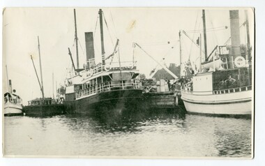 Orbost & District Historical Society
black and white photograph, before 1924
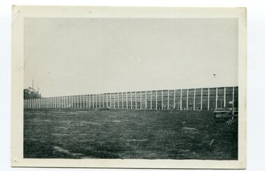
This photograph shows the Lady Harriett, her barge, the Wyrallah and Storm Bird with Captain Jimmy Bills at Harbeck's wharf, Lakes Entrance, The Lady Harriett was a small steamer that serviced the Tambo River and other areas. In 1895 the Lady Harriett was advertised to run between Bairnsdale and Mallacoota on a weekly service. The Lady Harriett and barge did two or three trips up the Tambo per week. She did not carry passengers or run to a timetable and would carry maize and beans as well as fish from Mallacoota where by 1900 the fishing industry was well established' Lady Harriett towed her barge carrying an assortment of goods up the Tambo from 1895 to 1913. The S.S. Wyrallah was a regular Melbourne header for over twenty years. She was run down and sunk by the steamer Dilkera with the loss of six lives at Port Philip Head. (ref. The Argus Friday April 11 1924)This is a pictorial record of a once busy wharf. From Lakes Entrance ocean-going vessels had access to the Gippsland Lakes, the largest navigable inland waterway in Australia.A large black / white photograph of two large ships and two smaller ones at a wharf. There are people on the wharf and on the boats.on back - "Jo-Bull", L-R Lady Harriet.........."lady-harriett s.s.-wyrallah shipping-east-gippsland harbeck's-wharf-lakes-entrance sea-transport -
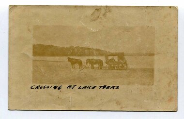 Orbost & District Historical Society
black and white photograph, late 19th - early 20th century
In the late 19th century in the Orbost area roads were just bush tracks which generally were unsuitable for any type of vehicular traffic so were traversed mainly by horseback. As the settlement grew, a weekly mail service from Cunninghame (Lakes Entrance) was estab-lished. The settlers had to carry the mail for three months and each took a turn as mailman during that time. The first coach was driven by Mr Alex Hall. Eventually a daily mail service was set up and many drivers included B. Sutherland, W. Middleton, Jonson Bros., J. Mitchell, F. Newport, J. Geddes, A. Coulson, Bert Cessor, H. Weekes and A. Barthile. (info. from Newletter August 2007) This photograph is one of A. Coulson’s Coach crossing the Sand Bar at Lake Tyers.This is a pictorial record of very early transport in East Gippsland.A very faded small postcard / photograph of a horse and cart crossing a beach.on front in black writing - " Crossing at Lake Tyers" on back - "A Coulson"lake-tyers transport coulson-coaches -
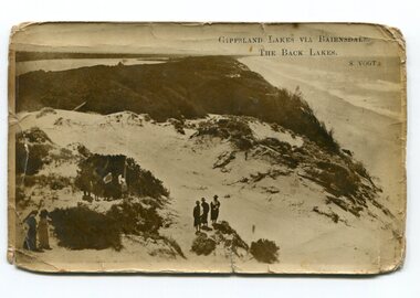 Orbost & District Historical Society
black and white photograph, Vogt, Stanley, first half 20th century
Back Lake track is near Metung, East Gippsland.This is a pictorial record of the Gippsland Lakes in the early 20th century.A black / white postcard photograph of a beach scene. Small groups of people are standing on a vegetated sand dune overlooking the water. on front - " Gippsland Lakes via Bairnsdale - the Back Lakes, S. Vogt"gippsland-lakes back-lake-bairnsdale -
 Orbost & District Historical Society
black and white photograph, Vogt, Stanley, 1918
Maize,has been grown on the Orbost flats for at least 70 years. When early settlers began to arrive on the Snowy River somewhere in the 1880s, the land was mostly swamps and heavily timbered jungle on the river frontages. The swamps were drained, bit by bit, by men with short handled shovels and working in mud and water. The frontages were cleared by axe and shovel and fire. Several kinds of crops were experimented with such as hops, hemp and maize, the latter grew particularly well and became the main crop of district. The problem then was to thresh and deliver the product to the market. A small single cob machine was brought here and one man turned the handle, while the boy or Mum fed the cobs singly into the machine. A good day’s work would thresh about 50 bushels or about 12 bags (4 bushels). The task then was to cart the maize to market. For a few years this was done by horses and dray carrying about 60 bushels to Mossiface, where it was loaded onto river boats to Lakes Entrance, and then by ocean boats to Melbourne. Later it was taken to Bairnsdale by foot and loaded onto the trains to Melbourne. (more information in Newsletter October 2006) This crib, measuring seven chains, sixteen feet, contained 10,000 bags of maize cobs which were grown by Linc Timmons on Peter Irvine's farm (Fairlea?) in Orbost, East Gippsland. The growing of maize in the Orbost district contributed significantly to the economy of the township for many years, The many maize cribs once seen on the surrounding farms have now disappeared and this photograph is a pictorial record of that significance.A black / white photograph of a large maize crib full of maize in a paddock. There is a large framed copy of the original.agriculture-orbost farming-maize-orbost maize-crib-orbost -
 Orbost & District Historical Society
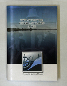
book, Exploring the Gippsland Lakes 1882, January 2010
The original book was published in Melbourne by M.L. Hutchinson, 1881. This edition was specially compiled for the Lakes Navigation Company by J. Blackwood Howie.A small book - Exploring the Gippsland Lakes 1882. this is a republication of a C 1882 book titled Tourists and Sportsman's Guide to the Gippsland Lakes and Surrounding Country. This pocket reading republishes a story from 1882 that was aimed at promoting tourism to the Gippsland Lakes. It starts with a train trip from Melbourne to Sale and then boards a steamer to experience the Gippsland Lakes. The book was published by Paynesville Maritime Museum in January 2010. It was compiled by J. Howie Blackwood.gippsland-lakes travel tourism-east-gippsland -
 Orbost & District Historical Society
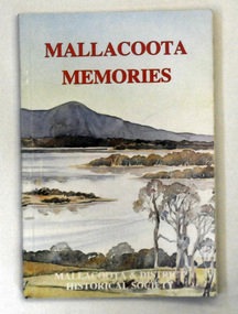
book, Mallacoota Memories, 1980
This book was produced by the Mallacoota and District Historical Society. The Society, founded in 1974, has a museum housed in a World War 2 Bunker in Mallacoota . The bunker was handed over to the Society by the R.S.L.A small 104 pp book titled Mallacoota Memories. On the front cover is a coloured photo of lakes and trees. The title is in red. The book contains early observations by J.[G] A. Robinson; contact with settlers; mentions Biduelli, Kruatungulung, Murring, Ben- Kurnai, Mallekotang Mittong, Tinnon, Kyrekong, Ponedyang, Worarer Mittong groups. The history is from 1841 -1945. It was produced by Mallacoota and District Historical Society.mallacoota-history robinson-j.a -
 Orbost & District Historical Society
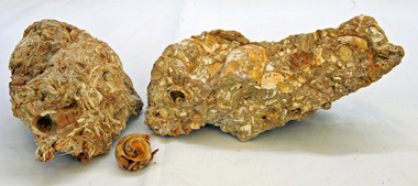
fossils
These were collected from the Lake Tyers area at Red Bluff. Inspected by George Rawlings 6.2.2013.Two lumps of fossil rock with a small shell broken off one. The shells are filled with calcite.fossil shells calcite lake-tyers -
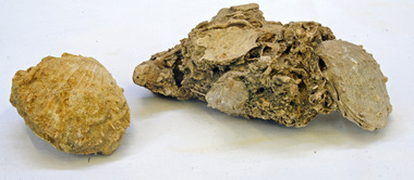 Orbost & District Historical Society
fossils
These were found at Red Bluff at Lake Tyers. Inspected by George Rawlings 6.2.2013.Two lumps of shell fossils. The smaller, .1, is a shell and the larger .2 is a cast of spondylus, a genus of bivalve molluscs, gasteropodes. This is in calcite.fossils shells red-bluff bivalve molluscs spondylus -
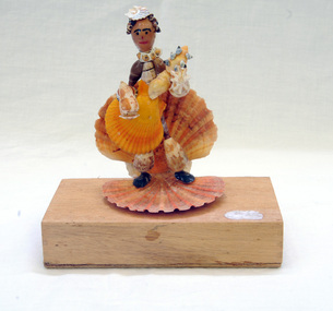 Orbost & District Historical Society
shell ornament, c. early to mid 20th Century
Mrs Elma Camm (nee Freeman) was the wife of Herbert Desmond Camm. Des and Elma lived in Orbost from 1971-1980/1. Des died on 9/11/1980 and is buried in Orbost Cemetery. Elma moved away and is presently (2013) in care at Lakes Entrance. Elma's hobby was collecting shells and crafting them into interesting forms. Much of her work is in the Shell Museum in Lakes Entrance. The figurine in Orbost Museum was donated by Elma.This item is an example of the handcraft skills of women in the early to mid 20th century.A small figurine made completely of different shaped shells and set onto a wooden block as its base. The block was originally a Wee William cigar box. The figure is playing a stringed instrument, possibly a guitar, held in front of him/her. The hat is a small shell.shell-art figurine recycled-materials -
 Ringwood and District Historical Society
Photograph, Kubis Estate, North Ringwood in April 1978. Looking upstream from below the retaining wall of Loughnan's Lake that was where the truck tracks disappear. The wall was extended to the left across what was then a small gorge
E548 N19 Part of a 51-photo record of the development of the "Kubis" Estate, Ringwood North, including road works to Debbie Place, Kubis Drive, Werac Drive, Manuelo Drive, Iluka Place and Glenvale Road. From the Jack Lundy Clarke collection. -
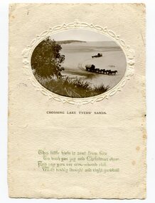 Orbost & District Historical Society
black and white photograph, late 19th century - early 20th century
This photograph has been set as Christmas postcard. It could be the front page of a greeting card.Postcards and greeting form a vital part of social and historical records for researchers. They are very interesting records of places gone, architecture gone and people gone, showing social history such as dress, or early automobiles. This one record an earlier means of transport in east Gippsland.A small black / white oval shaped photograph set in a cream card with green writing at the bottom. The photo is of two horse teams and buggies crossing a large sandy beach.on front just below photograph - CROSSING LAKE TYERS SANDS Beneath that in cursive script is " This little view is sent from here To wish you joy and Christmas cheer And say you are remembered still with kindly thoughts and right goodwill"lake-tyers-east-gippsland greeting-card -
 Orbost & District Historical Society
black and white photograph
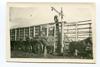
Maize,has been grown on the Orbost flats for at least 70 years. When early settlers began to arrive on the Snowy River somewhere in the 1880s, the land was mostly swamps and heavily timbered jungle on the river frontages. The swamps were drained, bit by bit, by men with short handled shovels and working in mud and water. The frontages were cleared by axe and shovel and fire. Several kinds of crops were experimented with such as hops, hemp and maize, the latter grew particularly well and became the main crop of district. The problem then was to thresh and deliver the product to the market. A small single cob machine was brought here and one man turned the handle, while the boy or Mum fed the cobs singly into the machine. A good day’s work would thresh about 50 bushels or about 12 bags (4 bushels). The task then was to cart the maize to market. For a few years this was done by horses and dray carrying about 60 bushels to Mossiface, where it was loaded onto river boats to Lakes Entrance, and then by ocean boats to Melbourne. Later it was taken to Bairnsdale by foot and loaded onto the trains to Melbourne. (more information in Newsletter October 2006)The growing of maize in the Orbost district contributed significantly to the economy of the township for many years, The many maize cribs once seen on the surrounding farms have now disappeared and this photograph is a pictorial record of that significance.A black / white photograph of a man unloading maize from a horse-drawn wagon into a maize crib. Another man is standing by the horse.maize-crib-orbost agriculture maize-corn-orbost -
 Orbost & District Historical Society
black and white photograph, late 19th century - early 20th century
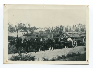
Maize, or corn as it is called in America and New South Wales, has been grown on the Orbost flats for at least 70 years. When early settlers began to arrive on the Snowy River somewhere in the 1880s, the land was mostly swamps and heavily timbered jungle on the river frontages. The swamps were drained, bit by bit, by stout hearted men with short handled shovels and working in mud and water. The frontages were cleared by axe and shovel and fire. Several kinds of crops were experimented with such as hops, hemp and maize, the latter grew particularly well and became the main crop of district. The problem then was to thresh and deliver the product to the market. A small single cob machine was brought here and one man turned the handle, while the boy or Mum fed the cobs singly into the machine. A good day’s work would thresh about 50 bushels or about 12 bags (4 bushels). The task then was to cart the maize to market. For a few years this was done by horses and dray carrying about 60 bushels to Mossiface, where it was loaded onto river boats to Lakes Entrance, and then by ocean boats to Melbourne. ( from NEWSLETTER OCTOBER, 2006) This is a pictorial record of farming practices in Orbost in the early 20th century.A black / white photograph of a horse team hauling a wagon loaded with bags of maize.A man is sitting on the edge of the wagon.farming-orbost agriculture maize corn transport -
 Warrnambool and District Historical Society Inc.
China, Cups x 4, 1864
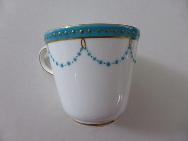
... minton cups mrs annie lake Minton Four small white cups decorated ...These dishes were part of a crockery set used in the George Rolfe household at Lyndoch, Warrnambool. George Rolfe (1836-1919) was a Melbourne tea merchant who acquired land at the mouth of the Hopkins River in Warrnambool from the 1880s on as a holiday home. He developed the property over the years, adding a windmill and reservoir, bone and chaff sheds, a stable, jetty and boathouse and an extensive garden. In 1891 he married Mrs Annie Lake and it was his stepdaughter, Florence Lake who built the house, Lyndoch in the 1920s. This building today forms part of an Aged Care Facility. This item is part of the larger Rolfe dinner set as described on Victorian Collections at VC001421 and VC001422These cups are part of a crockery set, and are kept because they belonged to George Rolfe, a prominent property owner and farmer in Warrnambool in the late 19th century and early 20th century. The items, dating from 1864, have social significance showing the type of crockery used by a more affluent family in the 19th century.Four small white cups decorated with aqua band around the top of each cup . A scalloped pattern of dots are suspended from the solid band which is decorated with a row of gold dots. There is a gold rim at the base of the cup.Mintonrolfe, lyndoch, warrnambool, minton cups, mrs annie lake