Showing 107 items matching "stonier-kipen"
-
 Phillip Island and District Historical Society Inc.
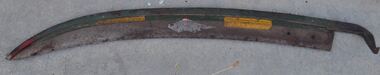
Lamp, 19th Century
Riding lamp from the 'Genista' which was the regular car ferry from Cowes to Stony Point from 1889 to 1930 Riding lamp with glass chimney on a trapezoid brass lamp base.Venus engraved on basecowes, lamp, riding lamp, genista, stony point, car ferry -
 Phillip Island and District Historical Society Inc.
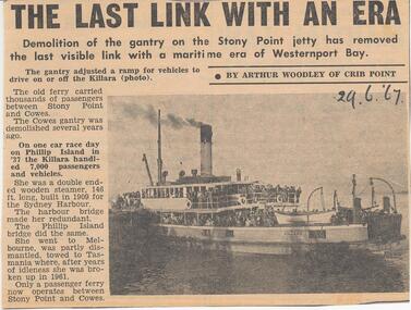
Newspaper Clipping, The Killara, 29/6/1967
Collection of Newspaper Clippings from Scrap Book 1960 - 1973Article about the demolition of the gantry on the Stony Point jetty in June 1967. Cowes gantry was demolished several years earlier. The Killara on one race day on Phillip Island handled 7,000 passengers and vehicles.stony point, the killara ferry, cowes jetty, cowes jetty - ferry ss "killara", phillip island, newspaper clipping, jean jamieson -
 Federation University Art Collection
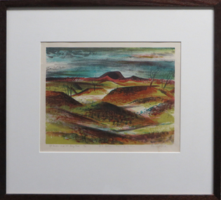
Work on paper - Artwork - Printmaking, Jack, Kenneth, "Mt Porndon and the Stony Rises - No 6 Volcanic Plains of Victoria" by Kenneth Jack, 1962
Kenneth JACK AM MBE RWS, (5 October 1924 – 10 June 2006) Australian watercolour artist Kenneth Jack who specialised in painting the images of an almost forgotten outback life; old mine workings, abandoned ghost towns, decaying farm buildings. He became a professional painter at the age of 39 after giving up his job as senior instructor at the Caulfield Institute of Technology. In 1977 he was elected to The Royal Watercolour Society and in 1982 was awarded the MBE, and the Order of Australia (AM) followed in 1987. Framed three block lino print showing the volcanic plains of Victoria around Stony Rises. It is Number 6 in the Volcanic Plains of Victoria series. Donated through the Australian Gifts Programme by Katherine Littlewood.31/40artwork, artist, kenneth jack, printmaking, volcano, mt porndon, mount porndon, linocuts -
 National Wool Museum
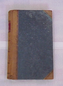
Book
Ledger from the Mount Fyans station, property of William Cumming, Mount Fyans, and Thomas F Cumming, Stony Point, Victoria.LEDGERshearing sheep stations - management, cumming, mr w. b., mount fyans stud, victoria, shearing, sheep stations - management -
 Phillip Island and District Historical Society Inc.
Photograph
Vehicular Ferry SS "Killara". Also took stock and passengers between Stony Point, French Island and Cowes from 1933 - 1942.Close up of vehicle on ramps being unloaded.local history, photography, photographs, slides, film, steam ships, transport, black & white photograph, transport, steam ships -
 Phillip Island and District Historical Society Inc.
Steam whistle
Steam whistle which sits near the ships funnel from the 'Killara' which was a car ferry from Cowes to Stony Point from 1933.Brass and steel ships whistlephillip island, cowes, stony point, killara, steam whistle, car ferry -
 Phillip Island and District Historical Society Inc.
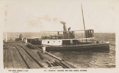
Photograph, Genista leaving Cowes Pier
From Jessie Smith's collection. The S.S. Genista was an early steamer running between Stony Point, Cowes, Rhyll and San Remo c.1880's.Sepia Photograph - close-p of S.S.Genista with stern in line with pier. Man leaning over edge of pier at middle left.The Rose series P655 - S.S. Genista leaving the pier, Cowes Victoria. Copyright.local history, photographs, shipping, maritime technology, ferries, cowes, phillip island, sepia photograph, water transport cowes, jessie smith collection, stan mcfee -
 Stawell Historical Society Inc
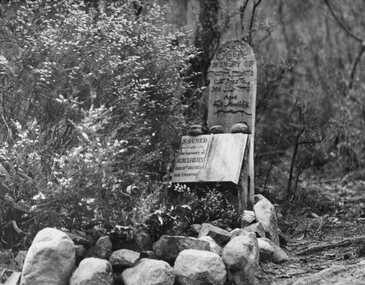
Photograph, Miss Agnes Folkes' Grave -- close to camping ground near Stony Creek in Halls Gap
Halls Gap. A Lonely Childs Grave (Agnes Folkes) close to camping Ground beside walk Stony Creek. The child's parents had a Sawmill nearby.halls gap -
Bialik College
Document (Collection) - Israel Kipen collection, Box 2
1960s1960s -
Whitehorse Historical Society Inc.
Article, History a total mystery, 11/02/1997 12:00:00 AM
... Stonier-Kipen ...Little is known about aborigines who lived in the area now known as Boroondara.Little is known about aborigines who lived in the area now known as Boroondara.Little is known about aborigines who lived in the area now known as Boroondara.aborigines, mcwilliam, gwen, stonier-kipen, claire, city of boroondara -
Bialik College
Document (sub-series) - Israel Kipen collection, Box 3
1950s, 1960s, governance1950s, 1960s, governance -
 Phillip Island and District Historical Society Inc.
Newspaper clippings
Letter to newspaper referring to Car Ferry charges at Phillip Island, quoting charges Stony Point to Cowes 15/- car 7/6 trailer 7/- driver and each passengerLetter to newspaper on Phillip Island Ferry Fares.local history, documents, newspapers, phillip island, ferries, black & white newspaper clipping -
 8th/13th Victorian Mounted Rifles Regimental Collection
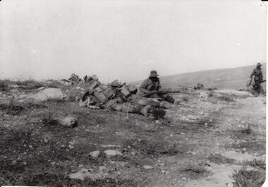
Photograph - 8th LH outpost, 1918 circa
The 8th Light Horse Regiment was engaged in the battle to capture Turkish defences at Tel El Khuweifle 16 Kilometres north of Beersheba from 1 to 6 November 1917. Other units were drawn from Imperial Camel Corps, British Yeomanry Division, New Zealand Mounted Rifles and 53 Welsh Division. The 8th Light Horse Regiment AIF was raised at Broadmeadows Victoria in September 1914 under the command of Lieutenant Colonel Alexander White and formed part of the 3rd Light Horse Brigade. The regiment served at Gallipoli where in a courageous but ill-fated charge at the Nek on 7 August 1915 it suffered horrendous casualties including Lieutenant Colonel White. Rebuilt in Egypt under the command of Lieutenant Colonel Leslie Maygar VC the regiment went on the serve throughout the Middle East Campaign. Colonel Maygar died of wounds at Beersheba when the regiment was attacked by enemy aircraft while waiting to follow up the successful charge of the 4th LH Brigade on 30 October 1917. The 8th Light Horse AIF was disbanded in 1919, but soon after re-raised as the 8th (Indi) Light Horse in the Citizen Military Forces, superseding 16th (Indi) Light Horse.Part of a rare collection of photographs of 8th Light Horse Regiment AIF during WWI (1914-1918).Black and white photograph of two soldiers of the 8th Light Horse Regiment AIF wearing slouch hats and armed with rifles. They are near three figures wearing helmets lying on the ground, possibly men of the Imperial Camel Corps or British infantry. Below photograph "Stony desert landscape known as Khuweilfe ( Thirsty Ridge ), 8 miles north of Beersheba. Only had a little water hence the name",tel el khuweifle, 8th, light horse, world war one, wwi -
Bialik College
Mixed media (item) - Oversized items from Kipen files, 1970s, c. 1970s
Oversized items from Kipen files, c. 1970s. Includes a photograph of students, correspondence regarding the opening of the Wantirna campus, newspaper articles and plans of the Auburn Road campus. Please contact [email protected] to request access to this record. -
 Bendigo Historical Society Inc.
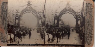
Photograph - HARRIS COLLECTION: STEREOSCOPIC VIEWS, 1908
Rose Stereoscopic Views. 1. Duke of York Celebrations Melbourne. 2. Duke of York Celebrations Melbourne. 3. Delhi Durbar State Entry into Delhi. Camels in the Procession. 4. The Splitters Falls, Gulf Stream, near Stony Creek, Grampians, Vic Australia,Rose Stereoscopic Viewsphotography, viewers -
 Halls Gap & Grampians Historical Society
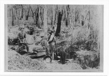
Photograph - B/W, C 1887
D'Alton's searching for alluvial gold. Photo shows Alfred and Charles D'Alton at Stony Creek Diggings. Charles is on the right and Alfred is on the left. Records 126 and 127 are enlargements from this photo showing each man separately.Photo shows two men working near a sluice. One man is shovelling into a sluice, on a creek and the other is holding an implement. A gold pan rests against a tree.people, d'alton, mining, stoney creek -
 Phillip Island and District Historical Society Inc.
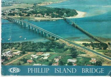
Booklet, Official Opening of the Phillip Island Bridge at San Remo 1969 and notes by the Bridge engineer, Tom Russell, 1969
Prior to 1939 access to the Island was by punt from San Remo or car ferry from Stony Point. A bridge was opened in 1940 but increased traffic and low load capacity was a problem. The decision to build a new bridge was made in the 1960s.HistoricalColoured, bound booklet with a photo of the old and new Phillip Island bridges on the cover and the CRB logo and name on rear. It includes the order of proceedings for the opening and bridge statistics, plans and contractor information. Also photos of construction and a history of travel to the Island before a bridge was built and the first bridge. There is also a 2 page typed document written by the bridge engineer who gives a brief history of access to the Island and problems at the opening with access and a rebel who tried to open it unofficially.Official Opening of the Phillip Island Bridge at San Remo by The Hon. M.V. Porter, MLA. Minister of Public Works. November 21 1969bridges, 2nd phillip island bridge construction, tom russell, phillip island bridge opening 1969 -
Bialik College
Document (series) - Israel Kipen collection, Box 1
-
 Phillip Island and District Historical Society Inc.
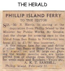
Newspaper clippings
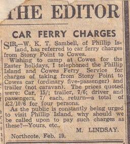
Letter to newspaper indication Ferry Fares on Sand Remo and Stony Point runs. 7/- small car, 10/- large car, cars transported free in winter. Correcting statement made in a previous newspaper report that cost for a car was £1.30/-Letter to newspaper indicating Ferry fares at Phillip Island.local history, documents, newspapers, phillip island, ferries, san remo, stony point, black & white newspaper clipping, ferry fares, san remo to stony point -
 Phillip Island and District Historical Society Inc.
Newspaper clippings
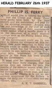
Letter to paper indicating high cost of providing Ferry Services at Phillip Island and pointing out that fares could be reduced if the Government paid for maintenance of Cowes and Stony Point Ferry Docks. All other facilities in the State have been provided by the Government.Letter to newspaper re costs of running Phillip Island Ferry services.local history, documents, newspapers, phillip island, ferries, black & white newspaper clipping, ferry fares, a k t sambell -
 Phillip Island and District Historical Society Inc.
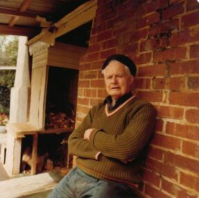
Photograph, 1978/9
Charlie Richardson was the son of William Richardson and grandson of Joseph Richardson who arrived on Phillip Island in 1868. Mr Charlie Richardson was for many years the Mate of the Rhyll-Stony point Ferry. He grew up at Rhyll and attended the Rhyll State School with his brothers and sisters.Coloured photograph showing Charlie Richardson on verandah of his home at Rhyll, Phillip Island.local history, photographs, buildings - historical, housing, coloured photograph, john cook, phillip island, charlie richardson -
 Stawell Historical Society Inc
Photograph, Set of coloured print postcards of Stawell and Area
-1 Waterfall Grampians Stawell with writing on back. -2 Stony Creek Grampians Stawell - writing on back -3 Venus Bath Grampians Stawell -4 Town Hall Stawell -5 Central Park Stawell -6 Main Street Stawell -7 Glenorchy Bridge Stawell 7 coloured by hand postcardstourism -
 Whitehorse Historical Society Inc.
Machine - Cultivator
p34 'Old Farm Machinery in Australia' Society Ref.Horse drawn, hand operated Spring Tyne Orchard Cultivator. It can be paired with a similar cultivator. Has 7 tynes one disc at rear both adjustable. Depth of tyne into soil controlled by levers for light scratching to deep. The weight per tooth was 1/2 that of ordinary English harrow. Useful for rough stony ground.'Harvey' - on rear disc adjuster pivot.rural industry, orcharding -
Bialik College
Document (sub-series) - Oral Histories, 2012, 2012
-
Federation University Historical Collection
Plan, R. Underwood, Shire of Winchelsea, 1952, 10/10/1952
Copy of a plan of the Shire of Winchelsea including Lake Wollard, Wormbete, angahook, boonah, Barwon Downs, Kaanglang, St Gerge River, Cumberland Creek, Stony Creek, Bambra, Wensleydale, yan Yan Gurt, Tutegong, Mirnee, Karngun, whoorel, Birregurra, Barwon River, Thompson's Creek, Bass Straight. Mt Defiance, Mt St George, Loutit Bay, Airey's Inlet, Salt Creek, Mathew's Creek.winchelsea, lake wollard, wormbete, angahook, boonah, barwon downs, kaanglang, st george river, cumberland creek, stony creek, bambra, wensleydale, yan yan gurt, tutegong, mirnee, karngun, whoorel, birregurra, barwon river, thompson's creek, bass straight. mt defiance, mt st george, loutit bay, airey's inlet, salt creek, mathew's creek, r. underwood, why river, point sturt, barwon downs, forest -
 Bendigo Historical Society Inc.
Tool - TYZACK SCYTHE BLADE
Scythe Blade. Remains of two yellow paper labels. One label contains 'Trade Mark W.A. TYZACK & CO LTD. SHEFFIELD' The other contains 'PATENT UNBREAKABLE POINTED SCYTHE' This scythe has an advantage over any other scythe, as The Point cannot be broken in stony or rough ground' An embossed stamp on The scythe has the words 'W. A. TYZACK & Co. Ltd. Stella Works, Sheffield. -
 Phillip Island and District Historical Society Inc.
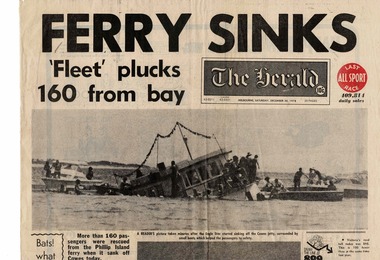
Newspaper, Eagle star ferry sinks, 30 December 1978
The Eagle Star left from Stony Point to take in Tankerton on the way to Cowes. It carried about 160 passengers of all ages, many of whom were probably planning to celebrate New Year’s Eve or start their holidays on the Island. The 48-year-old ferry had only recently been bought by a co-operative of French Island residents. Fortunately no one was drowned, and only two people were hurt.HistoricalBroadsheet front page from The Herald Saturday, December 30 1978.Headline is "Ferry sinks."Fleet" plucks 160 from bay" Large black and white photo showing half submerged ferry and three smaller motor boats pulling people from the water. other people are standing on the front of the ferry.Headline is "Ferry sinks."Fleet" plucks 160 from bay" ferries, eagle star, transport, cowes yacht club -
 Ballarat Heritage Services
Photograph - Colour, Clare Gervasoni, Fawcett Hall and Public Library, 2015, 11/01//2015
Fawcett Hall is 14 kilometres North West of Alexandra, North East Victoria, in Spring Creek Road and is set amongst a small picturesque rural farming and business community with hills as a backdrop and Stony Creek running alongside the public reserves property boundary. Part of our hall building dates back to its establishment in 1882. Originally the hall served as a Mechanics Institute and Public Library and later as a primary school.Colour photograph of a weatherboard Hall.fawcett hall and public library, fawcett, fawcett mechanics' institute -
 Phillip Island and District Historical Society Inc.
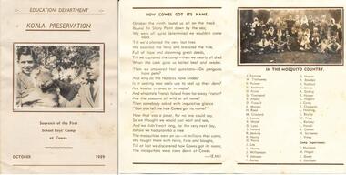
Souvenir Photographs, Education Department Koala Preservation, 1939
The boys came across from Stony Point and planted trees and were plagued by mosquitoes. The poem is quite humorous describing their venture to Cowes. They decided that Cowes derived its name - "The mosquitoes were cows down at Cowes." On the back of the folder is a note from E Murnane, one of the Supervisors, to "Dear John". The poem is most likely written by E Murnane too as it has the initials (E.M.) at the end. The Souvenir Folder was donated by Neil Lacco.A souvenir folder with two photographs included of the First School Boys' Camp at Cowes run by the Education Department. The souvenir also includes a poem called "How Cowes Got Its Name" and a list of the participants. Photograph on the front shows three boys with a koala. Photograph inside the folder shows all the boys and Camp Supervisors.As shown on the front: Education Department Koala Preservation Souvenir of theFirst School Boys' Camp at Cowes. October 1939.koala preservation, first school boys' camp cowes, e murnane, neil lacco, education department -
 Warrnambool and District Historical Society Inc.
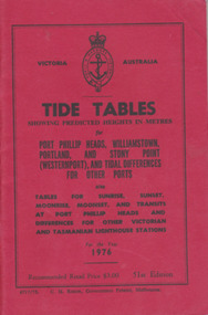
Booklet, Tide Tables, For the year 1976
Yearly publication showing predicted heights in metres for Port Phillip Heads, Williamstown, Portland and Stony Point (Westernport) and tidal differences for other Ports.This booklet provides tide and port information for the coastline of Victoria for the year 1976. It also has information on other aspects of weather such as wind, cloud and sea descriptions. These booklets were a useful reference for fishermen and those involved in boating along the coast of Victoria. They are published in digital form today.Sold at Stan McPhee Sports store Liebig St Warrnambool Vic showing local tides. Red card wrap around cover. 92 cream coloured pages held with 2 staples. Black print. Ports and harbour seal on the frontBooksellers stamp: ink. blue Stan McPhee Sports, green Liebig St Vic. red ...2953. 6717/75. C.H. Rixon, Government Printer, Melbourne. 51st Edition. Recommended price $3.00. Tables for Sunrise, Sunset/moonrise, moonset and transits at Port Phillip Heads & differences for other Victorian and Tasmanian Lighthouse stations.tide table, warrnambool tide table 1976, southern victorian tides