Showing 41 items
matching stony creek
-
 Orbost & District Historical Society
black and white photograph, 1977?
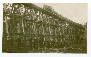
... . The Stony Creek Trestle Bridge was built in 1916 when the existing.... The Stony Creek Trestle Bridge was built in 1916 when the existing ...In 1977 great efforts were being made to preserve this bridge, the highest trestle bridge in Victoria at Stoney Creek. The Stony Creek Trestle Bridge was built in 1916 when the existing rail line from Melbourne to Bairnsdale was extended to Orbost. This 97km Bairnsdale to Orbost extension through rugged terrain was reputed to have been the most difficult rail project undertaken in Victoria. In service for over 60 years the bridge was damaged by bushfire in 1980, with the last train crossing in 1987. At 247m long and 20m high, it is the largest standing bridge of its kind in the State, and is listed on the Register of Historic Sites. Built of red ironbark and grey box timber, it is a fine example of the early engineering skills that utilised the resources and materials found on site.The Bairnsdale to Orbost rail line contains the most varied range of timber & timber composite bridges on any Victorian line. The Stoney Creek bridge is listed on the Victorian Heritage Register for its architectural and historical significance.A black / white photograph of a very large trestle bridge. a steam locomotive, with loaded goods trucks, is on the bridge. stoney-creek trestle-bridge railway east-gippsland-railway -
 The Beechworth Burke Museum
Photograph, Late 1900s
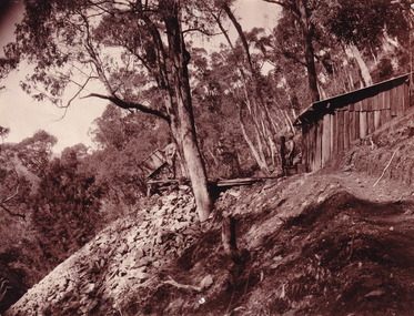
... and Stony Creek. These locations were set up due to speculative... and Stony Creek. These locations were set up due to speculative ...This photograph dating to the late 1900s depicts the entrance to a reef mine the in Beechworth division. The image depicts two men outside the entrance, which is covered by a hut, where one is standing near a mine cart. The mine car was used to haul soil from the mine. The Beewchworth divison consisted of 5 locations: Beechworth, Stanley, El Dorado, Hurdle Flat and Stony Creek. These locations were set up due to speculative fever that more gold could be found. In places such as El Dorado, Beechworth and Stanley there was profit, however Hurdle Flat and Stonry Creek, gold could not be found in the quantities that was required. By 1880 the Beechworth division was in depression due to the reserves being used up. However, in spite of the depression mining was continued until the late 20th Century.The search for gold is ingrained into the history of Victoria and therefore, images like this one which portray an open cut sluicing site can reveal important information for society and technology for the date when the photograph was taken. This image is of important historical significance for its ability to convey information about reef mining in the late 1900s. It also shows a location where reef mining was undertook which provides insight into the impact of reef mining on the environment at a time when it was done. This image is important for current research into the history of Beechworth , a town in Victoria's north-east. Therefore, this image has the capacity to be beneficial for research into society and the motivations of those living and working in this region during this period and therefore, has social significance. The Beechworth Burke Museum has additional images relating to reef mining and Beechworth which can be analysed and studied alongside images like this one.Sepia coloured retangular photograph printed on newspaper.Reverse: 7813beechworth, beechworth division, mining, reef mining, gold, gold mining, 1990 -
 Melton City Libraries
Photograph, Schutt and Barrie Flour Mills, 1969
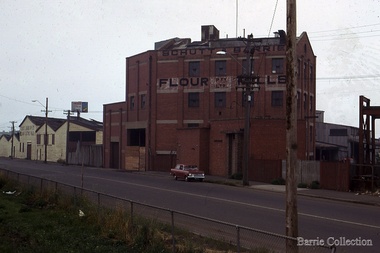
... Sir William Schutt. His mother was born a Clutha House, stony... Sir William Schutt. His mother was born a Clutha House, stony ...Arthur Henry Schutt. Born 18th July 1912 at Spotswood He was the third child of John Ralph and Mary Jane Schutt. His grandfather was the first librarian of the Victorian Law Courts and his uncle, William Schutt, was a lawyer who later became the Chief Justice Sir William Schutt. His mother was born a Clutha House, stony Creek Yarraville, a was one of ten children. John Schutt opened a chaff mill at the corner of Williamstown and Geelong Roads at West Footscray. The mill was placed on in an old quarry below the ground which saved much of the backbreaking labour of heaving sheaves of hay up into the machinery, the below ground location enable the hay to be fed directly into the railway trucks into the cutters. An elevator then carried the chaff up from the ground directly into the waiting transport, at a great saving in manpower. The chaff mill became on of the largest in Victoria employing more than forty men, and later moved into flour milling.Schutt and Barrie Flour Mills, Melton South site. Opposite this Mill was a Public Weighbridge. A rail siding crossed Brooklyn road to serve chaff mill. The rail line crossed west of the Methodist Churchlocal identities, agriculture -
 Halls Gap & Grampians Historical Society
Photograph - B/W, C 1931
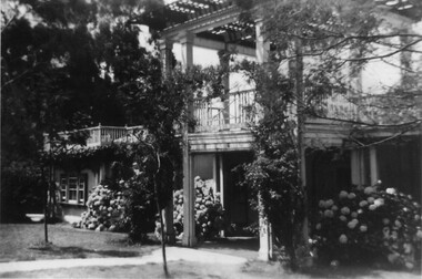
... by building a weir on Stony Creek and piping the water to a high... on Stony Creek and piping the water to a high holding tank ...A major rebuilding project took place. Brothers John & Thomas Morgan with local storekeeper Harold Goodwin Taylor designing and building a grand new Guest House with 22 bedrooms plus the original bungalows. Unheard of at the time the guests bedrooms had hand basins with hot & cold running water. This was achieved by building a weir on Stony Creek and piping the water to a high holding tank at the guest house. The dining room was a grand affair, a 4.5 metre high ceiling with beautiful gold leaf cornices, art deco ceiling and wall lights with feature plaster lights in the form of blue bells, wall to wall carpet and Kentia palms completed the picture. Ladies & gentlemen dressed for dinner, the ladies resplendent in their long evening gowns and jewellery would come down the stairway from the entrance hall to the lounge then the dining room. The tables were beautifully appointed with damask table cloths & fine silverware. The kitchen was well appointed with a huge coal fired range and a donkey for hot water. Milk & cream, bacon & pork, chicken & eggs together with vegetables were all home grown on the property. A large ballroom with a beautiful timber floor was the scene after dinner for many dances and party nights with guests from other establishments and locals joining in for the night. A huge fernery was also a feature of the gardens. During the day tennis parties would be held on the courts, together with horse riding and guided walks were taken out by local guide Gilbert Rogers.Photo of newly built Grampian Houseaccommodation, guesthouses, accommodation, grampian house -
 Eltham District Historical Society Inc
Photograph, Fay Bridge, Eastern boundary of former Warrandyte Aboriginal Reserve, North Warrandyte, 7 November 2016
... bank of the Yarra and its confluence with Stony Creek. Melway... bank of the Yarra and its confluence with Stony Creek. Melway ...Two bronze commemorative plaques on rocks, unveiled by Wurundjeri Tribe Council Elders, mark two eastern boundaries of the former Warrandyte Aboriginal Reserve on the north and south sides of the Yarra. This project was initiated by Nillumbik Reconciliation Group in close association with Reconciliation Manningham and the Wurundjeri Tribe Council, as a means of commemorating the last great corroboree of the Kulin Nation which was held at Pound Bend in March 1852. This plaque is on the Nillumbuk side of the Yarra, accessed via The Boulevard, North Warrandyte. The plaque is set on a rock approximately 50 metres before the turning circle at the end of The Boulevard. Plaque : Warrandyte Aboriginal Reserve This commemorative rock marks an eastern boundary of the former Warrandyte Aboriginal Reserve established in 1852. Centred on Pound Bend, it covered 1,908 acres on both sides of the Yarra River (Birrarung). That same year saw the last great gathering of the Kulin nation here in Wurundjeri country which was celebrated over two weeks with traditional performance and games. For a few years longer the reserve intermittently served as a ration station.With gold having been discovered at Warrandyte, the Wurundjeri were moved on again but ultimately secured a permanent home at Coranderrk, Healesville. A second commemorative plaque and rock is located on the opposite bank of the Yarra and its confluence with Stony Creek. Melway ref : 23 C 9 Unveiled by Wurundjeri Elder, Uncle Bill Nicholson on 23rd March 2013 Funded by the Robert Bridgford Indigenous Trust (Nillumbik Community Fund) with assistance from Manningham City Council Small Grants Program Ref: Monument Autralia https://monumentaustralia.org.au/themes/culture/indigenous/display/99680-warrandyte-aboriginal-reserve-fay bridge collection, 2016-11-07, aboriginal reserve, north warrandyte, plaques, warrandyte aboriginal reserve -
 Halls Gap & Grampians Historical Society
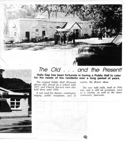
Newspaper - Photocopy
... was no exception, even in 1899-1900. Actually it was the locals of Stony... was no exception, even in 1899-1900. Actually it was the locals of Stony ...The article shows a photo of the original Hall's Gap Hall and the (then) new Hall, which was built in 1956. The copy has been scanned as two separate images (because it was too large for the scanner). the second image is stored under "Additional Images". HISTORY OF HALL'S GAP HALL: No village, no matter how small, could possibly survive without a public meeting place, and Hall's Gap was no exception, even in 1899-1900. Actually it was the locals of Stony Creek village, as Hall's Gap was known for a short time, who decided to hold a meeting to find out how much interest there was in building a town hall! They soon found out that support was overwhelming, as can be seen by the fact that 14 gentlemen nominated for a position on the committee of four! Several motions were moved at that meeting, mainly with reference to the materials to be used, for instance that no "wattle and daub", but rather slabs of bark and local bush logs be used. The walls were to be constructed of slabs, 6 feet long, 9 inches wide and two inches thick. Uprights were to be 9 feet high and at least 9 inches thick. Sheets of bark, all 32 of them, had to be 8 feet by 8 feet. Tenders for the building materials were called on 9 March 1899 and, 21 days later, McKeon Brothers won the right to supply all the material for the princely sum of 4 pounds 10 shillings. The size of the hall was to be 20 feet by 10 feet. The first hall served the community well for the next thirteen years, being regularly used as a place of entertainment and religious worship. The growing community soon realised the need for a larger venue, with better facilities, so once again the townsfolk rallied to raise funds for a new hall, realising their dream around 1913. In 1921 a schoolteacher was provided by the education department but as there was no school building she was expected to use the hall. Mainly lessons were held in the kitchen as it was much warmer than the hall itself, and it was not unusual for up to twenty children to be taught, ranging in age from 5 to 14 years. It was not until 1928 that an official school was built. 1955-56 were years of great excitement. The Progress Association was in charge of deciding the format for the new hall, and there were many rowdy meetings beforehand. Some members had much more vision than others, and to some the amount of money required seemed astronomical. Two hall committee members resigned over differences of opinion but amazingly it all came together in the end, albeit at a greater cost than had been anticipated. There is only one record of a grant being made for the building,1500 pounds, and it came for the Minister of Public Works. Estimated cost of the building was around 8,000 pounds, and when finally finished it was just slightly over, but bank charges and interest took it to well over 9,000 pounds. An electric light generator was included and lighting installed. The SEC electricity was connected in 1962.A copy of a newspaper article entitled 'The Old . . . and the Present!', which includes two photographs.buildings, halls -
 Eltham District Historical Society Inc
Photograph - Digital Photograph, Marguerite Marshall, Hawthorn hedges, Eltham-Yarra Glen Road, Kangaroo Ground, 3 October 2006
... and Diamond Creek. Until 1921, the Eltham-Yarra Glen Road beside... and Diamond Creek. Until 1921, the Eltham-Yarra Glen Road beside ...Hawthorn hedges are important reminders of Kangaroo Ground's Scottish heritage. They are Registered on the Victorian Heritage Register. They are "historically significant because the planting of hawthorn hedges reflects the adoption of Eurorpean farming techniques by the Kangaroo Ground population in the period following settlement and because the grid pattern of paddocks that the Hawthorn hedges define is very different to today's farm landscapes." Covered under Heritage Overlay, Nillumbik Planning Scheme. Published: Nillumbik Now and Then / Marguerite Marshall 2008; photographs Alan King with Marguerite Marshall.; p21 Hawthorn hedges bordering Kangaroo Ground’s gently rolling farmlands are important reminders of its Scottish heritage and are rare so close to Melbourne.1 As early as the 1840s newly arrived farmers from Scotland planted hawthorn hedges around their properties, to protect crops from the numerous kangaroos and wallabies. Many of these hedges survive today. These farmers had the good fortune to settle some of the most fertile land available for cropping in the Colony of Victoria. At that time the black volcanic soil could sustain an amazing two crops a year. By the mid 1850s, 500 acres (202ha) of wheat were growing in Kangaroo Ground. But the crops were threatened by kangaroos, which were so plentiful, that Surveyor-General, Robert Hoddle, named the district Kangaroo Ground in 1838. As post-and-rail fences proved inadequate barriers for the bounding kangaroos, the Scots planted hawthorn hedgerows as they had done in Scotland. Some also used the hedges to net birds, presumably for the table. Interestingly the farmers in the bordering townships of Panton Hill and Christmas Hills, did not plant hawthorn hedges around their properties. Perhaps it was because by the time they settled in the 1860s and 1870s most of the wildlife had been gunned down by residents.2 The canny Scots planted the hedges on public land outside their own farms, as the hedgerows could spread to about five yards (five m) in width. With this impenetrable barrier Kangaroo Ground’s industrious farmers flourished to gain the economic power that saw the Shire of Eltham governed from Kangaroo Ground for 79 years (1858-1937). The Scots jealously guarded their land, so hard to get in Scotland. That is why they refused to release any of it ‘for local roads to follow easier grades as was the case in surrounding districts where roads generally followed ridgelines or streams’.3 Instead the roads were built in accordance with the magnetic bearings of their first survey in 1847 whether that suited the steep topography or not. This could force traffic to diverge when wet through Greensborough and Diamond Creek. Until 1921, the Eltham-Yarra Glen Road beside Wellers Restaurant, ‘dipped down into the upper reaches of Stony Creek’.4 Later some corners were compulsorily cut for the increasing motor traffic. As late as the 1960s, corners were cut to form sweeping curves above and alongside the Kangaroo Ground Cemetery and opposite the Emergency Operations Centre. In the latter case, the farmers – understanding their hedgerows as important heritage – insisted upon their reinstatement to conform to the altered road alignment. Kangaroo Ground’s ancient manna gums also point to the district’s history and to that of the hedgerows. The Aboriginal people had transformed the original forests into grasslands with the fires they lit to attract kangaroos, (which the Scots were to exclude by planting hedgerows). But the Wurundjeri hunters left the gums (Eucalyptus vimminalis cygnetensis), on the grasslands as ‘stalking trees’ to hunt kangaroos. The hawthorn hedges in Kangaroo Ground were neglected for around 60 years from about the middle of the 20th century. Bushfires had created gaps and the hedgerows were not trimmed. Then in late 2005, local historian Mick Woiwod, formed a group to lobby the Nillumbik Shire to restore the hedges, which could last for many centuries. Some hedges in parts of Britain date back to AD 800.5 Although the original Scottish farmers have gone, the hedges are a reminder of when they flourished in the district, which has changed little in 150 years.This collection of almost 130 photos about places and people within the Shire of Nillumbik, an urban and rural municipality in Melbourne's north, contributes to an understanding of the history of the Shire. Published in 2008 immediately prior to the Black Saturday bushfires of February 7, 2009, it documents sites that were impacted, and in some cases destroyed by the fires. It includes photographs taken especially for the publication, creating a unique time capsule representing the Shire in the early 21st century. It remains the most recent comprehenesive publication devoted to the Shire's history connecting local residents to the past. nillumbik now and then (marshall-king) collection, eltham-yarra glen road, hawthorn hedgerow, kangaroo ground -
 Whitehorse Historical Society Inc.
Article, History a total mystery, 11/02/1997 12:00:00 AM
Little is known about aborigines who lived in the area now known as Boroondara.Little is known about aborigines who lived in the area now known as Boroondara.Little is known about aborigines who lived in the area now known as Boroondara.aborigines, mcwilliam, gwen, stonier-kipen, claire, city of boroondara -
Whitehorse Historical Society Inc.
Article, Little recognition of tribe's history, 18/02/1997 12:00:00 AM
A report commissioned by Boroondara Council.A report commissioned by Boroondara Council notes a lack of knowledge by the public about Aboriginal history and heritage.A report commissioned by Boroondara Council. aborigines, nicholson, bill, patten, herb, wurundjeri aboriginal tribe, mcwilliam, gwen, stonier-kipen, claire, city of boroondara -
 Whitehorse Historical Society Inc.
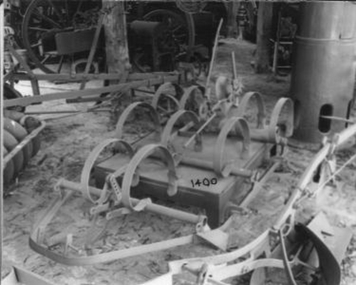
Machine - Cultivator
p34 'Old Farm Machinery in Australia' Society Ref.Horse drawn, hand operated Spring Tyne Orchard Cultivator. It can be paired with a similar cultivator. Has 7 tynes one disc at rear both adjustable. Depth of tyne into soil controlled by levers for light scratching to deep. The weight per tooth was 1/2 that of ordinary English harrow. Useful for rough stony ground.'Harvey' - on rear disc adjuster pivot.rural industry, orcharding -
Tarnagulla History Archive
Set of Maps (Mining & Local Area), various
David Gordon Collection. A set of mining documents, maps and plans: 1. Dunolly Deep Leads - showing location and names of deep lead gold deposits in region around Dunolly including at Tarnagulla and Newbridge. Geological Survey of Victoria, Department of Minerals and Energy. Bulletin No. 62, Map No. 4 Dunolly (770 x 485 mm). 2. Poseidon Lead (Facsimile) 3. Nick O Time Lead (Facsimile) 4. Happy Go Lucky Mine prospectus and plan (colour copy) 5. Jones Creek GM Co. (Raven & Gourlay's) Waanyarra - Prospectus (colour copy) 6. Poseidon Area Plan (colour copy) and Poseidon Area map (B&W copy). 7. Cross-section diagram of Spread Eagle Reef 8. New Birthday Gold Mine - area map (colour copy) and mine cross-section ( (colour copy). 9. Cross section of Poverty Reef, by Department of Mines (B&W copy, 2 parts on A2 paper) 10. Time-Lease Graph for Watts Reef, Specimen Reef, Stony Reef, Poverty Reef (second page in detail), created by Eric WIlkinson for Ref Mining NL, 1995 11. 1859 Plan of the Gold Workings & Township of Sandy Creek, Shewing the Mining Leases, Extended Claims & Machinery by R.J. McMillan, Mining Surveyor (B&W copy) 12. Longitundinal and Transverse Vertical Sections of Poverty Reef, Sandy Creek 1859, by R.J. McMillan, Mining Surveyor (B&W copy) 13. Tarnagulla Locality Plan (B&W copy) 14. Universal Grid Reference Map (Topographic) for Laanecoorie North (2 copies) 15. Universal Grid Reference Map (Topographic) for Inglewood South 16. Poverty Reef, Plan showing shafts and early tenements, created by Eric WIlkinson for Ref Mining NL, 1995 17. Locality Map of mining leases in Tarnagulla 18. Plan and Elevation of part of Poverty Reef, Sandy Creek, showing the claims and positions of the shaft. by R.J. McMillan, Mining Surveyor (Facsimile, composed of taped together components) 19.Plan and Elevation of part of Poverty Reef, Sandy Creek, showing the claims and positions of the shaft. by R.J. McMillan, Mining Surveyor (Facsimile, composed of taped together components)