Showing 44 items
matching suburban life
-
 City of Kingston
Photograph - Colour, 1998
The name Mordialloc was derived from the name Moody Yallock, which comes from the Bunurong language. The Bunurong Peoples are the Traditional Owners of this area. The name means “high water” or “high creek”. In 1839, colonial authorities declared the mouth of the creek, and an additional 830 odd acres as an Aboriginal Reserve, although this proclamation was never gazetted. The reserved land included part of the Carrum Carrum Swamp which was abundant with wild life and natural resources. Regular encroachments, including land sales which began in 1863, were made on the land until 1878 when the Reserve was declared closed, and the land was opened up to land sales. Market gardening and suburban house lots quickly began to develop, and Mordialloc became a renowned picnic and holiday site. Mordialloc Creek is a popular bay side destination for local and visitors, and is a site for boating, kayaking, fishing and swimming, along with many other activities.Colour photograph of Mordialloc Creek, looking inland.Small fishing and leisure boats are moored on either side of creek, with a view of the Mordialloc Bridge Hotel in the background.mordialloc, bunurong, traditional owners, suburbs, boats, fishing, waterways, hotel -
 City of Kingston
Photograph - Colour, Paul Tresize, 1998
The name Mordialloc was derived from the name Moody Yallock, which comes from the Bunurong language. The Bunurong Peoples are the Traditional Owners of this area. The name means “high water” or “high creek”. In 1839, colonial authorities declared the mouth of the creek, and an additional 830 odd acres as an Aboriginal Reserve, although this proclamation was never gazetted. The reserved land included part of the Carrum Carrum Swamp which was abundant with wild life and natural resources. Regular encroachments, including land sales which began in 1863, were made on the land until 1878 when the Reserve was declared closed, and the land was opened up to land sales. Market gardening and suburban house lots quickly began to develop, and Mordialloc became a renowned picnic and holiday site. Mordialloc Creek is a popular bay side destination for local and visitors, and is a site for boating, kayaking, fishing and swimming, along with many other activities.Colour photograph of Mordialloc Creek, looking inland. Boats are moored on either side of the creek and the Bridge Hotel is visible in the background.mordialloc, bunurong, traditional owners, suburbs, boats, fishing, waterways, hotel -
 City of Kingston
Photograph - Colour, Paul Tresize, 1998
The name Mordialloc was derived from the name Moody Yallock, which comes from the Bunurong language. The Bunurong Peoples are the Traditional Owners of this area. The name means “high water” or “high creek”. In 1839, colonial authorities declared the mouth of the creek, and an additional 830 odd acres as an Aboriginal Reserve, although this proclamation was never gazetted. The reserved land included part of the Carrum Carrum Swamp which was abundant with wild life and natural resources. Regular encroachments, including land sales which began in 1863, were made on the land until 1878 when the Reserve was declared closed, and the land was opened up to land sales. Market gardening and suburban house lots quickly began to develop, and Mordialloc became a renowned picnic and holiday site. Mordialloc Creek is a popular bay side destination for local and visitors, and is a site for boating, kayaking, fishing and swimming, along with many other activities.Colour photograph of Mordialloc Creek with boats moored on both sides of the street and Pompei's boat yard visible on the right hand side of the creek., Main Street and St Brigid's Catholic Church are visible in backgroundmordialloc, bunurong, traditional owners, suburbs, boats, fishing, waterways, hotel, church -
City of Kingston
Photograph - Colour, Paul Tresize, 1998
The name Mordialloc was derived from the name Moody Yallock, which comes from the Bunurong language. The Bunurong Peoples are the Traditional Owners of this area. The name means “high water” or “high creek”. In 1839, colonial authorities declared the mouth of the creek, and an additional 830 odd acres as an Aboriginal Reserve, although this proclamation was never gazetted. The reserved land included part of the Carrum Carrum Swamp which was abundant with wild life and natural resources. Regular encroachments, including land sales which began in 1863, were made on the land until 1878 when the Reserve was declared closed, and the land was opened up to land sales. Market gardening and suburban house lots quickly began to develop, and Mordialloc became a renowned picnic and holiday site. Mordialloc Creek is a popular bay side destination for local and visitors, and is a site for boating, kayaking, fishing and swimming, along with many other activities.Colour photograph of Mordialloc Creek with boats moored on both sides of the street and Pompei's boat yard visible on the right hand side of the creek., Main Street and St Brigid's Catholic Church are visible in background.mordialloc, bunurong, traditional owners, boats, fishing -
 Eltham District Historical Society Inc
Photograph - Digital Photograph, Alan King, Edendale Farm Homestead, 29 January 2008
Edendale Farm is Nillumbik Shire Council's environment centre situated in Gastons Road, Eltham between the railway and the Diamond Creek. The homestead on the property was built in 1896 and is of historical significance, being the subject of a Heritage Overlay under the Nillumbik Planning Scheme. The Edendale property was originally part of an extensive land purchase in 1852 from the Crown by pioneer Eltham farmer Henry Stooke. He initially purchased 51 acres and later expanded his holdings by purchasing another three adjacent Crown allotments extending northerly from Josiah Holloway's Little Eltham subdivision. Despite clearing the land, Stooke did not build on this property, choosing to live on his property "Rosehill" at Lower Plenty. In 1896 Thomas Cool, Club Manager of the Victoria Coffee Palace in Melbourne purchased 7 acres of the original Stooke land and built the house now known as Edendale. Cool did not farm the land, instead using it as a gentleman’s residence, retiring to Eltham at weekends. In 1918 he purchased an additional 7 acres but in 1919 he sold the property. Later owners included J.W. Cox, the Gaston family and D. Mummery. In the 1980s the Eltham Shire Council purchased the site for use as a Council depot, but this use did not proceed. Subsequently, it was used as the Council pound. The Edendale Farm Pet Education and Retention Centre was established in the summer of 1988/1989 and was set up to replace the existing dog kennels with a high standard pet retention centre. The design style of the building was established to compliment the features of the existing house. It was equipped with 10 retention pens, a veterinary room and a pet education area where school children and other interested parties learnt about pet care procedures. It was later developed into a community farm and was run by an advisory committee and in 2000 it became an Environment Centre. In early 2006 an advisory committee was established for the development of a master plan for future development at Edendale Farm. The committee included Russell Yeoman, a former long-time shire planner and founding member of the Eltham District Historical Society. At the time of filming the Master Plan and future for Edendale was about continuing to develop Edendale as a centre of environment learning and looking at expanding displays and school program, running a lot more of life-long learning and workshops around sustainable living. Covered under Heritage Overlay, Nillumbik Planning Scheme. Published: Nillumbik Now and Then / Marguerite Marshall 2008; photographs Alan King with Marguerite Marshall.; p101 A sharp turn from busy Wattletree Road by the railway line, brings a surprise. Only 1.4 km from Eltham’s centre, sheep feed, blissfully unaware of the hectic suburban activity so close by. At the entrance to the 5.6ha Edendale Farm is another surprise. A work of art that looks like huge tree trunks transformed into bowler and top-hatted men. The Fences Act 1968 by Tony Trembath with Mark Cain and John Doyle, 1996, is classified by the National Trust of Australia as having Regional Significance. The title refers to a government act on disputes between neighbors over the placement of fences and boundaries. This takes a ‘wry swipe’ at a community divided by trivial squabbles. It also celebrates making do with limited resources.1 Further along on the left, the office wall is decorated with a massive Eltham Copper Butterfly, designed by Robert Tickner and made by school children with used plastic bottles and other waste material. Nillumbik Council runs Edendale as an Environmental Education Centre, to help preserve and enhance the local environment. As early as 1988 the former Eltham Shire Council realised Edendale’s importance in meeting people’s needs, particularly of children, to enjoy farmland. The centre, with the Eltham North Reserve to the north - including remnant bushland and open parkland - makes up the major part of the public open space for this area. The council considers this area will become increasingly important to the local community for recreational use.2 Educational programs aim to encourage community involvement to ensure the long-term rehabilitation and protection of natural bushland areas. Edendale is used by people of all ages - from school children to adults - for environmental programs and workshops, as well as for recreation, to enjoy the domestic animals and to picnic. Edendale is also home to the Environmental Works staff who manage reserves and roadsides and support Nillumbik Friends environmental groups. The Friends propagate plants at the nursery, which grows indigenous plants and sells these to the public.3 The centre demonstrates the sustainable living the farm teaches, with features like solar hot water and drive lighting and for the fireplace, logs of recycled cardboard. Edendale has had a varied history as a dog pound and even as a retreat for Thomas Cool, Club Manager of the Victoria Coffee Palace in Melbourne. His single-storey weatherboard house built in 1896, which still stands, was grander than most homes in Eltham. Although such buildings were common in many other parts of Melbourne, Eltham’s poverty and remoteness did not encourage such construction. The Victorian rectangular-shaped house, with a corrugated iron roof and veranda, has elegant large rooms, leadlight windows, ceiling roses, two bay windows and ornately carved wooden fireplace surrounds. Cool bought seven acres (2.8ha) from pioneer Eltham farmer Henry Stooke’s 200 acre (81ha) farm, which he had bought from the Crown in 1852. In 1918 Cool bought an extra seven acres (2.8ha) but in 1919 sold the estate to farmer John Cox. In 1933 Cox sold Edendale to Mrs Elizabeth Gaston, after whom the road leading to the centre was named. The property was owned by several Gaston family members, who called it Edendale, then by a police constable, Douglas Mummery, until the Shire of Eltham bought it in 1970. Oddly Edendale was known as Mummery’s for almost 20 years, although Mummery owned it only for a short time.4 The shire used Edendale as a dog pound until amalgamation with other municipalities in 1996. The pound then moved to the Yan Yean Road, Plenty site, which had been used by the former Diamond Valley Shire Council. To the west and north the centre is bounded by Diamond Creek and on the east by the Melbourne-Hurstbridge railway line. Part of the Research creek forms the centre’s southern boundary.This collection of almost 130 photos about places and people within the Shire of Nillumbik, an urban and rural municipality in Melbourne's north, contributes to an understanding of the history of the Shire. Published in 2008 immediately prior to the Black Saturday bushfires of February 7, 2009, it documents sites that were impacted, and in some cases destroyed by the fires. It includes photographs taken especially for the publication, creating a unique time capsule representing the Shire in the early 21st century. It remains the most recent comprehenesive publication devoted to the Shire's history connecting local residents to the past. nillumbik now and then (marshall-king) collection, edendale farm -
 Eltham District Historical Society Inc
Slide - Photograph, Nillumbik Cemetery, 35 Main Street, Diamond Creek, 27 May 1990
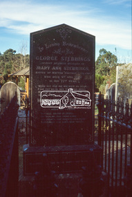
George Stebbing arrived from England in 1857 and settled at Eltham after a short period at Kangaroo Ground. His occupation is often listed as a farmer but he built a number of important buildings between the late 1860’s and the 1880’s. Those remaining include Shillinglaw Cottage, St. Margaret’s Church, Uniting church (formerly Methodist Church) and House at 84 Pitt Street, Eltham. From 1871 to 1875 he was a member of the Eltham Shire Council. Evelyn Observer and Bourke East Record (Vic. : 1902 - 1917), Friday 12 March 1909, page 2 ELTHAM. (FROM OUR OWN CORRESPONDENT.) One of the oldest inhabitants of Eltham passed away during the early hours of Saturday last in the person of Mrs Mary Ann Stebbings. Her residence here covered a period of some-what over 50 years. She had been a widow for some time, her husband, the late Mr. Geo. Stebbings, having pre-deceased her some fourteen or fifteen years. During the later years of her life, she had resided with her niece, Mrs. Wm. Williams. She lived a very retired life and is said to have owned a considerable amount of property, local and suburban, at the time of her death, at the age of 82 years. She was interred at Diamond Creek on Sunday, 7th inst. Local Cemetery Excursion Sunday 27 May 1990 departed Eltham Shire Office at 9.30am and finish mid afternoon. Visits to Eltham , Kangaroo Ground, Queenstown (Smiths Gully), Nillumbik (Diamond Creek), St Katherines (St Helena) Hurst family graves at Hurstbridge and a little known early cemetery at Greensborough. Attended by 20 members. In each case we were introduced to the cemetery with a brief talk. At Eltham, Frank Burgoyne gave us the benefit of his knowledge as a member of the cemetery trust and at Kangaroo Ground, Bruce Ness spoke in a similar capacity. The lunch stop was at Hurstbridge where we visited the Hurst family graves. The President of Nillumbik Historical Society, Jock Ryan, joined us at the Nillumbik (Diamond Creek) cemetery. He travelled on to St Katherines, St Helena, where he talked on the history of the church and cemetery. 35mm colour positive transparency (1 of 23) Mount - Agfachrome Agfa CS System black 8 dotsshire of eltham historical society, cemetery excursion, graves, activities, cemeteries, george stebbing, george stebbings, mary ann stebbing, mary ann stebbings, nillumbik cemetery -
 Eltham District Historical Society Inc
Slide - Photograph, Nillumbik Cemetery, 35 Main Street, Diamond Creek, 27 May 1990
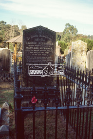
George Stebbing arrived from England in 1857 and settled at Eltham after a short period at Kangaroo Ground. His occupation is often listed as a farmer but he built a number of important buildings between the late 1860’s and the 1880’s. Those remaining include Shillinglaw Cottage, St. Margaret’s Church, Uniting church (formerly Methodist Church) and House at 84 Pitt Street, Eltham. From 1871 to 1875 he was a member of the Eltham Shire Council. Evelyn Observer and Bourke East Record (Vic. : 1902 - 1917), Friday 12 March 1909, page 2 ELTHAM. (FROM OUR OWN CORRESPONDENT.) One of the oldest inhabitants of Eltham passed away during the early hours of Saturday last in the person of Mrs Mary Ann Stebbings. Her residence here covered a period of some-what over 50 years. She had been a widow for some time, her husband, the late Mr. Geo. Stebbings, having pre-deceased her some fourteen or fifteen years. During the later years of her life, she had resided with her niece, Mrs. Wm. Williams. She lived a very retired life and is said to have owned a considerable amount of property, local and suburban, at the time of her death, at the age of 82 years. She was interred at Diamond Creek on Sunday, 7th inst. Local Cemetery Excursion Sunday 27 May 1990 departed Eltham Shire Office at 9.30am and finish mid afternoon. Visits to Eltham , Kangaroo Ground, Queenstown (Smiths Gully), Nillumbik (Diamond Creek), St Katherines (St Helena) Hurst family graves at Hurstbridge and a little known early cemetery at Greensborough. Attended by 20 members. In each case we were introduced to the cemetery with a brief talk. At Eltham, Frank Burgoyne gave us the benefit of his knowledge as a member of the cemetery trust and at Kangaroo Ground, Bruce Ness spoke in a similar capacity. The lunch stop was at Hurstbridge where we visited the Hurst family graves. The President of Nillumbik Historical Society, Jock Ryan, joined us at the Nillumbik (Diamond Creek) cemetery. He travelled on to St Katherines, St Helena, where he talked on the history of the church and cemetery. 35mm colour positive transparency (1 of 23) Mount - Agfachrome Agfa CS System black 8 dotsshire of eltham historical society, cemetery excursion, graves, activities, cemeteries, george stebbing, george stebbings, mary ann stebbing, mary ann stebbings, nillumbik cemetery -
 Melbourne Tram Museum
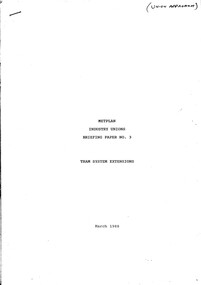
Document - Report, Public transport Unions, "Metplan - Industry Unions - Briefing Paper No. 3 - Tram System Extensions", "Metplan Discussion Paper", 1987 to 1988
Set of four photocopied documents, A4 sheets, stapled in top left hand corner concerning the development and adoption of Metplan, a Metropolitan Public Transport Industry Plan - see Reg Item 1186 for a discussion paper. .1 - "Metplan - Industry Unions - Briefing Paper No. 3 - Tram System Extensions" - March 1988 - 16 sheets - one of series of four documents to give Public Transport Unions where the industry is heading over the 15 years project life period. document looks at the Docklands Light Rail in London and bus services through the Central district of Melbourne. .2 - "Metplan Draft Document - January 1988" - 5 pages - prepared by Martin Gray - December 1987 - looking at training, working conditions, employment security, station staff and service delivery and job opportunities. .3 - "Metplan Discussion Paper" - 3 sheets - gives an overview of the suburban system, union's role, what could be done, electrification, rail cars, station development, dual voltage systems. .4 - "Metplan Discussion Paper" - table looking at the various measures, percentage changes, Metplan issues, services, finance and extension options. See also Reg item 2809 for a August 1988 paper and 345 for a detailed report.trams, tramways, ptc, metplan, unions, buses, tramways, public transport, suburban and underground -
 Narre Warren and District Family History Group
Book, Dot Morrison, 100 years in Skye 1850-1950, 2004
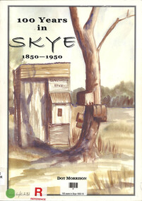
The book 100 Years in Skye, 1850-1950 by Dot Morrison explores the history of Skye in a detailed account of the area's development over a century, including its social, economic, and cultural changes. The book's illustrations, maps, and photographs offer a vivid portrayal of life in Skye during this period. Includes an index and bibliography.99 p.; 29 cmnon-fictionThe book 100 Years in Skye, 1850-1950 by Dot Morrison explores the history of Skye in a detailed account of the area's development over a century, including its social, economic, and cultural changes. The book's illustrations, maps, and photographs offer a vivid portrayal of life in Skye during this period. Includes an index and bibliography.skye (vic.), skye (vic.) -- history, skye (vic.) -- road names, wedge family, skye (vic.) -- murders, south lyndhurst state school -
 Broadmeadows Historical Society & Museum
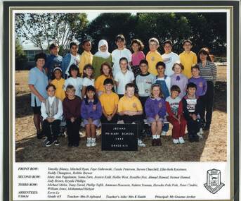
Photograph - School Photo, Fotek School Portraits, Jacana Primary School 1997 Grade 4/5, 1997
This 1997 photo of Jacana Primary School’s Grade 4/5 class captures a moment in the life of a community-focused school that served Melbourne’s northern suburbs from 1959 until the early 2000s, reflecting its strong educational and social values.This 1997 class photograph of Jacana Primary School’s Grade 4/5 students represents a significant moment in the history of a community-centered institution that served Melbourne’s northern suburbs from 1959 until the early 2000s. This image reflects the school’s enduring role in shaping local identity, fostering educational opportunity, and promoting social cohesion. As a visual record, it offers valuable insight into the educational practices, student life, and community values of the late 20th century in suburban Melbourne.A colour photograph taken in 1997 featuring students and teachers at Jacana Primary School. The photo is bordered by a black frame, with names neatly printed along the bottom on a white background. The entire photograph has been laminated for preservation.jacana primary school, education, photograph, group photograph, 1997, grade 4/5, timothy blaney, mitchell ryan, faye dabrowski, steven churchill, elke-beth koistinen, neddy changtave, robbie brewer, mary ann pagalanan, sonia zorn, jessica kidd, hollie west, rosalba nisi, ahmad hamad, neimat hamad, jody brown, krystle phillips, michael melia, dany david, phillip tafili, ammoun houssein, nahrin younan, herodia poki poki, peter cindric, william jones, mohammed mehyar, kevin le, mrs. d aylward, mrs. k smith, mr graham archer, cassie peterson -
 Broadmeadows Historical Society & Museum
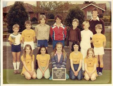
Photograph - School Photo, Jacana Primary School Bat Tennis Premiers 1979, 1979
This 1979 photograph of Jacana Primary School’s bat tennis premiers offers a nostalgic glimpse into a vibrant chapter of local school life. More than just a snapshot of sporting success, it reflects the values that underpinned the school’s ethos—participation, perseverance, and community pride. Founded in 1959, Jacana Primary served generations of families until its closure in the early 2000s, becoming a hub for both learning and local connection. The image stands as a testament to the school’s commitment to nurturing well-rounded students through both academic and extracurricular pursuits. It also serves as a cultural time capsule, capturing the spirit of a suburban Melbourne school community during a formative era in public education.This 1979 photograph of Jacana Primary School’s bat tennis premiers holds enduring cultural and historical value as a representation of the school’s commitment to holistic education and community engagement. The image is significant not only for documenting a moment of sporting achievement but also for illustrating the broader educational philosophy of the time—one that emphasised teamwork, resilience, and local pride. As a visual record from a school that served the Jacana community from 1959 until the early 2000s, it offers insight into the social fabric of suburban Melbourne during a period of growth and change. The photograph contributes to the collective memory of the area, symbolising the role of public schools as foundational institutions in shaping both individual lives and community identity.A colour photograph of Jacana Primary School’s 1979 bat tennis team. The students are dressed in various sports clothes and are arranged in rows. The teacher stands in the top right corner of the group.jacana primary school, education, photograph, group photograph, 1979, bat tennis -
 Broadmeadows Historical Society & Museum
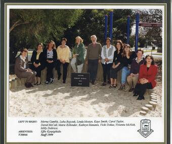
Photograph - School Photo, Fotek School Portraits, Jacana Primary School 1999 Staff Photograph, 1999
This 1999 photograph of staff at Jacana Primary School captures a significant moment in the history of a community-oriented institution that served Melbourne’s northern suburbs from 1959 until the early 2000s. More than just a staff portrait, the image reflects the enduring spirit of a school deeply embedded in its local context—one that championed educational access, fostered a strong sense of belonging, and played a vital role in shaping community identity. As a visual record, it offers valuable insight into the educational culture, staff dynamics, and broader social values of suburban Melbourne at the close of the 20th century. This 1999 photograph of Jacana Primary School staff holds considerable historical and cultural value as a visual record of a school that played a pivotal role in the educational and social fabric of Melbourne’s northern suburbs. Operating from 1959 until the early 2000s, Jacana Primary was more than an educational institution—it was a cornerstone of community life, fostering inclusion, resilience, and opportunity for generations of students and families. The image is significant for its ability to convey the ethos of the school at the close of the 20th century, reflecting broader trends in public education, suburban development, and community identity in Victoria. It offers insight into the people who shaped the school’s legacy and serves as a tangible link to the shared experiences and values of the Jacana community.A colour photograph depicting teachers at Jacana Primary School, taken in 1999. The image is bordered by a black frame and features a white strip along the bottom edge with names of individuals neatly printed. The Jacana Primary School logo is located in the bottom right-hand corner. Photograph is laminated. jacana primary school, education, photograph, group photograph, ms. carol taylor, 1999, merna gamble, luba bojczuk, mrs. linda mostyn, mrs. kaye smith, david mccall, marie killender, kathryn mananis, vicki dokas, mrs. vivien mcnish, ms. milly dobricic, effie kyrpigikidis -
 Broadmeadows Historical Society & Museum
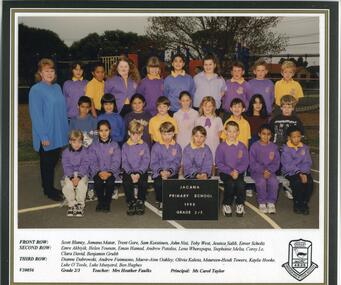
Photograph - School Photo, Fotek School Portraits, Jacana Primary School 1998 Grade 2/3, 1998
This 1998 class photograph of Grade 2/3 students at Jacana Primary School captures a meaningful moment in the legacy of a community-focused institution that served Melbourne’s northern suburbs from 1959 until the early 2000s. The image stands as a testament to the school’s lasting impact on local identity, its commitment to educational opportunity, and its role in nurturing social cohesion. As a visual document, it provides valuable insight into the educational environment, student experiences, and community values characteristic of suburban Melbourne in the late 20th century. The 1998 class photograph of Grade 2/3 students at Jacana Primary School holds historical and social significance as a visual representation of a community-oriented educational institution that served Melbourne’s northern suburbs from 1959 until the early 2000s. The image embodies the school’s enduring contribution to the development of local identity, the provision of accessible education, and the fostering of social cohesion within a diverse suburban context. It offers a valuable snapshot of late 20th-century educational practices, student life, and community values, reflecting broader societal trends in public schooling and suburban growth during this period. As such, the photograph is an important cultural artifact that contributes to the collective memory and heritage of the Jacana community.A colour photograph depicting students and teachers at Jacana Primary School, taken in 1998. The image is bordered by a black frame and features a white strip along the bottom edge with names of individuals neatly printed. The Jacana Primary School logo is located in the bottom right-hand corner. The entire photograph has been laminated for preservation purposes.jacana primary school, education, photograph, group photograph, scott blaney, jomana matar, trent gore, sam koistinen, john nisi, toby west, jessica salib, enver scholz, emre akbiyik, helen younan, eman hamad, andrew patalas, lena wharepapa, stephanie melia, corey le, clara david, benjamin grubb, dianne dabrowski, andrew fuimaono, maeve-aine oakley, olivia kaleta, maureen-heidi towers, kaylie hooke, luke o'toole, luke munyard, ben hughes, mrs. heather faulkes, ms. carol taylor, 1998, grade 2/3 -
Broadmeadows Historical Society & Museum
Book - Souvenir Book, Jacana Primary School, Jacana Primary School No. 4839 Silver Anniversary 1960 to 1985, 1985
History of the Jacana Primary School between the years 1960 to 1985.A5 Book 12 pages with card cover (white).non-fictionHistory of the Jacana Primary School between the years 1960 to 1985.jacana, education, jacana primary school, silver anniversary, 1960