Showing 194 items
matching vehicles army
-
 The Beechworth Burke Museum
Photograph, c. 1917
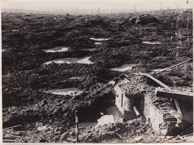
... to mud. Two army tank vehicles have been buried in the mud... to mud. Two army tank vehicles have been buried in the mud ...This photograph depicts the third battle of Ypres (Battle of Passchendaele). Depicted is a trench battlefield that has been turned to mud. Two army tank vehicles have been buried in the mud of the trenches. A single soldier stands in the background surveying the battlefield.After mid-1917, and following mutinies in the over-strained French Army, the British Forces had to assume an even greater role in the war on the Western Front. For Field Marshal Sir Douglas Haig, the British commander-in-chief, this provided an opportunity to launch an offensive that he had long wanted. Attacking from Ypres in Belgium, he planned to drive the Germans from the surrounding dominant ridges and even hoped to reach the Belgian coast. Following on the success at Messines in June, he unleashed his great attack on 31 July 1917. Fighting went on, often in appalling weather and despite crippling losses, until November. Finally, with the army stuck in muddy fields churned up by the artillery fire, the bloody offensive came to an untidy close. Many would afterwards call this offensive, actually a series of battles, after the name of the village that had become the last objective – 'Passchendaele'. In the Battle off Passchendaele, the 1st, 2nd and 3rd Australian Divisions captured Broodseinde Ridge on 4 October 1917. It was a vital victory. But, then it began to rain. Five days later the 2nd Australian Division suffered heavily in a further attack in the mud. Finally, on 12 October, another attack, involving the 3rd Division assisted by the 4th, was made against the village of Passchendaele atop the main ridge. In the face of heavy fire, the men fought in the mire while struggling to keep up with their artillery barrages. Ground was taken but it could not be held. In wretched conditions, with casualties mounting at an appalling rate, the Australians had to fall back. The troops were finally exhausted and could do no more; by 15 November they handed over to the Canadians.Black and white rectangular reproduced photograph printed on mate photographic paperReverse: 6523/ (A copyright and reproduction notice from the Australian War Museum, printed upside-down in blue ink)/military album, burke museum, beechworth, military vehicle, trenches, trench warfare, wwi, world war one, world war 1, ypres, belgium -
 8th/13th Victorian Mounted Rifles Regimental Collection
Photograph
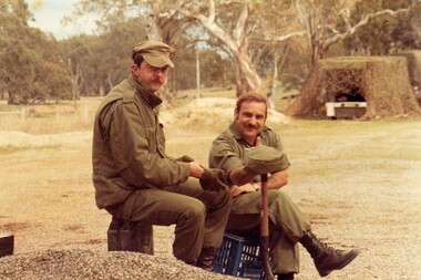
... army vehicles both on and off road and under combat conditions.... army vehicles both on and off road and under combat conditions ...A cadre staff of regular soldiers was posted to Army Reserve units to assist with training and administration. While many recruits could already drive when they joined 8/13 Victorian Mounted Rifles it took many hours of instruction and training before they were licenced to drive heavier, more complex army vehicles both on and off road and under combat conditions.Colour photograph of two members of Cadre Staff of ' A ' Squadron 8/13 Victorian Mounted Rifles during a driver training exercise 1986. camouflaged vrhicle in background." Corporal Potts, WO " Burnie " -
 Bendigo Military Museum
Photograph - PHOTOGRAPH, FRAMED & PHOTOGRAPHS, post 1970
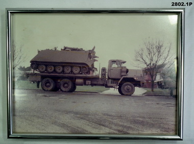
... a troop carrier vehicle. .3) Coloured photo of army vehicle No 12... towing a troop carrier vehicle. .3) Coloured photo of army ....1) Framed coloured photo of tray truck with personal carrier aboard, silver metal frame with glass front & khaki hanging cord. .2) Coloured photo of recovery vehicle towing a troop carrier vehicle. .3) Coloured photo of army vehicle No 12 in bush setting. .4) Coloured photo of land rover under camouflage net in bush setting..1) On stickers on back of frame: "Sgt Jones - APC Lift 9-10-11 Sep - 1984 - Cobram - Hay - 468 klms Trust No 5"photography-photographs, frame accessories, military history, passchendaele barracks trust -
 8th/13th Victorian Mounted Rifles Regimental Collection
Photograph
... , more complex army vehicles both on and off road and under..., more complex army vehicles both on and off road and under ...Private Roach was one of a number of female soldiers in ' A ' Squadron 8/13 Victorian Mounted Rifles who filled driver and administrative posts. While many recruits could already drive when they joined 8/13 Victorian Mounted Rifles it took many hours of instruction and training before they were licenced to drive heavier, more complex army vehicles both on and off road and under combat conditions.Colour photograph of large vehicle under camouflage netting. Private T. Roche is adjusting netting." Echelon in hide " -
 The Beechworth Burke Museum
Photograph, 1944
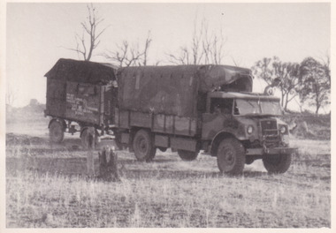
... Taken in 1944, the photograph depicts an Australian Army...-country Taken in 1944, the photograph depicts an Australian Army ...Taken in 1944, the photograph depicts an Australian Army vehicle with a trailer driving through bushland in Victoria. A secret experimental micro-wave radio station was established and tested in Stanley, Victoria by the Army Signal Detachment Unit during World War II. It was part of an experimental Ultra High Frequency (UHF) link between Melbourne and Sydney. At the time, it was highly classified. It intended to enquire into the hitherto unexplored transmission of micro-waves; that is, a radio signal which could only be transmitted by line of sight, and thus required hill-top to hill-top location.The photograph is historically significant as it pertains to World War II; the largest global conflict in history. This significance is enhanced by Australia's prominent involvement in campaigns across the Pacific, particularly on land in New Guinea and across the Huon Peninsula. It was also the first time that the Australian mainland came under direct attack by the Axis, with Japanese forces targeting north-west Australia and Sydney Harbour. These battles became Australia's largest and most complex offensives during the war. The record is also historically significant as it relates to the Royal Australian Corps of Signals, or "RA Sigs". This significance is strengthened by Australia's unique distinction of having the first established signal unit under the British Empire. This unit provides electronic warfare. They enable commanders to implement highly dynamic battle control against opposing forces by using a number of methods including radio, fibre optic, micro-wave, information systems and satellite links.Black and white rectangular photograph printed on matte photographic paper.Reverse: BMM5095.9 / Our outfit (fully mobile) / on the move / 32 /military album, army album, wwii, world war ii, army signal detachment unit, royal australian corps of signals, ra sigs, australian army, army truck, beechworth, stanley, victoria, melbourne, sydney -
 8th/13th Victorian Mounted Rifles Regimental Collection
Photograph - Sandwich and tea
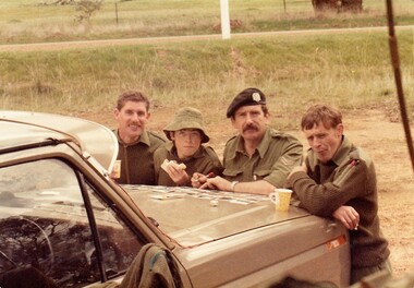
... army vehicles both on and off road and under combat... army vehicles both on and off road and under combat ...While many recruits could already drive when they joined 8/13 Victorian Mounted Rifles it took many hours of instruction and training before they were licenced to drive heavier, more complex army vehicles both on and off road and under combat conditions.Members of the Women’s Royal Australian Army Corps (WRAAC) were posted to Army Reserve units in the 1980s and 1990s. They were rarely posted to Armoured Fighting Vehicles (AFVs) but were invaluable in the A1 Echelon driving fuel, ammunition, ration and water supply vehicles. Shows citizen soldiers on weekend training.Colour photograph of 4 soldiers of ' A ' Squadron 8/13 Victorian Mounted Rifles at a road side break during a driving exercise, 1986. From left : Corporal M. Roberts, Private T. Roche, Corporal Tewson and Trooper Bowerman.military, citizen soldiers, vmr, uniform -
 8th/13th Victorian Mounted Rifles Regimental Collection
Photograph
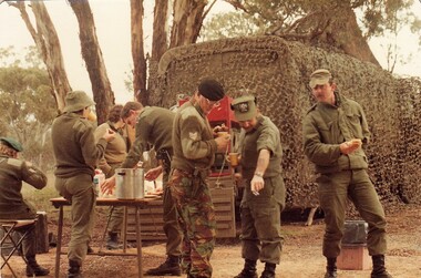
... army vehicles both on and off road and under combat conditions... army vehicles both on and off road and under combat conditions ...While many recruits could already drive when they joined 8/13 Victorian Mounted Rifles it took many hours of instruction and training before they were licenced to drive heavier, more complex army vehicles both on and off road and under combat conditions. Members of the Women’s Royal Australian Army Corps (WRAAC) were posted to Army Reserve units in the 1980s and 1990s. They were rarely posted to Armoured Fighting Vehicles (AFVs) but were invaluable in the A1 Echelon driving fuel, ammunition, ration and water supply vehicles. Two colour photographs of group of soldiers of ' A ' Squadron 8/13 Victorian Mounted Rifles at a meal break during a driving exercise, 1986. Considerable variation in dress and headgear. Green beret at left, Sergeant D. Reynolds; hat Private T. Roche; Black beret Sergeant H. Wilson; no hat Corporal M. Roberts ; peak Cap with badge Warrant Officer 2 Burnie; Peak cap Corporal Potts. -
 Bendigo Military Museum
Book - MILITARY, REFERENCE, Terry GANDER, "MILITARY ARCHAEOLOGY", 1979
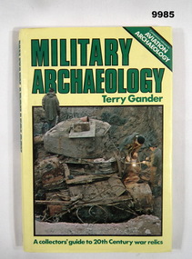
... persons working on a tank relic. Back - display of an army vehicle... - three persons working on a tank relic. Back - display of an army ...Hardcover book with dust cover. Hardcover - cardboard with yellow colour buckram. Gold colour print on spine. Dust cover - paper, with green and black colour print on front, spine and back. Illustrated - colour photographs - Front - three persons working on a tank relic. Back - display of an army vehicle. 156 pages - cut, plain, white colour paper. Illustrated black and white photographs, maps and diagrams. Retailers gold colour adhesive label - front endpaper. Retailer's information black print. "TECHNICAL BOOK & MAG. CO/ 289-299 SWANSTON STREET/ MELBOURNE 3000 663 3951"publication, book, military history, archaeology -
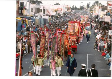 Bendigo Historical Society Inc.
Photograph - Bendigo Easter Fair
... . There are two army vehicles following behind Sun Loong, with spectators.... There are two army vehicles following behind Sun Loong, with spectators ...The first photograph is of the Bendigo Easter Parade making its way down Mitchell Street towards High Street and Pall Mall. This photograph shows the Bendigo Chinese Association walking as part of the parade, spectators along the side of the street and shows some of the shops along Mitchel Street. The second photo is taken from a similar position and shows various lions and a drum in the foreground, with Sun Loong weaving down the street behind them. There are two army vehicles following behind Sun Loong, with spectators crowding the street behind.bendigo chinese association, sun loong, chinese dragon, bendigo easter fair, bendigo easter parade, parades., mitchell st -
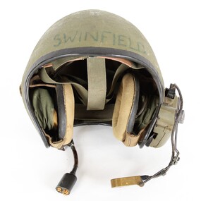 Montmorency–Eltham RSL Sub Branch
Headwear - Helmet, vehicle, intercom
... Black edge trimmed green fibreglass Army vehicle intercom... cable. Black edge trimmed green fibreglass Army vehicle intercom ...Worn by Swinfield in IraqWorn by Swinfield in IraqBlack edge trimmed green fibreglass Army vehicle intercom helmet. Adjustable head straps inside helmet, Adjustment strap for right earphone located on ouside of right ear. Earphones mounted inside helmet at each ear side. Voice microphone located at mounting on outside of the left ear connected by black cable to mounting on outside of left ear. Cable connection with clip for helemt connection to vehicle located at outside of left ear. Switch located on mounting on outside of left ear. Plastic mounting box located on ouside of the left ear. Brown leather sweat band on helmet straps on inside front of the helmet. Male and female connections on end of vehicle connection point.Swinfield marked on outside front of helmet. 34B marked on outside of helmet at rear. Roamwell Corp. with number SA-1552,6 marked on plastic mounting on outside of right ear. Front and back markings on microphone. M138/6 marked on back of microphone. ID label on connection point end of vehicle connection cable. -
 Bendigo Military Museum
Photograph - Johnson Ground Elevation Meter (JGEM) Survey Vehicle - Army Survey Regiment, Fortuna, Bendigo, c1960s
... Johnson Ground Elevation Meter (JGEM) Survey Vehicle - Army...Johnson Ground Elevation Meter (JGEM) Survey Vehicle - Army... Vehicle taken at the Army Survey Regiment, Fortuna, Bendigo... Vehicle taken at the Army Survey Regiment, Fortuna, Bendigo... Vehicle taken at the Army Survey Regiment, Fortuna, Bendigo ...This is a set of 16 photograph of the Royal Australian Survey Corps’ Johnson Ground Elevation Meter (JGEM) Survey Vehicle taken at the Army Survey Regiment, Fortuna, Bendigo. The JGEM vehicle was extensively used by RA Svy within Australia from the late 1960s. A limited number of Ground Elevation Meter (GEM) station wagon type vehicles were manufactured by General Motors Corporation (GMC) in the USA for the United States Geological Survey, Canada’s mapping agencies, RA Svy and National Mapping (Natmap). The GEM was a four-wheel drive, four-wheel steer vehicle. Four-wheel steering was necessary to avoid systematic errors caused by non-tracking of front and rear wheels on conventionally steered vehicles. The manufacturer substituted the rear axle with a front axle and connected them to form the four-wheel steering mechanism. The two Australian GEM vehicles, referred to as Johnson GEMs (JGEMs) were converted into right-hand drive. After delivery in 1964, acceptance Natmap and RA Svy testing and operator training was undertaken at the Army's School of Military Survey located at Balcombe, Victoria. A small fifth wheel was mounted on a cantilever arm suspension midway between the front and rear wheels on the right side of the vehicle. It was lowered to and raised from its operating position by use of a constant pressure air cylinder. A telescopic bar, suspended between the front and rear axles, provided the reference datum for the angle measurement. The wheel provided the velocity or distance signal through a pulse generator system. A sensitive pendulum mounted on this bar provided the angle measurement for each minute distance traversed. The JGEM contained electromechanical instruments used to determine relative elevations, by trigonometric principles, along a traversed path. These relative elevations were obtained through apparatus which measures the instantaneous angle of inclination of the road and the instantaneous velocity of the meter along such a path. Road routes over which the JGEM operated were planned so that each started and ended as near as practicable to an existing point of known elevation (formally referred to as a level traverse bench mark). The difference in height from the bench mark and the road surface alongside the JGEM’s fifth wheel was measured with a level and staff. Along each route, mapping control photo reference points where new elevation values were required were identified on aerial photographs. Under favourable conditions it was possible to survey as much as 160km in an ordinary working day. The first of RA Svy’s JGEM operations was undertaken in 1:250,000 scale map areas of Queensland. CPL John Hook was the JGEM’s main operator in the early 1970s undertaking operations covering 1:250,000 scale map blocks over northern Victoria and central NSW, each requiring 36 points (9 runs of photography and 4 points across. SPR Lyn Thompson and SPR Bob McDonagh teamed with CPL Hook on some of these JGEM operations. When RA Svy was integrated into the Royal Australian Engineers in 1996, the JGEM vehicle with the Survey Corps collection was donated to its museum. It is believed to be the last of the original manufactured fleet in existence. The JGEM has undergone extensive refurbishment to achieve roadworthiness and is currently housed at The Australian Army Museum of Military Engineering, Hoslworthy Barracks, NSW. It can be viewed by making an appointment with the museum’s curator.This is a set of 16 photograph of the Royal Australian Survey Corps’ Johnson Ground Elevation Meter (JGEM) Survey Vehicle taken at the Army Survey Regiment, Fortuna, Bendigo. The photographs were on 35mm slide film and were scanned at 96 dpi. They are part of the Army Survey Regiment’s Collection. .1) - Photo, colour, c1960s, Johnson Ground Elevation Meter (JGEM) Survey Vehicle .2) - Photo, colour, c1960s, JGEM instrumentation, on-board computer. .3) - Photo, colour, c1960s, JGEM instrumentation. .4) - Photo, colour, c1960s, JGEM instrumentation, on-board computer. .5) - Photo, colour, c1960s, JGEM tyre pressure controller .6) - Photo, colour, c1960s, JGEM rear doors, SGT Geoff Briggs. .7) - Photo, colour, c1960s, JGEM 5th wheel distance/angle measurement device in lowered position, SGT Geoff Briggs. .8) - Photo, colour, c1960s, JGEM 5th wheel distance/angle measurement device in lowered position. .9) & .10) - Photo, colour, c1960s, JGEM tyre pressure system, SGT Geoff Briggs. .11) - Photo, colour, c1960s, JGEM tyre pressure system. SGT Geoff Briggs. .12) - Photo, colour, c1960s, JGEM levelling scope, levelling staff, unidentified technicians. .13) & .14) - Photo, colour, c1960s, JGEM levelling scope, unidentified technician. .15) & .16) - Photo, colour, c1960s, probably survey operation adjusted height plotted on block base sheet. .1P to .16P - Some of the equipment is annotated on the frame of the 35mm slides.royal australian survey corps, rasvy, army survey regiment, army svy regt, fortuna, asr, surveying -
 Bendigo Military Museum
Photograph - Miss Golden North Charity Queen - 2LT Kathie Ryan Army Survey Regiment, Fortuna, Bendigo, 1985
... article with photo 6593.4P was published on page 12 of the Army... article with photo 6593.4P was published on page 12 of the Army ...This is a set of 12 photographs of the Army Survey Regiment’s winning entrant in the Miss Golden North Charity Queen quest - 2LT Kathie Ryan, taken on three occasions in 1985. The following article was compiled by the unit summarising her campaign. ‘On Friday 20 September 1985, 2LT Kathie Ryan of the Army Survey Regiment, Bendigo, faced a selection panel of a different kind. Kathie is an entrant in this years Miss Australia Quest and is sponsored by her unit. Together with seven other girls from Central Victora, Kathie vied for the Regional Title of Miss Golden North, held on 20 September 1985. With enthusiastic shouts of joy from the members of the Regiment present, Kathie Ryan was crowned Miss Golden North 1986. She is now one of 19 finalists contesting the title “Miss Victoria 1986”. “It has been a very rewarding experience being involved in raising money for such a worthwhile cause” said Kathie. “Organisations such as the Spastic Society, have a very important role in helping people with disabilities. To be involved with this society has been both enjoyable and a great learning experience”. The aim of the Miss Australia Quest is to raise funds for the Spastic Society of Australia. Kathie entered the Quest in March then, together with her committee, started to raise money. Over the next seven months, many fund-raising activities were conducted. These included an Open Day at the Army Survey Regiment, a Bingo night, several raffles, and several tin shakes in the streets of Bendigo as well a participating in several of the functions organised at a Regional or State level in the name of the Spastic Society. The total raised this year was in excess of $11,500. The Army Survey Regiment has now had 3 entrants in the Miss Australia Quest since 1981 and has raised over $23,000 for the Spastic Society in that time’ An abbreviated article with photo 6593.4P was published on page 12 of the Army Newspaper on 28 November 1985. Two articles with photographs were published in the Bendigo Advertiser Newspaper on 23 September and 30 October 1985. Clippings from these newspapers, a detailed breakdown of the funds raised during the campaign and the Army Survey Regiment’s Open Day Administrative Instruction are stored with these photographs. The Open Day was held on the weekend of 24-25 August 1985. Activities included static displays of armoured vehicles, map production displays, Army recruiting displays historical tours of Fortuna Villa, refreshments including Devonshire Teas, craft stalls, live music and children's rides.This is a set of 12 photographs of the Army Survey Regiment’s winning entrant in the Miss Golden North Quest - 2LT Kathie Ryan, taken on three occasions in 1985. The photographs were printed on photographic paper and are part of the Army Survey Regiment’s Collection. The colour and black and white photographs were scanned at 300 dpi. Included in this set are negatives of photo 6593.4P, 6593.5P and 6593.6P. .1) - Photo, black & white, Open Day 23-24 Aug 1985. Unidentified visitor on APC vehicle. .2) - Photo, black & white, Open Day 23-24 Aug 1985. Unidentified pipe band performs in front of APC vehicle. .3) - Photo, black & white, Open Day 23-24 Aug 1985. View of Fortuna Villa. .4) - Photo, black & white, Miss Australia Quest Presentation at All seasons Motor Inn 20 Sep 1985. 2LT Kathie Ryan crowned Miss Golden North Queen by former holder of the title Miss Celine Hull. Unidentified compere in background. .5) - Photo, black & white, Miss Australia Quest Presentation at All seasons Motor Inn 20 Sep 1985. 2LT Kathie Ryan reacts winning the Miss Golden North Queen. Winner of the Miss Golden North Charity Queen title Miss Noelene Earle is on her right. .6) - Photo, black & white, Miss Australia Quest Presentation at All seasons Motor Inn 20 Sep 1985. Title winners L to R: Miss Golden North Charity Queen - Noelene Earle, Miss North-West/Sunraysia & Charity Queen – Jo-Anne Collier and Miss Golden North Queen - 2LT Kathie Ryan. .7) & .8) - Photo, colour, Miss Australia Quest Presentation at All seasons Motor Inn 20 Sep 1985. 2LT Kathie Ryan is escorted to the ceremony dais by LT Greg Oaten. .9) - Photo, colour, Miss Australia Quest Presentation at All seasons Motor Inn 20 Sep 1985. 2LT Kathie Ryan with her escorts L to R: LT Greg Oaten and CAPT Neil Taylor. .10) - Photo, colour, Miss Australia Quest Presentation at All seasons Motor Inn 20 Sep 1985. Miss Golden North Queen 2LT Kathie Ryan with her organising committee L to R: SPR Sherri (Dally) Burke, WO2 Pat Lumsden, RSM WO1 Bob Mason, 2LT Kathie Ryan, MAJ Alex McLennan - President, SPR Gae (Robinson) Amato – Secretary, CPL Mick Minchin – Treasurer. .11) - Photo, colour, 1985. MAJ Alex McLennan presents 2LT Kathie Ryan with the Miss Golden North Queen prizes she had won at a celebration BBQ. In background L to R: SPR Wally Twidale, unidentified, SPR Dave Lambton-Young, SPR Jann (Caithness) Lambton-Young, unidentified, Mrs Pam Mason, WO2 Pat Lumsden. .12) - Photo, colour, 1985. L to R: MAJ Alex McLennan, Miss Golden North Queen 1985 Miss Celine Hull, CO LTCOL Jorge Gruszka, CPL Mick Minchin, Miss Golden North Queen 1986 2LT Kathie Ryan. 2x unidentified ladies in background double exposure.‘Miss Australia Quest 1985' annotated on cover sleeve. .7P to .11P – names annotated on back of photographs. ’15 October 1985’ annotated on back of photographs .7P to .9P is probably incorrect, based on other reports and newspaper articles. royal australian survey corps, rasvy, army survey regiment, army svy regt, fortuna -
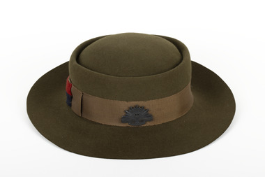 The Beechworth Burke Museum
Uniform - Hat, 1939
This hat was worn by Joan Cahill during her service in the AWAS, where she served in the Signals Branch and rose to the rank of Corporal. The AWAS was formed in 1941, and its main objective was to support the Australian army in various ways. Over 24,000 women served in the AWAS, performing critical support roles such as clerical work, vehicle maintenance, and communications. The Signals Branch, which Joan Cahill served in, was responsible for providing reliable and secure communication services between the Australian army and Allied forces.Khaki women's army hat with grosgrain band wrapped around the circumference with a small metal rising sun attached.burke museum, beechworth, army service, army uniform, joan cahill, australian women's army service, ww2, wwii, world war two -
 The Beechworth Burke Museum
Photograph, 1944
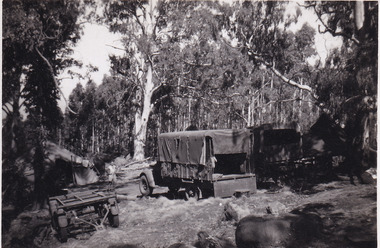
Taken in 1944, the photograph depicts two trucks and a trailer park at an undisclosed location inside the Stanley forest. An unidentified young man is standing in the background. There are also two tents installed on either side of the vehicles. A secret experimental micro-wave radio station was established and tested in Stanley, Victoria by the Army Signal Detachment Unit during World War II. It was part of an experimental Ultra High Frequency (UHF) link between Melbourne and Sydney. At the time, it was highly classified. It intended to enquire into the hitherto unexplored transmission of micro-waves; that is, a radio signal which could only be transmitted by line of sight, and thus required hill-top to hill-top location.The photograph is historically significant as it pertains to World War II; the largest global conflict in history. This significance is enhanced by Australia's prominent involvement in campaigns across the Pacific, particularly on land in New Guinea and across the Huon Peninsula. It was also the first time that the Australian mainland came under direct attack by the Axis, with Japanese forces targeting north-west Australia and Sydney Harbour. These battles became Australia's largest and most complex offensives during the war. The record is also historically significant as it relates to the Royal Australian Corps of Signals, or "RA Sigs". This significance is strengthened by Australia's unique distinction of having the first established signal unit under the British Empire. This unit provides electronic warfare. They enable commanders to implement highly dynamic battle control against opposing forces by using a number of methods including radio, fibre optic, micro-wave, information systems and satellite links. The record has strong research potential. This is due to the ongoing scholarly and public interest in war, military history, the ANZAC legend, and the continuing existence of the RA Sigs. The historic context of this record can provide insight into Australia's history, military, technological innovation and advancements, as well as national economic, defence and foreign policies after 1945.Black and white rectangular photograph printed on matte photographic paper.Reverse: BMM5095.8 /military album, army album, wwii, world war ii, army signal detachment unit, royal australian corps of signals, ra sigs, stanley, army truck, victoria, beechworth, melbourne, sydney -
 The Beechworth Burke Museum
Photograph, 1944
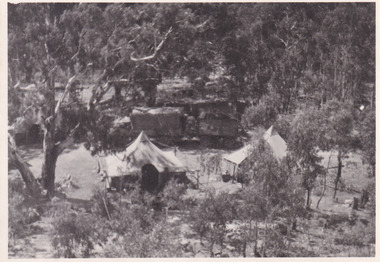
Taken in 1944, depicted is an aerial view of an Australian military camp set up at Mt. Stanley in Victoria. There are two large tents along with a vehicle and trailer surrounded by bushland. A secret experimental micro-wave radio station was established and tested at this site by the Army Signal Detachment Unit during World War II. It was part of an experimental Ultra High Frequency (UHF) link between Melbourne and Sydney. At the time, it was highly classified. It intended to enquire into the hitherto unexplored transmission of micro-waves; that is, a radio signal which could only be transmitted by line of sight, and thus required hill-top to hill-top location.The photograph is historically significant as it pertains to World War II; the largest global conflict in history. This significance is enhanced by Australia's prominent involvement in campaigns across the Pacific, particularly on land in New Guinea and across the Huon Peninsula. It was also the first time that the Australian mainland came under direct attack by the Axis, with Japanese forces targeting north-west Australia and Sydney Harbour. These battles became Australia's largest and most complex offensives during the war. The record is also historically significant as it relates to the Royal Australian Corps of Signals, or "RA Sigs". This significance is strengthened by Australia's unique distinction of having the first established signal unit under the British Empire. This unit provides electronic warfare. They enable commanders to implement highly dynamic battle control against opposing forces by using a number of methods including radio, fibre optic, micro-wave, information systems and satellite links. The record has strong research potential. This is due to the ongoing scholarly and public interest in war, military history, the ANZAC legend, and the continuing existence of the RA Sigs. The historic context of this record can provide insight into Australia's history, military, technological innovation and advancements, as well as national economic, defence and foreign policies after 1945.Black and white rectangular photograph printed on matte photographic paper.Reverse: BMM5095.11 / Our camp / From the top. / (?) (?) /military album, army album, australian royal corps of signals, army signal detachment unit, mt. stanley, victoria, beechworth, wwii, world war ii, melbourne, sydney -
 Phillip Island and District Historical Society Inc.
Photograph, Harry Bradley - Phillip Island Identity
Harry Bradley was a local Identity. Born in Yorkshire, England, 8/4/1916. Joined the Australian Army 19/5/1941 living in Cowes Phillip Island Victoria.Historical491-01: Harry Bradley an Australia Army Portrait - WWII 491-02: Harry Bradley & Ted Walton, very close fishing mates 491-03: Original House of Bradleys, opposite Race Track?? Ford Vehicle. Now Beachcomber Estate 491-04: Harry Bradley working on the 1st Phillip Island Bridge 491-05: Harry Bradley's parents - Father - Edwin and Mother who was killed by a bull 491-06: Harry Bradley - Equal 1st Competition at the Lang Lang Gun Club 491-07: Elsford Guest House - Post Card 491-08: Map of Phillip Island - Post Card Also DVD supplied with 491-01 to 06 on it.As Above with Harry's details listed on 491-01harry bradley, ted walton, edwin bradley, lang lang gun club, elsford guest house, phillip island map -
 Bendigo Military Museum
Administrative record - "Project Cutlass" - Project Report Mapping Control Survey of New Ireland (PNG), Major SW Snow RASvy Corps, 1957
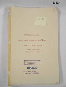
Item .1 "Project Cutlass" - Project Report Mapping Control Survey of New Ireland (PNG) is a report by the Project Officer Major SW Snow RASvy Corps. The Project commenced in August 1956 and concluded 29 Nov 1957. Traversing and Base line measurement used vehicles and two ships and included nearby islands. Includes two photographs. Item .2 Photograph of Bob Skitch Project Cutlass 1956/57 with theodolite Item .3 Photograph of Chas Beach project Cutlass 1957 Patlangat West Base (cemetery). 6353.1 Manilla Folder containing 49 foolscap sized loose page paper report. 12 pages of Intital report followed by 37 pages of Annexes and Appendices. Last page is map of Project Area. 6353.2 B/W Photograph Bob Skitch with Wild T2 Theodolite Project Cutlas 1956/1957 6353.3 B/W Photograph Chas Beach PATLANGAT WEST BASE (Cemetary) Project Cutlass 1957"Aug 56" on front coverroyal australian survey corps, rasvy, fortuna, army survey regiment, army svy regt, asr -
 Bendigo Military Museum
Photograph - Military Funeral for SSGT Peter Dew, Army Survey Regiment, Fortuna, Bendigo, 1977
This is a set of five black & white photographs of troops from the Army Headquarters Survey Regiment undertaking ceremonial drill at the military funeral for SSGT Peter Dew in 1977. The location of the funeral service was at Fortuna, Bendigo. He was buried at Bendigo Cemetery in Quarry Hill. Peter Dew died in a tragic accident at home. He was fondly remembered as one of Lithographic Squadron’s colourful personalities. See item 6243.7P for photos of Peter Dew at work in Lithographic Squadron. The "Super Animal of the Year" Peter Dew Memorial Award was an award presented to a member of the squadron for a crude act. To view a photo of this award, refer to item 6230 of the Victorian Collections. This is a set of five black & white photographs of troops from the Army Headquarters Survey Regiment undertaking ceremonial drill at the military funeral for SSGT Peter Dew in 1977. The photographs were printed on photographic paper and are part of the Army Survey Regiment’s Collection. The photographs were scanned at 300 dpi. .1) - Photo, black & white, 1977. Unidentified soldiers and civilians. .2) - Photo, black & white, 1977. In front of the tennis court gates: John McCulloch. Remainder unidentified. .3) - Photo, black & white, 1977. Rifle party rear rank right marker: Russ Mollenhauer. Front rank rifle party commander next to right marker: Greg Kidman. Pall bearers in front of vehicle L to R: Dave Miles, Dick Barwald. Remainder unidentified. .4) - Photo, black & white, 1977. Rifle party commander: Greg Kidman. Right file front to back: Russ Mollenhauer, Peter Breukel, Bill Jones, John Anderson. Remainder unidentified. Left file front to back: unidentified (x2), Rhys De Laine, Frank Lenane, Josh Degroot, Gary Drummond. .5) - Photo, black & white, 1977. Left of minister: Alan Toogood. On right of tree L to R: Max Neil, Bob Hayden, Dave Malligan, Le-Anne (Smallshaw) Shirley, Stan Vote. Remainder unidentified.No personnel are identified.royal australian survey corps, rasvy, army survey regiment, army svy regt, fortuna, asr -
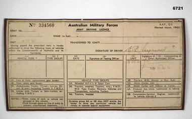 Bendigo Military Museum
Document - DRIVERS LICENCE, ARMY
... of vehicles. Brown coloured Army driving licence with white paper ...Army Driving Licence issued to service men/women to authorise the driving of military vehicles.Brown coloured Army driving licence with white paper and black writing. Folds into 3 to make wallet or pocket size.Licence No. 334560. Unit "38 Inf Bn" stamped, signature of driver, rank and full name too faded to decipher. Signature may be E.P. Seymour. Headed Australian Military Forces Army Driving Licence and lists types of vehicles.passchendaele barracks trust, drivers licence, 38th battalion -
 Lara RSL Sub Branch
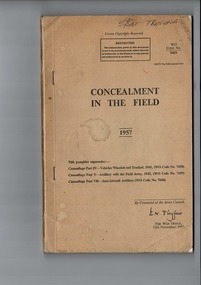
handbook, Concealment In The Field, 15th November 1957
U.K. Government Publication RESTRICTED65 year old War Department Publication.Handbook - Concealment In The Field. WO Code Number 9459 Dated 1957. RESTRICTED. Light Brown Thin cardboard cover , front, Back and spine . Enclosed off white 172 pages. Handbook - Concealment In The Field. WO Code Number 9459. 1957. This pamphlet supersedes : Camouflage Part IV - Vehicles Wheeled and Tracked, 1941 (WO Code 7658) - Camouflage Part V - Artillery with Field Army , 1942, (WO Code 7659) - Camouflage Part VII - Anti-Aircraft Artillary. (WO Code 7660). The War Office , 15th November 1957.user manual, concealment in the field -
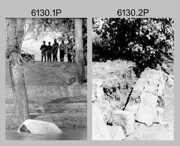 Bendigo Military Museum
Photograph - Vehicle in Lake Incident - Army Survey Regiment, Fortuna, Bendigo, 1986
... Vehicle in Lake Incident - Army Survey Regiment, Fortuna...Vehicle in Lake Incident - Army Survey Regiment, Fortuna... a vehicle from the lake at the Army Survey Regiment, Fortuna ...This is a set of 12 photographs of contractors removing a vehicle from the lake at the Army Survey Regiment, Fortuna, Bendigo in September 1986. The Ford XB panel van belonging to WO2 Ted Burgess rolled down the embankment during the night from the SGTs Mess carpark. Despite written off by the insurance company, the panel van was remarkably restored by Ted to roadworthy condition and driven in to Fortuna with a shark’s fin mounted on its roof. This incident is covered in more detail in page 152 of Valerie Lovejoy’s book 'Mapmakers of Fortuna – A history of the Army Survey Regiment’ ISBN: 0-646-42120-4.This is a set of 12 photograph of a civilian vehicle being removed from the lake at Army Survey Regiment at Fortuna, Bendigo, September 1986. The photographs were on 35mm negative film and were scanned at 96 dpi. They are part of the Army Survey Regiment’s Collection. .1) to .3) - Photo, black & white, 1986. Vehicle removal from lake. .4) - Photo, black & white, 1986. Vehicle removal from lake, Neil Morgan in foreground. .5) to .8) - Photo, black & white, 1986. Vehicle removal from lake. .9) to .10) - Photo, black & white, 1986. Vehicle removal from lake, Neil Morgan on right. .11) to .12) - Photo, black & white, 1986. Vehicle removal from lake.No personnel are identified. Annotated with date on negative sleeve.royal australian survey corps, rasvy, army survey regiment, army svy regt, fortuna, asr -
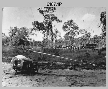 Bendigo Military Museum
Photograph - Bell 47G-2 helicopter used in Royal Australian Survey Corps Field Operations, c1965
This is a set of four photographs of Bell 47G-2 helicopters used in Royal Australian Survey Corps Field Operations. c1965. From 1957, helicopter transport of survey parties revolutionised transport in remote areas. The most common helicopter used by the Royal Australian Survey Corps at this time was the civilian Bell 47G-2 and the Sioux, the Australian Army’s’s equivalent. equivalent. From 1964 an Aerodist MRC2 airborne Electronic Distance Measuring (EDM) system was extensively used for topographic surveys over long distances by trilateration to replace traverse requiring survey station intervisibility. In 1965 the command field survey unit personnel attached to the Army Survey Regiment’s Topographic Squadron were used mainly in support roles such as station clearing, tower operations, station monumenting, Aerodist computations, forward base operations, geodetic observations on the north-south traverse and logistic support for Remote teams. .1P is a photo of a civilian Bell 47G-2 helicopter Registration / Serial VH-UTB owned by Helicopter Utilities from Mascot, NSW c1965. In the background of this photograph is three personnel and vehicles at a field survey camp. The left-hand vehicle is a Willys Jeep with trailer and on the right is probably a Truck, 2 1/2 ton, 6x6, General Service GMC. The Bell 47G-2: VH-UTB was destroyed, and its pilot killed in tragic circumstances during a civilian survey operation on Cape York Peninsula in June 1966. .2P is a photo of a a civilian Bell 47G-2 helicopter Registration / Serial VH-IHB taken in Wyndham, WA. As the letters ‘TAA’ appear on the fuselage, the helicopter was charted from Trans Australian Airways. .3P is a photo of a Bell 47G-2: VH-UTC with survey camp in background. .4P is a photo of a Bell 47G-2 equipped with floats and unidentified personnel loading stores, possibly in Darwin. Acknowledgement: Royal Australian Survey Corps – Aerodist Years 1964-1975 Version 2021.0 Authored by Peter Jensen.This is a set of four photographs of civilian Bell 47G-2 helicopters used in Royal Australian Survey Corps Field Operations. c1965. The photographs were printed on photographic paper and are part of the Army Survey Regiment’s Collection. The photographs were scanned at 300 dpi. .1) - Photo, black & white, c1965, Bell 47G-2 helicopter: VH-UTB with survey camp in background. .2) - Photo, black & white, c1965, Bell 47G-2 helicopter: VH-IHB with survey station in foreground. .3) - Photo, black & white, c1965, Bell 47G-2 helicopter: VH-UTC with survey camp in background. .4) - Photo, black & white, c1965, Bell 47G-2 helicopter: Unidentified personnel loading stores possibly in Darwin..2P – annotated on bottom of photo ‘Wyndham Area – Helicopter drops observing party’ The other photographs are not annotated.royal australian survey corps, rasvy, army survey regiment, army svy regt, fortuna, asr, surveying -
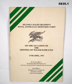 Bendigo Military Museum
Programme - PROGRAMME, BARRACKS OPENING, 1993
... / 17th APRIL 1993". 2. "THE AUSTRALIAN ARMY/ WHEELED/ ARMOURED.../ 17th APRIL 1993". 2. "THE AUSTRALIAN ARMY/ WHEELED/ ARMOURED ...1. "SECOND CAVALRY REGIMENT/ ROYAL AUSTRALIAN ARMOURED CORPS/ ON THE OCCASION OF/ THE/ OPENING OF THE WALER BARRACKS/ 17th APRIL 1993". 2. "THE AUSTRALIAN ARMY/ WHEELED/ ARMOURED/ FIGHTING/ VEHICLE."1. Programme - cover, cardboard, black and green print on front cover with illustration of eagle and rod crest of Second Cavalry Regiment, Royal Australian Armoured Corps. 16 pages - cut, plain, off white paper, illustrated - black and white photographs. Stapled - metal. 2. Leaflet - white glossy paper, Gold, green and white print on front. Colour photographs - back cover and inside leaflet.programme, military history, ceremonial, second cavalry regiment -
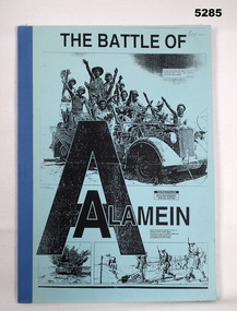 Bendigo Military Museum
Book - BOOK - facsimile, The Australian Newspaper - with Assistance of the "Staff of Central Army Records", "THE BATTLE OF ALAMEIN.", c1992
The Battle of Alamein - The Australian Casualties. The Australian`, The Weekend Australian - 50th Anniversary Special Edition. Honour Roll and Newspaper Articles.SOFT COVER BOOK - FOLIO FACSIMILE - Cloth tape binding. Cover - thin cardboard, front cover - black print on blue background, illustrated in black print three photographs - top/troops in a vehicle, bottom/ tanks and soldiers advamcing. Pages - paper, cut, plain white. Illustrated black and white copies of photographs. Owners stamp - inside front cover.Inside front cover - owner's stamp black ink "Mr W.J. HAMMILL, A.A.I.M./ PO Box 76, KANGAROO FLAT/ VICTORIA, 3505, AUSTRALIA"books, history, ww2 -
 Bendigo Military Museum
Photograph - Staff Retirement - Army Survey Regiment, Fortuna, Bendigo, c1989
These two photos were most likely taken in the volleyball court area of the Army Survey Regiment, part of the grounds of Fortuna, Bendigo, in c1989. The occasion was probably to farewell SSGT Kevin Boehm, who was a cartographic draughtsman, after 22 years of service in the ADF. It is likely Bendigo Toyota was approached to loan their miniature Toyota Tarago; a vehicle used for marketing purposes. The novelty of this quirky “drive past” event was that Kev was well known as a part-time car salesman and often took the opportunity of assisting new staff in buying a car. Kev was a qualified pilot and often took time on weekends to take unit staff and their families on recreational flights over Bendigo and Albury-Wodonga. His other claim to fame was he was “charge happy”, a tendency to prefer charges against offending soldiers rather than offer them a warning.These two photos were most likely taken in the volleyball court area of the Army Survey Regiment, part of the grounds of Fortuna, Bendigo, in c1989. The photographs were on 35mm negative film and were scanned at 96 dpi. They are part of the Army Survey Regiment’s Collection. .1) and .2) - Photo, black & white, c1989, SSGT Kevin Boehm. No personnel are identifiedroyal australian survey corps, rasvy, army survey regiment, army svy regt, fortuna, asr -
 Bendigo Military Museum
Photograph - Lithographic Squadron Regimental Training, Army Survey Regiment, Bendigo, 1989
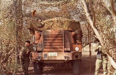
This is a set of 24 photographs of Army Survey Regiment’s Lithographic Squadron personnel undertaking regimental training in an unknown location in April 1989. The purpose of the training was probably to provide personnel a practical knowledge of navigation and map reading, RATEL and Survival in the Field, vehicle camouflage, teamwork and leadership. The training did not include infantry and minor tactics due to the absence of weapons. Although these photos are not annotated other than the month and year, most personnel are positively identified.This is a set of 24 photographs of personnel from Lithographic Squadron, Army Survey Regiment, Fortuna, Bendigo, undergoing regimental training in April 1989. The photographs were on 35mm negative film and scanned at 96 dpi. They are part of the Army Survey Regiment’s Collection. .1) - Photo, black & white, 1989, background L to R: Frank Lenane, Bill Jones, foreground L to R: Gavin McLean, Colin Yeats, Peter Dillon. .2) - Photo, black & white, 1989, Rhys De Laine. .3) - Photo, black & white, 1989, L to R: Peter Breukel, Colin Yeats. .4) - Photo, black & white, 1989, L to R: Colin Yeats., Peter Dillon. .5) - Photo, black & white, 1989, L to R: Graeme Spong, Gavin McLean, unidentified (x2), Peter Breukel, Steve Burke, Bill Jones, Colin Yeats. .6) - Photo, black & white, 1989, L to R: Graeme Spong, Bill Jones, Colin Yeats, Peter Dillon, Peter Breukel, Steve Burke, Colin Yeats. .7) - Photo, black & white, 1989, L to R: Graeme Spong, Bill Jones, Colin Yeats, Peter Dillon, .8) - Photo, black & white, 1989, Colin Yeats. .9) - Photo, black & white, 1989, L to R: Gavin McLean, Colin Yeats. .10) - Photo, black & white, 1989, L to R: Steve Burke, Peter Breukel, Colin Yeats, unidentified. .11) - Photo, black & white, 1989, L to R: Steve Burke, Peter Breukel. .12) - Photo, black & white, 1989, L to R: Peter Breukel, Steve Burke. .13) - Photo, black & white, 1989, Craig Hersant. .14) - Photo, black & white, 1989, L to R: Rob Bogumil, Darren Maher, Paul Baker, Rob Jones, Shona Hastie, unidentified, Chad Hardwick. .15) - Photo, black & white, 1989, L to R: Chad Hardwick, unidentified, Rob Bogumil, Rob Jones, Darren Maher, unidentified, Paul Baker. .16) - Photo, black & white, 1989, L to R: Rob Bogumil, Darren Maher, Chad Hardwick, Rob Jones, unidentified (x2), Paul Baker. .17) to .22) - Photo, black & white, 1989, unidentified personnel applying camouflage to truck. Shona Hastie in truck, .23) - Photo, black & white, 1989, L to R: LT Dave Weston, LT Craig Hersant, Trevor Osborne, Bill Jones. .24) - Photo, black & white, 1989, L to R: Andrew Arman, unidentified, Peter Dillon, Steve Burke, Colin Yeats, Peter Breukel. No personnel are identified. Annotation dated April 1989.royal australian survey corps, rasvy, army survey regiment, army svy regt, fortuna, asr, litho -
 Bendigo Military Museum
Administrative record - DRIVERS LICENCE, ARMY, Australian Army, c1939-1945
Refer to 4967.2 Cat Small pocket size document - folds shut. Cover is brown buckram. Stamped on front is the Aust Coat of Arms, The words Australian Military Forces, Army Driving Licence. This is licence NR 85460. Army form AAF G11.V9520 Sgt Attwood John R. 4 Army troops RAE, Class 1 vehicles - 18 Dec 1941 (cars and vans).ww2, drivers licence -
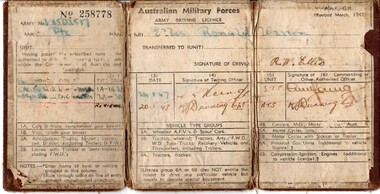 Lara RSL Sub Branch
Drivers Licence, Australian Military Forces Army Driving Licence
Cpl. Ronald Warren Ellis, EM (VX502517) was born in Brunswick in 1927. His family moved to Lara when he was young, and his schooling took place at the Lara State School. After finishing his education, Ron took up employment at Sims Coopers in Corio. Ron was enlisted in the second AIF at Melbourne, and posted to the 3rd Recruit Training Battalion at Greta west of Newcastle, NSW. After 3 months training, he was sent to the Service Corps Training Centre for driver and maintenance training in Ingleburn, south of Sydney. When this course was completed, Ron was posted to the Australian Army Service Corps as a driver motor vehicle with the 2nd AIF. Rons service with the AIF lasted 425 days, when he was then transferred to the Interim Army for a further 309 days. The duration of his service was in NSW. Ron was discharged from the Army in Melbourne on the 4th of May 1948. In 1957, Ron enlisted in the CMF and served with 22nd Construction Squadron for 17 years with the last 5 as a Corporal, and was awarded the Efficiency Medal for long service and good conduct.Brown canvas booklet that is folded into three. Licence gives details of Army number, name, rank and type of vehicle that is able to be driven. Licence has been issued to Private Ronald Warren Ellis on 24/01/1948. No. 258778 Army No. V?SOL517 Rank: Private Name in full: Ellis, Ronald Warren Unit: Transferred to (unit): Having passed the prescribed tests ... authorised to drive... types of ... vehicles within the Commonwealth of Australia and Territories. Signature of Driver: drivers licence, australian military forces, army, private, ellis, ww2, wwii, world war two, second world war -
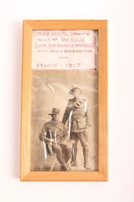 Lara RSL Sub Branch
Photo, Harry Grove
This photo is from 1917 and is of Private Harry Groves (standing) with his cousin Arthur Whitter (seated). Private Groves was the Uncle of Ron Ellis, who was a Lara Sub-Branch member. Cpl. Ronald Warren Ellis, EM (VX502517) was born in Brunswick in 1927. His family moved to Lara when he was young, and his schooling took place at the Lara State School. After finishing his education, Ron took up employment at Sims Coopers in Corio. Ron was enlisted in the second AIF at Melbourne, and posted to the 3rd Recruit Training Battalion at Greta west of Newcastle, NSW. After 3 months training, he was sent to the Service Corps Training Centre for driver and maintenance training in Ingleburn, south of Sydney. When this course was completed, Ron was posted to the Australian Army Service Corps as a driver motor vehicle with the 2nd AIF. Rons service with the AIF lasted 425 days, when he was then transferred to the Interim Army for a further 309 days. The duration of his service was in NSW. Ron was discharged from the Army in Melbourne on the 4th of May 1948. In 1957, Ron enlisted in the CMF and served with 22nd Construction Squadron for 17 years with the last 5 as a Corporal, and was awarded the Efficiency Medal for long service and good conduct. This photo represents the connection that Lara RSL members and their family members have to the conflicts that Australia has been involved in over time. Photograph of Harry Grove (standing) with his cousin Arthur Witter (seated) - France 1917. The black and white photo is framed within a wooden frame, and above it is a piece of paper with details about the photo written in red texta. The photo is black and white, and in the bottom right corner in pencil is written: Sincerely Yours, Arthur. The remainder of the text extends under the frame, but looks as though it says: Arthur, France. world war 1, ww1, wwi, photo, family, private, corporal -
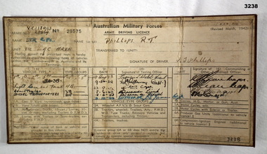 Bendigo Military Museum
Administrative record - DRIVERS LICENCE WW2, Australian Military Forces, c.1942
Item re R T PHILLIPS VX113093, refer Cat No 3239P for his service details.Australian Army Driving Licence for Cpl R T PHILLIPS VX113093. Folds three ways. Left column shows vehicle types that PHILLIPS was authorised to drive. Column three shows authorised dates 10 Aug 1942 - 14 Oct 1943. Column six shows signature of CO. Brown buckram exterior."Licence No 29575"documents - licences/military, drivers