Showing 54 items
matching victoria reef plan
-
 Bendigo Historical Society Inc.
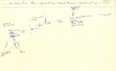
Document - NEW CHUM LINE OF REEF - PLAN OF MINES ALONG PART OF THE NEW CHUM LINE OF REEF
Sketch of some mines along the New Chum Line of Reef. Sheet No (178) Caleb Thomas 1879 Jan 29th. Mines mentioned are: Prince Alfred, Victoria Consols, G Lansell's No 83. Some mines are only a number. Victoria Reef Gold Mines are mentioned. Distances in feet or yards between them.document, gold, new chum line of reef, plan of mines along part of the new chum line of reef, caleb thomas, prince alfred mine, victoria consols, g lansell's no 83, ironbark, victoria reef gold mines -
 Bendigo Historical Society Inc.
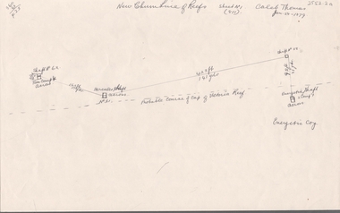
Document - NEW CHUM LINE OF REEF - PART OF A PLAN OF MINES ALONG THE NEW CHUM LINE OF REEF
Sketch of mines along the New Chum Line of Reef Sheet No 1 (811) Caleb Thomas Jun 28, 1879. Mines mentioned are the Hercules and the Energetic. The others are shaft numbers. Measurements between each in feet and yards. Probable course of cap of Victoria Reef drawn in.document, gold, new chum line of reef, part of a plan of mines along the new chum line of reef, caleb thomas, hercules mine, energetic mine, energetic coy -
 Bendigo Historical Society Inc.
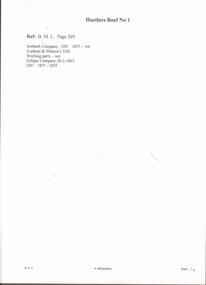
Document - HUSTLERS REEF - PLANS & SECTIONS TO ACCOMPANY BULLETIN NO 33
Pink page pasted onto cream card titled Plans and Sections to accompany Bulletin No 33. Hustler's Line of Reef, Bendigo by H S Whitelaw, by Authority: Albert J. Mullett, Government Printer, Melbourne. Plate No 1 to No 34. Mines mentioned: Fortuna Hustler's Mine, Hustler's Royal Reserve No 2 Mine, Hustler's Royal Reserve Mine Park Shaft, Great Extended Hustler's Mine, Hustler's Reef and Hustler's Reef No 1 Mines, Hustler's Reef Mine, Comet Mine, United Hustler's and Redan Mine, K. K. Mine, Hustler's Consols Mine, Fortuna Hustler's Mine. Department of Mines Geological Survey of Victoria 1914. Written on the back: Lightning Hill area to Summer Hill.document, hustlers reef, plans & sections to accompany bulletin no 33, geological survey of victoria, department of mines, hustler's line of reef, h s whitelaw, fortuna hustler's mine, hustler's royal reserve no 2 mine, hustler's royal reserve mine park shaft, great extended hustler's mine, hustler's reef mine, hustler's reef no 1 mine, comet mine, united hustler's mine, redan mine, k k mine, hustler's consols mine, fortuna hustler's mine, hustler's consols mine, albert j mullett, government printer melbourne -
 Bendigo Historical Society Inc.
Map - GREAT EXTENDED HUSTLER'S MINE - TRANSVERSE SECTION OF THE GREAT EXTENDED HUSTLER'S MINE
Transverse Section of the Great Extended Hustler's Mine on the Hustler's Line of Reef. Bulletin No 33, Plate No XII. Shows Poppet legs at the surface and Sill of Shaft at 788.99 feet above Sea Level, Cross Cuts and their depths, stone and geographical features encountered and their references and a number of enlarged drawing of sections of the crosscuts, Geological Survey of Victoria emblem and signed by H A Whitelaw, Underground Survey Office Bendigo, September 1913. The depths of crosscuts to No 21 were taken from plans of surveys by Mr. Walker and Mr. Craven, noted under Reference. Another note: This Saddle Reef is sketched from Mr. Walker's plan. Dividends amounting to 360,000 pounds were obtained from it. mining, parish map, great extended hustler's mine, transverse section of the great extended hustler's mine, old shaft, mr walker, mr craven, geological survey of victoria, underground survey office bendigo, h a whitelaw -
 Bendigo Historical Society Inc.
Map - GREAT EXTENDED HUSTLER'S MINE - PLAN OF THE GREAT EXTENDED HUSTLER'S MINE
Plan of the Great Extended Hustler's Mine on the Hustler's Line of Reefs, Bendigo. Bulletin No 33, Plate No X. Lease No 7382. Plan has map of streets. Mine was located in the block bounded by Langston and Anderson Streets and was between the Hustler's Anticline at Surface and the Lightning Hill Anticline at Surface. Latham & Watson's Shaft is also mentioned. Levels are numbered and a table shows the Levels and their Depths. Geological Survey of Victoria. Signed by H A Whitelaw, Underground Survey Office, Bendigo, September 1913. This item has not been scanned or photographed.mining, parish map, great extended hustler's mine, hustler's line of reefs, mining lease no 7382, geological survey of victoria, underground survey office bendigo, h a whitelaw, latham & watson's shaft -
 Bendigo Historical Society Inc.
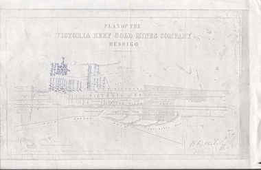
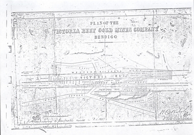
Document - VICTORIA HILL - PLAN OF THE VICTORIA REEF GOLD MINES COMPANY
... VICTORIA HILL - PLAN OF THE VICTORIA REEF GOLD MINES... Plan of the Victoria Reef Gold Mines Company...Plan of the Victoria Reef Gold Mines Company, Bendigo...DOCUMENT Gold Victoria Hill Plan of the Victoria Reef Gold ...Plan of the Victoria Reef Gold Mines Company, Bendigo showing the Eastern Victoria Reef, Victoria Reef and the Western Victoria Reef. Streets, gullies and leases drawn in. Some amounts of money and names have been written on the page. Signed by H. B. Nicholas. Locations of Ballerstedt's, Luffsman's, Wittscheibe's, Midway Co and Rae's engines are shown. Ironbark, Derwent, Providence and Long Gullies are shown. Also Mount Korong Road. Leases mentioned are: Jackson, Burrows, Wybarndt, Ballerstedt, Luffsman, Roberts, Ashley, Grant, Troy, Tezeau, Woodward, Croath, Taylor, Cranshaw, Gou?d & Co, Midway, Wittscheibe, Specimen Hill Co, Endeavour, Albert Co, Ballerstedt & Son, Hy? Co, and Wheadon.document, gold, victoria hill, plan of the victoria reef gold mines company, h b nicholas, spiers, jackson, burrows, wybarndt, ballerstedt, luffsman, roberts, ashley, grant, troy, tezeau, woodward, croath, taylor, cranshaw, gou?d & co, midway, wittscheibe, specimen hill co, endeavour, albert co, ballerstedt & son, hy? co, and wheadon -
 Bendigo Historical Society Inc.
Document - Geological Survey of Victoria, Hustlers Line of Reef, Bendigo, April, 2014
Seven men were killed at the Great Extended Hustler's mine disaster on 2nd May 1914 by an explosion of dynamite occurring as the men were waiting at the plat to ascend the mine at the end of their shift. No blame was attached to anyone in the findings of the inquisition. It was unknown what caused the dynamite to explode. This document formed part of the research done at the time by Bendigo Historical Society, of the 100 years commemoration of the mine disaster, held at Hustler's Hill in 2014. Seven page photocopy of Department of Mines, Bulletin, Geological Survey of Victoria, Hustlers Line of Reef, Bendigo, No. 33 by H.S. Whitelaw. Includes plan of Hustlers Royal Reserve No. 2, (main shaft) showing location on Pall Mall, and location of Post Office and Law Courts; plan of location of Hustlers Royal Reserve No. 2 (Park Shaft) showing Jail (sic), Camp Hill State School, two 'lagoons' in between tennis court, croquet court and bowling green; a plan of the Great Extended Hustler's Shaft and two copied images of Hustler's Hill showing mining buildings, poppet heads and chimneys. Comet, K.K., Hustler's No. 1, Old Comet and United Hustler's and Redan Mines are shown in the images. great extended hustlers, goldmining, accident, quartz, mining, k.k. mine, comet mine, hustler's line of reef, old comet, united hustler's, redan -
 Bendigo Historical Society Inc.
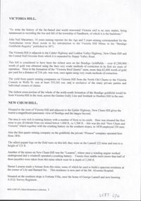
Document - VICTORIA HILL - VICTORIA HILL AND NEW CHUM HILL
Typed notes on Victoria Hill and New Chum Hill. Notes give location, value of gold and plans for a mining museum.document, gold, victoria hill, victoria hill and new chum hill, john neil macartney, the age, the australasian, bendigo goldfields registry 1871, victoria reef quartz mine, north old chum, victoria consols, new chum and victoria, pioneer, lansell 222 mine, lazarus, barnet lazarus, mt. alvernia hospital, fortuna villa, george lansell, a. h. q. survey regiment, central red white and blue, hudsons, burrowes & sterry, b c v channel 8, bendigo and district tourist association, section 14 of the lands act 1958, mr a r richardson, cr t r flood, tourist association -
 Bendigo Historical Society Inc.
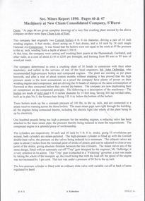
Document - VICTORIA HILL - PLAN OF THE VICTORIA REEF GOLD MINES COMPANY BENDIGO
... VICTORIA HILL - PLAN OF THE VICTORIA REEF GOLD MINES... Plan of the Victoria Reef Gold Mines Company Bendigo...MAP Bendigo Victoria Hill Plan of the Victoria Reef Gold ...3587.70 same as 3587.69. Copied onto smaller white paper.map, bendigo, victoria hill, plan of the victoria reef gold mines company bendigo -
 Bendigo Historical Society Inc.
Document - NEW CHUM & VICTORIA LINES OF REEF - NEW CHUM CONSOLIDATED COMPANY, S'HURST
Handwritten notes from Se? Mines Report Pages 46 & 47 on the Machinery at New Chum Consolidated Company, Sandhurst. Notes include boilers, Compressors, Battery and mentions plans. There are also descriptions of the machinery. A typed copy is also included.document, gold, new chum & victoria lines of reef, new chum & victoria lines of reef, new chum consolidated company s'hurst, shenandoah, garibaldi, mr john delbridge, pearl company -
 Bendigo Historical Society Inc.
Map - MINING PLAN ,VICTORIA HILL AREA, No date visible
Map: Large scale plan of an area of the Goldfield, Northward from Barnard Street, covering the Victoria Hill area. Black printing on polycarbonate film. Transparent.map, bendigo, mining plan, mining, gold mines, victoria hill, lines of reef -
 Bendigo Historical Society Inc.
Map - HUSTLER'S REEF & HUSTLER'S REEF NO 1 MINES - PLAN OF THE HUSTLER'S REEF & HUSTLER'S REEF NO 1 MINES
... Survey of Victoria Plan of the Hustler's Reef & Hustler's Reef ...Plan of the Hustler's Reef & Hustler's Reef No 1 Mines on the Hustler's Line of Reefs, Bendigo Bulletin No 33, Plate No XIV. No 8 connecting No 10 (Hustler's Reef), No 11 connecting No 13 (Hustler's Reef), No 13 (Hustler's Reef No 1) connecting No 15 (Hustler's Reef) and No 10 Hustler's Reef No 1 rise to Comet Mine. Map shows different levels in relation to the two shafts, the lines of the Hustler's Line of Reefs and the Lightning Hill Line of Reefs, the approximate Boundary of Lease and the Comet Co., the adjoining lease. Table on the left shows the levels and their depths of the two mines. Signed by H A Whitelaw, Underground Survey Office, Bendigo, September 1913. Geological Survey of Victoria emblem. mining, parish map, hustler's reef & hustler's reef no 1 mines, hustler's line of reefs lightning hill line of reefs, comet co., h a whitelaw, underground survey office bendigo, geological survey of victoria -
 Bendigo Historical Society Inc.
Map - HUSTLER'S REEF & HUSTLER'S REEF NO 1 MINES - PLAN OF THE HUSTLER'S REEF & HUSTLER'S REEF NO 1 MINES
Plan of the Hustler's Reef & Hustler's Reef No 1 Mines on the Hustler's Line of Reefs Bulletin No 33, Plate No XVII. Two drawings with different levels on each for clarity. Shows depth and some geographical features. Geological Survey of Victoria emblem. Signed by H A Whitelaw Underground Survey Office Bendigo, September 1913. mining, parish map, hustler's reef & hustler's reef no 1 mines, hustler's line of reefs, geological survey of victoria, underground survey office bendigo, h a whitelaw -
 Bendigo Historical Society Inc.
Map - HUSTLER'S REEF & HUSTLER'S REEF NO 1 MINES - PLAN OF THE HUSTLER'S REEF & HUSTLER'S REEF NO 1 MINES
Plan of the Hustler's Reef & Hustler's Reef No 1 Mines on the Hustler's Line of Reefs Bulletin No 33, Plate No XV. Plan shows the two mines with depth of levels, geological features and levels in relation to the shaft. Geological Survey of Victoria emblem and signed by H A Whitelaw, Underground Survey Office Bendigo, September 1913. Note - The Lease Boundaries shown on this plan are only in their approximate relative positions to Nos 13, Intermediate and 14 Levels of the Hustler's Reef No 1 workings, and Nos 15, 16 and 17 Levels of the Hustler's Reef workings.mining, parish map, hustler's reef & hustler's reef no 1 mines, geological survey of victoria, underground survey office bendigo, h a whitelaw, hustler's line of reefs -
 Bendigo Historical Society Inc.
Map - HUSTLER'S REEF & HUSTLER'S REEF NO 1 MINES - PLAN OF THE HUSTLER'S REEF & HUSTLER'S REEF NO 1 MINES
... Office Bendigo Geographical Survey of Victoria Plan ...Plan of the Hustler's Reef & Hustler's Reef No 1 Mines on the Hustler's Line of Reefs, Bendigo Bulletin No 33, Plate No XVI. Plan shows the two shafts and the levels in relation to it. No 9 Level 896 feet 9 inches connecting No 10 Level at 867 feet 2 inches. Plan shows depth of levels and geographical features. Signed by H A Whitelaw, Underground Survey Office, Bendigo. Geographical Survey of Victoria emblem.mining, parish map, hustler's reef & hustler's reef no 1 mines, hustler's line of reefs, h a whitelaw, underground survey office bendigo, geographical survey of victoria -
 Bendigo Historical Society Inc.
Map - FORTUNA HUSTLER'S MINE - PLAN OF FORTUNA HUSTLER'S MINE
Map and plan of the Fortuna Hustler's Mine on the Hustler's Line of Reefs. Bulletin No 33, Plate No 1. Plan gives depth of the different levels. Bendigo Railway Station is on the map and also a number of the streets. Carpenter Street is called Cemetery Road. Also on the Hustler's Line of Reef is the Summer Hill Shaft. Shown is the Hustler's Royal Reserve No 2 Lease. Map has the Geological Survey of Victoria crest. It is signed by H Whit ? an Underground Survey Office Bendigo, September 1913. map, fortuna hustler's mine, hustler's royal reserve no 2 lease, summer hill shaft, hustler's line of reef -
 Bendigo Historical Society Inc.
Map - COMET MINE - LONGITUDINAL SECTION COMET MINE
Longitudinal section of the Comet Mine on the Hustler's Line of Reef Bulletin No 33, Plate No XXVI signed by H. S. Whitelaw, Underground Survey Office Bendigo, September 1913. Map shows datum lines, depths of levels, approximate boundaries and references to other plans. Note - Plates 4, 8, 13, 20, 26 and 31 form a Longitudinal Section from Fortuna Hustler's to Hustler's Consols Mine. Geological Survey of Victoriamining, parish map, hustler's line of reef, longitudinal section of comet mine bulletin no 33 plate no xxvi, h s whitelaw -
 Bendigo Historical Society Inc.
Map - COMET MINE - PLAN OF COMET MINE
Plan of the Comet Mine on the Hustler's Line of Reefs Bulletin No 33, Plate No XXIII. Map shows depths, Lightning Hill Anticline, Hustler's Anticline and approximate Lease Boundary. Signed by H. S. Whitelaw, Underground Survey Office Bendigo, September 1913. United Hustler's & Redan Co and Hustler's Reef Co also named on map. Geological Survey of Victoriamining, hustler's line of reefs, comet line plan belletin no 33 plate no xxiii, lightning hill anticline, hustler's anticline, united hustler's & redan co, hustler's reef co, h s whitelaw -
 Bendigo Historical Society Inc.
Map - COMET MINE - PLAN OF COMET MINE
Plan of the Comet Mine on the Hustler's Line of Reefs Bulletin No 33, Plate No XXIV signed by H S Whitelaw, Underground Survey Office Bendigo, September 1913. Upper and Lower Levels and approximate boundaries shown. Depths shown.Geological Survey of Victoriamining, parish map, hustler's line of reefs, comet mine plan bulletin no 33 plate no xxiv -
 Bendigo Historical Society Inc.
Map - HUSTLER'S ROYAL RESERVE NO 2 MINE - PLAN OF THE HUSTLER'S ROYAL RESERVE NO 2 MINE
Plan of the Hustler's Royal Reserve No 2 Mine Bulletin No 33, Plate No V. Plan shows the Hustler's Royal Reserve No 2 (Main Shaft), Hustler's Royal Reserve No 2 (Park Shaft.), the Royal Hustler's, the Imperial Hustler's and the Extended Hustler's Freehold on the Hustler's Line of Reefs. Also mentioned is the Lightning Hill Line of Reefs. Map shows some of the levels, approximate boundary of lease and the boundary of Lease No 8892 and 8897. There are also street names and the locations of jail, lagoons, Post Office, Rosalind Park and the State School, High School and Continuation School. Geological Survey of Victoria emblem. H. Herman Director, W. Dickson, Secretary of Mines and The Hon. J. Drysdale Brown MLC, Minister of Mines. Signed by zh Whitdan, Underground Survey Office, Bendigo, September 1913.mining, parish map, hustler's royal reserve no 2 mine, royal hustler's, imperial hustler's, extended hustler's freehold, geological survey of victoria, h herman, w dickson, the hon j drysdale brown, h whitdan, hustler's line of reefs, lightning hill line of reefs -
 Bendigo Historical Society Inc.
Map - HUSTLER'S ROYAL RESERVE NO 2 MINE - PLAN OF THE HUSTLER'S ROYAL RESERVE NO 2 MINE
Plan of the Hustler's Royal Reserve No 2 Mine on the Hustler's Line of Reefs Bulletin No 33, Plate No VI. Boundary of Leases No 8898 and 8897 shown. Various levels shown and some geographical features. Geological Survey of Victoria emblem. H . Harman, Director, W. Dickson, Secretary for Mines and The Hon. J. Drysdale Brown, Minister of Mines and signed by H Whitdon, Underground Survey Office, Bendigo, September 1913. mining, parish map, hustler's royal reserve no 2 mine, hustler's line of reefs, geological survey of victoria, h herman, w dickson, the hon j drysdale brown mlc -
 Bendigo Historical Society Inc.
Map - UNITED HUSTLER'S & REDAN & K. K. MINES - PLAN OF THE UNITED HUSTLER'S & REDAN & K. K. MINES
Plan of the United Hustler's & Redan & K. K. Mines Bulletin No 33 Plate No XXXI. Shows depth of levels, Probable positions of reefs and natural surface with the poppet legs at the two shafts. Sill of shaft of the K. K. Mine 773.56 ft above Sea Level and sill of shaft of the United Hustler's & Redan Mine 745.62 above Sea Level. Also mentioned is the average amount of gold obtained per ton. Note on the top of page - Plates 4, 8, 13, 20, 26 & 31 form a Longitudinal Section from Fortuna Hustler's to Hustler's Consols Mine. Geological Survey of Victoria emblem and signed by H S Whitelaw, Underground Survey Office, Bendigo, September 1913. mining, parish map, united hustler's & redan & k. k. mines, geological survey of victoria, h s whitelaw, underground survey office bendigo -
 Bendigo Historical Society Inc.
Map - UNITED HUSTLER'S & REDAN & K. K. MINES - PLAN OF UNITED HUSTLER'S & REDAN & K. K. MINES
Plan of the United Hustler's & Redan & K. K. Mines on the Hustler's Line of Reefs Bulletin No 33 Plate No XXVII. Plan shows depth of levels, Long Gully, Hustler's Line of Reefs, Lightning Hill Line of Reefs and approximate Boundary of Lease. Also mentions Comet Co. Geological Survey of Victoria emblem and signed by H S Whitelaw, Underground Survey Office Bendigo September 1913.mining, parish map, united hustler's & redan & k. k. mines, long gully, hustler's line of reefs, lightning hill line of reefs, comet co, h s whitelaw, geological survey of victoria, underground survey office -
 Bendigo Historical Society Inc.
Map - UNITED HUSTLER'S & REDAN & K. K. MINES - PLAN OF UNITED HUSTLER'S & REDAN & K. K. MINES
Plan of the United Hustler's & Redan & K. K. Mines on the Hustler's Line of Reefs Bulletin No 33 Plate No XXVIII. Plan shows depth of levels, stone encountered and some geological features. Geological Survey of Victoria emblem and signed by H S Whitelaw, Underground Survey Office Bendigo, September 1913. mining, parish map, united hustler's & redan & k. k. mines, united hustler's and redan shaft, k. k. shaft, h s whitelaw