Showing 244 items
matching warrandyte vic
-
 Ringwood and District Historical Society
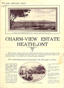
Flyer, Land Sale Brochure, Charm-View Estate, Heathmont, Vic. - c1926
Double sided folded page advertisement highlighting local facilities, services and layout of blocks for sale in Charm-View Estate.Subdivision includes Heathmont Road, Orchid Street, Bennett Avenue, Dickasons Road and Canterbury Road. (Agents) T. Burkitt & Co., Phone Ringwood 157, Overton & Co., 390 Chapel Street South Yarra, Phone Windsor 542. Solicitor A.V. Wischer, 443 Chancery Lane, Melbourne. -
 Ringwood and District Historical Society
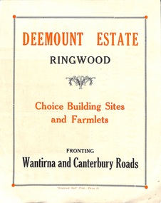
Flyer, Subdivisional Land Sale advertisement - Deemount Estate, Ringwood, Vic. - c.1950
Double sided folded page with black and orange advertisement and blueprint for Deemount Estate fronting Canterbury and Wantirna Roads, Ringwood, with handwritten price list and terms of sale.Subdivision includes Canterbury Road, Wantirna Road and Maidstone Street. -
 Ringwood and District Historical Society
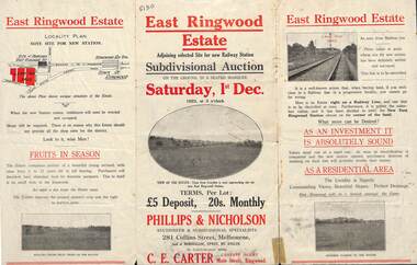
Flyer, Subdivisional Auction Sale Brochure, East Ringwood Estate, Vic. - 1923
Tri-folded double sided advertisement for subdivisional auction sale on Saturday, 1st December, 1923, including location map and summary of local facilities and services.Subdivision includes Patterson Street, Bona Street, Miller Grove, Fairview Avenue and Eastfield Road. Auctioneer - Phillips & Nicholson, 281 Collins Street, Melbourne. Tel. Central 10907. Agent - C.E. Carter, Main Street, Ringwood. Tel. Ringwood 24. -
 Ringwood and District Historical Society
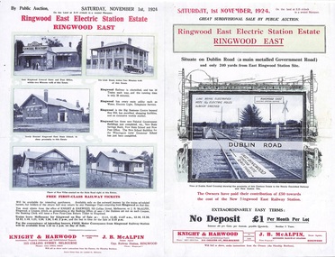
Flyer, Land Sale Auction Brochure, Electric Station Estate, Ringwood East, Vic. - 1924
Folded double-sided advertisement for Ringwood East Electric Station Estate subdivisional sale of retail and residential allotments by public auction on Saturday, 1 November, 1924, with local photographs, terms of sale, and summary of subdivision features and local facilities. Subdivision includes Railway Parade (later Patterson Street, Rosedale Crescent, Federal Road, Howship Avenue (later Howship Court and French Street), and Dublin Road. (Agents) Knight & Harwood, 315 Collins Street, Melbourne, Phone Central 10615, 10616, in conjunction with J.B. McAlpin, Opposite Railway Station, Ringwood, Phone Ringwood 7. -
 Ringwood and District Historical Society
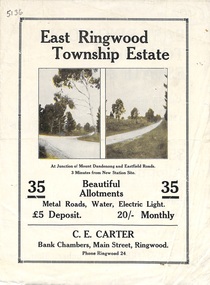
Flyer, Subdivisional Land Sale Brochure, East Ringwood Township Estate, Vic. - 1923
Bi-folded double sided land subdivision sale advertisement with location map and summary of local facilities and services. Includes two additional images of allotment plan with subsequent handwritten notations.Subdivision includes Mount Dandenong Road, Grey Street, and Eastfield Road. Agent - C.E. Carter, Bank Chambers, Main Street, Ringwood. Phone Ringwood 24. -
 Ringwood and District Historical Society
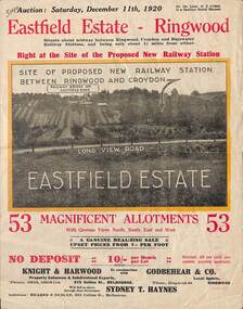
Flyer, Subdivisional Land Auction Sale Brochure, Eastfield Estate, Ringwood, Vic. - 1920
Bi-folded double sided land advertisement for subdivision auction on Saturday, December 11th, 1920, for Eastfield Estate with location map and summary of local facilities and services.Subdivision includes Croydon South streets - Eastfield Road, Long View Road, The Mount, and Pleasant Rise. Local Agent - Godbehear & Co, Phone Ringwood 49. -
 Ringwood and District Historical Society
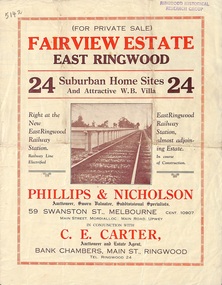
Flyer, Land Sale Brochure, Fairview Estate, East Ringwood, Vic. - circa 1925
Bi-folded single sheet advertisement for private sale of residential allotments, including subdivision features and local facilitiesSudivision includes Eastfield Road, Margaret Street and Patterson Street. Local Agent - C.E. Carter, Bank Chambers, Main St., Ringwood. Tel. Ringwood 24. -
 Ringwood and District Historical Society
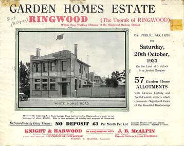
Flyer, Subdivisional Land Auction Sale Brochure, Garden Homes Estate, Ringwood, Vic. - 1923
Double sided multi-folded page advertising auction sale of residential allotments highlighting local facilities, services and layout of the estate. Includes panoramic view of Ringwood and other local photographic images.Subdivision includes Mullum Mullum Road, The Centreway, Wattle Crescent and Reserve Crescent. Agents - Knight & Harwood, 315 Collins Street, Melbourne, Phone 10615, 10616 Central, in conjunction with J.B. McAlpin, Opposite Railway Station, Ringwood. Phone Ringwood 7. -
 Ringwood and District Historical Society
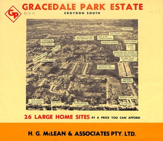
Flyer, Land Sale Brochure, Gracedale Park Estate, Croydon South, Vic. circa 1968
Although the brochure advertises Gracedale Park Estate as Croydon South, the home sites and streets are in the 3135 postcode area, i.e. Ringwood East/Heathmont.Bi-folded orange coloured sheet with black print advertising sale of residential allotments, including subdivision features and local facilities.Sudivision includes Ringwood East streets - Gracedale Avenue and Raymond Court. Agent - H.G. McLean & Associates Pty. Ltd., 166 Canterbury Road, Heathmont. Telephone 870 3422, A/Hours 870 5879, 729 2809. -
 Ringwood and District Historical Society
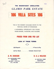
Flyer, Land Sale Brochure, Glamis Park Estate (Wantirna, Vic.) - 1959
Street name Carnarvon Avenue on the subdivision plan became Selkirk Avenue at some stage during or subsequent to development of the Estate.Bi-folded advertisement for sale of residential allotments, including summary of subdivision features and local facilities.Subdivision includes Wantirna streets - Wantirna Road, Carnarvon Avenue, Inchcape Avenue, St Thomas Avenue, St Davids Drive, Dudley Avenue, Angus Avenue. Agents - A.W. Dickson, 136 Whitehorse Road, Ringwood, Telephone WU 6007, WU 7016, A.H. WU 6868. D. & J. Walker, 18 Junction Street, Ringwood, Telephone WU 6516 (all hours). -
 Ringwood and District Historical Society
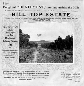
Pamphlet, Atlas Press Pty. Ltd., Melbourne, Land Sale Brochure, Hill Top Estate, Heathmont, Vic. - circa 1925
Twelve page land sale brochure promoting Heathmont and Ringwood area including photographs, subdivision features and local facilities. Subdivision plan includes Heathmont Road, Balfour Avenue, Edith Street, Edna Street, and Great Ryrie Street. -
 Ringwood and District Historical Society
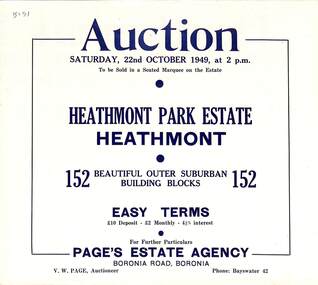
Flyer, Land Auction Sale Brochure, Heathmont Park Estate, Heathmont, Vic. - 1949
Double sided multi-fold advertisement for auction sale of residential allotments, including summary of subdivision features and local facilities. Auction on Saturday, 22nd October, 1949, at 2 p.m.Subdivision includes Great Ryrie Street, Erica Crescent, Neil Street, Frances Street, Viviani Crescent, and Canterbury Road. Agent - Page's Estate Agency, Boronia Road, Boronia. Phone Bayswater 42. -
 Ringwood and District Historical Society
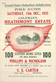
Flyer, Land Sale Brochure, Coleman's Heathmont Estate, Ringwood, Vic. - 1923
Bi-fold advertisement for auction sale of residential sites, including photographs, map, and summary of subdivision features and local facilities. Auction date Saturday 15th December, 1923. Subsequent auction date Saturday 19th January, 1924, following previous sale stopped on account of rain. Initial newspaper advertisement (publication unknown) dated 16/11/23.Subdivision includes Bedford Road, Canterbury Road, Alvena Crescent, Leonard Street (later Royal Avenue), and Coleman Street. Agent - Phillips & Nicholson, 281 Collins Street Melbourne, (Phone) Central 10907, in conjunction with C.E. Carter, Main Street, Ringwood. Tel. Ringwood 24. -
 Ringwood and District Historical Society
Flyer, Land Sale Brochure, Heathmont Estate, Vic. - circa 1960
Advertisement for sale of residential lots - Heathmont Estate, opposite Heathmont Railway Station, with map and locality plan.Subdivision includes Canterbury Road, Royal Avenue, Coleman Street, Stoda Street, Herman Street, and Campbell Street. Agent - A.W. Dickson, opposite Station, Ringwood. Phone WU6007. -
 Ringwood and District Historical Society
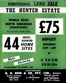
Flyer, Land Sale Brochure, The Hunter Estate, North Ringwood, Vic. - circa 1960
Bi-fold land sale advertisement for The Hunter Estate, North Ringwood, including terms of sale, area map, layout of the estate, and summary of local facilities and services, with separate attachment listing lot number prices.Subdivision includes Wonga Road, Hunter Avenue (later Graeme Avenue), Panfield Avenue, Hendra Grove, and Mullum Mullum Road. Agent - N.R. Reid & Co. Pty. Ltd., Station Entrance, Ringwood. (Phone) WU 6661. -
 Ringwood and District Historical Society
Flyer, Executor's Auction Subdivision Advertisement, Lilydale Road and Oban Road, Ringwood East, Vic. - 1937
Single page advertisement for Executor's Auction of land in Ringwood East on Saturday, May 29, 1937 with locality map showing 26 building sites for auction highlighted in brown, and brief summary of local services available. Subdivision includes Old Lilydale Road, Joseph Street, Dynes Street, Albert Street (later Wyrunga Street), Carcoola Road, and Mount Dandeong Road. (Carcoola Road incorrectly shown as Oban Road on the subdivision plan). Auctioneer - C.E. Carter, (Phone Ringwood 24. -
 Ringwood and District Historical Society
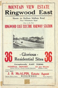
Flyer, Land Sale Brochure, Mountain View Estate, Ringwood East, Vic. - 1923
Bi-fold advertisement for sale of residential allotments, including photographs, map, and summary of subdivision features and local facilities. Undated handwritten notation reads "streets don't exist today".Subdivision layout includes Mullum Mullum Road, Rangeview Avenue, Press Avenue, and Mountview Avenue. Local Agent - J.B. McAlpin, Opposite Railway Station, Ringwood, Phone Ringwood 7. Vendor - T.J. Press, Builder, "Monterey", Second Avenue, Kew, Telephone Haw. 3428. -
 Ringwood and District Historical Society
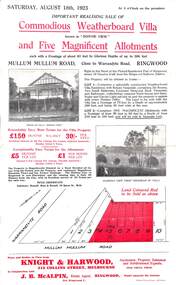
Flyer, Advertisement for Mullum Mullum Road, Ringwood, Vic., Sale of "Bonnie View" Villa and five allotments. - 1923
Single page flyer advertising realising sale of villa and land in Mullum Mullum Road, Ringwood, at 3 o'clock on Saturday, August 18th, 1923. Also includes descriptions and photographs of the property, location of the blocks, and summary of local train services.Auctioneer - Knight & Harwood, 315 Collins Street, Melbourne, Tel 10615, 10616, in conjunction with local agent - J.B. McAlpin, Opposite Railway Station, Ringwood, Tel. Ringwood 7. -
 Ringwood and District Historical Society
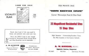
Flyer, Land Sale Brochure, North Ringwood Estate, Ringwood, Vic. - 1958
Double-sided land sale advertisement for sale of 35 residential and 15 shop sites on the corner of Warrandyte Road and Oban Road, Ringwood North, Vic., including locality plan and features of the estate.Subdivision includes Oban Road, Warrandyte Road, and Dickson Crescent. Agent: A.W. Dickson, Opposite Station, Ringwood. (Phone) WU6007, WU7016, after hours WU6868. -
 Ringwood and District Historical Society
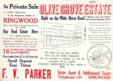
Flyer, Land Sale Advertisement, Olive Grove Estate, Ringwood, Vic. - 1926
Further development of 9 shop sites took place along Whitehorse Road (later street numbers 58 to 64 Whitehorse Road) between New Street and Olive Grove around 1950 - See Victorian Collections reference 5227.Single sided page with red and blue print advertising Olive Grove Estate business and residential allotments, including subdivision plan and summary of local services.Subdivision includes Whitehorse Road, New Street, and Olive Grove. Agent - F.V. Parker, Telephone 131, Ringwood. -
 Ringwood and District Historical Society
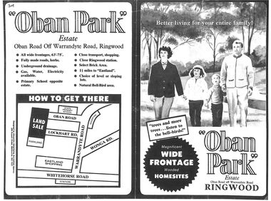
Flyer, Land Sale Advertisement, Oban Park Estate, Ringwood, Vic. - 1969
One double-sided and two single-sided pages advertising Oban Park Estate land sale, including terms of sale, locality map, subdivision features and summary of local services.Subdivision includes Oban Road, Terrigal Close, Dorelaw Drive (later Melview Drive), Naroo Court, Barook Court, and Lockhart Road. Agents in Conjunction: E. Wachman, Melbourne, Hutchinson Real Estate, Ashwood, and A.W. Dickson, 136 Whitehorse Road, Ringwood (Phone) 870-6007 A.H. 882967. Separate newspaper advertisement (digital only) shows agents - Hutchison Real Estate (Telephone 277-2326) and Michelson Gelfand Pty Ltd (Telephone 53-8151). -
 Ringwood and District Historical Society
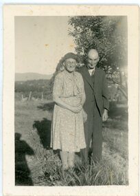
Photograph, Norman Leslie (Les) Lade & wife Ethel, Ringwood Vic. - circa 1950's
Black and white photo showing Norman Lade & wife Ethel posing outdoors."On back of photo" Norman Leslie (Les) Lade of Ringwood & Ethel Lade, his wife. -
 Ringwood and District Historical Society
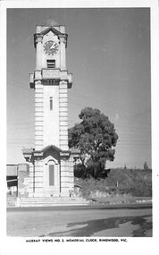
Photograph/Postcard, Postcard - Murray Views No.2 - Ringwood Main St and Clocktower in original position
Black and white "Murray Views" postcard - Ringwood memorial clock tower, cnr Maroondah Highway & Warrandyte Road, looking south towards railway line.Front: "Murray Views No. 2 Memorial Clock, Ringwood, Vic." Back: "1948" handwritten. "Real Photograph Produced in Australia by Murray Views, Gympie, Q." -
 Eltham District Historical Society Inc
Photograph - Aerial Photograph, Landata, Research, Vic, Apr. 1972
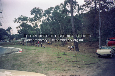
... (Vic.) Research-Warrandyte Road Reynolds Road Swiper's Gully ...Centred on present day Main Road, Research near Maroondah Aqueduct and Eltham College bounded by Allendale Road to north, Research-Warrandyte Road to south, Swipers Gully Training Restaurant to east and Reynolds Road to west. Historic Aerial Imagery Source: Landata.vic.gov.au Aerial Photo Details: Project No :985 Project : MELBOURNE 1972 Run : 26 Frame : 194 Date : 04/1972 Film Type : B/W Camera : RC10 Flying Height : 5700 Scale : 9600 Film Number : 2636 GDA2020 : 37°42'07"S, 145°11'07"E MGA2020 : 340015, 5825692 (55) Melways : 22 H1 (ed. 42)aerial photo, neil webster collection, 1972-04, allendale road, eltham college, main road, maroondah aqueduct, melway 22h1, research (vic.), research-warrandyte road, reynolds road, swiper's gully -
 Eltham District Historical Society Inc
Photograph, Fay Bridge, Book launch of Laughing Waters Road by Jane Woollard at Montsalvat, Eltham, 30 January 2016
Laughing Waters Road , the book was launched at Montsalvat in Eltham. On Saturday, January 30, 2016, Nillumbik Council launched this book. The weather was cool; just as well, considering over 500 people attended this very pleasant event where food and drink were plentiful. The Australian Government and Nillumbik Shire Council funded the book and it was designed by Wayne Rankin of North Warrandyte. The dedication page is to our very own Ranger Campbell Beardsell OAM of Parks Vic who taught Jane to be “passionate about the environment of this special place” (p260). FOWSP members Val Polley, Linda Rogan and Ken Crook contributed to the content and photos. David Wandin, Wurundjeri Elder, gave a Welcome to Country and officially launched the book after the Mayor of Nillumbik, Cr Hattam, made introductions. Jane Woollard followed with a brief outline of how she came to write the book (her very first) and read out loud the last paragraph which focuses on reconciliation and shared culture. Jane declared in her preface that the book “has been formed by attending to the connection between rivulets of memories, creeks of hearsay, rivers of tales, the meanders of local legend and the deep, still pools of the archive.” Very poetic! - Lynda Gilbert Newsletter; Friends of Warrandyte State Park March 2016, Volume 34 Number 2 Laughing Waters Road , the book was launched at Montsalvat in Eltham ON SATURDAY 30 JANUARY Nillumbik Council launched this book. The weather was cool; just as well, considering over 500 people attended this very pleasant event where food and drink were plentiful. The Australian Government and Nillumbik Shire Council funded the book and it was designed by Wayne Rankin of North Warrandyte. The dedication page is to our very own Ranger Campbell Beardsell OAM of Parks Vic who taught Jane to be “passionate about the environment of this special place” (p260). FOWSP members Val Polley, Linda Rogan and Ken Crook contributed to the content and photos. David Wandin, Wurundjeri Elder, gave a Welcome to Country and officially launched the book after the Mayor of Nillumbik, Cr Hattam, made introductions. Jane Woollard followed with a brief outline of how she came to write the book (her very first) and read out loud the last paragraph which focuses on reconciliation and shared culture. Jane declared in her preface that the book “has been formed by attending to the connection between rivulets of memories, creeks of hearsay, rivers of tales, the meanders of local legend and the deep, still pools of the archive.” Very poetic! - Lynda Gilbert Newsletter; Friends of Warrandyte State Park March 2016, Volume 34 Number 2 https://fowsp.org.au/docs/News_2016/34_02_March.pdffay bridge collection, 2016-01-30, book launch, bronnie hattam, jane woollard, laughing waters road, montsalvat, sigmund jorgensen, harry gilham, maurice hurry -
 Eltham District Historical Society Inc
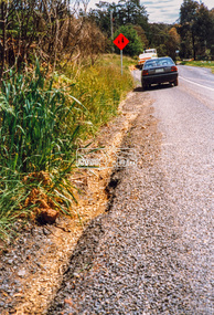
Photograph - Colour Print, Eltham Shire Council, Roadside verge issue, unidentified road, Eltham diistrict, c.1990, c.1990
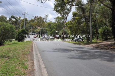
... (Vic Reg) Infrastructure Research (Vic.) Research-Warrandyte ...Possibly Research-Warrandyte Road near Researchell731 (vic reg), infrastructure, research (vic.), research-warrandyte road, roads, shire of eltham -
 Eltham District Historical Society Inc
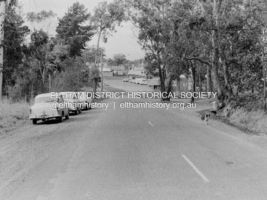
Photograph, Barry Philp, Eltham-Yarra Glen Road, Research, Vic, c.1967
... intersection with Research-Warrandyte Road and Research shops, c.1967 ...View looking north along Eltham-Yarra Glen Road towards intersection with Research-Warrandyte Road and Research shops, c.1967. Three cars on the left, two FC Holden sedans (1958-1960) and a Holden HD Station Sedan (1965-1966)In digital metadata "My beautiful picture"cars, eltham-yarra glen road, holden fc, holden hd, main road, research (vic.), research shops, research-warrandyte road -
 Eltham District Historical Society Inc
Photograph, Barry Philp, Eltham-Yarra Glen Road, Research, Vic, c.2013
... intersection with Research-Warrandyte Road and Research shops, c.2013 ...View looking north along Eltham-Yarra Glen Road towards intersection with Research-Warrandyte Road and Research shops, c.2013eltham-yarra glen road, main road, research (vic.), research shops, research-warrandyte road -
 Eltham District Historical Society Inc
Photograph (Item) - Negative, Jocelyn Zepter-Trevor, Main Road at Research-Warrandyte Road, Research, 1988
... - 35mm negative Series 35 Main Road Research (Vic.) Research ...Jocelyn Zepter-Trevor 1988 Entrant No. 69 Ref: Series 34, Item 24 The images in this record were not selected for inclusion. SHIRE OF ELTHAM COMMUNITY PHOTOGRAPHIC SURVEY Photography is an artform which many of us practice, sometimes purely for artistic pursuit, sometimes to record the people and events in our lives. In 1988, as part of a local Bicentennial project, the Shire of Eltham conducted the Eltham Community Photographic Survey. Up to 100 entries were to be selected by a panel of photographers for entry into the Eltham Photographic Survey Exhibition. Entries had to be submitted by May 13, 1988. Entrants whose images were selected for the exhibition were contacted and requested to further submit an entry form providing entrant’s name, area of residence, age, and proposed captions. These details were then used to produce labels for the exhibition mounts. Where negatives had not been supplied, these were requested to support the display of printed enlargements mounted on 10” x 8” cardboard. The mounted prints were made available post exhibition for sale at $8.50 each for colour prints and $7.00 for B&W prints. Residents in the Shire were invited to collect a free roll of film and take a photograph of what they either liked or did not like about the area. A total of 160 entrants submitted multiple entries for the exhibition. Of those selected for exhibition, entrants ranged in age from 9 to 70 years. All custom colour and black and white printing for the exhibition was completed by Wattle Studios of Eltham. The Eltham Photographic Survey was jointly auspiced by the Shire of Eltham and Wattle Studios, of 953 Main Road, Eltham. The project was greatly assisted by: • David McRitchie, Media Studies Lecturer Victoria College, Rusden Campus. • Ian and Annette Toohill of Wattle Studios • Tracy Naughton, Eltham Community Arts Officer • Neville Emerson Pty. Ltd. • Superior Press, Eltham • Kodak Australasia Pty. Ltd. • Agfa Gevaert Ltd. • Townsend Colourtech Pty. Ltd. • The Australian Bicentennial Authority • Eleanor Bowers, Secretary, Eltham Arts Council The exhibition was placed on display in the Woolworths Arcade, Eltham between Monday June 6th and Saturday June 11, 1988. It was also intended to hold the exhibition at a venue in the Shire’s North Riding from Monday, June 20 to Friday June 24. It was then displayed at the Were Street Theatre, Montmorency from Friday, June 24 to Thursday, July 7. Series 34: Eltham Community Photographic Survey 1988 - Prints & Documentation Series consists of 117 photographs of Shire scenes taken by members of the community. Items I - 41 are larger photographs mounted on card, which were exhibited. Items 42 - 117 are unmounted copies, alternative takes and other entries. Corresponding negatives contained in Series 35: Eltham Community Photographic Survey 1988 – Negatives which consists of 267 colour and B&W negatives and one colour slide of Shire scenes taken by members of the community. The negatives are arranged by the entrant number of the photographer. The Eltham Community Photographic Survey collection is significant to the local community as it was curated by the local community - ordinary people of all ages - representing what they liked and did not like in the area where they lived. It represents an unfiltered representation of the Shire of Eltham as it was in 1988. It also represents one of many projects as part of the national programme of events and celebrations to commemorate the bicentenary. It is a time capsule of life in the 1980s of this urban and rural municipality in Melbourne's north. shire of eltham archives, bicentennial project, eltham community photographic survey, film - agfa xr 100 i, jocelyn zepter-trevor, scan - 35mm negative, series 35, main road, research (vic.), research-warrandyte road -
 Eltham District Historical Society Inc
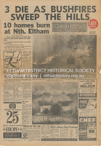
Newspaper - Newspaper articles, The Herald, 3 Die as Bushfires Sweep the Hill: 10 homes burn at Nth. Eltham, The Herald, Wednesday, March 3, p1, 1965
Various news articles pertaining to the January 1965 Victorian bushfires specifically with a focus on fires at Eltham North. Specific Eltham Shire districts mentioned include Eltham North and veteran Herald staff photographer Bert Rodda on page 1 • 3 Die as Bushfires Sweep the Hill: 10 homes burn at Nth. Eltham, p1 (Illust.) • 100 dogs die, p1 • Taken on the run, p1 (Illust.) • Fire runs wild at Eltham, p3 (Illust.) • 10-mile front out of control; Gippsland area ablaze, p3 • Trapped, but saved by wind, p3 tom fielding collection, victorian bushfires - 1965, victorian bushfires – 1965, eltham north, bert rodda, glen park road, short road, research (vic.), wattle glen, diamond creek, warrandyte, eltham, gippsland, mrs g. maher, bill dancy, eltham north store, bushfire damage - buildings