Showing 46 items
matching water canals
-
 St Kilda Historical Society
Photograph - Photo map, 11/01/1968
One of a series of photo-maps produced for the Department of Crown Lands and Survey (1857-1983). For correlation with a current map, and access to other historical photo maps of Victoria, see the Historic Photo-Maps Index published by the Department of Environment, Land, Water and Planning at https://services.land.vic.gov.au/DELWPmaps/historical-photomaps/Black and white aerial photographVic 2132 State Aerial Survey Melbourne 1968 Proj. Run 29E 11.1.68 5100 ASL 196elwood, elwood park, elwood canal, elwood beach, st kilda marina, mc moran reserve, point ormond, 1968 -
 St Kilda Historical Society
Photograph - Photo map, 14/12/1963
One of a series of photo-maps produced for the Department of Crown Lands and Survey (1857-1983). For correlation with a current map, and access to other historical photo maps of Victoria, see the Historic Photo-Maps Index published by the Department of Environment, Land, Water and Planning at https://services.land.vic.gov.au/DELWPmaps/historical-photomaps/Black and white aerial photographVic 1807 Melbourne 1963 Project Run 17 14.12.63 Lens 205 152.70 M/M 5.150 36st kilda, st kilda botanical gardens, balaclava, st kilda east, elwood canal, ripponlea, caulfield north, elwood, caulfield, 1963 -
 St Kilda Historical Society
Photograph - Photo map, Department of Crown Lands and Survey (1857-1983), 22/01/1970
One of a series of photo-maps produced for the Department of Crown Lands and Survey (1857-1983). For correlation with a current map, and access to other historical photo maps of Victoria, see the Historic Photo-Maps Index published by the Department of Environment, Land, Water and Planning at https://services.land.vic.gov.au/DELWPmaps/historical-photomaps/Black and white aerial photographVic 2358 Department of Crown Lands and Survey Victoria,.© Melbourne 1970 Project Run 42E 22.1.70 5,100 ASL 77st kilda, st kilda east, st kilda marina, elwood, elwood canal, elsternwick park, point ormond, balaclava, mc moran reserve, ripponlea, st kilda botanical gardens, peanut farm, 1970 -
 St Kilda Historical Society
Photograph - Photo map, Department of Crown Lands and Survey, 22/01/1970
One of a series of photo-maps produced for the Department of Crown Lands and Survey (1857-1983). For correlation with a current map, and access to other historical photo maps of Victoria, see the Historic Photo-Maps Index published by the Department of Environment, Land, Water and Planning at https://services.land.vic.gov.au/DELWPmaps/historical-photomaps/Black and white aerial photographVic 2358 Department of Crown Lands and Survey Victoria,.© Melbourne 1970 Project Run 43E 22.1.70 5,100 ASL 208elwood, elwood beach, point ormond, elwood park, elwood canal, mc moran reserve, 1970 -
 Tatura Irrigation & Wartime Camps Museum
Photograph, Goulburn Irrigation System, 1970s
Taken by photographer for State Rivers and Water Supply Commission.Medium sized black and white photograph. Map showing the Goulburn Irrigation System in Northern Victoria including Eildon Reservoir, Waranga Reservoir, Eppalock Reservoir, Eppalock, Cairn Curran, Laancoorie, Tullaroop Reservoirs, the Stuart Murray, Cattanach Canal, East Goulburn Main and Waranga Western Channels.goulburn weir, victorian state rivers and supply commission -
Tatura Irrigation & Wartime Camps Museum
Photograph, 1953
Taken by photographer for State Rivers and Water Supply Commission.Medium sized black and white photograph. Foreground - Theodolite / Two men / Rock Crusher / Tractor pulling To construct earth fill bank at cattanach canalgoulburn weir, victorian state rivers and supply commission -
Tatura Irrigation & Wartime Camps Museum
Photograph, 1954
Taken by photographer for State Rivers and Water Supply Commission.Medium sized black and white photograph. Workmen laying rock beaching material on the earth fill bank of the cattanach canalgoulburn weir, victorian state rivers and supply commission -
Tatura Irrigation & Wartime Camps Museum
Photograph, Cattanach Canal, 1957
... rivers and water supply commission Cattanach Canal Below photo ...Taken by the photographer for Victoria State Rivers and Water Supply Commission.Large black and white photograph. Water in lowest level of canal, three levels of embankment shown on either side, rock fill left foregroundBelow photo: "Cattanach Canal"irrigation, victoria state rivers and water supply commission, cattanach canal -
Tatura Irrigation & Wartime Camps Museum
Photograph, Cattanach Canal, 1957
... rivers and water supply commission cattanach canal Above photo ...Taken by the photographer for Victoria State Rivers and Water Supply Commission.Large sepia photograph - water filled channel inlet and bank - Man standing on platform looking down on concrete wall of measuring weir.Above photo: "Cattanach Canal / Inlet and Measuring Weir to Waranga Basin."irrigation, victoria state rivers and water supply commission, cattanach canal -
Tatura Irrigation & Wartime Camps Museum
Photograph, Cattanach Canal, 1957
... rivers and water supply commission cattanach canal Waranga Basin ...Taken by the photographer for Victoria State Rivers and Water Supply Commission.Large sepia photograph - large stretch of water in foreground, men leaning down from platform above measuring weir in middle of photograph - trees on bank left and middle distance.Above photo: "Cattanach Canal / Inlet and Measuring Weir to Waranga Basin."irrigation, victoria state rivers and water supply commission, cattanach canal, waranga basin, measuring weir -
Tatura Irrigation & Wartime Camps Museum
Photograph, Cattanach Canal, 1957
... rivers and water supply commission cattanach canal Above photo ...Taken by the photographer for Victoria State Rivers and Water Supply Commission.Large sepia photograph - Concrete structure, side wings, three centre supports, platform and framework above. Man standing, looking up from base. Cracked earth floor and embankment.Above photo: "Cattanach Canal / Regulator on Connection to No.1 Main Channel"irrigation, victoria state rivers and water supply commission, cattanach canal -
Tatura Irrigation & Wartime Camps Museum
Photograph, Cattanach Canal, 1957
... rivers and water supply commission cattanach canal Bridges Below ...Taken by the photographer for Victoria State Rivers and Water Supply Commission.Large sepia photograph - Construction equipment middle foreground, two bridges, truck crossing second bridge, trees, flat paddock, scattered trees, man working on nearer concrete bridge support.Below photo: "Cattanach Canal / Rail and Highway Bridges near Murchison"irrigation, victoria state rivers and water supply commission, cattanach canal, bridges -
Tatura Irrigation & Wartime Camps Museum
Letter - Camp 13 History, Cattanach Canal History Residents of Camp 13 Murchison During Period 1952 - 1956
3 Typed pages stapled at top left corner, type colour is purple. Also a handwritten post script on last page. non-fiction -
 Kew Historical Society Inc
Postcard, R McGeehan, The Effect of Storm. Train Passing Through Flood Waters, South Yarra, 25-1-07, 1907
SHARP DOWNPOUR. ONE INCH IN 45 MINUTES. SOUTHERN SUBURBS DELUGED. TRAIN STOPPED AT SOUTH YARRA. One of the sudden downpours of rain which occasionally fall in Melbourne occurred yesterday afternoon, when nearly an inch of rain fell in the course of three quarters of an hour, and caused a flood for an hour or two in certain localities. During the early part of the day, the sky had been clouded over, but there was nothing to indicate a storm of such intensity as that which followed. At about half-past 1 o'clock residents of South Yarra, South Melbourne, Prahran, and St. Kilda noticed a few drops of rain. Still, it appeared unlikely that there would be anything exceptional, until with startling suddenness at about 10 minutes to 1 o'clock, one of the heaviest downpours within the memory of residents burst upon those suburbs. A strange feature of the storm was that it was practically confined to an area of about three miles square. The city was but little affected, though at a spot as close as the Observatory 86 points of rain were recorded in three-quarters of an hour. Thunder and lightning accompanied the downpour, which was cyclonic in character, the rain driving heavily from all points of the compass as the cyclone passed. It was in South Yarra and Prahran that the rain fell heaviest. Within a few minutes after it commenced, the low-lying portions of Toorak-road and practically the whole length of Chapel-street were under water. The depression at the intersection of Toorak-road and Darling-street speedily filled to the dimensions of a small lake. Several shops were inundated, while the water from the higher levels rushed down like a mountain torrent, and in several in-stances swept through the rear of houses and shops, carrying furniture in a floating mass against the further walls. In one case a footbridge was carried bodily away and dashed to pieces. Darling-street itself Great Davis-street, and other low-lying and flat thoroughfares in the vicinity became flooded from kerb to kerb, while on the other side of the railway-bridge the valley between Kensington-road and River-street became filled for some minutes to a depth of several feet. Meanwhile the waters from South Yarra hill, seeking a lower level, found it in the railway cutting, and the excavations from South Yarra station to Prahran on the one line, and to the Chapel-street bridge on the other, were converted into a couple of canals. At the platforms at South Yarra the water was two feet deep on the permanent way, and towards Hawksburn, at the sudden depression under Chapel-street bridge, it was at one time deep enough to cover a tall man's head. Into this swirling mass of water the 1:50 p.m. train from Oakleigh plunged on its way to Melbourne. The impact caused a mighty fountain of water to rise to a height of about 20 feet above the level of Chapel-street and send clouds of spray in all directions. Under the belief that a terrible explosion had occurred residents braved the rain and rushed to the spot, only to find that the train had been brought to a stand-still in the middle of what seemed to be a river. The water was so high that it had entered the fire-box from below, extinguishing the fires and cutting off the steam supply. In the meantime the officials at the South Yarra station had been preparing for emergencies. Inspectors were on duty at intervals along the line, and the moment the alarm was given an extra engine was backed carefully down and continued on to connect with the stranded train without losing its own power. There was a delay of about ten minutes in the service for an hour or two, but by 5 o'clock all the trains were running on time again, and the water had run off all but the spot beneath the Chapel-street bridge. Here the water remained about four feet deep until nightfall, and throughout the afternoon several hundreds of people including biograph operators and photographers, were gathered around watching each train pass through. Even with the water two feet lower, this was a work attended with considerable difficulty. Each train had to absolutely force its way through the weight of water, almost enveloped by the spray thrown up, and it was only just able to negotiate the "ford" by using every ounce of steam. ... The Argus, 26 January 1907, p19.The item forms part of the Laurie Bennett collection of thirty-six postcards and photographs of Kew and early Melbourne, donated to the Kew Historical Society in 1980. The postcards in the Bennett collection, like other images in the Society's holdings date from the 1890s to the present and comprehensively indicate points-of-view or scenes considered historically, aesthetically or socially significant in the period in which they were produced.Postcard depicting a flood at South Yarra Station in 1907. The title and photographer's name are identified on the front of the postcard. Donated by L. Bennett, 1980flood - south yarra, trains - melbourne, postcards, r mcgeehan - prahran -
 Magnet Galleries Melbourne Inc
soldiers resting / in camp, red cliffs00143.tif
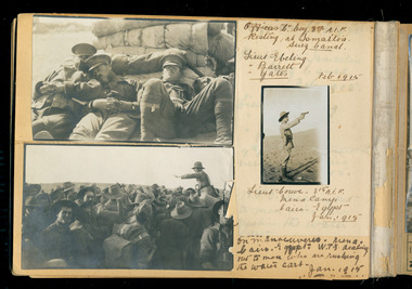
Officers of the 8th Australian Imperial Force. Officers resting, while on manoeuvres, among them William T. Yates of Camperdown. Yates survived Gallipoli, went to France where he won a Distinguished Conduct Medal at Bullecourt and survived a bullet wound to the head in 1917. In 1919 he went to America to study agriculture prior to becoming a soldier settler in the Sunraysia region. The rush for water the heat of the desert among parched troops on manoeuvres. "Officers 'C' Coy (company) 8th A.I.F resting at Ismailia, Suez Canal" Lieut (Lieutenant) Ebeling, Barrett, Yates, Feb 1915 Lieut Couve 8th A.I.F, Mena Camp, Cairo Egypt Jan 1915 On manoeuvres, Mena, Cairo, Egypt. W.T.S dealing out to men who are rushing the water cart, Jan 1915 8th australian imperial force, officers, william t. yates, camperdown, desert, suez canal, ismailia, 8th a.i.f, australian infantry force, lieutenant, cairo, egypt, ww1, world war 1, soldiers, war -
 Eltham District Historical Society Inc
Film - Video (DVD), Melbourne and Metropolitan Board of Works, Yarra River Conference Proceedings; a Board of Works centenary event, 13-16 April 1991
Yarra River Conference History Segment [Noted on VHS tape jackets "Due to unavoidable circumstances, the quality of these tapes in some setions is less than desired."] The Yarra River Conference, organised by the Board of Works as part of the Centenary Celebrations, was held in the Board's Head Office Theatrette from 13-16 April, 1991. A segment of the Conference focussed on the role that the Yarra River has played in relation to the historical development of Melbourne. Conceived and presented by a group of prominent historians as a chronological 'trip down the river in time', and profusely illustrated with slides, this segment traced the various impacts that urban and rural growth, development of marine commerce, recreational uses, and environmental problems have had on the Yarra during a century and a half of European occupation. As no formal written paper of this combined presentation is available, these two video-tapes provide a record for anyone who has an interest in tis fascinating aspect of the Yarra's history. The speakers who combined to present this segment are identified on the cover of Tape 2. Tape 1 (2 hours) 1838-1863 Deputy ?? to Utility Early navigators of the Yarra River; developing the port of Melbourne; the gold rush and its effect on the new colony; punts and bridges; water supply; pollution of the Yarra; the discovery of gold and early settlement of the Yarra valley; floods of 1839 and 1863. 1863-1891 Formation of the Harbour Trust; Coode Canal; pollution of the Yarra by industry; aborigines, gold miners, timber getters in the Upper Yarra areas; bridges; the flood of 1891. Tape 2 ( 1 1/2 hours) 1892-1934: People Begin to See Beauty and Romance to the River Henley-on-Yarra; realignment of the Yarra; MMBW is responsible for a sewerage system; new docks to cope with increased overseas trade; development of recreational parks; new reservoirs; timber production and timber tramways; bushfire; flood of 1934. 1935-1970: The River is Neglected Still, Except When it Proves Useful Bushfirs of 1939; the end of many sawmills; birth of tourism; increased interest in conservation and preservation of land for open space; further augmentation of water supply system; birth of containerisation changes the port; environmental concerns gain momentum. Speakers Dr Tony Dingle *, Department of Economic History, Monash University Dr Carolyn Rasmussen *, History Consultant Prof. Graeme Davison, History Department, Monash University Mr. Tom Griffiths, Lecturer in Public History, Monash Uiversity Mr. Patrick Miller, History Consultant Mr. Colin Jones, Author and Historian * Co-authors of the Board's history, 'Vital Connections'.video recording, yarra river, conference proceedings