Showing 144 items
matching weatherboard school
-
 Kew Historical Society Inc
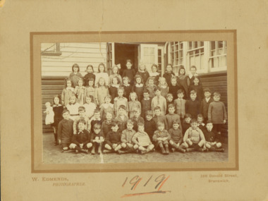
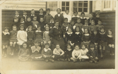
Photograph - Kew East State School, 1919
... a weatherboard ‘Rural’ school, a brick library, an administration block... a weatherboard ‘Rural’ school, a brick library, an administration block ...State School No. 3161 was originally situated between High Street (then Bulleen Road) and Kilby Road adjacent to Burke Road and was officially opened on 25th April 1892 with Mr Roland Gray as its Headmaster. With more people moving into the district, the School was moved in 1905 to Strathalbyn Street. (This site was to became the Kew East Bowling Club, and is now a Kindergarten.) 1929 saw the erection of the brick Infant School adjacent to the main building. In subsequent years many other buildings were added, including a weatherboard ‘Rural’ school, a brick library, an administration block, several portables, and a Community Music Centre and shelter sheds, culminating in the opening in March 2011 of the Commonwealth funded new Music/Sports Complex. At one time it was called Kew East Central School and included years 7 & 8. When Kew High School started, the high school students were accommodated there whilst their buildings were being completed.Original print positive, mounted on board of a co-educational class of students at Kew East 'Country School'. Margery Canham (nee Nickell) is identified in an inscription on the reverse of the mount. The Age newspaper on 6 March 1906 included in News of the Day that: "At a meeting of the Executive Council yesterday it was decided to proclaim the following State schools as training schools under the provisions of the Teachers' Act: Brunswick 1213; Queensberry-street, Carlton 2365; Kew East 3161; and Queensberry-street, North Melbourne 307. These schools have been specially selected and staffed in order that teachers in training and junior teachers may study the methods of the best teachers in special kinds of work. The infant class is the special feature at Brunswick, while Kew East will be a model of the methods of a country school. The schools at Queensberry-street, North Carlton and North Melbourne, are to be more especially connected with the training college."Obverse: Written on held chalk board: "Kew East 3161 / ? Grades / 1919". Reverse: "Margery Nickell, 4th row, back right"kew east primary school, margery canham, margery nickell, elizabeth angel, kew east state school, kew east country school -
 Kew Historical Society Inc
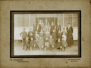
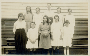
Photograph - Kew East Primary School, 1919
... a weatherboard ‘Rural’ school, a brick library, an administration block... a weatherboard ‘Rural’ school, a brick library, an administration block ...State School No. 3161 was originally situated between High Street (then Bulleen Road) and Kilby Road adjacent to Burke Road and was officially opened on 25th April 1892 with Mr Roland Gray as its Headmaster. With more people moving into the district, the School was moved in 1905 to Strathalbyn Street. (This site was to became the Kew East Bowling Club, and is now a Kindergarten.) 1929 saw the erection of the brick Infant School adjacent to the main building. In subsequent years many other buildings were added, including a weatherboard ‘Rural’ school, a brick library, an administration block, several portables, and a Community Music Centre and shelter sheds, culminating in the opening in March 2011 of the Commonwealth funded new Music/Sports Complex. At one time it was called Kew East Central School and included years 7 & 8. When Kew High School started, the high school students were accommodated there whilst their buildings were being completed.Original print positive, mounted on board of a co-educational class of students at Kew East 'Country School'. The Age newspaper on 6 March 1906 included in News of the Day that: "At a meeting of the Executive Council yesterday it was decided to proclaim the following State schools as training schools under the provisions of the Teachers' Act: Brunswick 1213; Queensberry-street, Carlton 2365; Kew East 3161; and Queensberry-street, North Melbourne 307. These schools have been specially selected and staffed in order that teachers in training and junior teachers may study the methods of the best teachers in special kinds of work. The infant class is the special feature at Brunswick, while Kew East will be a model of the methods of a country school. The schools at Queensberry-street, North Carlton and North Melbourne, are to be more especially connected with the training college."Obverse: Written on chalk slate - "Kew East / 3161 / Country School /19??"kew east primary school, margery canham, margery nickell, elizabeth angel, kew east state school, kew east country school, erik nickell -
 Kew Historical Society Inc
Photograph - Kew East State School
... a weatherboard ‘Rural’ school, a brick library, an administration block... a weatherboard ‘Rural’ school, a brick library, an administration block ...State School No. 3161 was originally situated between High Street (then Bulleen Road) and Kilby Road adjacent to Burke Road and was officially opened on 25th April 1892 with Mr Roland Gray as its Headmaster. With more people moving into the district, the School was moved in 1905 to Strathalbyn Street. (This site was to became the Kew East Bowling Club, and is now a Kindergarten.) 1929 saw the erection of the brick Infant School adjacent to the main building. In subsequent years many other buildings were added, including a weatherboard ‘Rural’ school, a brick library, an administration block, several portables, and a Community Music Centre and shelter sheds, culminating in the opening in March 2011 of the Commonwealth funded new Music/Sports Complex. At one time it was called Kew East Central School and included years 7 & 8. When Kew High School started, the high school students were accommodated there whilst their buildings were being completed.Original print positive of a co-educational class of students at Kew East State School. Howard Nickell is identified in an inscription on the reverse of the mount. The Age newspaper on 6 March 1906 included in News of the Day that: "At a meeting of the Executive Council yesterday it was decided to proclaim the following State schools as training schools under the provisions of the Teachers' Act: Brunswick 1213; Queensberry-street, Carlton 2365; Kew East 3161; and Queensberry-street, North Melbourne 307. These schools have been specially selected and staffed in order that teachers in training and junior teachers may study the methods of the best teachers in special kinds of work. The infant class is the special feature at Brunswick, while Kew East will be a model of the methods of a country school. The schools at Queensberry-street, North Carlton and North Melbourne, are to be more especially connected with the training college."Reverse: "Howard Nickell. Back Row. Second right."kew east primary school, elizabeth angel, kew east state school, howard nickell -
 Kew Historical Society Inc
Photograph - Kew East State School
... a weatherboard ‘Rural’ school, a brick library, an administration block... a weatherboard ‘Rural’ school, a brick library, an administration block ...State School No. 3161 was originally situated between High Street (then Bulleen Road) and Kilby Road adjacent to Burke Road and was officially opened on 25th April 1892 with Mr Roland Gray as its Headmaster. With more people moving into the district, the School was moved in 1905 to Strathalbyn Street. (This site was to became the Kew East Bowling Club, and is now a Kindergarten.) 1929 saw the erection of the brick Infant School adjacent to the main building. In subsequent years many other buildings were added, including a weatherboard ‘Rural’ school, a brick library, an administration block, several portables, and a Community Music Centre and shelter sheds, culminating in the opening in March 2011 of the Commonwealth funded new Music/Sports Complex. At one time it was called Kew East Central School and included years 7 & 8. When Kew High School started, the high school students were accommodated there whilst their buildings were being completed.Original print positive, mounted on board of a co-educational class of students at Kew East State School. Jean Nickell is identified in an inscription on the reverse of the mount. The Age newspaper on 6 March 1906 included in News of the Day that: "At a meeting of the Executive Council yesterday it was decided to proclaim the following State schools as training schools under the provisions of the Teachers' Act: Brunswick 1213; Queensberry-street, Carlton 2365; Kew East 3161; and Queensberry-street, North Melbourne 307. These schools have been specially selected and staffed in order that teachers in training and junior teachers may study the methods of the best teachers in special kinds of work. The infant class is the special feature at Brunswick, while Kew East will be a model of the methods of a country school. The schools at Queensberry-street, North Carlton and North Melbourne, are to be more especially connected with the training college."Obverse on chalkboard: "Kew East / 3161 / 1 & 2 Grades" / Reverse: "Jean Nickell. Back row 6th left"kew east primary school, elizabeth angel, kew east state school, jean nickell, w edmends -
 Kew Historical Society Inc
Photograph - Kew East State School, 1926
... a weatherboard ‘Rural’ school, a brick library, an administration block... a weatherboard ‘Rural’ school, a brick library, an administration block ...State School No. 3161 was originally situated between High Street (then Bulleen Road) and Kilby Road adjacent to Burke Road and was officially opened on 25th April 1892 with Mr Roland Gray as its Headmaster. With more people moving into the district, the School was moved in 1905 to Strathalbyn Street. (This site was to became the Kew East Bowling Club, and is now a Kindergarten.) 1929 saw the erection of the brick Infant School adjacent to the main building. In subsequent years many other buildings were added, including a weatherboard ‘Rural’ school, a brick library, an administration block, several portables, and a Community Music Centre and shelter sheds, culminating in the opening in March 2011 of the Commonwealth funded new Music/Sports Complex. At one time it was called Kew East Central School and included years 7 & 8. When Kew High School started, the high school students were accommodated there whilst their buildings were being completed.Original print positive of class of boys at Kew East State School. Hector Canham is identified in an inscription on the reverse of the mount. The Age newspaper on 6 March 1906 included in News of the Day that: "At a meeting of the Executive Council yesterday it was decided to proclaim the following State schools as training schools under the provisions of the Teachers' Act: Brunswick 1213; Queensberry-street, Carlton 2365; Kew East 3161; and Queensberry-street, North Melbourne 307. These schools have been specially selected and staffed in order that teachers in training and junior teachers may study the methods of the best teachers in special kinds of work. The infant class is the special feature at Brunswick, while Kew East will be a model of the methods of a country school. The schools at Queensberry-street, North Carlton and North Melbourne, are to be more especially connected with the training college."Obverse : "Hector [arrowed]" / Reverse: "5th Grade. Hector Canham. Back row left."kew east primary school, elizabeth angel, kew east state school, hector canham -
 Kew Historical Society Inc
Photograph - Kew East State School
... a weatherboard ‘Rural’ school, a brick library, an administration block... a weatherboard ‘Rural’ school, a brick library, an administration block ...State School No. 3161 was originally situated between High Street (then Bulleen Road) and Kilby Road adjacent to Burke Road and was officially opened on 25th April 1892 with Mr Roland Gray as its Headmaster. With more people moving into the district, the School was moved in 1905 to Strathalbyn Street. (This site was to became the Kew East Bowling Club, and is now a Kindergarten.) 1929 saw the erection of the brick Infant School adjacent to the main building. In subsequent years many other buildings were added, including a weatherboard ‘Rural’ school, a brick library, an administration block, several portables, and a Community Music Centre and shelter sheds, culminating in the opening in March 2011 of the Commonwealth funded new Music/Sports Complex. At one time it was called Kew East Central School and included years 7 & 8. When Kew High School started, the high school students were accommodated there whilst their buildings were being completed.Original print positive of a co-educational class at Kew East State School. Margaret Nickell is identified in an inscription on the reverse of the mount. The Age newspaper on 6 March 1906 included in News of the Day that: "At a meeting of the Executive Council yesterday it was decided to proclaim the following State schools as training schools under the provisions of the Teachers' Act: Brunswick 1213; Queensberry-street, Carlton 2365; Kew East 3161; and Queensberry-street, North Melbourne 307. These schools have been specially selected and staffed in order that teachers in training and junior teachers may study the methods of the best teachers in special kinds of work. The infant class is the special feature at Brunswick, while Kew East will be a model of the methods of a country school. The schools at Queensberry-street, North Carlton and North Melbourne, are to be more especially connected with the training college."Obverse : "Margery [arrowed]" / Reverse: "Margery Nickell. 2nd row left end. Teacher Miss Grey."kew east primary school, elizabeth angel, kew east state school, margery nickell -
 Kew Historical Society Inc
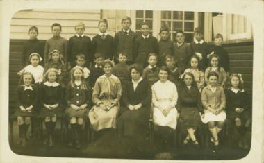
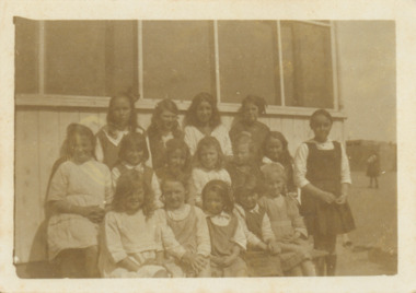
Photograph - Kew East State School, 1921-28
... a weatherboard ‘Rural’ school, a brick library, an administration block... a weatherboard ‘Rural’ school, a brick library, an administration block ...State School No. 3161 was originally situated between High Street (then Bulleen Road) and Kilby Road adjacent to Burke Road and was officially opened on 25th April 1892 with Mr Roland Gray as its Headmaster. With more people moving into the district, the School was moved in 1905 to Strathalbyn Street. (This site was to became the Kew East Bowling Club, and is now a Kindergarten.) 1929 saw the erection of the brick Infant School adjacent to the main building. In subsequent years many other buildings were added, including a weatherboard ‘Rural’ school, a brick library, an administration block, several portables, and a Community Music Centre and shelter sheds, culminating in the opening in March 2011 of the Commonwealth funded new Music/Sports Complex. At one time it was called Kew East Central School and included years 7 & 8. When Kew High School started, the high school students were accommodated there whilst their buildings were being completed.Original print positive of a class of girls at Kew East State School. The Age newspaper on 6 March 1906 included in News of the Day that: "At a meeting of the Executive Council yesterday it was decided to proclaim the following State schools as training schools under the provisions of the Teachers' Act: Brunswick 1213; Queensberry-street, Carlton 2365; Kew East 3161; and Queensberry-street, North Melbourne 307. These schools have been specially selected and staffed in order that teachers in training and junior teachers may study the methods of the best teachers in special kinds of work. The infant class is the special feature at Brunswick, while Kew East will be a model of the methods of a country school. The schools at Queensberry-street, North Carlton and North Melbourne, are to be more especially connected with the training college."Obverse : "East Kew 1921 [sic] / Reverse: "East Kew 1928 [sic]"kew east primary school, elizabeth angel, kew east state school -
 Kew Historical Society Inc
Photograph - Kew East State School
... a weatherboard ‘Rural’ school, a brick library, an administration block... a weatherboard ‘Rural’ school, a brick library, an administration block ...State School No. 3161 was originally situated between High Street (then Bulleen Road) and Kilby Road adjacent to Burke Road and was officially opened on 25th April 1892 with Mr Roland Gray as its Headmaster. With more people moving into the district, the School was moved in 1905 to Strathalbyn Street. (This site was to became the Kew East Bowling Club, and is now a Kindergarten.) 1929 saw the erection of the brick Infant School adjacent to the main building. In subsequent years many other buildings were added, including a weatherboard ‘Rural’ school, a brick library, an administration block, several portables, and a Community Music Centre and shelter sheds, culminating in the opening in March 2011 of the Commonwealth funded new Music/Sports Complex. At one time it was called Kew East Central School and included years 7 & 8. When Kew High School started, the high school students were accommodated there whilst their buildings were being completed.Original print positive of a class of girls at what is believed to be Kew East State School. The Age newspaper on 6 March 1906 included in News of the Day that: "At a meeting of the Executive Council yesterday it was decided to proclaim the following State schools as training schools under the provisions of the Teachers' Act: Brunswick 1213; Queensberry-street, Carlton 2365; Kew East 3161; and Queensberry-street, North Melbourne 307. These schools have been specially selected and staffed in order that teachers in training and junior teachers may study the methods of the best teachers in special kinds of work. The infant class is the special feature at Brunswick, while Kew East will be a model of the methods of a country school. The schools at Queensberry-street, North Carlton and North Melbourne, are to be more especially connected with the training college."Reverse : "Margery Nickell. 2nd row, 2nd left"kew east primary school, elizabeth angel, kew east state school, margery nickell -
 Kew Historical Society Inc
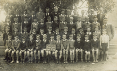
Photograph - Kew East Central School, c.1911
... a weatherboard ‘Rural’ school, a brick library, an administration block... a weatherboard ‘Rural’ school, a brick library, an administration block ...State School No. 3161 was originally situated between High Street (then Bulleen Road) and Kilby Road adjacent to Burke Road and was officially opened on 25th April 1892 with Mr Roland Gray as its Headmaster. With more people moving into the district, the School was moved in 1905 to Strathalbyn Street. (This site was to became the Kew East Bowling Club, and is now a Kindergarten.) 1929 saw the erection of the brick Infant School adjacent to the main building. In subsequent years many other buildings were added, including a weatherboard ‘Rural’ school, a brick library, an administration block, several portables, and a Community Music Centre and shelter sheds, culminating in the opening in March 2011 of the Commonwealth funded new Music/Sports Complex. At one time it was called Kew East Central School and included years 7 & 8. When Kew High School started, the high school students were accommodated there whilst their buildings were being completed.Original print positive of a class of boys at Kew East Central School. The Age newspaper on 6 March 1906 included in News of the Day that: "At a meeting of the Executive Council yesterday it was decided to proclaim the following State schools as training schools under the provisions of the Teachers' Act: Brunswick 1213; Queensberry-street, Carlton 2365; Kew East 3161; and Queensberry-street, North Melbourne 307. These schools have been specially selected and staffed in order that teachers in training and junior teachers may study the methods of the best teachers in special kinds of work. The infant class is the special feature at Brunswick, while Kew East will be a model of the methods of a country school. The schools at Queensberry-street, North Carlton and North Melbourne, are to be more especially connected with the training college."Obverse: on chalkboard - "East Kew Central School, Grade 5. 1911 [sic]". kew east primary school, elizabeth angel, kew east state school, kew east central school -
 Bendigo Historical Society Inc.
Photograph - COOK COLLECTION: SPRING GULLY SCHOOL STUDENTS 25/5/1920
... school weatherboard building. Male teacher standing on Right... standing/seated in five rows, outside school weatherboard building ...Photograph: black and white photo mounted on tan board. 52 school students standing/seated in five rows, outside school weatherboard building. Male teacher standing on Right Hand side, dressed in three piece suit, wing collar and tie. Students are dressed in various types of clothing, not uniform. Student centre front row is holding blackboard with '3505, Spring Gully, 25.5.20' written in white chalk. On back of photo is written in biro: Mrs. J. Noble, 232 Carpenter Street, Spring Gully, Bendigo Bottom Right Hand side of board : Photo, G.W. Bolton, Artist.G.W.Boltonphotograph, person, school children, spring gully, g.w. bolton, cook, noble, j. spring gully school. education -
 Bendigo Historical Society Inc.
Photograph - JOHN JONES COLLECTION: MANDURANG SCHOOL PHOTO 1922
... is standing on the left of the pupils. The school is weatherboard... on the left of the pupils. The school is weatherboard. Photo mounted ...Photograph of the Mandurang School pupils 1922 standing and sitting at the steps leading into the building. The teacher is standing on the left of the pupils. The school is weatherboard. Photo mounted on grey matt board. Some embossed lines around the photo. Photographer's name (G. V. Bolton Photo artist) imprinted on the bottom right corner. Written on the back in pencil - Mandurang School. In pen is 1922 and Mrs. J. Kerr per H Kofoed 6 Ewing Ave. Bendigo.G. V. Boltoneducation, bendigo, mandurang, john jones collection - mandurang school photo 1922, g v bolton, mrs j kerr, h kofoed -
 Bendigo Historical Society Inc.
Photograph - COOK COLLECTION: GROUP PORTRAIT, MEN, WOMEN AND CHILDREN
... rows, standing in front of weatherboard building (Spring Gully... rows, standing in front of weatherboard building (Spring Gully ...Photograph: black and white photo mounted on cream board. Group of men, women and children, standing and seated in four rows, standing in front of weatherboard building (Spring Gully School ? ). Five men are seated in front row, wearing three piece suits, ties. Women are dressed in long dresses, most wearing hats. Photo perhaps late 1800's ?. On bottom Left Hand side of photo written in black : Cyril white, Photo, Bendigo Written on back of photo in biro Mrs. J. Noble, 232 Carpenter Street, Spring Gully, BendigoCyril White, Bendigophoto, group, spring gully, family portrait, noble, j. -
 Eltham District Historical Society Inc
Photograph - Digital Photograph, Alan King, Panton Hill Primary School, 27 March 2008
... -shaped. Similar weatherboard State School buildings in the shire...-shaped. Similar weatherboard State School buildings in the shire ...The Panton Hill Primary School building, which has served the community since 1889, was not the area's first. Kingston School (an early name for Panton Hill) opened in May 1865. This was replaced in 1871 when the Panton Hill School number 1134 opened and in 1874 the school moved to its current location [September 2023] where many additions and renovations have taken place to meet the needs of local children in the 21st century. Covered under Heritage Overlay, Nillumbik Planning Scheme. Published: Nillumbik Now and Then / Marguerite Marshall 2008; photographs Alan King with Marguerite Marshall.; p63 The Panton Hill Primary School building, which has served the community since 1889, was not the area’s first. In 1871 Henry Edelman opened a Common School in a paling-clad hut, replacing the Kingstown No 786 school. The two-acre (0.8ha) site of crown land had previously been held under Miners Right. In 1875 the Education Department bought a building on the main road for State School No 1134, for £200 and remodelled it as a school.4 Panton Hill had as one of its teachers, Frank Tate, who was to become one of Victoria’s most influential educational reformers. It was his first school, when he began teaching on January 22, 1884, as a 20 year old.5 The following month Robert J Harris was appointed to the school and remained as head teacher until his death in 1887. His son R C Harris was apprenticed to Mr Rossiter, editor of the first local paper. The Evelyn Observer, first published in 1873. Harris later bought the newspaper which remained a family business until the 1920s. J Hughes of Cherry Tree Road succeeded Harris as teacher at Panton Hill and sold his land for the school site. Though now unrecognisable, the school building includes the classroom of the last Smiths Gully State School No 1737, which was built in 1882, and moved to Panton Hill in 1894. From 1922 each school day began with the ringing of the bell, which is still in its stand, and is an unusually old memorial of this kind. To accommodate the growing population, the building was remodelled, with additions in 1923 and classrooms were added in 1955, 1963 and 1970. The former teacher’s residence is the only surviving 19th century dwelling in the centre of Panton Hill, and is now used as part of the school. The residence was originally rectangular but is now L-shaped. Similar weatherboard State School buildings in the shire from this period are the Kangaroo Ground and the St Andrews Primary Schools. All were standard Education Department/Public Works Department designs.This collection of almost 130 photos about places and people within the Shire of Nillumbik, an urban and rural municipality in Melbourne's north, contributes to an understanding of the history of the Shire. Published in 2008 immediately prior to the Black Saturday bushfires of February 7, 2009, it documents sites that were impacted, and in some cases destroyed by the fires. It includes photographs taken especially for the publication, creating a unique time capsule representing the Shire in the early 21st century. It remains the most recent comprehenesive publication devoted to the Shire's history connecting local residents to the past. nillumbik now and then (marshall-king) collection, panton hill primary school -
 Phillip Island and District Historical Society Inc.
Photograph, Back to Phillip Island 1926, 1926
1926 was the centenary of the landing of the British forces and hoisting the flag at Rhyll in Dec 1826. The object of the " Back to" was a social reunion of former residents. HistoricalLarge black & white photo on brown cardboard of group of well dressed people, front row sitting, in front of weatherboard building, probably Cowes State School. List of names on rear. There is also an identical photo. Article from Trove explaining the background of the reunion.Names on rear provided by Bryant West. These vary slightly from names on rear of second photo provided by Mary Karney. back to phillip island 1926, photograph, forrest, west, morrison, cleeland, smith, henderson, bell, leeson, durrant, mcdonald -
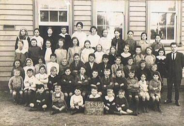
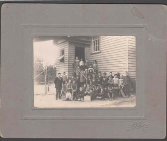
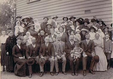
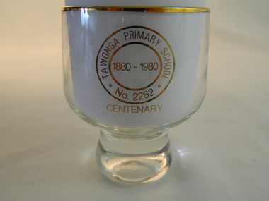 Kiewa Valley Historical Society
Trophies - Glass - Tawonga Primary School, 1980
... The Tawonga Primary School was a weatherboard building... The Tawonga Primary School was a weatherboard building built on 8 ...The Tawonga Primary School was a weatherboard building built on 8 acres. In 1900 a fire destroyed the building and its records. The school was then moved to the Old Tawonga Hall before a new one was built in 1910 on land donated by Frank Cooper. In 1937 and 1954 further buildings were added. Tobacco farming and the building of the Kiewa Hydro Electric Scheme increased the number of pupils during the 1950s and 1960s. This glass represents the celebration held when the school became 100 years old.Tawonga Primary School was established for the children of the farmers of the Kiewa Valley in 1880 and later for children of the tobacco farmers and workers on the Kiewa Hydro Electric Scheme. The history of the school reflects the activities of the people living in the valley and in particular Tawonga township.Clear glass with gold metal brim and embossed in gold on two sides. Base is solid tapering up to the glass sides.On one side: Gold embossed picture of school building On opposite side: Gold embossed 2 circles - Inside inner one: 1880 - 1980. Between this and outer circle - Tawonga Primary School No 2282. Underneath both circles gold embossed: Centenarytawonga primary school, kiewa valley, education -
 Kiewa Valley Historical Society
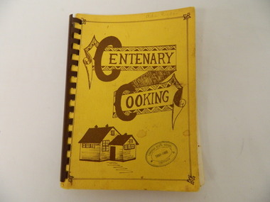
Book - Cooking x2, Centenary Cooking, 1980
... The Tawonga School was a weatherboard building built on 8... The Tawonga School was a weatherboard building built on 8 acres ...The Tawonga School was a weatherboard building built on 8 acres of land catering for children from the surrounding grazing farms to ride their horses to school. It opened on 27th July 1880. The original school building and records were erased by fire in 1900. The Tawonga hall was used until 1910 when 3 acres of land was donated by Frank Cooper. It still operates today (2015) with its numbers having fluctuated over the years with the Kiewa Hydro Electric Scheme, tobacco farming and now tourism. The Tawonga community published a cook book to celebrate the school's centenary.This book may have also been used as a fund raiser.The Tawonga school celebrated its centenary with a cookbook with contributions from the community. This indicates that the school was very proud of reaching its centenary and the community co-operated with each other to develop this book.This book is a good source of the names of people who lived in Tawonga in 1980.Yellow book with brown writing and sketch of school held together with brown hard plastic binding. It has 90 pages of recipes most of which give the contributor's name.Tawonga State School Centenary 1880 - 1980 (stamped on front & back cover) In pencil on front cover: Ada Ryder An advertising for Kelvinator sticker has been stuck on the inside front cover with 18-3-92 written on it & on the inside back cover and 'Energy Rating' sticker.tawonga school. centenary of school. 1880-1980. cooking. food. kiewa valley -
 Glen Eira Historical Society
Book - Dalkeith
A 69 page bound history of the McConchie family who occupied Dalkeith. Mention is also made of the Lade family who had associations with the McConchie family and Dalkeith. The book includes numerous stories and memories concerning places, residents and locals from areas where the McConchie and Lade families holidayed and lived. The book also includes copies of marriage certificates of the family, family photographs, birth certificates, newspaper articles relating to the McConchie family, relevant correspondence, a hand drawn plan of the Dalkeith property, school records and some other relevant extracts. The file also includes a one page hand drawn family tree and one page of handwritten research notes.mcconchie william, dick agnes, elsternwick, dalkeith, kooyong road, caulfield, davis street, bootmakers, staniland grove, saddleries, glenhuntly road, orrong road, carre street, charles street, hopetoun street, mcconchie harry, mcconchie alan, mcconchie don, grocers, caulfield citizen band, st johns presbyterian church, hawthorn road, caulfield methodist church, crocket mr, mcconchie janet, mcconchie agnes, mcconchie annie, lade family, lade ruth, lade marjorie, mcconchie thomas, blacksmiths, murray street, weatherboard buildings, st mary’s, glen eira road, bands, hopetoun gardens, elsternwick station, hansom cabs, tin lizzie vans, postal services, brighton cemetery, cemeteries, grange road, ripponlea, mcconchie david, caulfield state school -
 Eltham District Historical Society Inc
Photograph, Former Eltham Police Residence, 728 Main Road, Eltham, c.1985, 1985c
This photo is believed to have been taken circa 1985 when the Shire of Eltham Parks and Environment occupied the site. This photo was originally mounted on 3mm MDF fibre board with notes and stickers applied as part of a display on the former Police Residence and now present day Local History Centre, home to Eltham District Historical Society; possibly put together by Harry Gilham during his time as president of the society. Eltham Police Station and Residence: A brief history 1860 Eltham Courthouse built in Main Road, together with an adjoining police residence, office, lock–up and stables. 1959 Police Department purchases a house in Pryor Street to be refurbished as Eltham Police Station 1961 Police in Eltham move into Pryor Street refurbished buildings and office. c.1961-1981 Occupied by Vermin and Noxious Weeds Destruction Section of the Department of Crown Lands and Survey. Former Police Station dragged around to rear of Police Residence (prior to August 1967) to make way for the construction of a driveway and access from Main Road. The building was placed on the site of a former Scullery and modified for Lands Department use. 1981 Shire of Eltham take over management of old Police Residence in Eltham. It remains unoccupied for a period of time whilst its future is discussed in Council. 1981-1985 Used for community job creation scheme 1985 Shire of Eltham Parks and Environment occupy the residence. Council improve the driveway but later add a second rear access from Brougham Street due to the dangerous nature of the Main Road entrance. Also add a rear toilet facility between the Police Residence and former Police Station, which was doubling up as a lunch room. Council also commence discussions to re-establish a replica Police Station. c.1986 November. Former Police Station demolished; believed to have been suffering termite damage. c.1989 After some years of discussion a replica Police Station is built, based on photographs, to act as a lunch room and meeting room for Parks and Environment staff and volunteers doing community service. 1996 Eltham District Historical Society in discussions with Nillumbik Shire Council commisioners throughout the year regarding a home for the Society. A proposal put forward by the Society in October to occupy the former Police Residence. 1997 March. Eltham District Historical Society gains access to former Police Residence. 1998 July 12th. Eltham District Historical Society Inc moves into its Local History Centre, 728 Main Road Eltham (the former Police Residnce built in 1860). 2018 July. Eltham District Historical Society gains access to the replica Police Station for use as part of regular heritage tours for schools and community based groups.Colour printHandwritten in faded blue felt pen ink "No. 2 - Backyard of 728 #5 Weatherboard 'Office'. Note 1860 Court House over the fence."728 main road, eltham, local history centre, parks and environment, police residence, police station, shire of eltham -
 Eltham District Historical Society Inc
Photograph, Former Eltham Police Residence, 728 Main Road, Eltham, c.1985, 1985c
This photo is believed to have been taken circa 1985 when the Shire of Eltham Parks and Environment occupied the site. This photo was originally mounted on 3mm MDF fibre board with notes and stickers applied as part of a display on the former Police Residence and now present day Local History Centre, home to Eltham District Historical Society; possibly put together by Harry Gilham during his time as president of the society. Eltham Police Station and Residence: A brief history 1860 Eltham Courthouse built in Main Road, together with an adjoining police residence, office, lock–up and stables. 1959 Police Department purchases a house in Pryor Street to be refurbished as Eltham Police Station 1961 Police in Eltham move into Pryor Street refurbished buildings and office. c.1961-1981 Occupied by Vermin and Noxious Weeds Destruction Section of the Department of Crown Lands and Survey. Former Police Station dragged around to rear of Police Residence (prior to August 1967) to make way for the construction of a driveway and access from Main Road. The building was placed on the site of a former Scullery and modified for Lands Department use. 1981 Shire of Eltham take over management of old Police Residence in Eltham. It remains unoccupied for a period of time whilst its future is discussed in Council. 1981-1985 Used for community job creation scheme 1985 Shire of Eltham Parks and Environment occupy the residence. Council improve the driveway but later add a second rear access from Brougham Street due to the dangerous nature of the Main Road entrance. Also add a rear toilet facility between the Police Residence and former Police Station, which was doubling up as a lunch room. Council also commence discussions to re-establish a replica Police Station. c.1986 November. Former Police Station demolished; believed to have been suffering termite damage. c.1989 After some years of discussion a replica Police Station is built, based on photographs, to act as a lunch room and meeting room for Parks and Environment staff and volunteers doing community service. 1996 Eltham District Historical Society in discussions with Nillumbik Shire Council commisioners throughout the year regarding a home for the Society. A proposal put forward by the Society in October to occupy the former Police Residence. 1997 March. Eltham District Historical Society gains access to former Police Residence. 1998 July 12th. Eltham District Historical Society Inc moves into its Local History Centre, 728 Main Road Eltham (the former Police Residnce built in 1860). 2018 July. Eltham District Historical Society gains access to the replica Police Station for use as part of regular heritage tours for schools and community based groups.Colour printHandwritten in faded blue felt pen ink "Roof of room 5 (weatherboard office) and W.C. See No. 2 for another view"728 main road, eltham, local history centre, parks and environment, police residence, police station, shire of eltham -
 Eltham District Historical Society Inc
Photograph, Former Eltham Police Residence, 728 Main Road, Eltham, c.1985, 1985c
This photo is believed to have been taken circa 1985 when the Shire of Eltham Parks and Environment occupied the site. This photo was originally mounted on 3mm MDF fibre board with notes and stickers applied as part of a display on the former Police Residence and now present day Local History Centre, home to Eltham District Historical Society; possibly put together by Harry Gilham during his time as president of the society. Eltham Police Station and Residence: A brief history 1860 Eltham Courthouse built in Main Road, together with an adjoining police residence, office, lock–up and stables. 1959 Police Department purchases a house in Pryor Street to be refurbished as Eltham Police Station 1961 Police in Eltham move into Pryor Street refurbished buildings and office. c.1961-1981 Occupied by Vermin and Noxious Weeds Destruction Section of the Department of Crown Lands and Survey. Former Police Station dragged around to rear of Police Residence (prior to August 1967) to make way for the construction of a driveway and access from Main Road. The building was placed on the site of a former Scullery and modified for Lands Department use. 1981 Shire of Eltham take over management of old Police Residence in Eltham. It remains unoccupied for a period of time whilst its future is discussed in Council. 1981-1985 Used for community job creation scheme 1985 Shire of Eltham Parks and Environment occupy the residence. Council improve the driveway but later add a second rear access from Brougham Street due to the dangerous nature of the Main Road entrance. Also add a rear toilet facility between the Police Residence and former Police Station, which was doubling up as a lunch room. Council also commence discussions to re-establish a replica Police Station. c.1986 November. Former Police Station demolished; believed to have been suffering termite damage. c.1989 After some years of discussion a replica Police Station is built, based on photographs, to act as a lunch room and meeting room for Parks and Environment staff and volunteers doing community service. 1996 Eltham District Historical Society in discussions with Nillumbik Shire Council commisioners throughout the year regarding a home for the Society. A proposal put forward by the Society in October to occupy the former Police Residence. 1997 March. Eltham District Historical Society gains access to former Police Residence. 1998 July 12th. Eltham District Historical Society Inc moves into its Local History Centre, 728 Main Road Eltham (the former Police Residnce built in 1860). 2018 July. Eltham District Historical Society gains access to the replica Police Station for use as part of regular heritage tours for schools and community based groups.Colour printHandwritten in faded blue felt pen ink "Repeat view of No. 4 from external corner of weatherboard extn. Room 5"728 main road, eltham, local history centre, parks and environment, police residence, police station, shire of eltham -
 Eltham District Historical Society Inc
Photograph, Former Eltham Police Residence, 728 Main Road, Eltham, c.1985, 1985c
This photo is believed to have been taken circa 1985 when the Shire of Eltham Parks and Environment occupied the site. This photo was originally mounted on 3mm MDF fibre board with notes and stickers applied as part of a display on the former Police Residence and now present day Local History Centre, home to Eltham District Historical Society; possibly put together by Harry Gilham during his time as president of the society. Eltham Police Station and Residence: A brief history 1860 Eltham Courthouse built in Main Road, together with an adjoining police residence, office, lock–up and stables. 1959 Police Department purchases a house in Pryor Street to be refurbished as Eltham Police Station 1961 Police in Eltham move into Pryor Street refurbished buildings and office. c.1961-1981 Occupied by Vermin and Noxious Weeds Destruction Section of the Department of Crown Lands and Survey. Former Police Station dragged around to rear of Police Residence (prior to August 1967) to make way for the construction of a driveway and access from Main Road. The building was placed on the site of a former Scullery and modified for Lands Department use. 1981 Shire of Eltham take over management of old Police Residence in Eltham. It remains unoccupied for a period of time whilst its future is discussed in Council. 1981-1985 Used for community job creation scheme 1985 Shire of Eltham Parks and Environment occupy the residence. Council improve the driveway but later add a second rear access from Brougham Street due to the dangerous nature of the Main Road entrance. Also add a rear toilet facility between the Police Residence and former Police Station, which was doubling up as a lunch room. Council also commence discussions to re-establish a replica Police Station. c.1986 November. Former Police Station demolished; believed to have been suffering termite damage. c.1989 After some years of discussion a replica Police Station is built, based on photographs, to act as a lunch room and meeting room for Parks and Environment staff and volunteers doing community service. 1996 Eltham District Historical Society in discussions with Nillumbik Shire Council commisioners throughout the year regarding a home for the Society. A proposal put forward by the Society in October to occupy the former Police Residence. 1997 March. Eltham District Historical Society gains access to former Police Residence. 1998 July 12th. Eltham District Historical Society Inc moves into its Local History Centre, 728 Main Road Eltham (the former Police Residnce built in 1860). 2018 July. Eltham District Historical Society gains access to the replica Police Station for use as part of regular heritage tours for schools and community based groups.Colour printHandwritten in faded blue felt pen ink "No. 1 South wall of 728 & back of house built 1860 [1859]. Demolition of weatherboard extension into yard area"728 main road, eltham, local history centre, parks and environment, police residence, police station, shire of eltham -
 Federation University Historical Collection
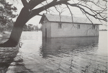
Photograph - Lake Wendouree, Ballarat School of Mines Boathouse on Lake Wendouree, c1977
A weatherboards Boathouse on Lake Wendoureeballarat school of mines boat house, boat house, lake wendouree, library, reference librarian -
Glenelg Shire Council Cultural Collection
Photograph - Copy of Photograph - Annie Clarke's Girls School, 1859
Vern Mc Callum CollectionDigital copy of a monochrome photo. Taken in Portland in 1859. Annie Clarke's Girl School,staff and students standing on front verandah. Building is weatherboard, with shingle roof. -
 Eltham District Historical Society Inc
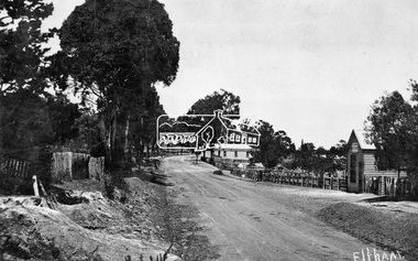
Negative - Photograph, Tom Prior, Main Road near Eltham Railway Station, c.1910
View looking south along Main Road, Eltham from near present day Luck Street. On the immediate right is a fence with the words “Hot Water” painted on it followed by William J Capewell’s butcher shop, then the slaughter yard and saleyards with the entrance access to the railway station. Contained within the saleyards facing the street, a small shelter with the name H.H. Clark upon it. Horace Harold Clark was the son of Eltham State School’s first Head Teacher, David George Clark. As well as being a farmer, he was an Estate Agent and conducted auction sales, presumably from this shelter. The large weatherboard building on the corner (opposite present-day Arthur Street) with signs for Summer Drinks and Hot Water painted on the side is Luther and Ada Haley’s General Store and Bakery, built 1902. This was the first building in what is now Eltham’s present shopping town centre. Haley previously ran the General Store and Bakery on the corner of Main Road and York Street until his lease expired and the premises were bought by Mrs Sarah Burgoyne in 1902. The store later was known as Staff's Store. In the distance approximately mid-way between the Butcher shop and the Bakery are the tops of what appears to be two cypress trees, which could well be the trees in front of the Shillinglaw Cottage facing Main Road. On the eastern (left) side of Main Street is Haley’s Paddock, which was used on occasions for community picnics. Capable of holding 10,000 people, with ample shade and hilly surroundings it was an ideal place for any community gathering such as the State Schools’ Picnic in 1904. Picture dated as c.1910 based on similar picture published in the Weekly Times, Feb. 1912. Kerb and channelling added 1923. Cross Ref: 610 (looking north), 611 (later stage), 613. Same as 705 (though in better condition)This photo forms part of a collection of photographs gathered by the Shire of Eltham for their centenary project book,"Pioneers and Painters: 100 years of the Shire of Eltham" by Alan Marshall (1971). The collection of over 500 images is held in partnership between Eltham District Historical Society and Yarra Plenty Regional Library (Eltham Library) and is now formally known as the 'The Shire of Eltham Pioneers Photograph Collection.' It is significant in being the first community sourced collection representing the places and people of the Shire's first one hundred years.Digital image 4 x 5 inch B&W Neg 120 format B&W negative (spare)shire of eltham pioneers photograph collection, eltham, main road, butcher, eltham railway station, railway station, w.j. capewell, baker, eltham town centre, general store, luther haley, reynolds prior collection, shops, haley's paddock, hot water, m.m. clark, sign, summer drinks, eltham sale yards, eltham slaughter yard, staffs general store -
 Federation University Historical Collection
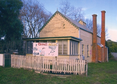
Photograph, Val D'Angri, Former Clunes School of Mines, c2000, c2000
On 29 February 1892 'The Argus' reported on the first Annual Meeting of the Clunes School of Mines. "The annual meeting of the council of the Clunes School of Mines was held last evening at the town-hall. In place of members of the council retiring by effluxion of time the following were elected: — Rev. Elder Gray, Messrs. John Beveridge, R. Nichol, J. Bryant, W. T. Pitcher, J. H. Daley, and T. Gilbert. The first annual report, showing remarkable progress, was received and adopted. The following officers were elected for the ensuing year: — Rev. E. Grey, president; Rev. Father John Barrett and Dr. Gordon, vice- presidents; Mr. Joseph Bryant, hon. director; Mr. W. Y. Witherden, hon. treasurer, Mr. H. E. Sando retained the office of secretary, and the officers for the time being were appointed trustees." Great satisfaction was expressed with the success of the school, and the progress and extent of the classes. It was referred to a sub committee to make arrangements for allowing the free inclusion, in certain classes, of a limited number of boys and girls of 14 and upward, who on examination qualified themselves for the privilege. An offer by an anonymous resident to pay the fees for four miners for admission to any class in the school was announced by the president, and received with thanks.Two photographs showing the exterior of a weatherboard building known as the former Ballarat School of Mines Clunes campus. The Timber hall was erected as a School of Mines and later used by the Australian Natives Association. The retort furnace (indicated by the large chimney) is still located in the rear rooms.ballarat school of mines, assaying, clunes school of mines, john beveridge, r. nichol, j. bryant, w. t. pitcher, j. h. daley, t. gilbert, e. grey, john barret, joseph bryant, w. y. witherden, h. e. sando, schools of mines -
 Federation University Historical Collection
Photograph - Photograph (black & White), Ballarat School of Mines from Albert Street, c1936
The Ballarat School of Mines was the first of its type in Australia. The Albert Street frontage was the 'working end' of the campus with the mining laboratory, gauge tower and caretakers cottage. All the structures in the foreground have been demolished to make way for the Flecknoe Building and the M.B. John Building. Harry Brew, the well known Ballarat School of Mines caretaker, lived in the small weatherboard building to the right of the photograph. He was appointed to the staff at the Ballarat School of Mines in 1936.Black and white photograph showing the Ballarat School of Mines from Albert Street. Henry Richards Caselli's Gauge Tower is in the foreground. To its left is the Mining Laboratory, and to it's right is the caretakers cottage.verso 'SMB. Albert St frontage, showing (Harry Brew's) edge of his cottage. harry was a likeable character in his day, he was an old sailor boy, served, on HMAS Physice, & was an expert in , bugs and such like, crawling beasties (signature undecipherable)ballarat school of mines mining laboratory, caretaker's cottage, harry brew, henry caselli, hr caselli henry richards caselli -
 Federation University Historical Collection
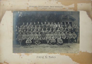
photograph - Black and White, Officers and Non-Commissioned Officers School, Field Artillery, February 1913, 02/1913
A mounted black and white photograph of uniformed men in front of a weatherboard building. They are officers and non commissioned officers of the Field Artillery School, February 1913, 6th and 7th batteries.To Staff Sgt Major Masters. army, field artillery, field artillery school, masters, staff sergeant major masters, volunteer regiment, major masters -
 Federation University Historical Collection
Booklet, Thomas Stephen Hart, The Highlands and Main Divide of Western Victoria, 1907, 12/12/1907
Thomas S. Hart was a teacher at the Ballarat School of Mines, and a member of the Ballarat Field Naturalists ClubArticle with illustrations published by the Royal Society of Victoria by Thomas S. Hart. The following plates are included: Fig 1. The Main Divide and some of the transverse ridges Fig 2. Hills on and near the Divide at the Ercildoun and Ascot Gaps Fig. 3. Profile of the Divide at Ascot Gap. Fig. 4. Sketch of the Hills west and north-west from Mt Buninyong - - The divide in Ascot Gap from Mt Blowhard (Serra Range, Mt William, Mt Ararat, Larne Gerin, Ben Major, Mt Cole, Mt Misery, Mt Bolton) Fig. 5. Diagram to illustrate the possible courses of the leads south of the present Divide - Burrumbeet Basin (Smythesdale, Ballarat, Lal Lal , Mt Doran, egerton, Parwan Creet, Rowsley Fault, Eastern Plateau) Fig. 6. Diagramatic cross section of the grampians, south of Hall's Gap. Profile of the Pyranees, from maiden Hill - Diagramatic Section of the Grampians south of Hall's Gap. (Mt Cole, Mt Mitchell, Ben Major, Ben More, Avoca Hill, Hall's Gap.) Fig. 7. Profile of the Pyrenees as seen from Maiden Hill near Waubra.thomas hart, thomas s. hart, ballarat school of mines, ballarat field naturalists club, royal society of victoria, western victoria, ballarat, great dividing range, mt william, volcano, volcanic plains, waterways, lal lal basin, yarrowee creek, ballarat common, lava flow, wendouree, warrenheip, ballarat plateau, mt elephant, grampians, t.s. hart, mt buangor, mt beckworth, mt misery, mt bolton, lal lal iron ored, mt ararat, mt wiliam, mt cole, burrumbeet, mt warrenheip, daylesford, waubra, ercildoun gap, smythesdale, lal lal falls, parwan valley, burrumbeet creek, staffordshire reef, pyranees, bacchus marsh, rowsley fault, ben nevis, avoca hill, landsborough hill, mt blowhard, weatherboard, mclean's hill, fyan's creek, thomas stephen hart, lal lal -
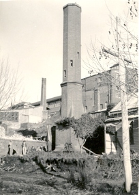
 Federation University Historical Collection
Photograph - black and white, Ballarat School of Mines Caretaker's Cottage, 1955, 03/1955
Black and white photograph of the small weatherboard building in the grounds of the Ballarat Junior Technical School's sport ground, known as the Battery Paddock. In the background is the south end of the Ballarat Junior Technical School building. ballarat school of mines caretaker, caretaker's cottage, ballarat junior technical school, battery paddock -
 Federation University Historical Collection
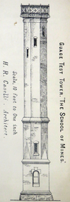
Architectural Plan, Ballarat School of Mines Gauge Tower Architectural Plan, c1883
The Ballarat School of Mines was the first of its type in Australia. The Albert Street frontage was the 'working end' of the campus with the mining laboratory, gauge tower and caretakers cottage. All the structures in the foreground have been demolished to make way for the Flecknoe Building and the M.B. John Building. Harry Brew, the well known Ballarat School of Mines caretaker, lived in the small weatherboard building to the right of the photograph. He was appointed to the staff at the Ballarat School of Mines in 1936.Printed copy of an architectural plan for the Ballarat School of Mines Gauge Tower as printed in the 1879 Ballarat School of Mines Annual Report.henry caselli, henry richards caselli, architectural plan, ballarat school of mines, gauge tower