Showing 123 items matching "wooragee"
-
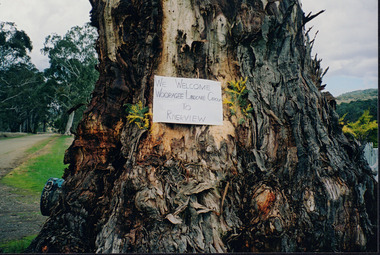
 Wooragee Landcare Group
Photograph, 27/2/2004
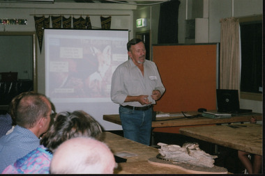
This photograph was taken at Wooragee Hall on the Friday 27th February, 2004 as part of an event called Foxy Night Out. This event was about sharing awareness about the impacts of foxes in rural areas and discussing methods to control their populations. There were two mains speakers at this event, the first; Camille Veselsky, a specialist in fox behaviour who worked for the Hume Rural lands Protection Board on pest animal control, and the second; Leanne Wheaton, a nature conservationist. Pictured in this photograph is Camille Veselsky giving his presentation. Regional areas like Wooragee are susceptible to fox attacks due to the availability of food such as rubbish, scraps, native wildlife and livestock. Foxes can have a huge impact on native wildlife and domestic life as they are known to chew through irrigation systems, dig-up and defecate in gardens, raid rubbish bins and harass other domestic animals.This photo is a record of the events that Wooragee Landcare organises in order to raise awareness and educate about environmental conservation issues in the area. It shows practical solutions that have been considered in fox controlLandscape coloured photograph printed on gloss paperReverse: WAN NA 0A2A0N0 NNN+ 1 6329 / [PRINTED] (No.6A) / 495 Camille Veselsky / Foxy Night out / 27/2/04foxy night out, wooragee hall, wooragee landcare group, wooragee landcare's collection, camille veselsky -
 Wooragee Landcare Group
Photograph, 3rd April 2004
This photograph depicts fox behaviour specialist Camille Veselsky demonstrating the use of a fox bait trap at an event conducted as part of an awareness campaign highlighting damage done to farm and domestic animals and native wildlife in April 2004. Camille Veselsky is a specialist in fox behaviour who worked for the Hume Rural lands Protection Board on pest animal control for 27 years. This date is suggested by the photograph's position in the 2004-2005 Wooragee Landcare Group Coordinator's Report folder. A note accompanying the item suggests an alternative date of 24th June 2004, however. This event raised awareness about the impacts of foxes in rural areas and provided practical training in techniques to control their populations. Flyers contained in the parent folder suggest that baiting may have been agreed as a method of fox control as the event depicted was followed by a two week baiting campaign a fortnight later. Pictured in this photograph, left to right: unknown, unknown, Quentin Mansfield, Graeme Missen, unknown, Helmut Wiemann, presenter Camille Veselsky, Ursula Wiemann, unknowns. A note accompanying the items suggests the photograph may have been taken by Karen Bowley or Maree Missen. In the folder, the photograph is accompanied by a printed label stating: 'Sensible precautions must be taken when handling FOXOFF.' Regional areas like Wooragee are susceptible to fox attacks due to the availability of food such as rubbish, scraps, native wildlife and livestock. Foxes can have a huge impact on native wildlife and domestic life as they are known to chew through irrigation systems, dig-up and defecate in gardens, raid rubbish bins and harass other domestic animals. Ground-dwelling native species are particularly susceptible to predation by foxes, which when combined with loss of habitat can endanger these species. Affected species include Speckled Warblers, Plovers, Diamond Firetails, Spotted Quail-Thrushes, Turquoise Parrots, Dunnarts, Bandicoots, Phascogales, skinks, geckos and legless lizards. This photograph is significant as an example of awareness raising and threat control programs undertaken by Wooragee Landcare Group in the 2000s in Indigo Shire. Landscape coloured photograph printed on gloss paper. Reverse: WAN NA 0ANA2N0 NNN+ 3 8743 / [PRINTED] 24 / [HANDWRITTEN] (No. 1 1) / 257 [PRINTED}wooragee landcare, wooragee, north-east victoria, indigo shire, landcare movement, 2004, fox control, pest control, native animal protection, farming, farm life, foxes, vermin, baiting, traps, speckled warbler, plovers, diamond firetails, spotted quail-thrush, turquoise parrot, dunnarts, bandicoots, phascogales, skinks, geckos, legless lizard, chickens, ducks, guinea-pigs, camille veselsky, quentin mansfield, graeme missen, helmut wiemann, ursula wiemann, karen bowley, maree missen -
 Wooragee Landcare Group
Photograph, 20th June 2004
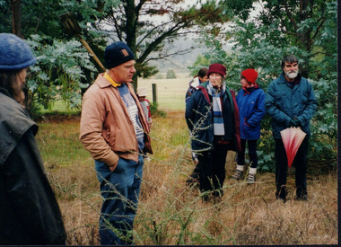
This photograph was taken on the 20th June 2004 as part of an event called "Successful Tree Planting!", organised by the Wooragee Landcare Group. It was addressed to all local residents and landholders in the area and involved practical demonstration of techniques suitable for successful planting of native trees and shrubs, as well as information about weed control. In the photograph are illustrated from left to right the following people: Chris Robinson; Tony Prowse; unknown child; Lesley Finedon; Ann Henderson, unknown. Revegetation can improve the condition of remnant vegetation in the area and provide habitat for local animals. Correct species selection, including all layers of vegetation, along with proper weather conditions and adequate site preparation, can maximise the successful outcome. Weed-free conditions and protection from rabbits and kangaroos are two more factors contributing to a quick plant growth. Wooragee Landcare, since its establishment in 1998, has organised a series of events and activities in order to promote weed and pest control, provide assistance and knowledge to landholders and ensure sustainability and protection of natural vegetation.The photograph is an example of the type of events and activities organised by Wooragee Landcare to educate and inform local residents and landholders on the most suitable techniques for successful planting of native trees and shrubs. Wooragee Landcare, abiding by its mission statement, promotes best land management strategies and ensures sustainability through collaboration with local community and council agencies.Landscape coloured photograph printed on gloss paper. Reverse: WAN NA 0ANA0N0 BN1+ 1 1636/ [PRINTED] (No.21)/935/successful tree planting, wooragee landcare group, 20th june 2004, successful planting, native trees and shrubs, weed control, revegetation, remnant vegetation, habitat, local animals, species selection, weather conditions, site preparation, weed-free, rabbits, kangaroos, plant growth, 1998, sustainability, natural vegetation -
 Wooragee Landcare Group
Photograph, 3rd April 2004
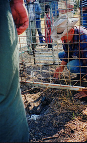
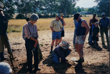
Wooragee Landcare, since its establishment in 1998, has organised a series of events and activities in order to promote weed and pest control, provide assistance and knowledge to landholders and ensure sustainability and protection of natural vegetation. This photograph was taken on the 3rd April 2004 as part of an event called "Spotlight on Fox", organised by the Wooragee Landcare Group. It was addressed to all landholders in the area and involved practical demonstration of techniques suitable for integrated fox control. Camille Velesky, who is illustrated in the photograph, was the presenter; he is a specialist in fox behaviour and has worked for 27 years on pest control. Under the Catchment and Land Protection Act 1994 (CaLP Act) foxes are declared as established pest animals and landowners have the responsibility to take reasonable steps to protect their land from established pest animals. The most commonly used management techniques are baiting, shooting, guard animals, fencing, trapping, canid pest ejectors, above-ground harbour removal, property hygiene and fumigation. Trapping, due to the significant suffering and distress that causes to foxes, has significant animal welfare implications and should be avoided if there is another suitable alternative. The photograph is an example of the type of events and activities organised by Wooragee Landcare to educate and inform local residents and landholders on the most suitable techniques for integrated fox control. Wooragee Landcare, abiding by its mission statement, promotes best land management strategies and ensures sustainability through collaboration with local community and council agencies.Portrait coloured photograph printed on gloss paper. Reverse: WAN NA 0ANA2N0 NNN+ 1 8743/ [PRINTED] (No.10)/256/spotlight on fox, wooragee landcare group, integrated fox control, camille velesky, fox behaviour, pest control, catchment and land protection act 1994, calp act, established pest animals, baiting, guard animals, fencing, trapping, trap setting demonstration, weed and pest control, sustainability, natural vegetation, fox dens, fumigation, animal welfare -
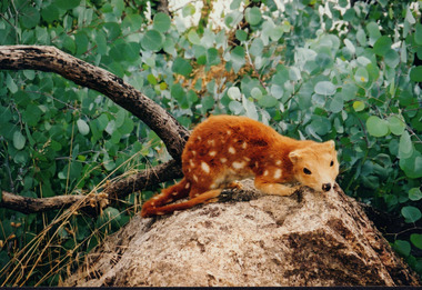 Wooragee Landcare Group
Photograph, 27th February 2004
Photograph of Quoll taxidermy, part of the Quoll presentation at the Wooragee Hall on Friday, 27th February, 2004 as part of an event called Foxy Night Out. Foxy Night Out is part of a land fox control project. This workshop is conducted to help private and public community members to understand foxes and effective fox control techniques, and its impact to agriculture and other animals. Quolls are carnivorous marsupials native to Australia and New Guinea. They grow up to 125cm and weighs up to 5kg. The spotted-tail Quoll is now the largest carnivore on the mainland. Quolls have black to fawn fur, white spots, long and thin tails. Quolls can attack livestock like chickens. They are known for sharp teeth that enables them to sustain a diet that involves poultry meat. They hunt for their families. Historically, Quolls are treated as pests and were trapped or poisoned by people who are protecting their chickens.This photograph contributes to the scientific and historical records on fox control in Victoria. It reflects the effects of foxes and quolls to livelihood, thus, creates a picture of Victorian agriculture, trade, and community activities. Coloured rectangular photograph printed on matte photographic paperReverse: WAN NA / 0ANA2N0 BN2+ 2 1636 / (No. 5) 919foxes, quoll, landcare workshop, taxidermy, ecosystem, fox control project, agriculture, fox, marsupials, carnivore, pests -
 Beechworth Honey Archive
Topographic Map, Beechworth, Australia
Map 1:50,000. Sheet 8225-111 Printed by Royal Australian Survey Corp, 1967. Map includes Beechworth, Everton, Muirmungee, Wooragee and Eldorado. -
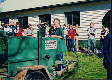 Wooragee Landcare Group
Photograph, August 27, 2004
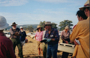
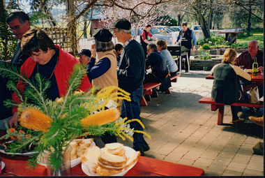
Taken on August 27, 2004, depicted are eighteen people who attended a Direct Seeding event held at Wooragee Hall in Wooragee, Victoria. The event was sponsored by Greening Australia, an independent environmental enterprise. The main speaker (pictured centre) is James Scholfield, a farmer from Hamilton Victoria demonstrating his 'Bandicoot Native Grass Harvester'. The photograph is an example of the type of event hosted by Wooragee Landcare and sponsored by Greening Australia to offer the public a science-led, collaborative approach to nature-based solutions addressing the twin crises of climate change and biodiversity loss.Colour rectangular photograph printed on matte photographic paper.wooragee, wooragee hall, wooragee landcare, wooragee landcare group, direct seeding, greening australia, wooragee landcare's collection -
 Wooragee Landcare Group
Photograph, 5 Sepember 2004
This photograph was taken at Riverview Farm, Victoria on Sunday the 5th of September as part of a day trip by the Wooragee Landcare Group. The event was about looking at land use on small farms and as a social get-together for the Group. Wooragee was also researching how small landholders could run some enterprises around the time of the trip. This photograph includes Julius Holt, Graeme Missen, Peter and Lesley Finedon, Sue Brunskill, Jacky Luisi, Bonnie Payne, Bob and Christine Stewart, Oliver Payne, and Gerri Boland. Wooragee Landcare Group was created in 1988. Its core mission is to work towards eradicating animals and pests from the land to protect the natural vegetation and promote revegetation projects.This photograph is a great example of the type of events that Wooragee Landcare Group has organized, while educating the public about the importance of land use management.Reverse: WAN NA E0NA2N2. NN1- 3 4556 / [PRINTED] (No. 9) / 188wooragee, wooragee landcare group, wooragee landcare's collection, land use, social, riverview farm, animals, pests -
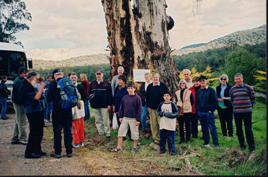
 Wooragee Landcare Group
Photograph, 5 September 2004
This photograph was taken at Tatong Tavern, Victoria on Sunday the 5th of September as part of a day trip by the Wooragee Landcare Group. The event was about looking at land use on small farms and as a social get-together for the Group. Wooragee was also researching how small landholders could run some enterprises around the time of the trip. This photograph includes Jo Luisi, Bob Bennet, Christine Stewart, and Julius Holt. Tatong Tavern was built in the 1880's as Tatong Hotel or 'Pub' hotel for Mr. William Worrall. The original hotel was destroyed in 1923 by a fire, but was rebuilt for Mr. M. C. Clarke. The building is a representation of the changing society, as it changes as its uses and visitors change. The photograph shows the beer garden, which has been added more recently. The Tavern has a bar, restaurant, and accommodation area. Wooragee Landcare Group was created in 1988. Its core mission is to work towards eradicating animals and pests from the land to protect the natural vegetation and promote revegetation projects.This photograph is a great example of the type of events that Wooragee Landcare Group has organized, while educating the public about the importance of land use management. It showcases the social aspect of the Group, as well as the historic Tatong Tavern. Landscape colored photograph printed on gloss paper. Reverse: WAN NA E0NA2N2. NNN+ 1 4240/ [PRINTED] (No. 22) / 375wooragee, wooragee landcare group, wooragee landcare's collection, land use, social, tatong tavern, tatong hotel, tatong pub -
 Wooragee Landcare Group
Photograph, 5 September 2004
This photograph was taken at Tatong Tavern, Victoria on Sunday the 5th of September as part of a day trip by the Wooragee Landcare Group. The event was about looking at land use on small farms and as a social get-together for the Group. Wooragee was also researching how small landholders could run some enterprises around the time of the trip. This photograph includes Christine Stewart, Julius Holt, Graeme Missen, Peter Finedon, and Sue Brunskill. Tatong Tavern was built in the 1880's as Tatong Hotel or 'Pub' hotel for Mr. William Worrall. The original hotel was destroyed in 1923 by a fire, but was rebuilt for Mr. M. C. Clarke. The building is a representation of the changing society, as it changes as its uses and visitors change. The photograph shows the beer garden, which has been added more recently. The Tavern has a bar, restaurant, and accommodation area. Wooragee Landcare Group was created in 1988. Its core mission is to work towards eradicating animals and pests from the land to protect the natural vegetation and promote revegetation projects.This photograph is a great example of the type of events that Wooragee Landcare Group has organized, while educating the public about the importance of land use management. It showcases the social aspect of the Group, as well as the historic Tatong Tavern.Landscape colored photograph printed on gloss paper. Reverse: WAN NA E0NA2N2. NNN+ 2 4240 / [PRINTED] (No. 23) / 376wooragee, wooragee landcare group, wooragee landcare's collection, land use, social, tatong tavern, tatong hotel, tatong pub -
 Wooragee Landcare Group
Photograph, 5 September 2004
Wooragee Landcare was formed in 1989 to promote sustainable conservation and land-use practices in the North-East region of Victoria. The organisation's work has included public awareness and education campaigns to control invasive, introduced species and protect native wildlife, such as campaigns to replant native plant species to improve soil integrity and restore habitat for flora and fauna. The organisation has drawn on the work of a variety of Government and academic experts to ensure best practice approaches are utilised. This photograph was taken at Riverview Farm, Victoria on Sunday the 5th of September as part of a day trip by the Wooragee Landcare Group. The event was about looking at land use on small farms and as a social get-together for the Group. Wooragee was also researching how small landholders could run some enterprises around the time of the trip. This photograph is a great example of the type of events that Wooragee Landcare Group has organized, while educating the public about the importance of land use management.Landscape colour photograph printed on gloss paper. Reverse: WAN NA E0NA2N2. NNN+ 4 4240/ [PRINTED] (No. 24) / 377wooragee, wooragee landcare group, wooragee landcare's collection, land use, social, riverview farm, animals, pests, indigo shire, tatong, samaria, north-east victoria -
 The Beechworth Burke Museum
Photograph, c1900
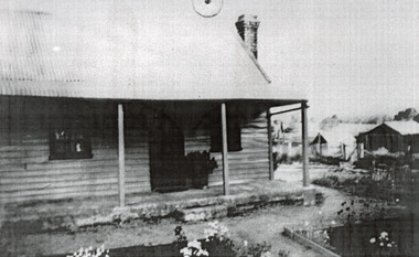
This photograph shows a small timber house in Wooragee. In 1855, the Ovens district made a shift towards farming development that included the sales of land in the Wooragee Valley. This shift came because of miner's demands and concern about stabilising the area around the goldfield. Continual migration needed to be supported, unlucky diggers needed alternative employment, and there was a lack of affordable fresh produce available on the goldfields. Initially, the cost of land in areas like Wooragee was prohibitive, and miners chose to squat rather than overpay for poor land. Throughout the 1850s and 1860s, land reform was a key topic for miners and politicians, as they attempted to improve land access and protect financial interests. This photograph is an example of rural development in the Wooragee area, showing the cottage, tents, and garden beds. While the date is unknown, the image nevertheless links us to the 1850s-1860s story of rural development in Indigo Shire. Black and white rectangular photo, copy of original, printed on paper. wooragee, timber, timber cottage, corrugated iron, cottage, housing, tents, gardening, farming, farming and agriculture, construction, garden bed, flowers, verandah, squatting, tent, field -
 Wooragee Landcare Group
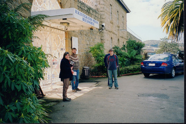
Photograph, 2004
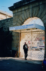
This photo was taken in 2004 and pictures Luke Bailey and Glen Scholfield, the Wooragee Landcare Group coordinator, outside Beechworth Prison. This was the last year Wooragee Landcare Group met with Beechworth Prison Farm and Industry Managers at the prison itself, where they discussed weed and rabbit control on the prison's 'Rockery' block. The weed and rabbit controls that were explored in this event aimed to educate people on how to manage common pests in the Wooragee landscape and improve the appearance of the Beechworth Prison. The Beechworth prison itself is significant as it was built between 1859 and 1864 and is designed using a radiating 'panopticon' method which had proved an efficient, cost-effective design for easy surveillance of prisoners by allowing guards to watch over a large area from a central observation point. The prison is historically significant for its association with the early development of Beechworth as the government administrative centre of north-eastern Victoria. It is part of a major precinct of public buildings and has links to numerous other places in Beechworth which used granite quarried and broken at the prison by male inmates. It is also significant for its associations with the bushranger Ned Kelly and the Kelly storyThe photo holds significance due to the social and educational context the image holds in representing the events Wooragee Landcare Group held in order to educate the public. The photograph also exemplifies the historic significance of the area due to the Beechworth Prison's relation to important historical eras and events.Landscape coloured photograph printed on gloss paperReverse: WAN NA E0NA0N2. NN1- 1 2906 / [PRINTED] (No.15) / 870wooragee, wooragee landcare, wooragee landcare group, beechworth prison, h.m beechworth prison, beechwoth gaol, ned kelly, greg johnson, agriculture victoria, department of primary industries, dpi -
 Wooragee Landcare Group
Photograph, April 3, 2004
This photograph was taken at an event called Spotlight on Fox on 3rd April 2004. This event was a practical demonstration of methods landowners could use to help control the fox population. Camille Veselsky, a specialist in fox behaviour who worked for the Hume Rural lands Protection Board on pest animal control, was the presenter and demonstrator. He is pictured here kneeling Regional areas like Wooragee are susceptible to fox attacks due to the availability of food such as rubbish, scraps, native wildlife and livestock. Foxes can have a huge impact on native wildlife and domestic life as they are known to chew through irrigation systems, dig-up and defecate in gardens, raid rubbish bins and harass other domestic animals.This photo is a record of the events that Wooragee Landcare organises in order to educate and provide practical demonstrations to mitigate environmental conservation issues in the area. It shows practical solutions that have been considered in fox controlLandscape coloured photograph printed on gloss paperReverse: WAN NA 0A2A0N0 NNN+ 1 8743 / [PRINTED] (No.7) / 253spotlight on fox, camille veselsky, wooragee, wooragee landcare, wooragee landcare group, fox -
 Wooragee Landcare Group
Photograph, 5 September 2004
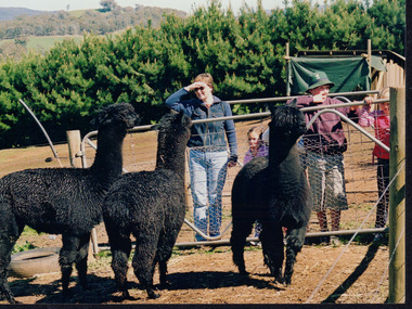
This photograph was taken at Samaria Farm on Sunday the 5th of September as part of a day trip by the Wooragee Landcare Group. The event was about looking at land use on small farms and as a social get-together for the Group. Wooragee Landcare was also researching how small landholders could run some enterprises around the time of this trip. Samaria Farm is located in northeast Victoria, near Mount Samaria, which is located 130 km northeast of Melbourne. Samaria Farm was owned by Sue and Due Matheson at the time of the trip and had a renowned rose garden, pigs, poultry, alpacas, and goats on their nine-hectare farm. The rose garden consists of 3000 damask roses. Samaria Farm distils the oil from these roses and is the only farm in Australia to do this. Rose oil has historically been used for religious and medical use. 20 kg of rose buds are picked by hand every day, which is then distilled and produced 5 to 8 ml of oil. The entire four-week season produces 80 to 100 ml of oil. Rose water is also created during this process and produces about 300 litres per season. Along with the oil, the Farm also harvests lemons, lime, olives, and oranges. The Farm is currently owned by Utako and Anthony since 2022, with Vicki and Allan Wight being the previous owners. Wooragee Landcare Group was created in 1988. Its core mission is to work towards eradicating animals and pests from the land to protect the natural vegetation and promote revegetation projects. This photograph is a great example of the type of events that Wooragee Landcare Group has organized, while educating the public about the importance of land use management. The group is important to the community and for the environment.Landscape coloured photograph printed on gloss paperReverse: WAN NA E0NA2N2. NNN+ 2 4240/ [PRINTED] (No. 18) / 371samaria farm, wooragee, wooragee landcare group, wooragee landcare's collection, samaria, small farm, land use, social, rose oil, damask roses, pests -
 Wooragee Landcare Group
Photograph, 5 September 2004
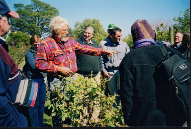
This photograph was taken during a bus excursion to Tatong in North East Victoria, held by the Wooragee Landcare Group in September 2004. The purpose of the excursion was to look at land use on small farms. As part of this, the excursion included a visit to Samaria Farm, run by Sue and Don Matheson. In this photo, taken at Samaria Farm, Don Matheson is discussing the management of his commercial rose garden. Events like this meet Wooragee Landcare's organisational goals of promoting best land management practices, cooperating and engaging with landowners, and providing information on plant management and care. This object is significant as a record of Wooragee Landcare's activities and community involvement. Landscape colour photograph printed on gloss photographic material. Reverse: "WAN NA E0NA2N2 NNN+ 1 4240/ don matheson, sue matheson, matheson, tatong, excursion, bus trip, wooragee landcare, wooragee, landcare, wooragee landcare group, samaria farm, roses, commercial rose garden, rose growing, education, activity, 2004, rose, farm, small farms, land use -
 Wooragee Landcare Group
Photograph, 5 September 2004
This photograph was taken at Samaria Farm on Sunday the 5th of September as part of a day trip by the Wooragee Landcare Group. The event was about looking at land use on small farms and as a social get-together for the Group. Wooragee Landcare was also researching how small landholders could run some enterprises around the time of this trip. Samaria Farm is located in northeast Victoria, near Mount Samaria, which is located 130 km northeast of Melbourne. Samaria Farm was owned by Sue and Due Matheson at the time of the trip and had a renowned rose garden, pigs, poultry, alpacas, and goats on their nine-hectare farm. The rose garden consists of 3000 damask roses. Samaria Farm distils the oil from these roses and is the only farm in Australia to do this. Rose oil has historically been used for religious and medical use. 20 kg of rose buds are picked by hand every day, which is then distilled and produced 5 to 8 ml of oil. The entire four-week season produces 80 to 100 ml of oil. Rose water is also created during this process and produces about 300 litres per season. Along with the oil, the Farm also harvests lemons, lime, olives, and oranges. The Farm is currently owned by Utako and Anthony since 2022, with Vicki and Allan Wight being the previous owners. Wooragee Landcare Group was created in 1988. Its core mission is to work towards eradicating animals and pests from the land to protect the natural vegetation and promote revegetation projects. This photograph is a great example of the type of events that Wooragee Landcare Group has organized, while educating the public about the importance of land use management. The group is important to the community and for the environment. Landscape colored photograph printed on gloss paperReverse: WAN NA E0NA2N2. ANN+ 1 4240/ [PRINTED] (No. 19) / 372samaria farm, wooragee landcare group, wooragee, victoria, mount samaria, farming, roses, rose oil, damask roses, agriculture, pests, vegetation -
 Wooragee Landcare Group
Photograph, 2004
This photo was taken in 2004 and pictures Greg Johnson, who worked at Agriculture Victoria (formerly known as the Department of Primary Industries, DPI), outside Beechworth Prison. This was the last year Wooragee Landcare Group met with Beechworth Prison Farm and Industry Managers at the prison itself, where they discussed weed and rabbit control on the prison's 'Rockery' block. The weed and rabbit controls that were explored in this event aimed to educate people on how to manage common pests in the Wooragee landscape and improve the appearance of the Beechworth Prison. The Beechworth prison itself is significant as it was built between 1859 and 1864 and is designed using a radiating 'panopticon' method which had proved an efficient, cost-effective design for easy surveillance of prisoners by allowing guards to watch over a large area from a central observation point. The prison is historically significant for its association with the early development of Beechworth as the government administrative centre of north-eastern Victoria. It is part of a major precinct of public buildings and has links to numerous other places in Beechworth which used granite quarried and broken at the prison by male inmates. It is also significant for its associations with the bushranger Ned Kelly and the Kelly storyThe photo holds significance due to the social and educational context the image holds in representing the events Wooragee Landcare Group held in order to educate the public. The photograph also exemplifies the historic significance of the area due to the Beechworth Prison's relation to important historical eras and events.Portrait coloured photograph printed on gloss paperReverse: WAN NA E0NA0N2. NNN- 3 2906 / [PRINTED] (No.13) / 868wooragee, wooragee landcare, wooragee landcare group, beechworth prison, h.m beechworth prison, beechwoth gaol, ned kelly, greg johnson, agriculture victoria, department of primary industries, dpi -
 Wooragee Landcare Group
Photograph, 27 August 2004
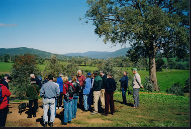
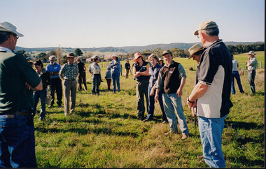
This photograph was taken on Friday the 27th of August 2004 as part of an event called 'Direct Seeding Expo'. This event was one of many held by the Wooragee Landcare Group in the early 2000s which aimed to educate the local community on certain agricultural and biodiversity conservative techniques. This particular photograph shows attendees at the property of Neil and Anne Nankervis, inspecting sites where direct seeding had been used ten months earlier. Three different direct seeding techniques were demonstrated during the day by several experts in the field. Direct seeding involves the sowing of seeds directly into the soil to achieve germination and establishment. It is an alternative to planting seedlings in a contained nursery plot. This direct method is intended to mimic a more natural process of growth, revegetating larger areas in a more efficient manner.This photograph is significant as it provides evidence of a project undertaken by the Wooragee Landcare Group in the early 2000s to educate members of the public on alternative and potentially more efficient methods of planting seedlings. The Wooragee Landcare Group has been instrumental in the co-ordination of programs relating to biodiversity protection in the local area, providing great assistance to landholders.Landscape coloured photograph printed on gloss paperReverse: WAN NA EONA2N2. ANN+ 1 4240 / neil and anne nankervis, wooragee, wooragee landcare group, wooragee landcare, direct seeding expo, direct seeding, seeding, seedlings, direct seeding sites, alternative seeding, alternative seeding method -
 Wooragee Landcare Group
Newsletter - Wooragee Landcare Group Bound newsletters Volume 2, pages 9 & 10
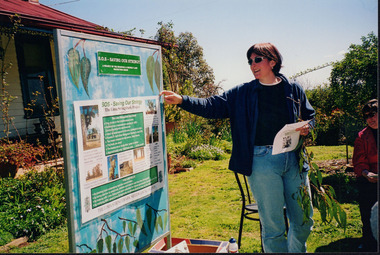
Topics in March 2000 newsletter include: International Landcare Conference 2000 summary Treasurers report Wooragee Community newsThis is an important item for the WLG being one of two bound series of newsletters prepared for the group by Owen Gemmillwooragee landcare group, landcare conference -
 Wooragee Landcare Group
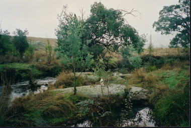
Photograph, circa April 2003
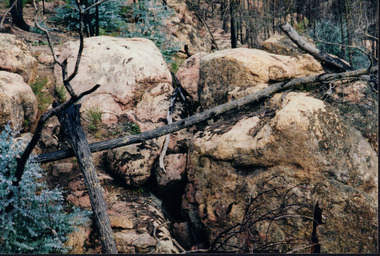
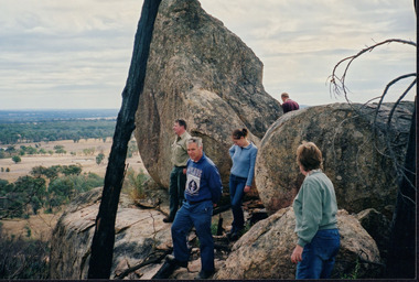
This is a photograph taken in the Chiltern - Mount Pilot National Park near Chiltern in Victoria. On this day, the Wooragee Landcare Group was in the national park looking for signs of the tiger quoll. Tiger quolls can be found in few places with the Chiltern - Mount Pilot National Park being one of them. This photograph is of a tiger quoll nesting site as tiger quolls often nest between large rocks. This image also shows the damage caused by the 2003 bushfires. These bushfires happened at the same time as the 2003 Alpine bushfires. This bushfire started by lightning and quickly became the largest fire in Victoria since the 1939 Black Friday bushfires. The Alpine bushfires destroyed 1.3 million hectares and burnt for 59 days before it could be controlled. The 2003 bushfires severely damaged the environment and concern was raised about the safety of tiger quoll. This photograph displays how the nesting site was damaged by the fire. This meant that the quoll itself could have also been impacted by the fire. Hence why the Wooragee Landcare group went for a search for signs of the quoll.This photograph is significant because it shows a tiger quoll nesting site. Tiger quolls are a highly valuable species because they live in very few places. This, in turn, makes their nesting site valuable. This photograph also signifies the impact of the 2003 bushfires on the Chiltern - Mount Pilot National Park. The image displays burnt trees which makes it clear that the fire was deeply damaging. The fallen log over the nesting site demonstrates how the bushfire must of put the tiger quolls at risk because of how the fire damaged their nesting site. Landscape coloured photograph printed on gloss paperReverse: WAN NA 0ANA0N0 NNN+ 1 1636 / [PRINTED] (No.9) / 923bushfires, mount pilot chiltern national park, mount pilot, chiltern, victoria, wooragee landcare group, wooragee landcare, wooragee, national park, tiger quoll, 2003 bushfires, beechworth, rocks, nesting site, photograph, 2003 alpine bushfires, 1939 black friday, 2003, hectares, fire, damage, burnt, burn -
 Wooragee Landcare Group
Photograph, 20th June 2004
Photo of streamside planting and rehabilitation at Bev DeJong and Bob Dunnett's place during a paddock demonstration and tree planting field day, called 'Really Successful Tree Planting!' run by Wooragee Landcare on Sunday 20th June 2004. Maintaining and reforesting native trees, shrubs and grasses are really important for a variety of reasons, including creating native habitat and food for birds and other animals, shade, biodiversity, visual appeal, cooling, shade for urban areas, sequestering carbon and conservation among other considerations. The planting must be consistent with the particular needs of the environment, such as trees or shrubs which would naturally occur and are native to the area. Tree planting demonstrations such as this one run by the Landcare Group ensures that the projects are being managed consistently with an overarching commitment to land protection and management and the best methods for best outcomes are employed.This photograph is significant as it provides evidence of a project undertaken by the Wooragee Landcare Group to educate themselves and members of the public on successful techniques needed to plant and maintain trees for replanting in the Wooragee area. The Wooragee Landcare Group has been instrumental in the co-ordination of programs relating to biodiversity protection in the local area, providing great assistance to landholders.Landscape coloured photograph printed on gloss paperReverse: WAN NA 0ANA2N0 AN1 0 1636 / [PRINTED] (No.25) / 938wooragee landcare, wooragee landcare group, beechworth, landcare group, wooragee, tree planting, successful tree planting, demonstration, paddock demonstration, tree planting field day, really successful tree planting, land protection and management, land management, native trees, conservation, streamside, streamside planting -
Federation University Historical Collection
Letter, Letter to School of Mines Ballarat from Geo Pardon
Ballarat School of Mines is a predecessor of Federation UniversityHandwritten lwetter on lined paperballarat school of mines, geo pardon, stone, assaying, wooragee -
 Wooragee Landcare Group
Photograph, 5 September 2004
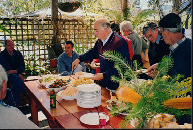
Wooragee Landcare Group took a bus trip Sunday 5th September to Samaria, Tatong area (near Benalla) to look at land use on small farms. Around this time, Wooragee Landcare were looking into how small land holders could run some enterprises. This photo was taken at Tatong Tavern where the group had lunch. The Tatong Tavern is an old English style pub situated in the foothills of the Great Dividing Range the small community of Tatong 23km south-east of Benalla. The original weatherboard hotel was originally built in the 1880s by William Worrall who was listed as Hotel Keeper from 1886 to 1910. It was destroyed by fire in 1923 and replaced by the current building, which has undergone many changes over the past 100 years. The name has also changed from the Tatong Hotel or ‘Pub’ to the current name of Tatong Tavern.Tatong is a rural village in north-east Victoria, set in undulating country that rises southwards to the Tolmie ranges. The name is thought to derive from an Aboriginal expression, possibly referring to something unseen. The Tatong pastoral run was taken up in 1847 and farm selections began in the 1870s. A school opened in 1890 (closed in 2006). Dairy herds were grazed on the Tatong flats and a cooperative creamery operated from 1892 until 1918. In 1914 a branch railway line was opened from Benalla to Tatong that carried farm produce and timber to Tatong, which had two sawmills in the 1920s. There was also a general store, a police station, and a livestock trucking yard. St Albans Church of England was built in 1921. Most of those buildings have now disappeared. The Tatong Tavern along with the Hall built in 1904 are the only remaining buildings. The Tatong Tavern is a significant tangible and visual representation of the area’s cultural and social history over the past 100 years. Coloured rectangular photograph printed on paperReverse: WAN NA E0NA2N2. NNN- 14240/ (No. 20) 373/ tatong, tatong pub, tatong tavern, tolmie ranges, tatong flats, benalla, wooragee landcare, wooragee landcare group, bus trip, samaria, land use, william worrall, 1800s, 2004, mount samaria -
The Beechworth Burke Museum
Audio - Oral History, Jennifer Williams, Desmond McIntosh, 27 July 2000
Desmond (Des) McIntosh was born in Beechworth in the old goldfield’s hospital in 1940. He was the third child born in a family of five children. His great-grandparents moved from Scotland to Yackandandah in the 1930s to pursue wealth in the gold boom, but only just made a living out of it. His grandfather eventually moved and lived in the Woolshed Valley, where Desmond’s parents came from. His family continued to live in the Woolshed Valley as dairy farmers until the 1950s and then moved to Beechworth. Desmond went to school in Wooragee but left when he was 15 to work as a salesman at Freeman’s Store in Beechworth. He worked there for nine years, and then started working in the prison service in Beechworth at what is now known as the Old Beechworth Gaol, or HM Prison Beechworth, where he worked for 27 years. Desmond was an active member of the Beechworth community outside of the Prison in the church and an APEX member (which is a social justice program run across Australia). In prison, he led work programs for the prisoners such as a gardening program where they grew the fresh vegetables and fruit that they would eat. This oral history recording was part of a project conducted by Jennifer Williams in the year 2000 to capture the everyday life and struggles in Beechworth during the twentieth century. This project involved recording seventy oral histories on cassette tapes of local Beechworth residents which were then published in a book titled: Listen to what they say: voices of twentieth century Beechworth. These cassette tapes were digitised in July 2021 with funds made available by the Friends of the Burke.Mr. Desmond McIntosh’s account of his life in Beechworth and the local area during the 20th century is historically and socially significant to the cultural heritage of the region. He details some of the change that occurred across Beechworth over time, as well as details about the management of the Old Goal Beechworth. His account is important to the region's history in terms of social issues and the effect WWII has on Beechworth. This oral history account is socially and historically significant as it is a part of a broader collection of interviews conducted by Jennifer Williams which were published in the book 'Listen to what they say: voices of twentieth-century Beechworth.' While the township of Beechworth is known for its history as a gold rush town, these accounts provide a unique insight into the day-to-day life of the town's residents during the 20th century, many of which will have now been lost if they had not been preserved.This is a digital copy of a recording that was originally recorded on a cassette tape. The cassette tape is black with a horizontal white strip and is currently stored in a clear flat plastic rectangular container. It holds up to 40 minutes of recordings on each side. Mr. Desmond McIntoshlisten to what they say: voices of twentieth century beechworth, beechworth, oral history, burke museum, desmond mcintosh, old goal beechworth, apex, wooragee, hm prison beechworth, woolshed valley, scotland, dairy farmer, freeman's store, gardening, garden, social justive -
 The Beechworth Burke Museum
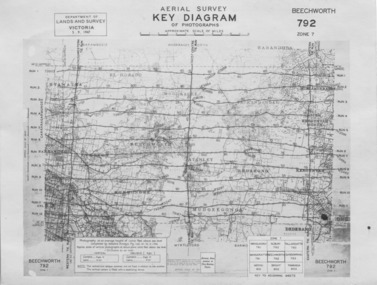
Photograph - Aerial Survey, 5/9/1947
This image is an Aerial Survey, Key Diagram of Beechworth and surrounding area. Issued by Department of Lands and Survey, Victoria in 1947. Photographed at an average height of 12300 feet above sea level, areas depicted are; Beechworth, Stanley, Bruarong, Baranduda, Muagegonga, Myrtleford, Everton, Wooragee North Tarrawinge, Dederang, Kergunyah North, Kergunyah, Yackandandah, El-Dorado, Barambogie, Murmungee, Barwidgee, Oxley, CarraragarmungeeBlack and white rectangular photograph. Image is printed on matt photographic paper and has a white un-printed border. Obverse: AERIAL SURVEY, KEY DIAGRAM OF PHOTOGRAPHS, APPROXIMATE SCALE OF MILES / DEPARTMENT OF LANDS AND SURVEY VICTORIA 5.9.1947. BEECHWORTH 792 ZONE 7. Reverse: BMM7010.1 (written in pencil) aerial survey, beechworth, burke museum, department of lands and survey, victoria, 1947 -
The Beechworth Burke Museum
Audio - Oral History, Jennifer Williams, Alan French, 1st June 2000
Alan French was born in Beechworth in 1918 on Christmas Day, an only child descendent from French, Irish and Scottish family who had moved to and stayed in the area years before, both of his parents were born in Beechworth and were fourth generation Indigo Shire locals. Alan grew up in the depression era working the land with his dad when they could, cutting wood or helping on the local farms in and around Wooragee. Everyone able in those days bartered for goods, little coin and vegetables if there was spare to go around with labour or what little they produced from their efforts. In this interview, Alan discusses how his great grandparents Francois (French) and Catherine (Irish) Bertrand were the first vignerons in Beechworth, even mentioned in Beechworth, a Titans Field; 'Vines were draped across 156 acres of Beechworth shire in 1880, and notable vignerons included Francois Bertrand [...]' (Woods: 162) according to Alan 'you can still see where the old vines used to be, Malakoff Rose Garden' but whether or not the wine they produced was any good for drinking is open to interpretation and lost to the history of Beechworth and those who tasted it. This oral history recording was part of a project conducted by Jennifer Williams in the year 2000 to capture the everyday life and struggles in Beechworth during the twentieth century. This project involved recording seventy oral histories on cassette tapes of local Beechworth residents which were then published in a book titled: Listen to what they say: voices of twentieth century Beechworth. These cassette tapes were digitised in July 2021 with funds made available by the Friends of the Burke.This oral history account is socially and historically significant as it is a part of a broader collection of interviews conducted by Jennifer Williams which were published in the book 'Listen to what they say: voices of twentieth-century Beechworth.' While the township of Beechworth is known for its history as a gold rush town, these accounts provide a unique insight into the day-to-day life of the town's residents during the 20th century, many of which will have now been lost if they had not been preserved.This is a digital copy of a recording that was originally captured on a cassette tape. The cassette tape is black with a horizontal white strip and is currently stored in a clear flat plastic rectangular container. It holds up 40 minutes of recordings on each side.listen to what they say, beechworth, oral history, burke museum, vigneron, a titans field, beechworth a titans field, francois bertrand, wooragee, indigo shire, depression era, wood cutting, labour, farming, vines, history, malakoff rose garden -
 The Beechworth Burke Museum
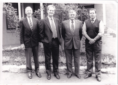
Photograph - Photograph - Reproduction, c1994
This photograph was taken in 1994 and depicts four Commissioners of the newly formed Shire of Indigo. The Commissioners were appointed on 18 November 1994 and served until the the election of Indigo Shire Councillor's on 15 March, 1997. The United Shire of Beechworth was established in 1871 following the merger of two entities: the Borough of Beechworth, established in 1856, and the Shire of Beechworth, which was created as the union of the Stanley and Wooragee Road Districts in 1865. This photograph is historically significant for its depiction of newly elected Indigo Shire Commissioners, who replaced the former United of Beechworth Shire Council. The only local government entity remaining in Victoria styled as a 'United Shire' at its dissolution in November 1994, the amalgamation of the United Shire of Beechworth, along with parts of the Shires of Chiltern, Rutherglen and Yackandandah into the Shire of Indigo, was part of an extensive restructuring of Victoria's Local Government Areas in the 1990s. The Victorian Governments restructuring of LGA's in the 1990s constituted a major transition in Victoria's systems of local governance. The reforms dissolved over two hundred councils and sacked sixteen hundred elected councillors. The Shire of Indigo was one of seventy-eight new councils that were subsequently created through amalgamations.Black and white rectangular photograph printed on photographic paper mounted on board.Reverse (original): Transcribed to DB / From left to right: Commissioner Kevin Gleeson ~ / Chairman of Commissioners, Mr Frank Burfitt ~ / Chief Executive Officer, Commissioner Kevin Crow, ~ / Commissioner Henry Brewer. / Commissioners were appointed to the Indigo Shire / on 18th November, 1994 and served until the / election of councillors on 15th March, 1997. / indigo shire council, shire councillors, indigo shire commissioners, governance, local government, beechworth, local representatives 1994-1997, lga restructuring, indigo shire amalgamation, victorian government, regional and rural governance, beechworth shire, yackandandah shire, chiltern shire, rutherglen shire -
 Wooragee Landcare Group
Photograph, 12th September 2004 or 15rh September 2004
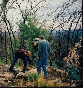
This photograph was taken at Wooragee Landcare workshop (Quoll), field day in Mt Pilot park on Bush Recovery: After the Fires. This is part of the Biodiversity Month on September 2004. The Bush Recovery workshop was held on Sunday 12th September 2-4pm with Christine Watson, Sue Berwick and Natasha Schedvin, and another workshop on Wednesday, 15th September, 9am to 12 noon with local biologist Glen Johnson and botanists Gill Earl and Christine Watson. The topics involved in the training involved what species have returned, what species haven't, what recovery studies are being carried out, how are the barking owls and phascogales faring, and why is Mt Pilot important. The photograph shows L-R: Colin Payne; Jerry Alexander; Geoff Galbraith. Bush fires are common in Australia due to several reasons. One is due to the geographic spread of fire's seasons, secondly, the absence of El Nino conditions are also linked to fires. Climate change also affected Australia's hot and dry seasons. Australia's climate began warming since the 1970s. Human-induced fires also contributed to this increase in temperatures across the nation. Bush fires happened in Mt Pilot in 2003 but it has recovered well since. This makes Mt Pilot an important site to understand bushfire recovery. This photograph contributes to the scientific and historical records on bushfire recovery in Victoria. It creates a picture of Victorian community activities and efforts on biodiversity, climate change, and environmental care.Landscape coloured photograph printed on gloss paperReverse: WAN NA 0A2A0N0 NN2 0 163 / (No. 2)wooragee, wooragee landcare group, wooragee landcare, bush fires, bush recover, mt pilot, biodiversity month, botany, botanists, bush recovery, quoll, foxy, fox, forest, environment, climate change, bushfire recovery, bushfires, 2004 bushfire, field work, after the fires, fire, biodiversity -
 Wooragee Landcare Group
Photograph, circa April 2003
This photograph was taken in the Mount Pilot Chiltern National Park. It was taken during a search for the tiger quoll conducted by a team of volunteers from the Wooragee Landcare Group. The tiger quoll is also known as the spotted-tail quoll and is found in the national park. The 2003 bushfires caused worry for the safety of the tiger quoll, hence the need for a search for it. Mount Pilot Chiltern National Park is located near Chiltern in Victoria. It's most notable landmarks include Mt Pilot and Woolshed Falls. It also has many mines from the Gold Rush in the late 1800s. It is home to much flora and fauna, including the tiger quoll. The park is also home to the box-ironbark forest that once was present in most of north-eastern Victoria. The park is a large tourist destination as in there are many bushwalks and other attractions for visitors. In 2003, bushfires raged through Mount Pilot National Park and destroyed much of the environment. Some of this damage can be seen in the burnt trees in the picture. This photograph represents the work that goes into protecting a important species like the tiger quoll and there has been much work done to preserve it. This photograph was taken when the Wooragee Landcare group went to ensure the survival of this species, highlighting how the tiger quoll is being protected. This photograph also demonstrates the significance of Mount Pilot Chiltern National Park. The park has many special flora and fauna that can only be found in this area. For example, the box-ironbark forest and the tiger quoll. The forest used to stretch over much of north-eastern Victoria and is therefore reminiscent of what that area of Victoria was once like. This park is historical for this reason but it is also historical through it being once goldfields from the Gold Rush in the 1800s.Landscape coloured photograph printed on gloss paperReverse: WAN NA 0ANA2N0 NNN- 1 1636 / [PRINTED] (No.8) / 922mount pilot, mount pilot chiltern national park, chiltern, victoria, landmark, woolshed falls, gold rush, tiger quoll, flora, fauna, spotted tail quoll, marsupial, andy murray, andy murray quolls, carnivorous marsupial, forests, rainforests, coastal heathlands, woodlands, photograph, species, wooragee, wooragee landcare group, wooragee landcare, bushfires, identification, search, dna, droppings, box ironbark forest, ironbark, box iron bark